It’s been another busy year on the Victorian Forests and Bushfire Heritage Facebook page.
Once again, I have gathered up the main stories into a free eBook and published them in the national and state libraries so they don’t get lost in the Facebook soup.
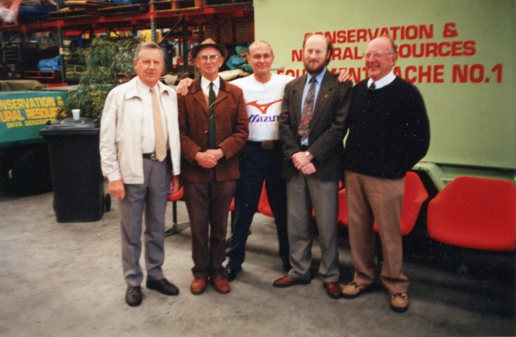
But the biggest achievement for 2024 has undoubtedly been photographing and cataloguing items in both the FCRPA Beechworth museum and the DEECA museum at Altona, and working to make them freely available online.
Two self-guided historical walks at Creswick have also been created – one around the VSF school grounds and another near the old sawpit gully nursery.
Please feel free to download and/or share the link to Series Five.
Finton George Gerraty was born on 23 September 1899 at Myrtleford. He entered the Victorian School of Forestry (VSF) at Creswick in 1915 and graduated two years later in 1917.
His postings with the Forests Commission Victoria included District Forester at Orbost in 1920, DFO Gellibrand in 1924 and then DFO Niagaroon (Taggerty District) in 1927.
Later in 1930, Finton was promoted as the Chief Forester at Powelltown, while only a short time later in 1935 he was elevated to the Inspector of Forests for the Central Division based at Healesville. He then moved to a similar role at Berwick in 1937.
Finton somehow found time to study towards a Diploma of Forestry (Victoria) and the topic of his thesis was “The regeneration, silvicultural development and utilisation of Eucalyptus obliqua – messmate stringybark”.
Never office bound, he is said to have personally measured a fallen mountain ash tree near Noojee after the 1939 bushfires at 338 feet and reported that “its top was tantalisingly broken off”.
Finton also took a strong interest in new technology such as the introduction of crawler tractors for logging at Marysville in the late 1930s, as well as the operation of Kurth Kiln at Gembrook to produce charcoal during the war years.
Finton Gerraty was considered by his peers as ambitious, keen, efficient and accurate. But he was sometimes described by his detractors as being a tough forester from the old hard school… whatever that means…
In March 1942, Finton joined the 12th Victorian Battalion of the Volunteer Defence Corps (VDC) with the rank of Captain. And during the latter part of the war, he was seconded to the Department of Army to examine and advise on the timber resources of the Northern Territory and then organise logging, transport and milling.
At the conclusion of the war in 1945, Finton assisted Associated Pulp and Paper Mills (APPM) in Tasmania to prepare a utilisation and roading plan for the company’s pulpwood procurement areas.
Within weeks of the end of the war, the Chairman of the Commission, A. V. Galbraith, outlined his vision for the future, or “Grand Design” as I prefer to call it. Then a quiet revolution began across Victoria’s forests and an epic story which took more than eighty years to unfold where several things were in play.
Undoubtedly, the main social and economic beneficiaries of Galbraith’s Grand Design were small rural settlements like Heyfield, Mansfield, Myrtleford, Bruthen, Orbost, Cann River, Colac, Alexandra and Swifts Creek which grew into thriving communities based upon the timber industry.
These communities became flourishing “Timber Towns” with jobs, decent housing, schools, shops, sporting clubs, public transport and health care. A more secure and safer place for families than the previous itinerant sawmills set deep in the bush, which was characteristic of the earlier period.
From May 1947, Finton was appointed as one of the three Forests Commissioners, and after the death of A V Galbraith in May 1949 he was elevated as Chairman. He then had the main task to implement the Grand Design that Galbraith had previously laid out.
In 1952, Finton travelled to England, Scotland, Norway, Sweden, Germany, Switzerland, Italy, Canada and USA investigating forestry practices and industries, particularly the economics of utilising lower grades of wood. And while he was away, he represented Victoria at the 6th Empire Forestry Conference at Quebec in Canada.
In 1956, the Commission’s Newport seasoning works closed under a controversial financial cloud. A situation made worse because Newport had barely ever been profitable. Newspapers accused the Forests Commission of “juggling the books” to turn a loss into a profit. There were also allegations of unexplained “leakage” of large quantities of valuable timber stocks.
Finton George Gerraty died suddenly of a heart attack at his home on 25 June 1956, right in the middle of the Newport crisis. The State Government was furious about the whole financial fiasco and there were calls for an independent inquiry and appointing an outsider to run the Forests Commission.
It took more than six months for the political and media dust to settle before Alf Lawrence was finally appointed as the replacement Chairman of the Forest Commission in December 1956. A role he occupied until his retirement in July 1969.
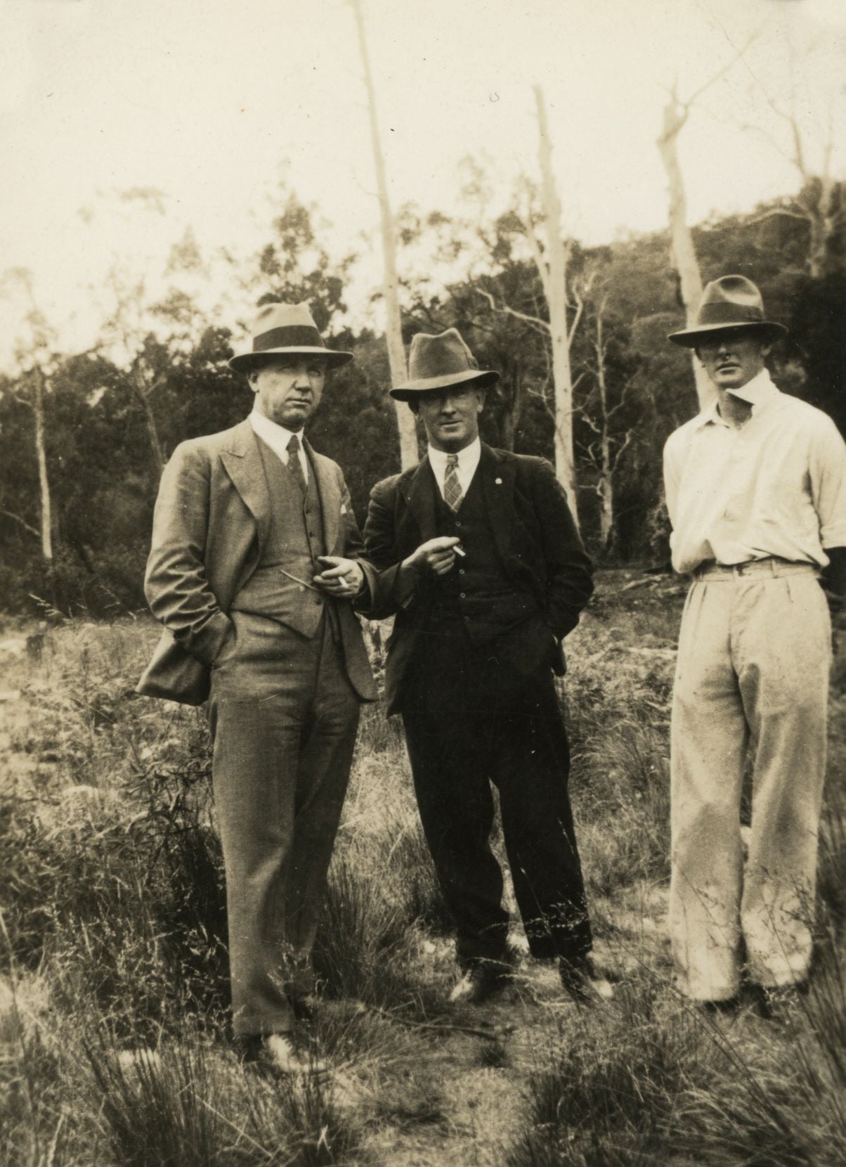
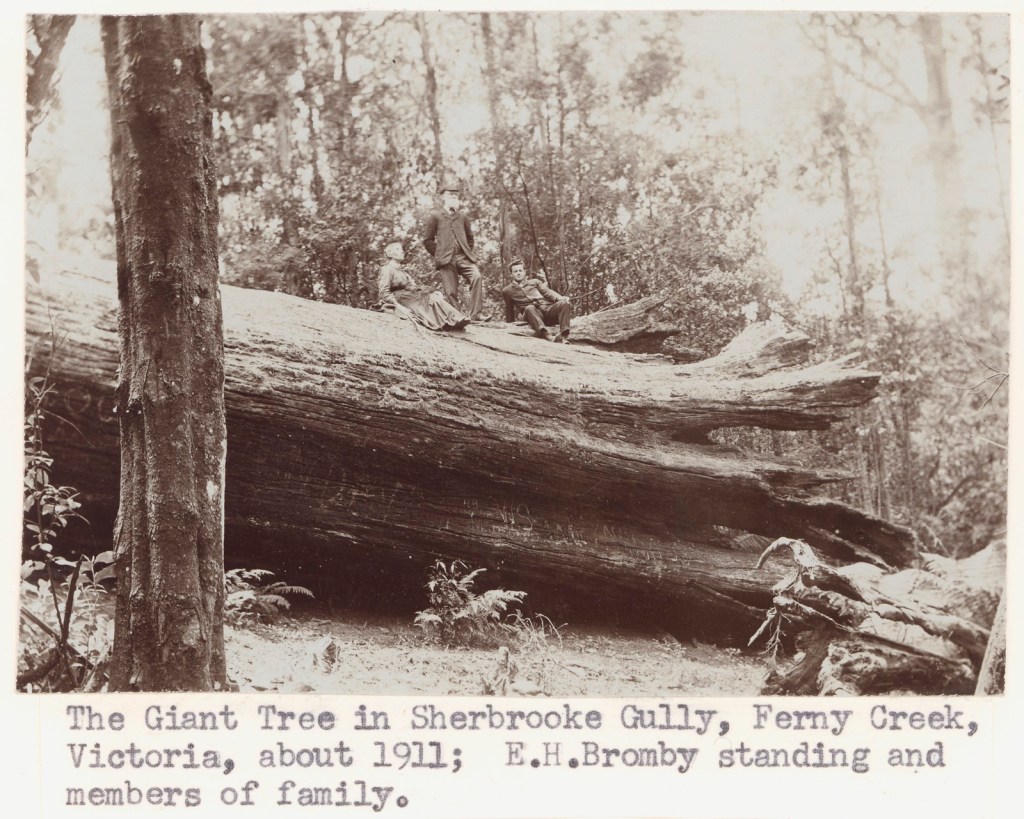
Photo: Looking more like mobsters than foresters. A.V .Galbraith, FCV Chairman, Finton George Gerraty, then Inspector of Forests and Herbert FitzRoy OIC Boys Camp at Rubicon. Photo: Allan Layton
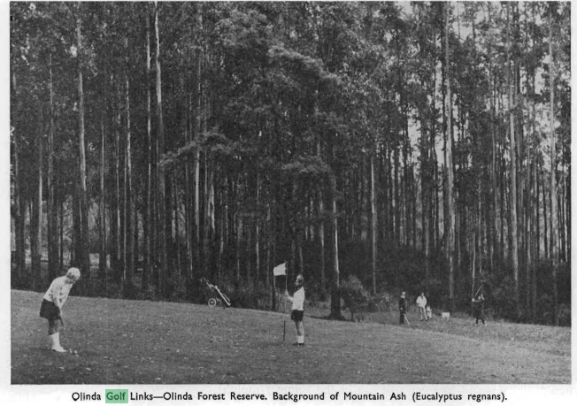
The suggestion of a golf club at Olinda in the Dandenong Ranges began circulating in 1905 and was revived again in 1931 as an idea to celebrate Victoria’s centenary.
The land was identified by the local community as a bushfire menace after the 1926 fires and many claimed that a well-maintained golf course would reduce the threat.
During the subsequent years several unsuccessful attempts were made to establish a golf course despite the amounts of monies raised. The Nicholas family of Burnham Beeches, Sir George Knox and Messrs Eric Leone, E J Gillies, W Brann and A P Dodd were active in public meetings and discussions with the Forests Commission. The Hon Gilbert Chandler also supported the project.
The first 9-hole course, occupying a 70-acre parcel of State forest, was proposed in 1933.
The Olinda golf club formed in 1934 and while some locals opposed the idea, the Forests Commission Victoria (FCV) granted a long-term lease over the State forest.
The course was laid out in 1936 but fell into disuse during WW2.
In January 1948, a licence for a public golf course on Reserved Forest was issued by the Forests Commission. A golf club had already been formed, and its members began preparing a 28-hectare area for the course.
In 1952, the club was revitalised under an affiliation with the Victorian Golf League and Mr A O Wilson was appointed as the manager following voluntary liquidation of original Olinda Golf Club.
In May 1956 the golf course declared as reserve under Section 56 of Forests Act. A month later in June 1956, a Committee of Management was appointed, with the original members including Mr & Mrs Dodd along with the District Forester, Mr Jim Westcott. The Committee then appointed Mr & Mrs Len Myers as Course “licensees” for operation and maintenance of the Course. A year late in October 1957 regulations were promulgated.
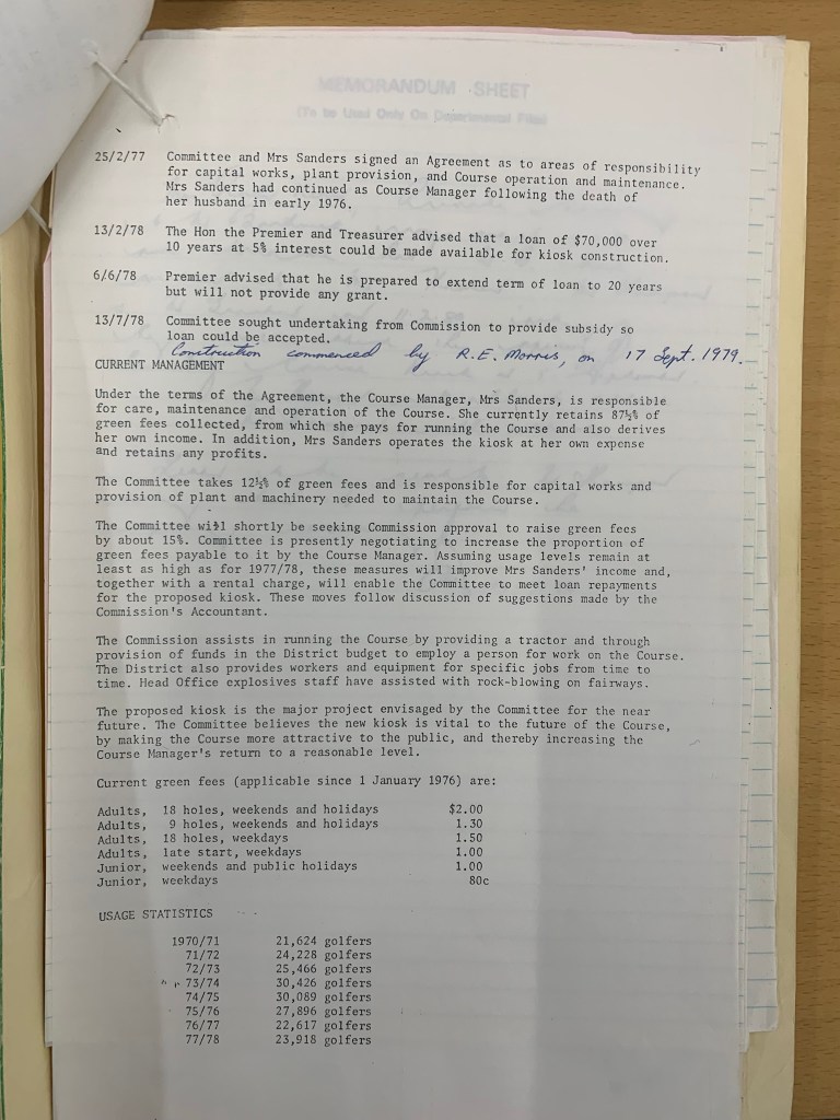
In July 1961, the Committee requested the Forests Commission for provision of a kiosk. In 1966 a temporary kiosk was built. In January 68, new tenants in kiosk, Jim and Pat Sanders, became course “licensees” and were appointed to manage and maintain the course.
From about 1964 onwards, the golf course was set aside as a Special Purposes Reserve and upgraded and extended at considerable expense to the Forests Commission. Pumps and sprinklers were also installed to keep the course green in summer.
After more bushfires in 1968, the Forests Commission entered into a renewed lease with a fledgling Olinda Golf Club.
The extended 18-hole course was opened in April 1970 by the Minister for Forests, Edward Raymond Meagher.
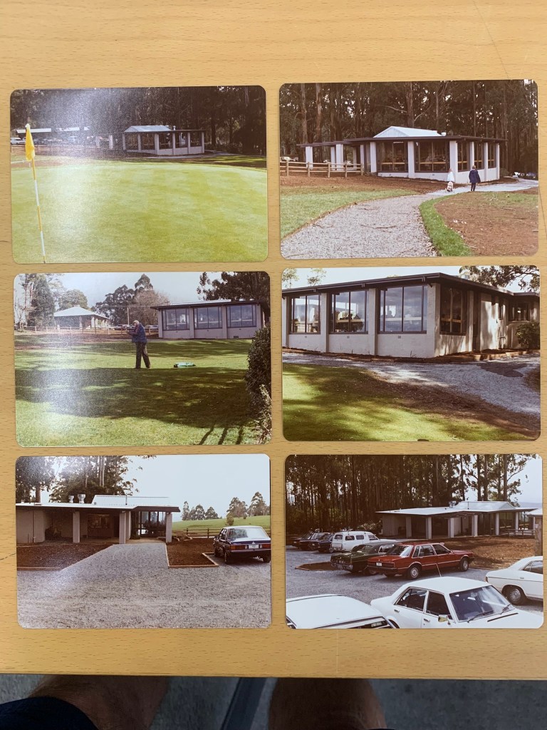
In May 1972 the Olinda Golf Club was given approval by Commission to build a new club house on course. In March 1975, The reserve was reduced to 35 ha with 16 ha added to adjacent Olinda Arboretum.
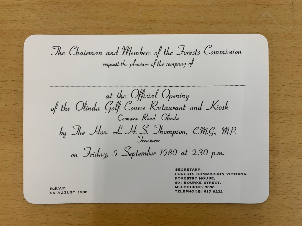
In February 1978, the State Government offered a $70,000 loan to the golf course at 5% interest which enabled it to build much needed facilities and clubrooms including the popular Bide-A-While restaurant which was later opened by Lindsay Thompson in September 1980. An ambitious proposal for a motel was also considered but rejected.
The District Forester from Kallista, Jim Westcott, and later Frank May, sat on the Committee of Management. This was an unusual arrangement. Olinda was the only golf course in Victoria where the Forests Commission took an active role.
The Commission assisted in running the course by providing a tractor and funds in the District budget to employ a person for work on the course. The District also provided crew and equipment for specific jobs from time to time. Head Office explosives staff also assisted with rock-blowing on fairways.
Strategic Firebreak.
In January 1962, there were major bushfires across Melbourne’s outskirts, including the Dandenong Ranges, which killed 33 people and destroyed more than 450 homes. The Olinda township was attacked on three sides and many houses were destroyed and forests burnt. Many people evacuated to the relative safety of the golf course, which was also partially burnt.
The newly established 100-acre National Rhododendron Gardens adjoined the golf course and burned as well. The rhododendron gardens were also on State forest and had been licensed from the Forests Commission in 1960. Most of the mountain ash (Eucalyptus regnans) were killed in the bushfire, and the present trees in the garden and carpark have regrown since that event.
The Forests Commission depot and residence on Chalet Road, occupied by overseer Charlie Chamberlain, was lost when the FCV softwood plantations near Silvan dam exploded in flames.
In the wake of the catastrophic 1962 bushfires there was considerable community outcry. The State Government, with the strong backing of the local MP Bill Borthwick, implemented a long-term buy-back scheme whereby the Forests Commission purchased private land and houses in high fire risk areas, mostly notably on the western face of the Dandenong Ranges.
As part of this planning process, the Dandenong Ranges Fire Prevention Committee (DRFPC) identified the Olinda ridgeline as a critical firebreak and buffer for the town.
Also, after the deadly 1962 bushfires, the DRFPC urged the construction of the nearby Olinda Swimming Pool to act as an emergency fire dam. The 100,000-gallon pool had six fire hydrants to fill CFA and FCV tankers and was located on 5-acres of State forest. The pool was opened by the Minister for Forests, Lindsay Thompson, on 30 December 1964.Furthermore, after a lengthy period of procrastination, community consultation and planning, local Forests Commission crews began replanting the 192 hectares of the old softwood plantation which were burnt below Chalet Road in 1962 with exotic and less-flammable species such as oaks and elms. The area also has a magnificent lookout over the Olinda forest towards Silvan Reservoir and was renamed the R. J. Hamer Arboretum in April 1977.
Importantly, the Olinda Golf Course was strategically positioned on the main ridge. It sat between the R. J. Hamer Arboretum, the swimming pool and the Forests Commission depot in Woolrich Road to the east, and the Olinda Recreation Reserve and the National Rhododendron Gardens to the west. These parcels of public land, all with significant local community use and tourism attraction, had reduced levels of flammable vegetation, and collectively acted as an effective east-west firebreak.
Parks Victoria took over the responsibility for the Olinda golf course in 1989 and issued a new lease, but club membership continued to decline, which was a common pattern among public golf courses across Melbourne. Olinda finally closed in about 2012 and the remaining club members shifted to Emerald.
The State Government announced that the land would not be reinstated as a golf course but set aside for other community uses. The redevelopment of the site has not been without local controversy.
The Olinda pool also closed for a time but reopened after community agitation.
While there are many other golf courses on the edge of small country towns across rural Victoria, which often operate on private land or under a variety of Crown Land leases and occupancy arrangements, the Olinda golf course was a showpiece for the Forests Commission as a unique example of passive fire prevention on State forest, as well as being a valuable asset for the local community.
The 34-hectare Olinda golf course was positioned on a main ridge which adjoined the R. J. Hamer Arboretum and the Forests Commission depot in Woolrich Road to the east. The Olinda Recreation Reserves and the National Rhododendron Gardens were to the west. These parcels of public land collectively acted as a unique east-west strategic firebreak. The Olinda Swimming Pool was also built after the 1962 bushfires as an emergency fire dam. Source: MapShare
Charles George Pettman began working with the Forests Commission in the early 1930s on an unemployment relief program.
About 30 unemployed men came from Melbourne and beyond to their first camp on the old Princes Highway at Burnt Bridge, which was situated on the Toorloo Arm of Lake Tyers in East Gippsland.
There was a hot meal ready when the men arrived, enough kerosine in lanterns for one night, and their beds were two poles on forked sticks and two chaff bags. Clothing, boots and blankets could be purchased from the Commission while food came from Lakes Entrance. The men were paid on a Friday, but 5/8ths of their pay was sent home to their dependants.
The Forests Commission supervising officer was Freddie Kerr and the crew were engaged for three months for silvicultural works such as ring-barking the overmature trees to release the regrowth. Most of the men had never used axes before and blisters were common, but after 3 months there were some good axemen amongst them. They also fought bushfires in the summer and did fuel reduction burning along firebreaks during the autumn.
At the time, the Forests Commission only had rakes, slashers, axes and knapsacks to fight bushfires. There were very few motor vehicles or spotting towers, so the Commission employed fireguards such as Bill Ah Chow and Charlie Pendergast to patrol the bush on horseback to spot fires.
Because there weren’t many roads, fires started by lightning in the mountains meant a lot of walking. So, in the remote high country they were often left to trickle and the cattlemen kept the Commission office informed.
During the war years, Charlie supervised charcoal burning crews near Nowa Nowa. The wood for the kilns was cut from the old ring-barked trees and the charcoal was bagged and transported by train to Melbourne for use in gas-producer cars.
Charlie also helped build Cosstick’s Weir in the Colquhoun State forest in 1945. The weir was used for fire protection and not to fill steam trains as is a common rumour.
After the war, Charlie remained with the Commission building roads in the Irish waterholes area. The thick scrub was first cut with a hand slasher, the trees grubbed out with hand tools and the logs rolled off the road by hand, until blocks and tackle became available. The arrival of bulldozers and graders as well as an ex-army 4WD White Scout Car for transport made the work much easier.
The Nunnett Road was also built by Charlie to open the area for logging, and he later was given the job to supervise the harvesting contractors.
During his career with the Commission, Charlie fought in many major bushfires including the 1965 blaze which burned for several weeks from Lake Glenmaggie to beyond Bruthen.
He retired from the Commission in 1975 and took a role as a guide with Forestours during the holiday period.
Photograph taken in 1935/36 (Source: D Pettman) : Charles Pettman (back row, extreme left with dog) and FCV Employment Relief crew on the Old Buchan Road
Photograph taken in 1935/36 (Source: D Pettman) : Charles Pettman (first standing row, 3rd from right) at an FCV Employment Relief Camp near Burnt Bridge, Toorloo Arm, Lake Tyers
Photograph taken in 1935/36 (Source: D Pettman) : Charles Pettman (front, 3rd from left) at an FCV Employment Relief Camp near Burnt Bridge, Toorloo Arm, Lake Tyers
Photograph taken in 1935/36 (Source: D Pettman) : Charles Pettman (left) – probably near Burnt Bridge, Toorloo Arm, Lake Tyers.
Military training has always been an important activity on Victoria’s State forests and public lands. Probably the most notable example was the takeover of Wilsons Promontory by the commandos in 1941.
Forests were used for both target aiming and live firing. The prominent Lollipop Tree on Mt Beckworth, west of Ballarat, was used by RAAF bomb aimers during WW2.
Manoeuvres by Army Reserve troops are still common.
Unexploded Ordnance (UXO) occasionally turns up in the bush. It ranges from small rifle shells and casings through to practice hand grenades and larger mortars and rockets.
There are many epic stories of departmental staff encountering dangerous UXOs during the handover of Point Nepean from the Army to become a National Park in the 1980s.
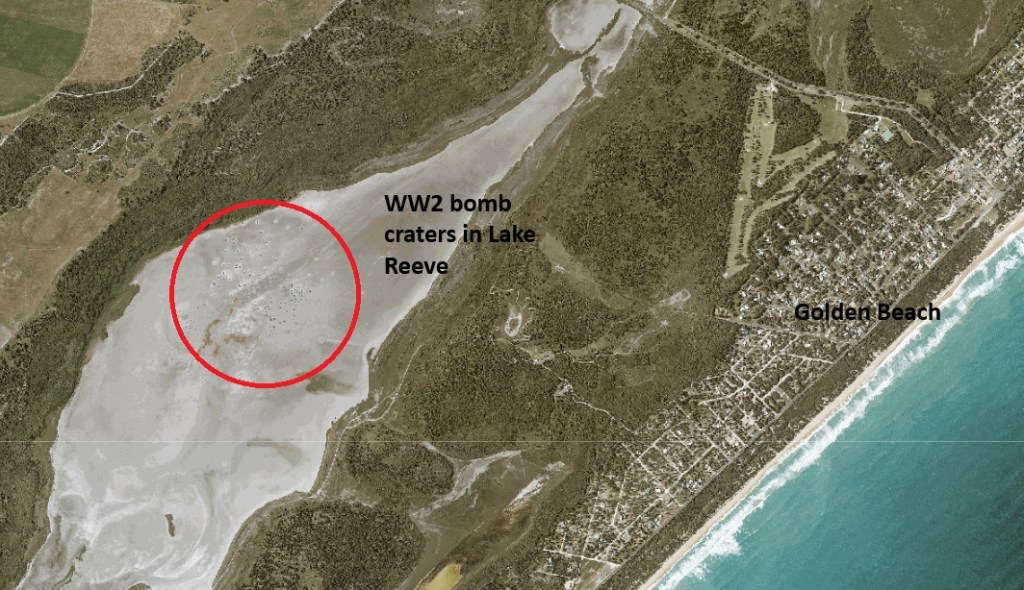
Bomb craters are still visible in the shallow mudflats of Lake Reeve near the 90 Mile Beach and scrub fires in the nearby Dutson bombing range can also be very problematic.
Not surprisingly, UXOs are most likely to be found around existing military bases. The land at Puckapunyal had become severely degraded because of prolonged use by the military and in the early 1970s a major soil stabilisation and revegetation program began. The Soil Conservation Authority took the lead role while the Forests Commission provided trees from its nurseries as well as planting crews.
In May 1989, a group of seven employees were planting trees on the Puckapunyal base near Tehans Hill and lit a small fire to keep warm. But the fire was on top of an old 105mm anti-tank shell buried in the ground which exploded seriously injuring the men, one critically.
On 5 April 1958, a fire was reported about 5 miles northwest of Wandilo, which is not far from Mt Gambier and the Victorian – South Australian border.
The Bluff firetower reported light smoke at 08.25 am on Saturday morning and by 11.40 am the fire was moving quickly and out of control.
It had been a dry autumn and the fire, which began in a dry swamp of dense t-tree, was fanned by strong winds, quickly spread into a mixture of native forest and pine plantations.
The cause of the fire was never officially determined, although most suspected it had escaped after someone was burning off on private land near an old disused railway line.
By midday the temperature reached 92 degrees Fahrenheit, and the Relative Humidity at Mt Gambier Airport dropped to 29% as a fire storm developed under a 40-mph north westerly wind. The FFDI was 33 (Very High).
As the conditions worsened, the fire began crowning through the pines and throwing spot fires up to 20-30 chains (600 m) ahead of the main front as it crossed Earls Road near the disused Medhurst railway station.
Several trucks with firefighters from the Department of Woods and Forests had been dispatched and they entered an east-west firebreak between two blocks in the pine plantation. The adjoining Pinus radiata and Pinus pinaster stands were about 24 years old and un-pruned.
Around 3.00 pm the firefighting crews were caught unprepared in a junction zone as two flanks of the fire passed over them and then swirled back to join.
Two forestry trucks became bogged in soft sand when trying to evacuate while another damaged a gearbox and could not move, leaving 11 men to take cover in their vehicles.
Eight men died. The youngest was only 16.
– Remo Quaggiato
– Charles Dolling
– Bertram Wilson
– Victor Fensom
– Maurice Treloar
– Francis Burdett
– Walter Pearce
– Bernadus Damhuis
Three remaining men survived with moderate burns. Two sheltered in the cab of one of the trucks and emerged safely after the intensity of the bushfire had subsided even though their vehicle was well alight. One man survived by sheltering in a deep sandy wheel rut and covering his face with his coat.
Another party of men narrowly escaped as they drove their truck to safety pursued by roaring flames. The heat was so intense that the clothing of several of the men on the truck caught fire.
The Mount Gambier fire service received its first indication of the tragedy when it heard an emergency “mayday” call over the two-way radio. Grim-faced crews gathered around heard a dramatic call for “Police, a doctor and a priest.”
The 3300-acre fire was brought under control early the next day.
A public outcry followed, and the inquest found the men had been failed by their equipment, with vehicle fuel lines vaporising in the heat and truck cabins ill-equipped for survival situations. Firefighting tactics and equipment changed after the tragedy.
The Wandilo fire occurred at a time when bushfire behaviour research in Australia was in its infancy and years before methods were available to fire managers to quantitatively assess fire potential.
The legendary CSIRO fire scientist, Alan McArthur, published a review of the Wandilo fire later in 1966. It became a benchmark in understanding fire behaviour in pine plantations.
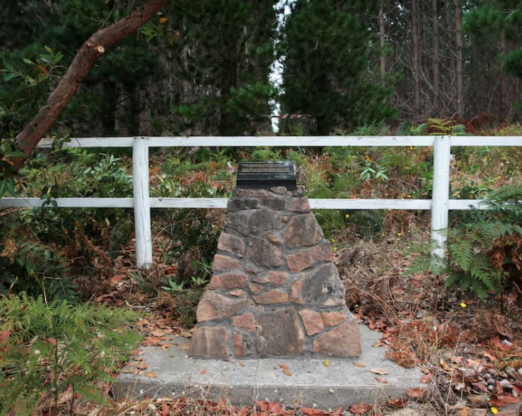
A small memorial marking the site of one of South Australia’s most tragic bushfire disasters sits in the midst of tall radiata pine trees, largely hidden away from public view.
Phyllis Bromby was born on 10 April 1888 in Armadale as the daughter of Edward Hippius Bromby and Jane Nodin.
The Bromby’s were a well-educated, middle-class family living in early colonial Melbourne which brought many important social and professional connections. Her father was the first librarian of the University of Melbourne, and her grandfather, The Rev. John Bromby, was the founding Headmaster of Melbourne Grammar.
Sadly, Edward’s wife Jane, and their ten-year-old daughter Dorothea, both died within six months of each other in 1888. So, at the age of 41, Edward became a widowed father with two sons and a baby daughter, Phyllis.
However, his appointed at Melbourne University brought stability into Edward’s life and he later remarried Edith Browne in 1892 and moved to Heidelberg.
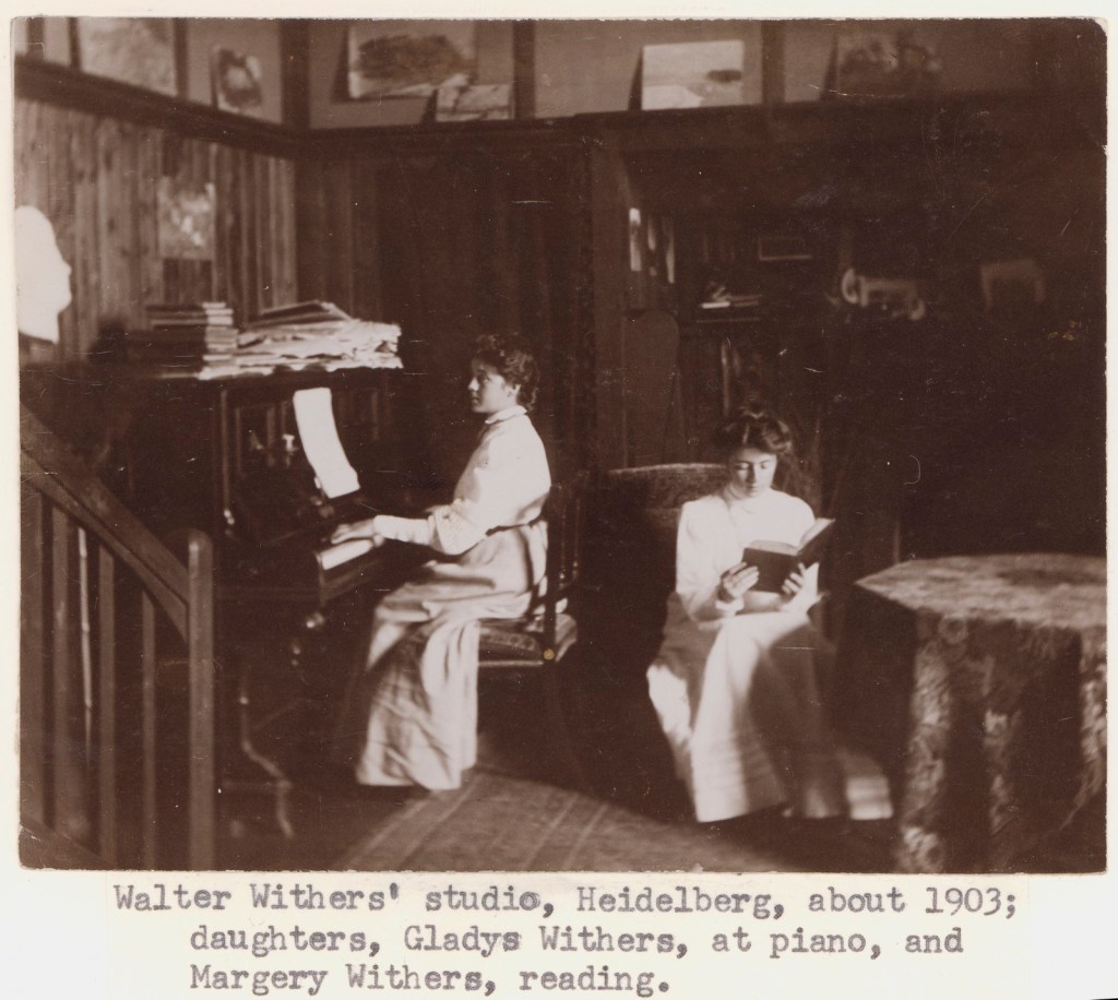
The prominent Melbourne landscape artist Walter Withers and his family also settled in Heidelberg and his daughters, Gladys and Margery, became close friends with Phyllis, a keen photographer who documented family life.
Earlier in about 1874 Edward had taken up a selection of land at Gembrook, which served as a retreat for his family. They also had the means to travel, and Phyllis continued to photograph her many adventures including forest scenes in the Dandenong Ranges. Some of her famous photos are in the State Library.
Phyllis died on 16 July 1978 in East Malvern, aged 90.
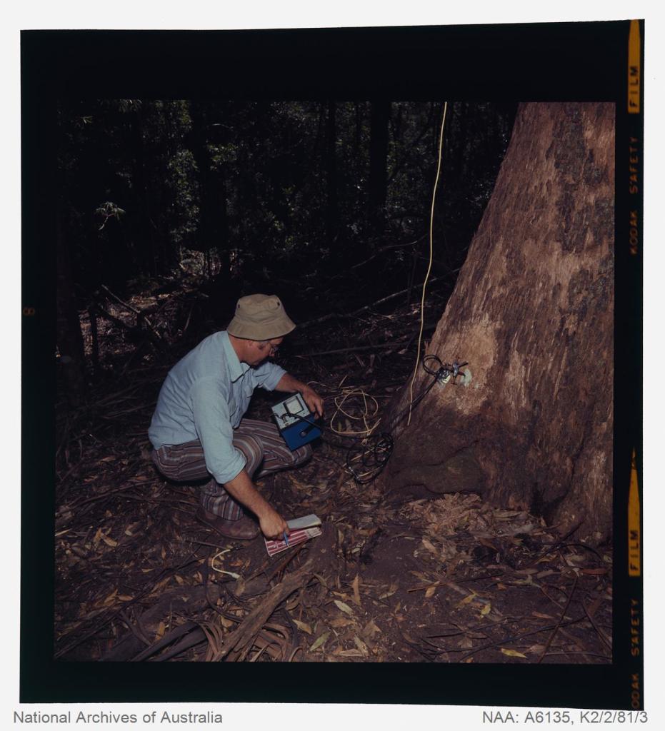
Lightning is one of the major causes of bushfires, particularly in the remote mountains.
This lightning detector system was developed by Dr. Peter Kourtz at Canada’s forest fire research institute. By 1977, some 300 were in use across the country.
The small mushroom antenna could detect short-range (20-mile) changes in electrostatic field associated with lightning strikes. It needed to be placed out in the open on a hilltop and away from nearby trees.
It simply counted the number of “strikes”.
The detector doesn’t seem to have a direction finding capability or be able to distinguish between cloud-to-cloud or cloud-to-ground lightning.
It’s not sure how this particular unit found its way to Victoria.
The Bureau of Meteorology’s (BOM) current lightning detector network uses radio waves emitted by lightning to pinpoint the location of lightning strikes. The network is operated by a private company that sends data to the BOM in real time.
Lightning detection systems use sensors like antennas, GPS receivers, and processing systems to detect radio waves, also known as sferics. The systems calculate the lightning’s location and speed by measuring how long it takes for the radio signal to reach the different antenna stations.
The BOM also has a Thunderstorm Tracker that uses weather radar data to identify areas of potential thunderstorm activity. The tracker updates every six minutes and shows the direction thunderstorms are moving, as well as their expected position in 10, 20, and 30 minutes
During August and September 2000, a total of 97 firefighting specialists from Australia and New Zealand were deployed to America.
This was the first time that a large number of operational firefighters had travelled from Australia and NZ to help their north American colleagues.
During the northern summer of 2000, America experienced one of its worst wildfire seasons. The situation was made worse by a long drought, severe fire weather and dry lightning storms which started thousands of new fires throughout the northern Rockies, into southern Idaho, Montana, Utah, Nevada and into the Sierra-Nevadas.
By early August 2000, over 15,000 firefighters from both America and Canada were fully committed, together with 700 tankers and 150 aircraft.
Conditions were expected to get worse and many fire experts thought it had the potential to rival the disastrous wildfires of 1910, which were on a scale similar to the 1939 Black Friday bushfires in Victoria.
It developed into a long and gruelling campaign, with crews engaged continuously for many months. By early August, all available forest fire control staff were either on a rotation or committed. There was nothing, or nobody, left to call. Many fires in remote locations were simply left to burn unattended.
Towards the end of October, nearly 86,000 fires had burned about three million hectares of land, destroyed hundreds of homes and structures and caused 16 deaths, including 12 firefighters.
Australasian Inter-Service Incident Management System (AIIMS).
Seventeen years earlier, in July 1983, only a few months after the catastrophic Ash Wednesday bushfires, the Forests Commission Victoria (FCV) ran a three-day staff workshop to review the bushfire season.
The formation of the Department of Conservation, Forests, and Lands (CFL) had only just been announced at the time of the meeting.
Speakers at the workshop addressed a wide range of issues and formulated actions on crew safety, management of resources, firefighting tactics, shift changes, equipment, skills training, communications, liaison with other agencies, logistics, use of aircraft for reconnaissance and firebombing, as well as weather and fire behaviour forecasting.
Included in the review was improving command-and-control arrangements at large bushfires.
Traditionally, District Foresters were responsible for any fire on State forests and National Parks and took overall control as “Fireboss”. It was an entirely normal arrangement to have a senior FCV Fireboss in the field directing operations.
While it had its advantages, the Fireboss role based in the field had some serious shortcomings too, particularly if the fire escalated or became fast moving and complex.
In Victoria, the Country Fire Authority (CFA), who are mostly volunteers, are responsible for bushfires on private land and operated independently from the FCV on separate radio frequencies and under a well-entrenched and familiar group structure.
Cross agency issues sometimes arose within the interfaces or “marginal mile”; so FCV and CFA liaison officers were appointed for joint incidents. This arrangement worked well enough for small events but was quickly overwhelmed during large and complex bushfires.
The Forests Commission had begun experimenting with new fire control arrangements from the mid-1970s based on shared experiences and long-standing relationships with the US Forest Service.
Different control arrangements had been trialled at Cann River and Warburton during the 1983 Ash Wednesday bushfires.
Following the 1983 review, the Forests Commission consciously shifted its approach to suppression of large fires on Victoria’s State forests and National Parks.
During 1984, Kevin Monk from the FCV’s Fire Protection Branch travelled on a Churchill Fellowship to California to study the United States National Incident Management System (NIMS). He brought back the NIMS documentation and developed a unique Victorian version, which became known as the Large Fire Organisation (LFO). Importantly, the LFO was designed to be scalable; from Level 1 for simple local incidents, through to Level 3 for complex multi-agency and campaign bushfires.
By the summer of 1984-85, the LFO was being progressively adopted with the establishment of dedicated Incident Management Teams (IMTs) complete with Incident Controllers, Operations, Planning and Logistics units. Staff were identified and trained within the new regions of Conservation, Forests, and Lands (CFL).
Athol Hodgson was appointed CFL’s first Chief Fire Officer (1984-87) and was a strong advocate for the new emergency arrangements. In 1984, he led a high-level delegation of Australian bushfire controllers on a study tour to the USA and Canada. Brian Potter, Chief of the CFA (1985-91), was on the tour.
The bushfires of January 1985 in the alps which occurred from Mt Buffalo to Mt Selwyn, were the first major test for the newly formed Department of CFL. It was also the largest deployment of firefighting aircraft in Australia up to that time, including 20 helicopters and 16 fixed-wing aircraft from the FCV, Australian Defence Force and National Safety Council of Australia (NSCA). The LFO was given a thorough test run at these fires.
Later Chief Fire Officers, Barry Johnston (1987-90), Rod Incoll (1990-96) and Gary Morgan (1996-2005) maintained the momentum for changes to command-and-control arrangements at large bushfires in Victoria.
Significantly, in 1986, the Victorian Emergency Management Act provided for a single controller to be appointed for each joint CFA/CFL bushfire.
Later in 1988 the Australian Association of Rural Fire Authorities adopted the principals embodied in LFO and NIMS.
The LFO became the forerunner of the Australasian Inter-Service Incident Management System (AIIMS) which was adopted nationally in the early 1990s under the newly formed Australasian Fire Authorities Council (AFAC) representing all Australian and New Zealand fire services, and land management agencies with fire responsibilities.
AIIMS was jointly adopted by the CFA and CFL in 1991 with the intent of bringing emergency services together under one control system with common terminology.
An Agreement was signed by the Chief Officers of the CFA and NRE (formerly CFL) on 14 November 1997 to give more detail on joint firefighting arrangements.
In addition to NRE, there were a couple of advocates, but it’s also fair to say there was strong resistance from some quarters to shifting from entrenched arrangements and adopting AIIMS, and it took many years to make the full transition for some agencies and jurisdictions.
The operation, training and slow uptake of AIIMS by the CFA were some of the key issues identified at the Coronial Inquest into the deaths of five CFA firefighters at Linton in December 1998.
After the Linton findings, Gary Morgan, the Chief Fire Officer of the Victorian Department of Natural Resources (NRE), and Richard Rawson, Director of the Forest Service, were strong advocates and eventually persuasive that all CFA volunteer forest fighters should undertake compulsory minimum skills training. They also urged the CFA to move away from its established group structure at fires involving both organisations.
The 2000 deployment.
The relationship between Australia and particularly Victorian forest firefighters and their north American counterparts was strong. Over many decades there had been high-level delegations and study tours to the US from Australia, and vice versa. The innovation and joint development of worldclass fire equipment at the Altona workshops and at Boise in Idaho is just one example.
After midnight on 3rd August 2000, Gary Morgan, was contacted by Rick Gale from the American Department of Interior asking for his help. This was a personal request from Rick resulting from a strong relationship forged after Gary’s earlier trip to make a keynote presentation in Canada.
Four days later, Tony Edgar, NRE’s Gippsland Regional Manager from Victoria, and Murray Dudfield from New Zealand, arrived at the National Inter-Agency Fire Centre (NIFC) in Boise Idaho to assess the need and offer the type of support that Australia and New Zealand could provide.
A formal request was then made through the American Embassy in Canberra to the Australian Department of Foreign Affairs and Trade.
The fire situation in America was urgent and things moved at breakneck speed, and by 10 August a new and unprecedented high-level agreement was signed with the Americans by Gary Morgan and the NRE Secretary, Chloe Munro, on behalf of all Australian and NZ fire agencies.
A taskforce of 79 experienced firefighters was hurriedly assembled and mobilised the very next day on 11 August 2000. They included field operations, aviation, IMT and logistics specialists.
Air travel, accommodation, passports and immigration clearance were mostly handled by NRE. Other essential requirements included passing a medical examination and a fitness assessment. The US embassy arranged a waiver of the normal visa arrangements for the incoming firefighters
All the firefighters needed to have AIIMS accreditation, so most were drawn from NRE and Parks Victoria where AIIMS had been in use for some time. Others came from New Zealand, Tasmania, NSW and Western Australia. Two personnel from a CFA Industrial Brigade (Myrtleford HVP) and ex NRE firefighters also went.
After orientation, issuing equipment and some training at Boise, the first taskforce was split into three groups and operated across bushfire theatres in Idaho, northwest Montana and southwest Montana.
There were a few hurdles the newcomers needed to quickly adjust to.
Overcoming jetlag,
Slight language, cultural and accent barriers,
Learning some new terminology,
Discovering about fire behaviour in different forest and fuel types.
The sun was in the south at midday and the shadows moved the wrong way,
Remembering old imperial measurements like acres, miles and gallons,
Driving on the wrong side of the road,
Prevalence of firearms,
Using a national radio network,
Stricter discipline during briefings,
Sleeping on the ground in small tents,
The work/rest cycle of 12-hour days and 14-day tours,
Yellow school buses to ferry crews,
The vast scale of the operations,
Smoke jumpers and hotshot crews,
Different hand tools such as the Pulaski, and,
Learning how to deploy fire shelters (shake and bakes).
Despite these minor differences, mutual respect quickly developed, and the Australians and New Zealanders fitted right in, particularly for those familiar with AIIMS.
The first taskforce completed their assignment a month later on 15 September 2000, which included a short mid-tour break.
A second taskforce of 17 aviation and logistics experts was mostly deployed to Missoula in Montana for 21 days from 15 August to 5 September 2000.
Understandably, there had been few “speed bumps” and many lessons were learned, but this first deployment was judged a resounding success. A thorough review by Rick Sneeuwjagt from the Department of Conservation and Land Management (CALM) in Western Australia led to refinements for future exchanges.
The goodwill and gracious hospitality shown to the Australians and NZ firefighters by both US fire staff and the American community during their five-week deployment cemented some lasting personal and professional friendships.
The first reciprocal deployment to Australia of north American firefighters and Incident Management Teams was in early 2003 to the major alpine fires in eastern Victoria. This was also the first time that the Kiwis had helped in Victoria.
Without doubt, the common terminology and compatibility between AIIMS and American Incident Management Systems ensured smooth operations and interchange of staff.
Exchanges of Australian and NZ firefighters across the hemispheres are now regular and routine, but they were only made possible by the pioneering work done by the Forests Commission during the 1980s to develop AIIMS and continually advocate for its adoption across Australia, and across the ditch.
Thank you to those who contributed to this story including Gary Morgan, Tony Edgar, Peter West, Peter Ford, Lex Wade, Geoff Pike and Mike Leonard.
Source: Peter West
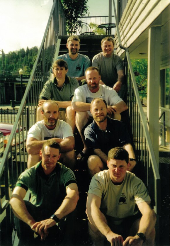
From Back. Richard Bourke, Glen Mawson, Peter West, Grange Jephcott, Ion Worrell, Denis Mathews, Scott Armstrong, Shaun Lawlor. At Coeur d’Alene in Idaho. Source: Peter West
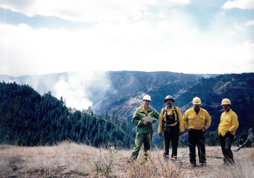
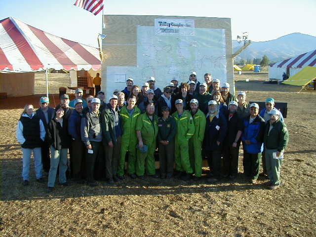
Valley Complex. Source: Peter WestBlackfeet Crew. Source: Peter West
Valley Complex. Source: Peter West
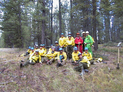
Northern Rockies Fires Aviation Group in Missoula. Front row: Leith Mckenzie, Mike Fitzgerald, Hayden Biggs, Jan Radic, John Appleby (Wombat), Rob Jarvis Back row: Colin Smith, Stephen Walls, Paul McDiarmid, Jim Whelan, Richard Alder, Bryan Rees. Andrew Matthews and Peter Cuthbertson remained in Boise to with the line scanners and Barry Marsden stayed with the equipment cache. Photo: Stephen Walls, CFA
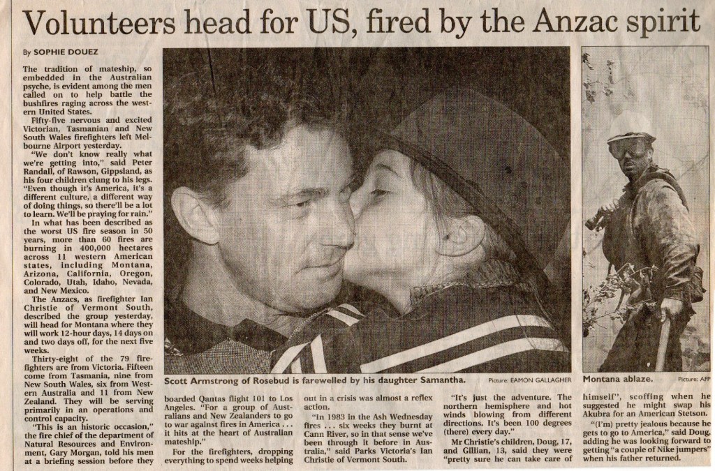
The Age, 12 August 2000. Source: Peter West
The AIIMS movers-and-shakers. The Chief Fire Officers. L-R: Athol Hodgson (1984-87), Stan Duncan (1980-84), Rod Incoll (1990-96), Gary Morgan (1996-2005), Barry Johnson (1987-1990). Source: FCRPA Collection.
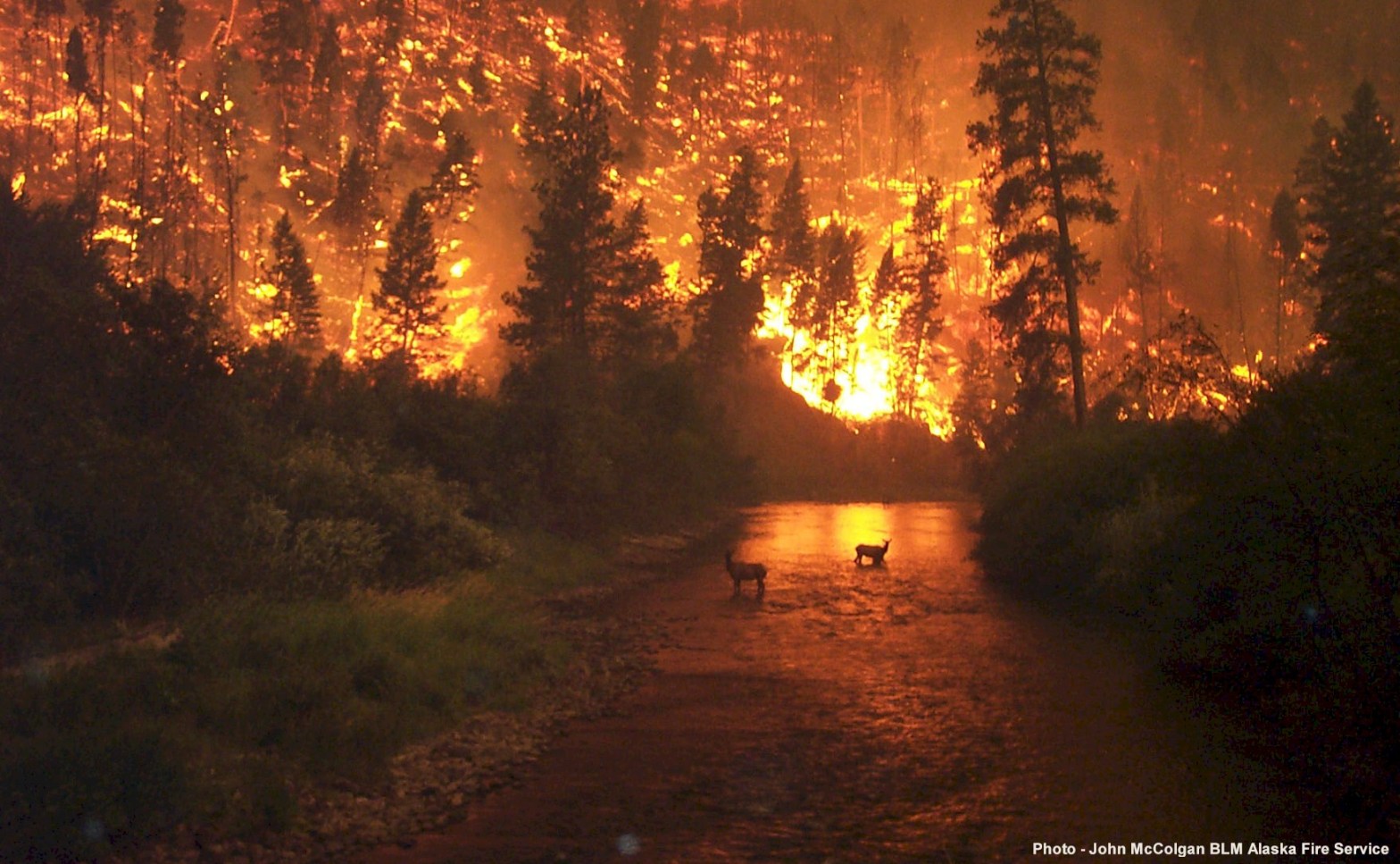
Bitterroot National Forest in Montana on August 6, 2000. Photo taken by John McColgan a fire behaviour analyst from Fairbanks, Alaska.
This contraption is thought to have been developed in the FCV radio workshops at Surrey Hills.
It’s basically a STC vehicle radio which has been mounted on a backpack frame and powered by a heavy lead-acid battery.
The backpack frame was manufactured at the Altona fire equipment development centre. A considerable number of these radio units were made and distributed to the field.
One of the quirkier items in the DEECA Altona Museum Collection. 24 A/110.
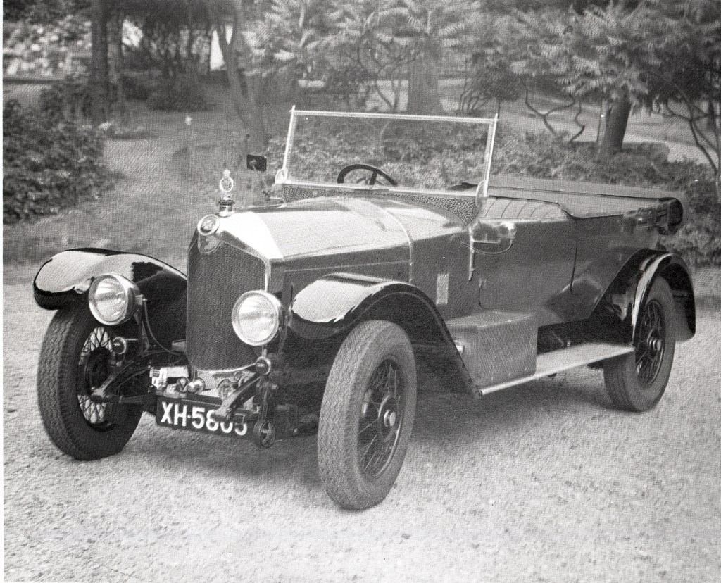
I have no idea what sort of car this is, or what year these photos were taken, but this impressive motor is thought to have belonged to Hugh Robert Mackay.
Mackay had been Secretary to the Royal Commission into forests between 1897 and 1901. He had compiled its reports and later drafted the Bill on which the 1907 Forest Act was based.
He was subsequently appointed as the first Conservator of the new State Forest Department (SFD) in 1907 and remained until the formation of the Forests Commission Victoria (FCV) in 1919 when Owen Jones was recruited from England.
This snazzy car was thought to have been used in his travels around Victoria.
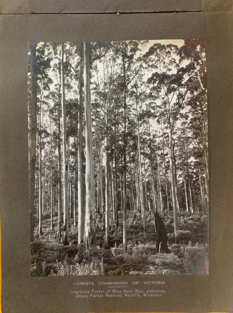
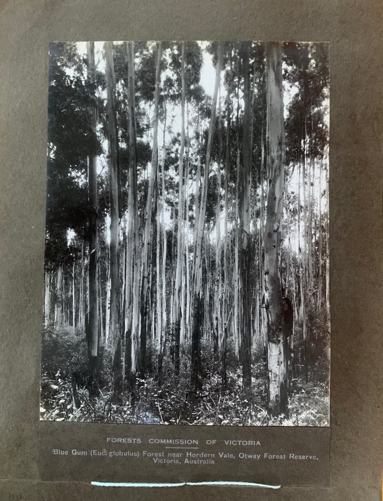
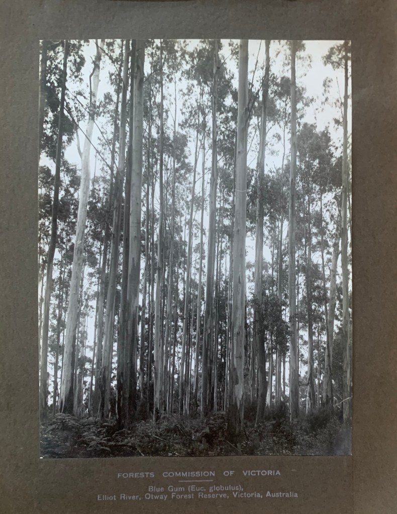
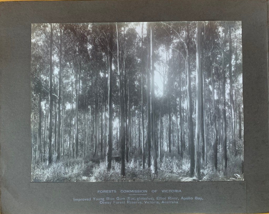
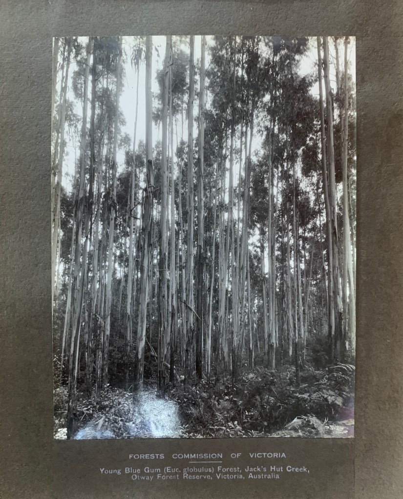
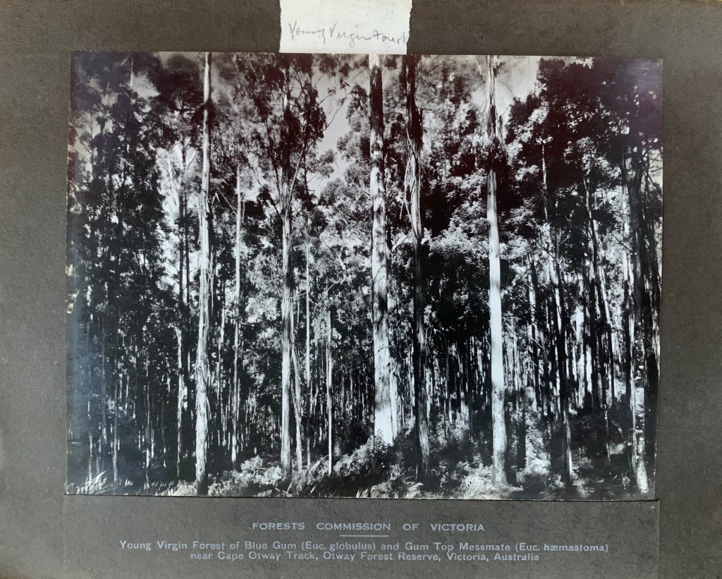
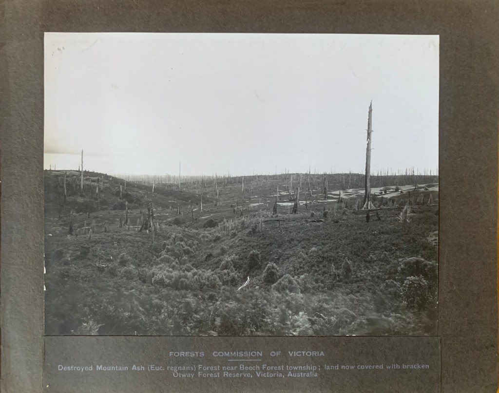
This nice little find comes from the Public Record Office. It’s a small photo album of the Otways forests from the early 1920s.
My guess is that it was produced during a major stoush between the Forests Commission, sawmillers, and the community against the Lands Department trying to alienate (sell) more forest in the western Otways.
The foresters eventually won, but there were casualties. The newly appointed Chairman of the Commission, Owen Jones, quit in disgust and went to new Zealand.
The land eventually became the Otways National Park.
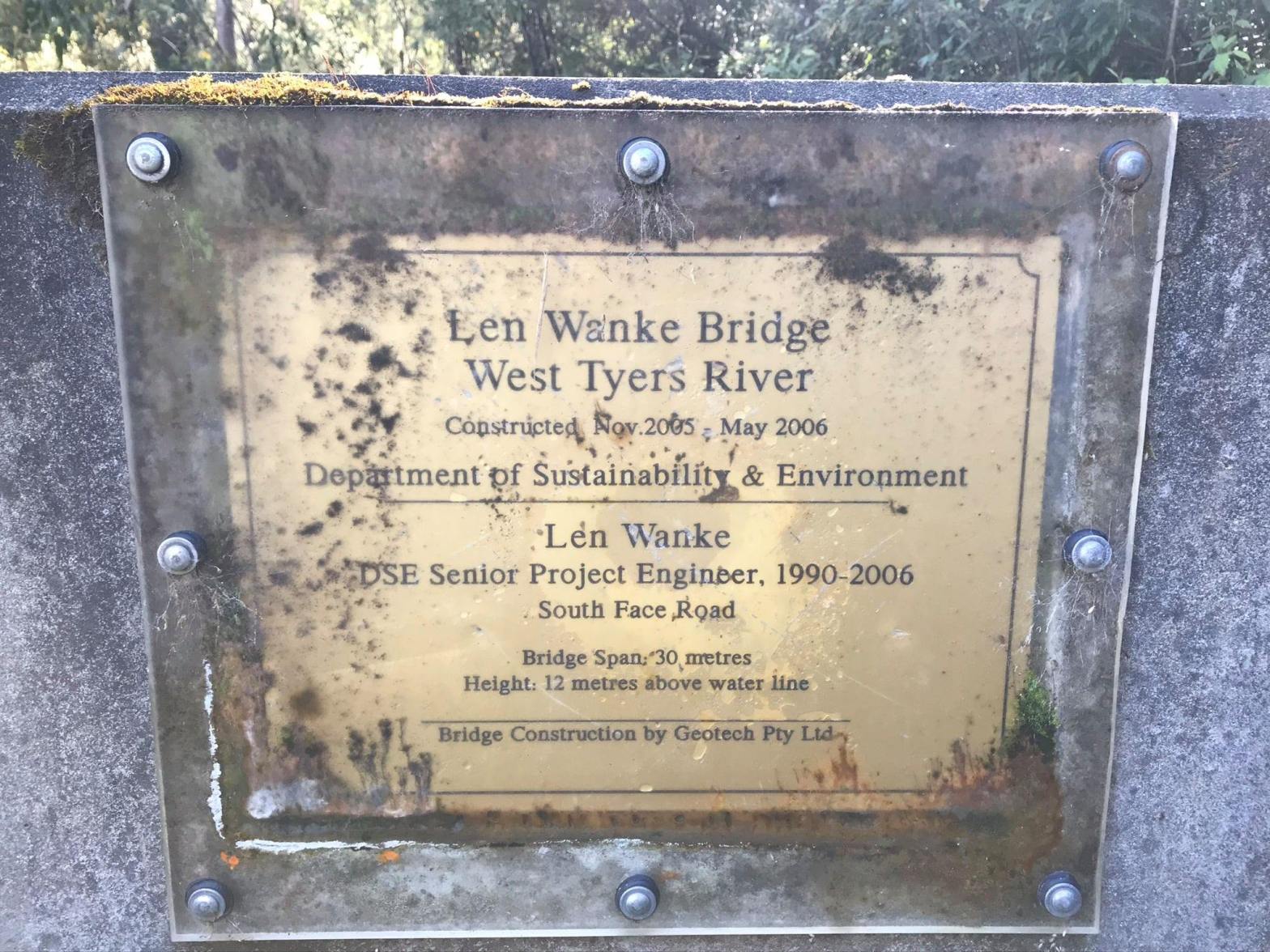
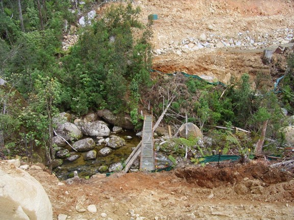
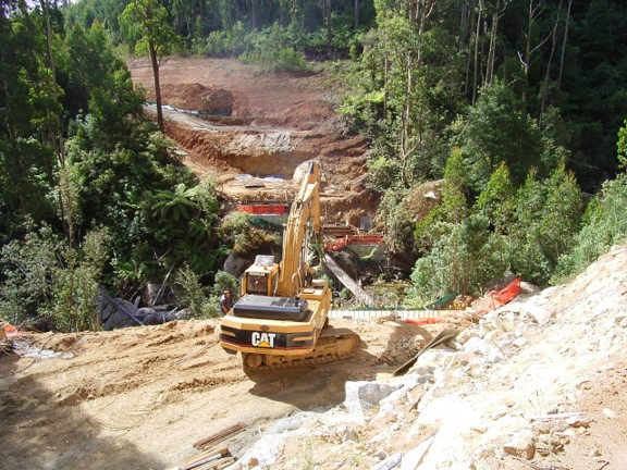
The South Face Road (SFR) climbs steadily for 25 km, in an east-west direction, across the southern slopes of the Baw Baw Ranges in Central Gippsland.
It links the Thomson Valley Road in the east to the Baw Baw Tourist Road in the west.
The South Face Road was without doubt the biggest and most complex road construction project that the Department had undertaken since the heady days in the late 1950s when the Forests Commission built the Tamboritha and Moroka Roads into the mountains beyond Licola.
It took 20 years to build at a direct cost of $25 M.
The entire design and construction project was managed in-house by the Department of Natural Resources and Environment with Len Wanke as the Chief Engineer and Wayne Beaton assisting.
The ground was steep with highly erodible soils and strewn with large granite boulders and the route included several major river crossings.
Major earth moving and side cuts were required because the road alignment ran across the side slope of the Baw Baw Ranges.
The thick mountain ash forests were wet, and it often snowed in winter, so earth works only progressed over the short summer months.
There were also many biodiversity values to protect including streams, rainforests and Baw Baw frog habitat.
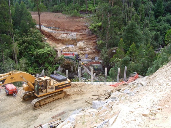
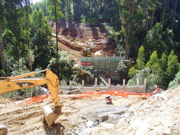
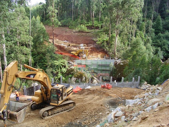
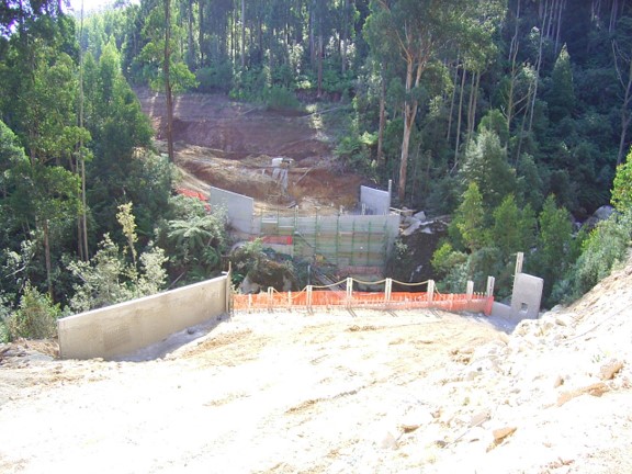
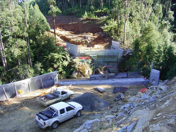
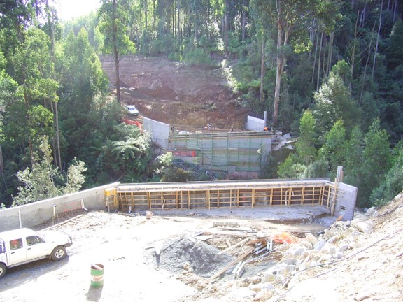
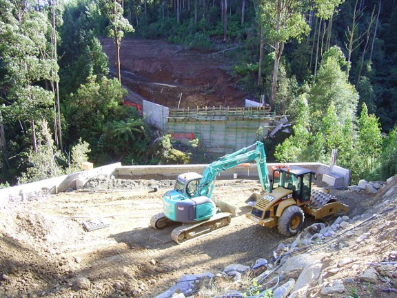
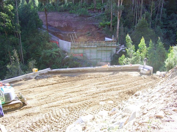
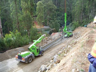
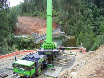
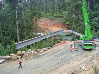
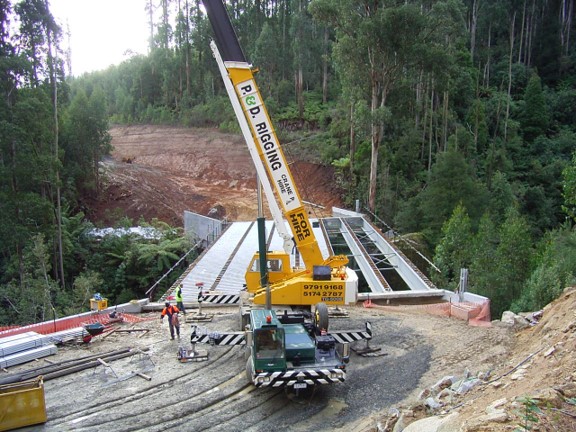
The major engineering obstacle was the bridge over the West Branch of Tyers River. It took six months build between late 2005 and mid-2006 and cost $1.5M. This series of photographs was taken by Peter West, the forester in charge of the project from Erica.
Now that the construction scars have healed the South Face Road is a very scenic drive through these magnificent wet forests. This is an obvious bonus for tourism at the Baw Baw snowfields at one end, and the settlement of Walhalla at the other.
The road was funded by the timber industry so it’s hard to imagine another project of this magnitude ever being undertaken again.
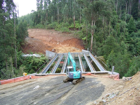
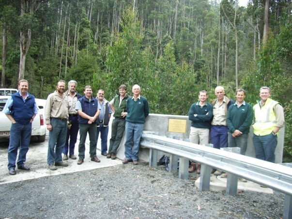
21 Nov 20055 Dec 200520 Dec 200517 Jan 200619 Jan 20067 Feb 200614 Feb 20061 March 200616 March 200620 March 200624 March 200624 March 20063 April 20066 April 200612 April 200627 April 20062 May 20065 May 20069 May 20069 May 200617 May 200617 May 200624 May 200624 May 200624 May 200624 May 200625 May 200629 May 20065 June 20066 June 200614 June 2006Len Wanke Bridge over the West Branch of the Tyers River.
Len Wanke Bridge over the West Branch of the Tyers River. Grange Jephcott, Phil Ripper, Peter McEwan, Ross Pridgeon, ?, Peter West, Len Wanke, Wayne Beaton, Pat Dowling, Martin Slate, Andy Channon. 2006 Source: Peter West
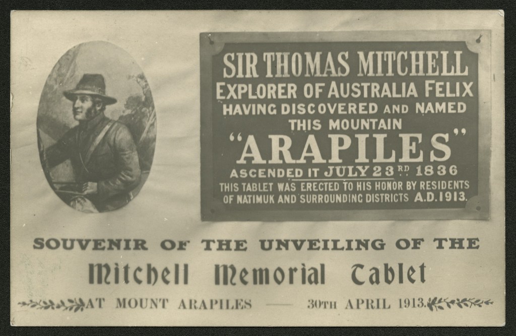
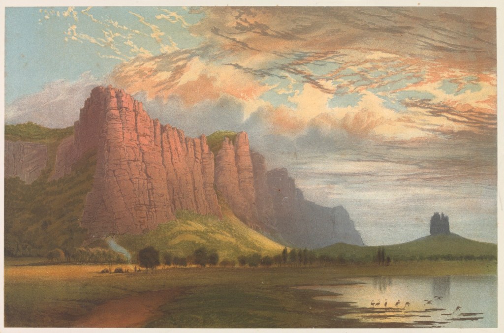
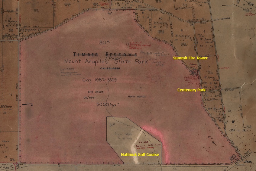
Mount Arapiles is an isolated sandstone outcrop near Horsham which rises 460 feet above the flat Wimmera plains.
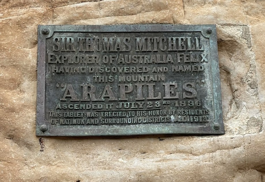
The first European to see the mountain was Major Thomas Mitchell during his epic overland trek in 1836.
He named the landmark on 23 July 1836 after the Arapiles Hills near Salamanca in Spain. Mitchell had seen action as an Army Officer in the Battle of Salamanca during the Peninsular Wars in July 1812. An extract from Mitchell’s diary reads:
“I ascended this hill on the anniversary of the battle of Salamanca, and hence the name.”
When squatters moved into the area during the early 1840s, Mt Arapiles was included in the Vectis Run, which was taken up by the Wilson Brothers in 1844.
By the early 1870s, selectors had moved into the Wimmera from Hamilton and from across the SA border. Those that selected in the vicinity of Mt Arapiles were probably the first to use the area for recreation.
In 1897, Mount Arapiles was first gazetted as a 4653-acre Timber Reserve under the Land Act (1892) and then again under the new Forests Act of 1907.
In 1912, the Shire Council of Arapiles, which was formed in 1888, requested 18 acres of the Timber Reserve be excised and set aside for recreation. This was a unique request, and it became the first area of Reserved Forest to be formally set aside under the Forests Act (1907) for “natural beauty and interest”.
There were only a couple of options open to the Forests Commission under the legislation at the time.
Section 16 provided for the excision of land from permanent forest, “…. which may be required for public use as mineral or medicinal springs, or for reservation for visitors to any waterfalls, caves or places of natural beauty or interest, or as health resorts ….”
Section 24 provided for various types of leases, one of which was: “…. the Governor in Council may grant to any person for any term not exceeding seven years a lease of any Crown land within any reserved forest”.
The second option was adopted, and permissive occupancy was granted over 18 acres. But there was no provision in the 1907 legislation for the appointment of a Committee of Management and it had to wait until the Forests Act of 1918 before a legal committee could be formed.
Facility development and maintenance was undertaken by the Arapiles Shire Council and the Natimuk Progress Association. A memorial tablet was unveiled in April 1913 to mark Major Mitchell having climbed and named the mountain in 1836.
In May 1933, the Arapiles Shire Council discussed the Centenary celebrations which were being planned for Victoria in 1935. These celebrations were to commemorate the 100th anniversary of the arrival of the first settlers in Victoria. It was suggested that a special stone gateway be erected at Mt Arapiles.
But it was decided to defer the celebrations until July 1936 to mark 100 years since Mitchell’s ascent of Mount Arapiles.
The Natimuk Progress Association sought approval from the Forests Commission to erect the gateway, to build a shelter shed and toilets and to plant trees in the reserve. The Association also indicated that they wished to name the picnic ground – Centenary Park. Other names such as Major Mitchell Park were considered.
The Forests Commission agreed and requested that a new list of nominees be forwarded so that a committee of management could be formed. They included L. Lang, R. E. Sudholz, R. G. McClure, A. G. Sudholz, G. Grant, H. Woolmer and A. W. Lockwood.
The official opening of the gates at Centenary Park on 23 July 1936 was a huge and festive event. The Horsham Times estimated the crowd at 3,000 and commented:
“It was a red-letter day in the Wimmera and attracted one of the largest crowds at a country function for years.”
The Melbourne Argus reported on 24 July 1936:
Advantage was taken of the opportunity which the centenary provided to establish what has been named Arapiles Centenary Park, comprising 18 acres granted by the Forests Commission.
One of the two larger pillars bears the inscription “Arapiles Centenary Park ” and the other ” To Commemorate the 100th Anniversary of the Discovery of the Mount”
Councillor R E Sudholz, president of the celebration committee, introduced Mr Scholfield, MHR, Mr Lamb MLA, Councillor P J Wilmoth (Major of Horsham), Councillor E Zerbst (president of the Arapiles Shire), Councillor L Ryan (president of the Kowree Shire), Councillor Smith (Wimmera Shire), Mr J W Gray (representing the Education Department), Mr A S Kenyon (representing the Historical Society, Anthropological Society and Field Naturalists) and Mr J E Menadue (Horsham High School), representing the Australian Natives Association.
The official opening of the gates was performed by Mr A W Lockwood, secretary of the celebration committee.
The discovery of the mount was re-enacted by a pageant, Mr F Woolcock impersonating Major Mitchell, accompanied by 25 horsemen.
The memorial gates are still there along with a few old pine trees in the campground.
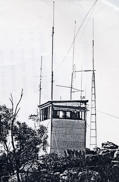
The Country Roads Board (CRB) built many of the major roads at Mt Arapiles in 1938 and the Forests Commission built a firetower on the summit in about 1955.
In the late 1950s, the Forests Commission used provisions in Section 50 of the Forest Act (1958) to set aside areas as Special Purpose Reserves. They included the 18-acre Centenary Park, along with a new 40-acre wildflower reserve to protect fairy wax flower, and another 40-acre picnic ground. The 18-hole Natimuk golf course was also licenced in the southern part of the Timber Reserve.
Mt Arapiles became popular for recreational rock climbing from the early-1960s and is now one of the premier climbing sites in Australia.
The Timber Reserve passed from the Forests Commission into the Mt Arapiles – Tooan State Park after the Land Conservation Council (LCC) made its final recommendations in 1982. The land was permanently reserved under the Crown Land (Reserves) Act and managed by the National Parks Service (now Parks Victoria).
It’s believed that the Shire relinquished its responsibilities over the small 18-acre Centenary Park in the mid-1980s.
Mt Arapiles is just one of many areas of State forest across Victoria which were originally set aside as Timber Reserves and are now seen as worthy of being declared National and State Parks. Sherbrooke Forest in the Dandenong Ranges is another notable example.
Source: Tony Willett, Victorian State Foresters Association Newsletter No 48. December 1980.
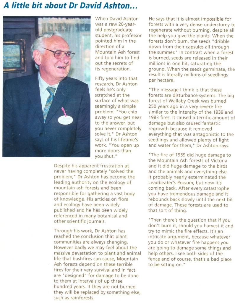
This small memorial plaque overlooks the Toororrong Reservoir north of Melbourne and commemorates Dr. David Ashton.
David was unquestionably the world expert on the ecology of mountain ash forests (Eucalyptus regnans).
He was born in Melbourne in 1927 and received a Bachelor of Science in 1949, and a PhD later in 1957.
In 1949, David initiated a 50-year experiment in the Wallaby Creek Catchment after parts of the mountain ash forests had been severely burnt, killed and then regenerated after the Black Friday fires of 1939.
Some of the oldest trees remaining in Wallaby Creek originated from a bushfire in about 1700, while others regenerated after the great fire of 1851. The forest was burnt once again in the Black Saturday bushfires of 2009.
Along with other foresters and dendrophiles like Murray Cunningham, David discovered the essential role of disturbance by infrequent but intense bushfires in regenerating and renewing these wet mountain forests.
He became an inspiring and passionate teacher for over three decades at the University of Melbourne as Associate Professor of Botany. He undoubtedly influenced several generations of Victorian botanists and foresters… including me…
David received many honours and awards including an Order of Australia (OAM) in 2001 “For service to the science of plant ecology, particularly in the areas of forest regeneration, conservation and management”.
In the early 1990s, a new State Forest Management Planning process was in full swing, and a community advisory committee was appointed by the Minister for Conservation and Environment, Steve Crabb.
The committee for the Yarra Forests was headed by local shire councillor, Gordon Buller, and included representatives from the timber industry, as well as recreation and conservation groups.
Peter Preuss represented the Australian Wildlife Protection Council, while Ron Reid, a local sawmiller from Yarra Junction, represented the timber industry on the committee.
I led the forest planning process at the time, and unsurprisingly there was a strong divergence of views within the advisory committee which occasionally flared up but overall, there was a genuine willingness to listen and work together.
Peter was a school teacher in Yarra Junction and particularly active in the long-running campaign to stop logging and create a large National Park in the Central Highlands. He produced his own “Have Your Say” booklet on the forest planning process in conjunction with other conservation groups. It even included a self-guided forest drive around the bush. The Department was not consulted nor involved in its production.
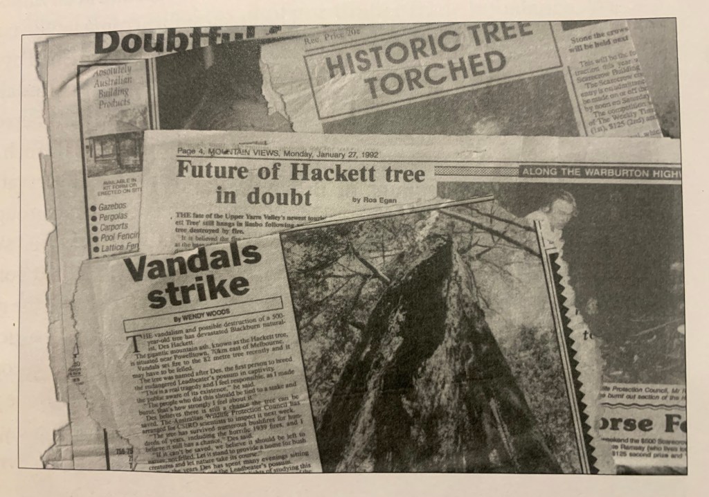
Meanwhile, Leadbeater’s possum had become a symbolic emblem of the forest conservation movement, particularly when it was rediscovered near Marysville by Eric Wilkinson in 1961, after it was believed to have become extinct.
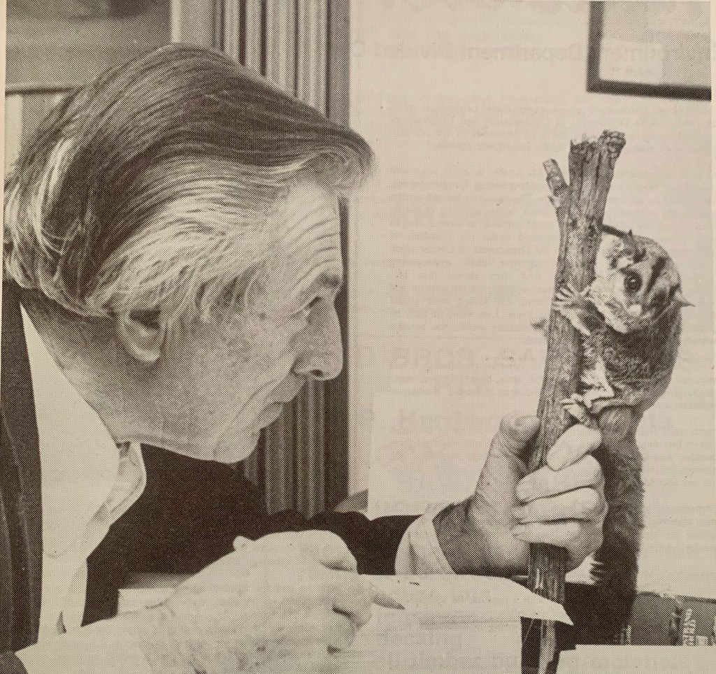
Peter Pruess was a good friend of Des Hackett who is often credited with the first successful captive breeding of Leadbeater’s Possum at his wildlife refuge in his suburban backyard at Blackburn during the early 1960s.
The story goes that Des collected possums by progressively cutting down old-growth mountain ash trees with a chainsaw around Noojee and Powelltown until he had gathered enough of the small arboreal mammals for his captive breeding program. I’m not sure if the Fisheries and Wildlife Department, or the Forests Commission, were aware of his activities at the time, but it’s hard to imagine they would have approved.
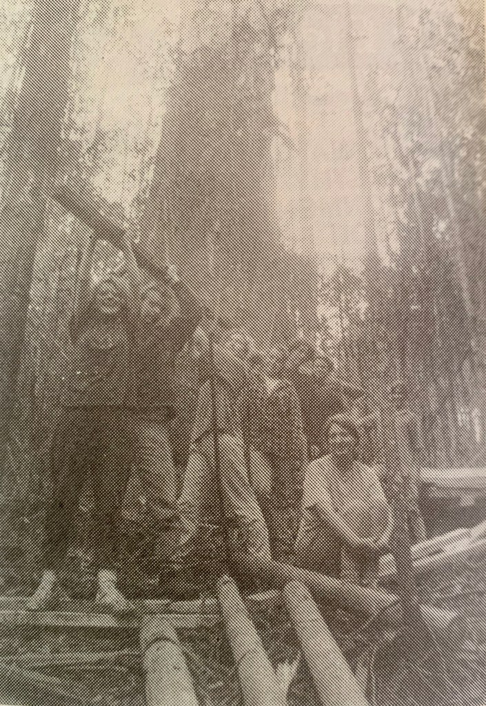
One of the large trees that Des often surveyed was on Pioneer Creek Road, east of Powelltown. The tree was probably 300-400 years old.
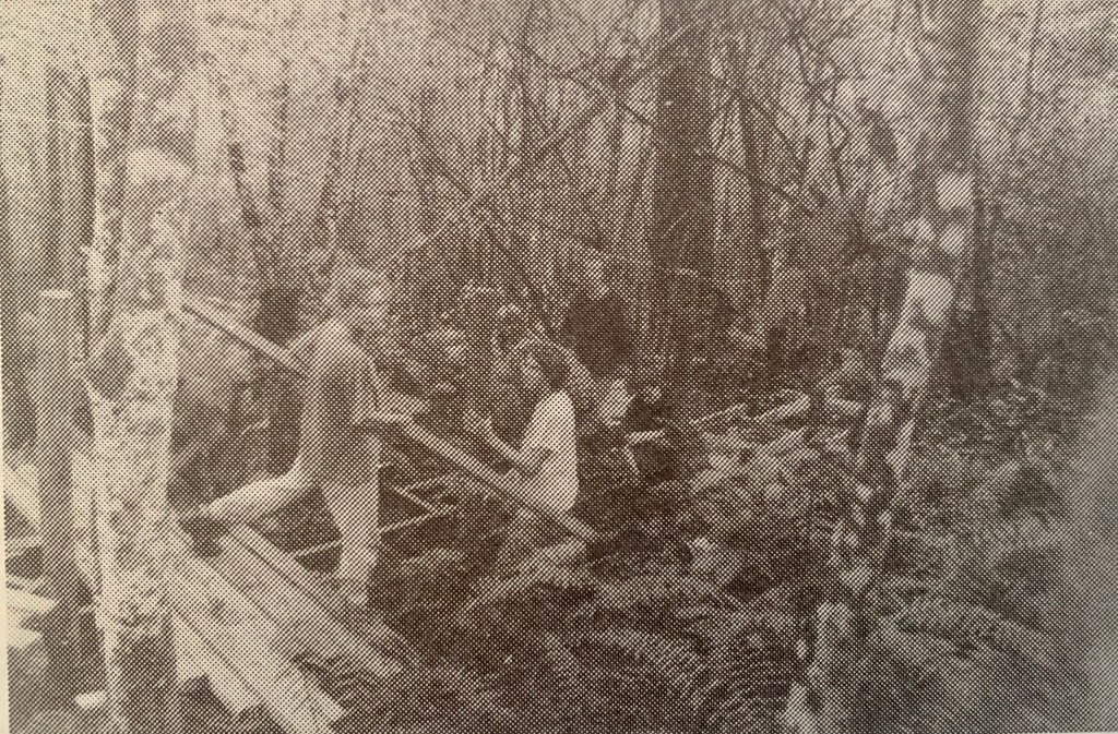
During winter, between May and August 1991, Peter Preuss, together with volunteers from the Australian Wildlife Protection Council, the Australian Conservation Foundation (ACF), the Wilderness Society, the Environmental Youth Alliance and the Upper Yarra Conservation Society, constructed a timber boardwalk and viewing platform at what became known as the Hackett Tree. The timber for the boardwalk was supplied by local sawmiller Ron Reid.
The Department was going through another restructure and downsizing process at the time, and the works on the boardwalk were largely unbeknown to senior management staff in the Regional office.
I later learned that the Operations Area Supervisor at Powelltown had been verbally advised, but he took a redundancy package and left the Department not long after. Furthermore, I saw Peter regularly at advisory committee meetings and I don’t recall him ever saying anything to me about the new boardwalk until it was nearly completed.
There was certainly never any formal or written proposal to the Region. By default, the Department as the manager of the State forests inherited responsibility for the long-term public liability risks if anyone hurt themselves.
Then in late November 1991, the boardwalk was unveiled with great fanfare by Channel Nine’s weatherman and ACF Councillor, Rob Gell. Groups of conservationists, some timber workers and school kids attended. An environmental theatre group, Vox Bandicoot, closed the proceedings with a song especially written for the event called “Don’t Hackett the Trees”.
I also don’t believe that any senior management staff from the Department were invited or attended the event. I recall that the Regional Manager, Peter Sheehan, was furious when he became aware that the boardwalk had been constructed and opened on State forest without his knowledge, or any formal written approval.
Meanwhile, tensions over the future of State forests and timber harvesting were running high and it wasn’t long until there was a reaction.
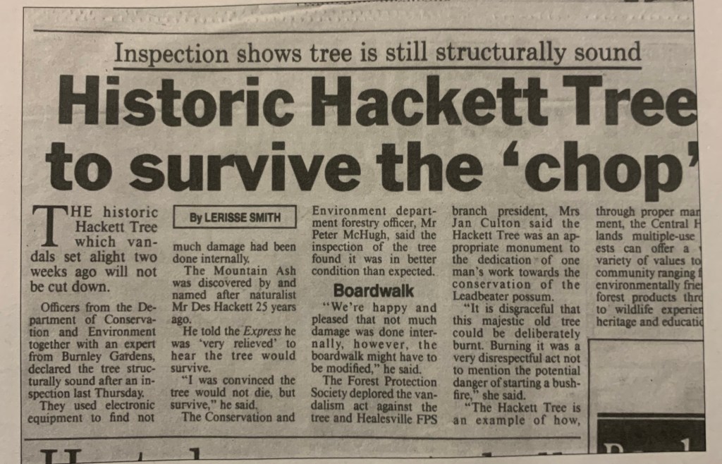
Late on Friday evening, 17 January 1992, someone took matters into their own hands and, with the aid of some diesel fuel, set fire to the base of the Hackett Tree. It was the middle of the fire season but luckily the weather conditions were mild at the time and the small fire was quickly extinguished by local forestry crews and the CFA from Powelltown.
Fortunately, the damage to the tree was minimal. Some people and the media wrongly assumed that the large fire scar on the side of the Hackett Tree was a direct result of the vandalism that night, but it was an older and pre-existing fire scar, possibly a result of the earlier 1939 Black Friday or 1983 Ash Wednesday bushfires.
Not surprisingly, Peter Pruess was seething at the wilful damage, and without any discussion or warning he invited the media to the Hackett Tree on Monday 20 January 1992. I was contacted late on Sunday evening and dropped in the deep end.
Melbourne TV channels including ABC, 9, 7, 10 and SBS converged on the tree. Journalists from The Age, the Herald-Sun and local newspapers also came expecting a clash or a dramatic headline. Local harvesting contractor, Gary Moran, came to represent the timber industry.
Allegations and rumours swirled that someone from the timber industry had lit the fire as a reprisal and, while a very likely cause, there was absolutely no evidence. The local community grapevine was oddly silent. Sergeant Bob Walker from the Warburton Police had been immediately advised and fire investigators from the arson squad later visited the site, but without any firm conclusions.
There were many difficult media interviews that Monday afternoon as I tried to diffuse the issue. I offered to seek professional advice from arborists before making any long-term decisions about the future of the tree.
Arborists from the Royal Melbourne Botanical Gardens as well as the Burnley Horticultural School subsequently visited the Hackett Tree on Thursday 30 January. They included Dr Greg Moore, Kevin Blaze and Steve Fitzgerald.
There had been suggestions and unfounded fears, amplified by the media, of the tree’s imminent collapse because it had been weakened by the fire. The arborists climbed the tree and took core wood samples which confirmed, what all the local foresters already believed, that the tree was healthy for its age and would survive. It certainly didn’t need to be felled because it was unsafe. But they did say it was unwise to encourage people to sit under the tree.
The Melbourne media were invited back to meet the arborists, but the story had gone cold, so only the junior cadet from the local newspaper turned-up.
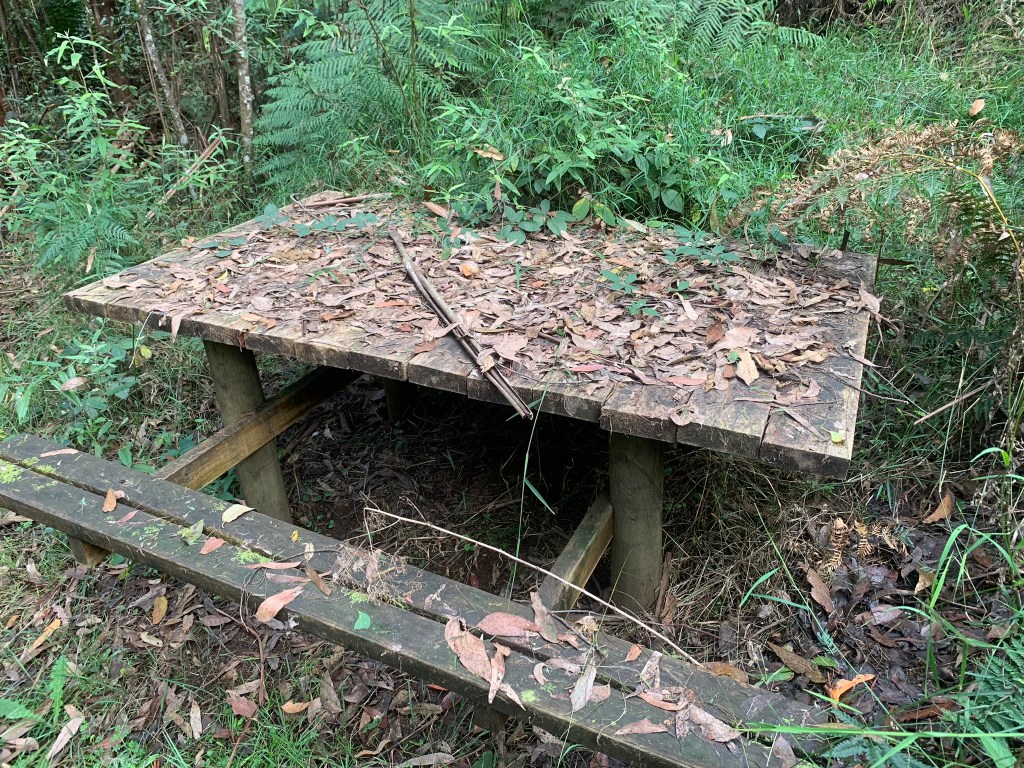
As the newly appointed Senior Forester for the Yarra Valley, the whole sorry saga put me in a difficult dilemma. Firstly, the slippery boardwalk structure had not been officially approved. But more importantly, it was poorly constructed and presented a significant long-term public safety risk. For example, the timber walking surfaces weren’t flat and sloped downhill making it hard enough to stand on even when it was dry. The steps were uneven, and the tread and lift dimensions didn’t meet any design or safety standards. Some sharp nails and bolts even protruded from the decking and handrails.
But to repair or remove the boardwalk would have been too inflammatory under the circumstances. So, it was decided to adopt a benign stance and allow time and nature to take its course.
Furthermore, it was decided not to maintain the boardwalk or promote the Hackett Tree to the general public with either directional or interpretive signs, nor highlight its location on forest maps and tourist brochures. People could continue to visit, but at their own risk.
I advised Peter Preuss of the Department’s position but not surprisingly he viewed things differently and was not happy with the decision.
But it was also decided to protect the tree from logging or disturbance with a large 200 m buffer. Later, a formal Special Protection Zone (SPZ) was set aside in the Forest Management Plan.
Unlike the previous experience with Werner Marschalek and the Ada Tree, if there had been some consultation in the design and materials used for the boardwalk at the Hackett Tree, it undoubtedly would have been supported and approved.
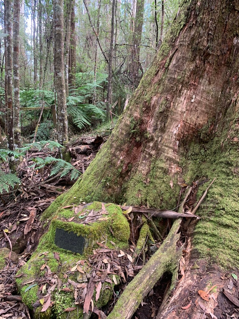
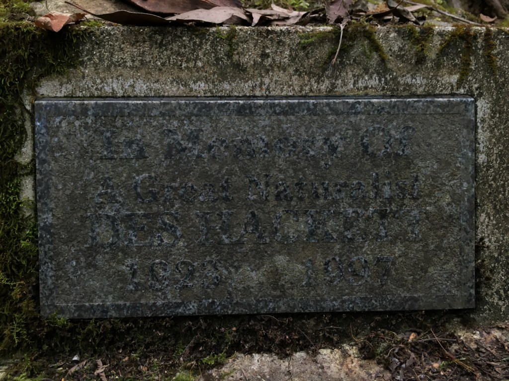
Des Hackett, the man who owes the tree its name, died later in 1997. A small memorial was concreted at the base of the tree, but it has become difficult to read.
The wooden boardwalk continued to slowly rot away and in about 2003 some of it was removed. The shelter and other remnants remain.
Some schools and conservation groups continue to visit the Hackett Tree, often with Peter as their guide. There is also a geocache at the tree which attracts some visitors.
A recent proposal to rebuild the boardwalk has been examined, but once agian arborists advised that the Hackett Tree was still too dangerous to encourage people to visit, or certainly sit under it.
The Hackett Tree continues to survive but is slowly senescing and its crown is showing its age. I’m not sure if there have been any recent surveys to determine if Leadbeater’s possum still live in it.
The large fire scar on the uphill side probably originates from either the Ash Wednesday bushfires in 1983 or the earlier 1939 Black Friday blaze. Photo: Tom Fairman 2016.Photo: Peter McHugh 2024Photo: Peter McHugh 2024Photo: Peter McHugh 2024From “Born to be wild” by Peter Preuss (2013)From “Born to be wild” by Peter Preuss (2013)From “Born to be wild” by Peter Preuss (2013)The cover of the booklet. Photo: Peter Pruess 1991Des Hackett at his home in Blackburn. Photo: Peter Pruess 1991From “Born to be wild” by Peter Preuss (2013)Photo: Peter McHugh 2024Photo: Peter McHugh 2024With the forest advisory committee. Photo: Peter McHugh 1991.
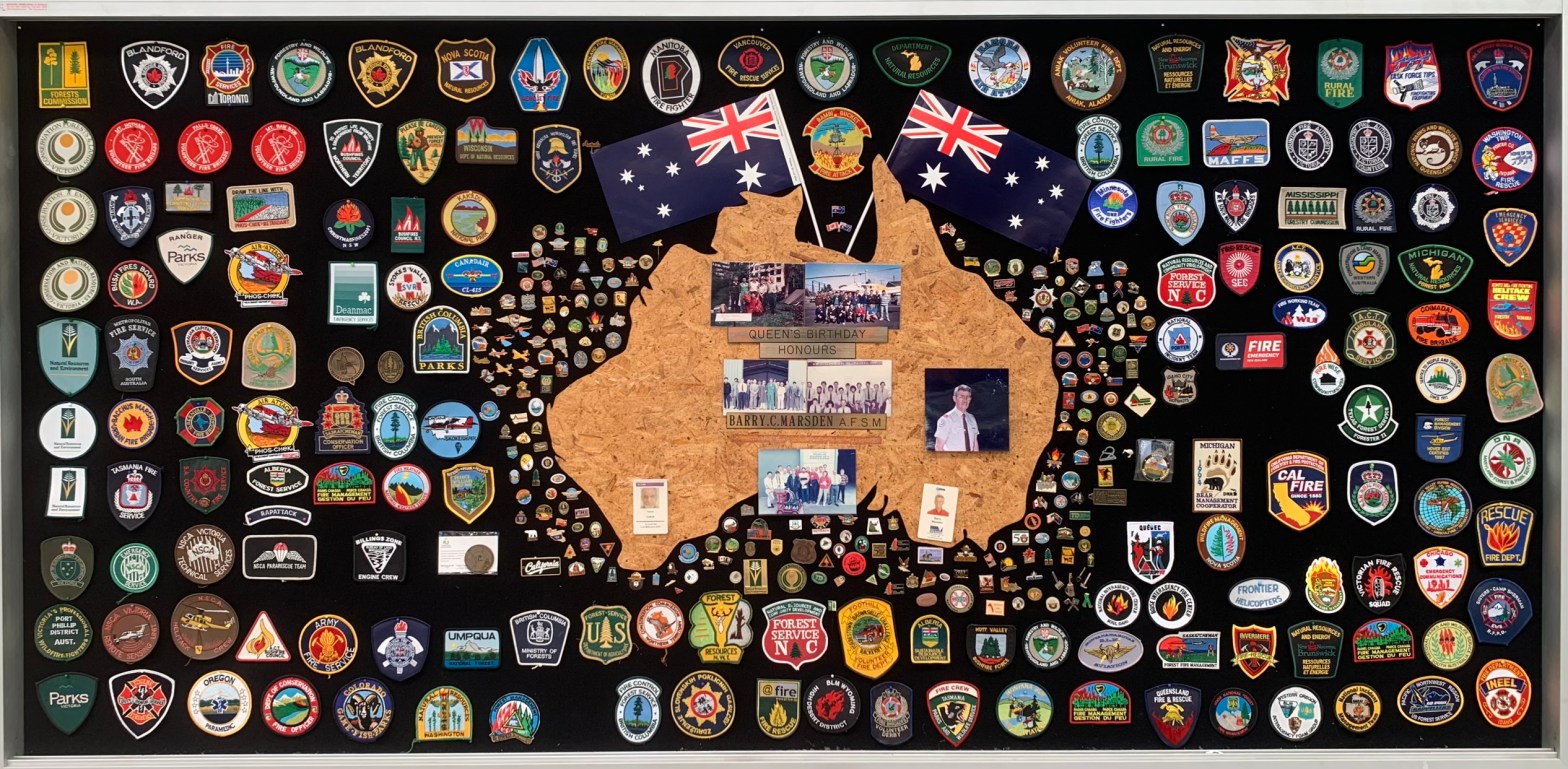
The Forests Commission and its successors continuously encouraged bushfire research and innovation.
In 1946 a large parcel of industrial land was purchased at North Altona as a fire equipment cache and workshop.
The Altona workshop became a hotbed of new technological thingumajigs… a marvellous blend of Aladdin’s Cave of Wonders coupled with Wallace and Gromit’s madcap contraptions… an exhilarating place where lots of gizmos were invented and tested… mostly with astounding results… but nearly always with some head-scratching frustrations… and thankfully not too much explosive mayhem.
In fact, a lot of Australia’s pioneering equipment development was led by staff from Altona, often in collaboration with other State forestry and fire authorities. The CSIRO also contributed significantly.
The US Forest Service, the US Bureau of Land Management and US State agencies such as the California Department of Forestry and Fire (CalFire) as well as the Canadian Forest Service faced similar challenges and proved strong and willing partners in sharing knowledge, ideas, equipment and expertise over many decades.
A small museum of some of these amazing inventions and other eclectic stuff collected by fire equipment wizard Barry Marsden is housed at Altona. It can be visited by appointment.
This collection of badges is testament to the relationships that were forged across the globe with staff from the Altona workshop.