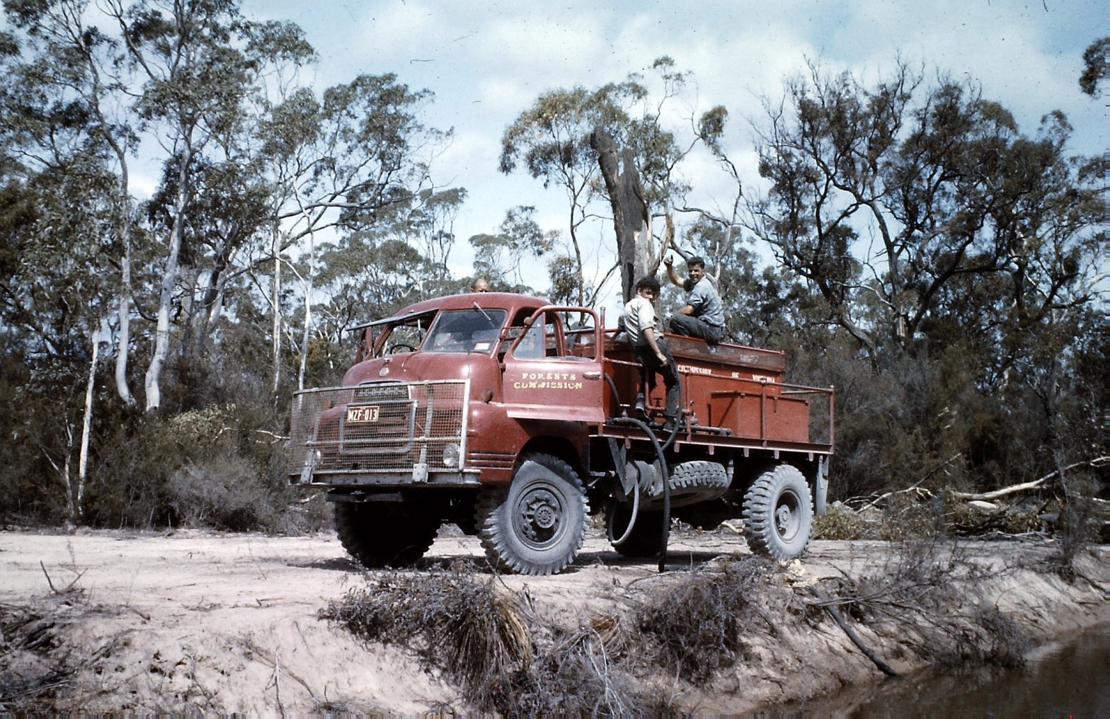
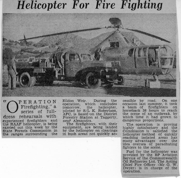
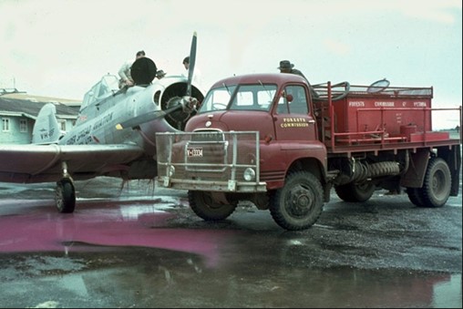
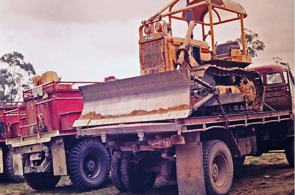
The Forests Commission imported the first two Bedford RLHS cab/chassis trucks into Australia from England in January 1959.
John Phillips and Syd Bloxidge were flown to Sydney by GV Clarke Motors to drive the vehicles back to Melbourne.
They were assembled as tip trucks for use on the Tamboritha Road project north of Heyfield.
Based on their success, additional trucks were purchased and fabricated into FCV fire tankers.
They were designed using the configuration of the earlier ex-military Blitz tankers, with a rectangular tray-mounted water tank and a manually operated hose reel attached to the tank lid. Side grab rails were installed along each side of the tray.
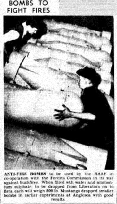
The water tank had three connecting compartments providing a total capacity of 600 gallons.
The Howard pump engine equipped with a rope start could be temperamental and difficult to start and was later replaced with an electric start 7 HP Wisconsin Gaam 30B pump.
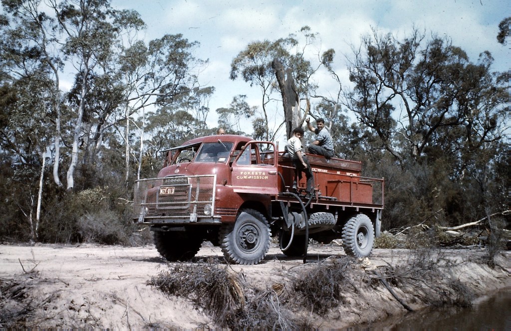
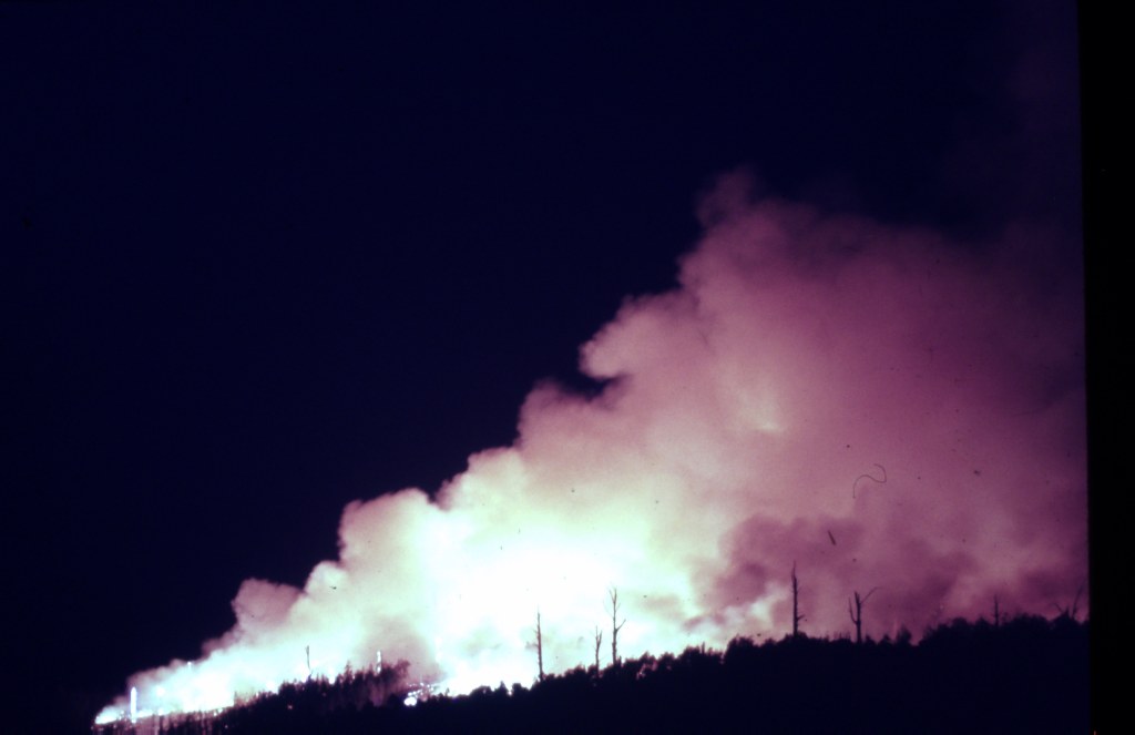
This example of a Bedford bullnose tanker from Casterton is refilling at the Stawell fire #16 in March 1964. The truck was notable for having a forward-opening windscreen. Les Twigg was driving but the other two people are unknown.
Photo: Gregor Wallace Collection.
Bedford bullnose tanker from Casterton is refilling at the Stawell fire #16 in March 1964. Photo: Gregor Wallace
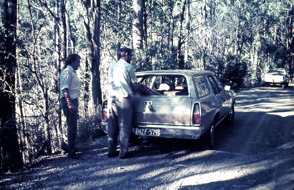
The two new Bedfords on their way from Sydney – January 1959. Source: Rocky Marsden
During the late 1960s, recreation and conservation on State forest was receiving greater community focus. A key moment for the Forests Commission came in August 1970, then under the new chairmanship of Dr Frank Moulds, with the creation of the Forest Environment Branch.
This initiative was a first for any Australian Forest Service, and its brief soon widened. By 1971, it became the Forest Environment and Recreation (FEAR) Branch, firstly under the stewardship of Athol Hodgson and later Stuart Calder.
In January 1971, Tom Morrison became one of the founding members of FEAR which was based at Treasury Place in Melbourne.
They say, “apples don’t fall far from the tree” and there seems little doubt that Tom was strongly influenced by his father, Philip Crosbie Morrison, the legendary naturalist, educator, journalist, broadcaster and conservationist.
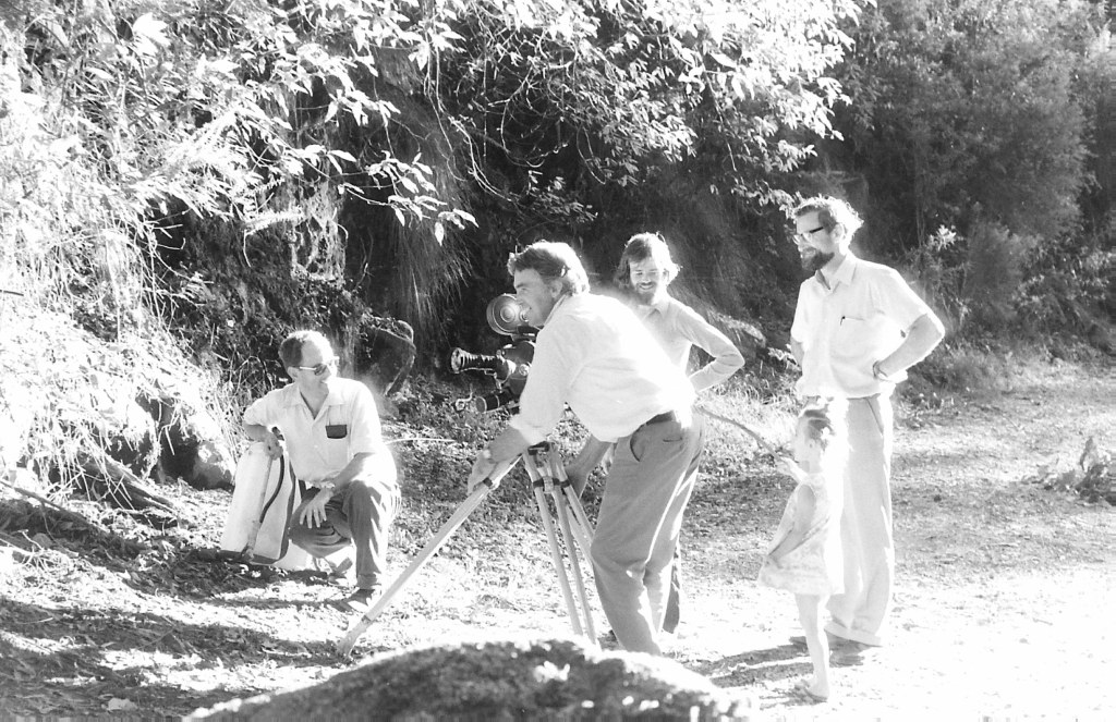
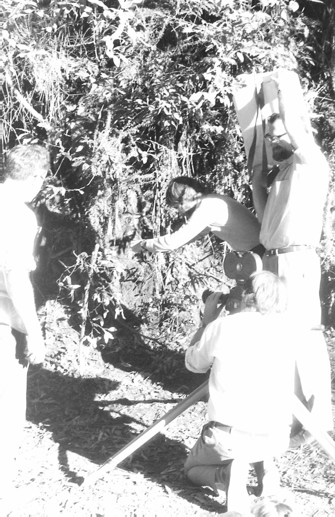
In 1973 a colour film entitled “The Living Forest” was released. The Forests Commission sponsored the film and Tom provided technical direction with support from other FEAR Branch staff including Kester Baines, Paul Sholly and Kris Lysenko.
The film was produced by the talented Ken Widdowson from Educational Media Australia, while David Morgan from the Melbourne College of Education provided advice, and professional cinemaphotographer, David Cork, was engaged to make the short educational film.
The 22-minute film portrays, beautifully for its time, Victoria’s forests and woodlands including its flora, fauna, water, soils, recreation and tourism use, fire management and economic values, including the timber industry.
The film also briefly examines the Forests Commission’s “multiple use” philosophy and explored the importance of balancing the environmental and economic demands that community’s make on State forests.
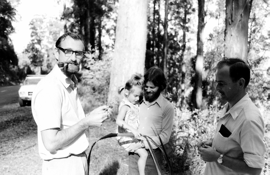
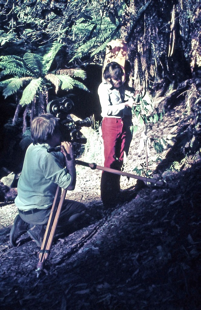
Some of the footage for The Living Forest was taken in April 1973 at East Warburton where forester, Gregor Wallace, was posted. The artful film making was near Mt Donna Buang on a roadside in the head of Myrtle Creek, looking down to Yarra Junction and Millgrove. It turned into a family affair with Gregor’s wife Norma, their daughter Kerryn, and even their personal Holden car appearing in the film.
At one point, the script required rain dripping from leaves, but it was a sunny and warm day, so Gregor and Kester used a knapsack full of water as a prop to create the desired effect. A reminder maybe not to believe everything you see in a film, not even in a government documentary.
Gregor also reminisces –
On another day the FEAR Branch needed a sequence with a family arriving in their car at a survey point in the forest and being greeted by a forester; no speaking parts required with the narrator of the film doing all of the persuasion stuff. A convenient spot was found on the Woods Point Road at Starvation Creek. I was the smart young forester and was filmed welcoming Tom Morrison, driving my car, with my wife in the passenger front seat, and my daughter looking out of a rear window. Well did I ask just what was going on !!!!!
These few seconds in the film, near the end, took half a day to make and provided a good bit of amusement. I think that this was Tom’s only appearance in the film.
A closing piece in the film is of a group, well a small crowd really, of young folk at O’Brien’s Crossing on the Lerderderg River, downstream from Blackwood. I understand that Tom organised a picnic day and a small bus load of Head Office staff and their families as the film “extras”.
Mike Wade is the young forester with the stereoscope and aerial photographs and chinagraph pencil on the Land Rover bonnet. He is with Les Lasham picking the line for a new walking track.
Max Roker is the man with the yellow tree marking paint and taking a DHBOB or girth measurement.
Norma gets a gig with binoculars and a distant view.
I think that a lot of the bird and animal shots were done at Healesville Sanctuary.
This film was the last in the noble tradition of public education that gave us ‘Calling VL3AA’, ‘Harvest of the Hills’, and all of those others that were taken on the road and shown in country halls and schools.
The film was innovative for its time and proved popular with a very strong demand for showings from schools and other groups.
These photos were taken in April and May 1973 and are from the amazing archives of Gregor Wallace.
The Living Forest – 1973.
David Cork and Tom Morrison.
Gregor Wallace, David Cork, Kester Baines, Tom Morrison, and Kerryn Wallace.
Water dripping off a leaf. Tom holding the knapsack with Kester Baines releasing slow drops of water.
Tom Morrison (with pipe), Kerryn Wallace, Kester Baines and Gregor Wallace.
David Cork and Kester Baines with the knapsack on his shoulder and dripping water.
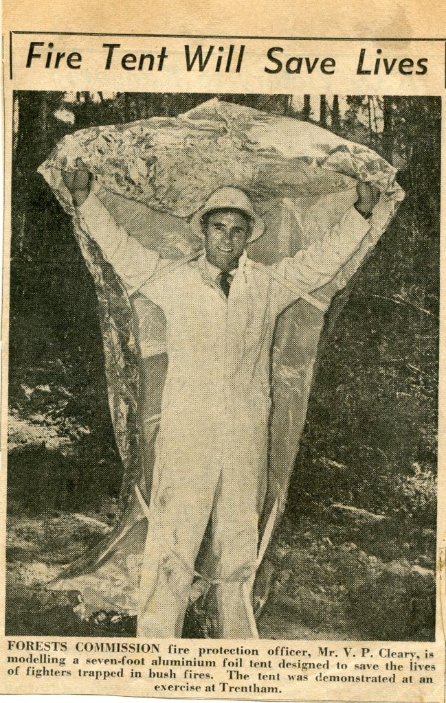
The first personal bushfire survival shelter in Australia was developed by the CSIRO in 1958.
The main issues to overcome were protection from radiant heat, avoiding smoke and any toxic fumes from the tent materials, and being able to breath cool air.
The bell-shaped tent was made of laminated aluminium foil and was tested in January 1959 on the flank of a 100,000-acre fire in East Gippsland, but the formaldehyde adhesive produced toxic fumes.
However, the results were promising enough to continue with testing a second A-frame design in 1959 using a resin rubber adhesive.
Around the same time, the North Americans also began developing a fire shelter and the two countries collaborated closely.
The Forests Commission continued to experiment with shelters as late as 1962 at Trentham but decided not to adopt them.
The current American shelters are designed to be deployed within 30 seconds or less by removing from them from their carry bag and shaking them to expand the tent outward. The firefighter then climbs inside and holds it down with their arms, knees and feet to keep the flames and hot air out
The shelters are intended as a last resort of defence and are sometimes referred to as “shake and bakes”.
Personal fire shelters are mandatory equipment in America and while many lives have been saved there have also been many fatalities using the tents.
In 2013, 19 firefighters from the Granite Mountain Hotshots died in the Yarnell Hill Fire in Arizona after deploying shelters when flames overtook them in a steep canyon.
The idea occasional resurfaces in Australia but the use of bushfire shelters for personal protection has not been adopted. Agencies instead preferring other on-ground tactics to minimise firefighters’ exposure to danger.
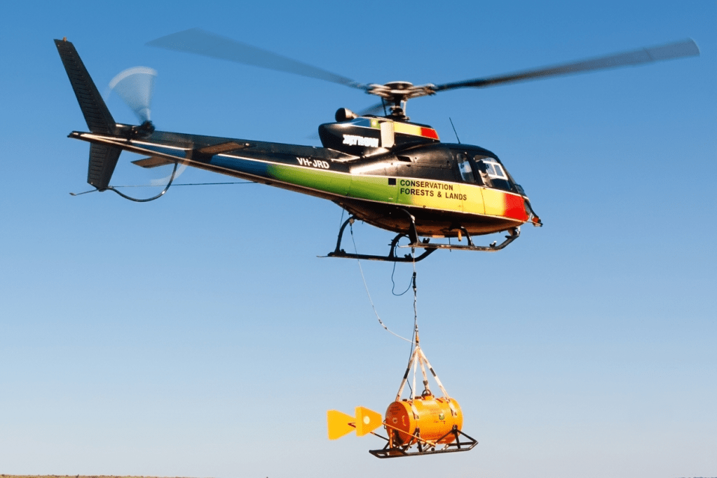
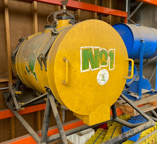
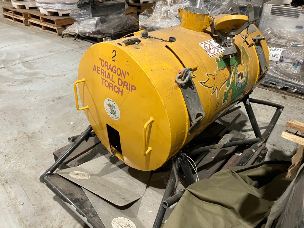
The idea of an Aerial Drip Torch (ADT) was first conceived in Canada in the 1970s by the legendary forester, firefighter and inventor, John Muraro.
The drip torch was further developed in 1982 by the New Zealand Forest Service and became known as the Ashley Aphid Helitorch.
In February 1987, Forestry Tasmania acquired one of the NZ machines and modified it to meet Australian aviation safety standards. Known as the “Red Dragon” it consisted of a large 135-litre tank containing jellied petrol, a displacement pump, propane ignition system, burner nozzle and fire extinguisher system.
A commercial gelling agent such as Flash-21 was used to thicken unleaded petrol to form a sticky blob-like consistency that dripped and ignited safely without separating. The gelling agent is not made with the same ingredients as napalm as is commonly claimed.
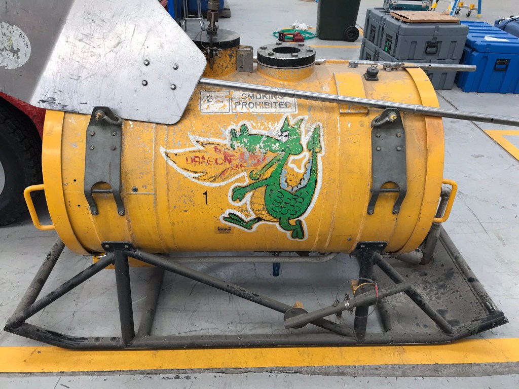
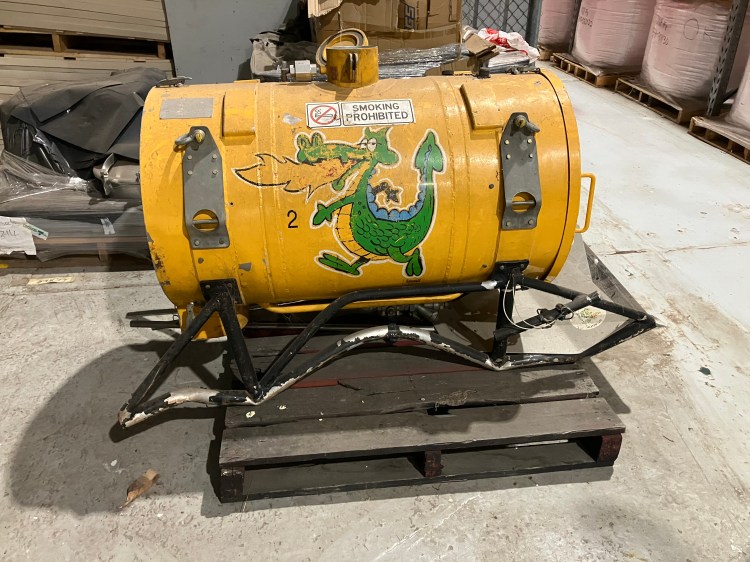
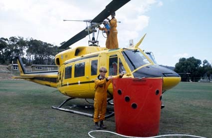
Building on the Tasmanian experience, two Yellow Dragons (ADT-1 & ADT-2) were designed and fabricated at the North Altona workshops by Rocky Marsden in the early 1990s. They were developed in conjunction with the Department of Conservation and Land Management (CALM) in Western Australia.
In Autumn 1991, the Yellow Dragon was first trialled on regeneration slash burns at Erica and Swifts Creek. It had a dry weight of 160 kg and a capacity of 130 litres which provided about an hour of operations. It was slung about 7 m beneath a light helicopter.
The incendiary machines proved successful, so a third Dragon called Lucifer or “Lucy” was introduced in 1998. It had a larger capacity 200 litre plastic tank but was much lighter with a dry weight of only 68 kg.
The design and safety features of the Aerial Drip Torches continued to evolve and their use for burning operations has now become routine. DEECA/FFMVic currently operates seven machines (6 x 200L and 1 x 400L) – but none have names given to them nowadays.
Over time, all three of the original Dragons were thought to have gone missing, but ADT-1 is now safely in a storage rack at North Altona, while ADT-2 was found at Avalon Airport – a bit worse for wear – and will return to its rightful place in the North Altona museum. The fate of Lucy remains a mystery, but it is believed she was disposed of many years ago.
The Forests Commission and its successors have continuously encouraged bushfire research and innovation. In 1946 a large parcel of industrial land was purchased at North Altona as a fire equipment cache and workshop.
Over the decades, much of Australia’s pioneering fire equipment development was led by some very clever and dedicated inventors at North Altona, often in collaboration with other state and international forestry and bushfire authorities.
The Altona workshop became a hotbed of new technological thingumajigs… a marvellous blend of Aladdin’s Cave of Wonders coupled with Wallace and Gromit’s madcap contraptions… an exhilarating place where lots of gizmos were invented and tested… mostly with astounding results… but nearly always with some head-scratching frustrations… and thankfully not too much explosive mayhem.
The Dragons are just one small example, but the future of in-house fire equipment development at North Altona is currently under a cloud.
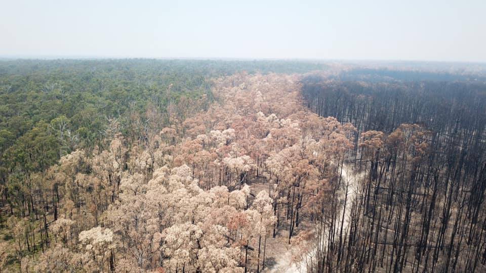
At many places across the State forests of the Central Highlands there were large and dense stands of silver wattle (Acacia dealbata) which had replaced the original mountain ash (E. regnans) forests because of repeated bushfires in 1926, 1932 and 1939.
By the early 1970s, silvicultural knowledge had grown after the pioneering work by foresters like Jack Gillespie, and the methods of regeneration by clearing of overstorey, burning of slash and seeding or planting were well known, but the problem of reforesting sites in dense growth of wattle remained.
Firstly, a fixed-wing aircraft flying from Sumner Spur was used to spray chemical herbicide mixed with diesel to kill the wattle.
Two FCV bulldozers then dragged heavy chains to bring down the dead stems, which was followed by a spectacular slash burn to prepare the site.
But burning the wattle slash hot enough to create a receptive seed bed was a problem.
Unlike Fuel Reduction Burning (FRB), which required a slow moving and low intensity fire, slash burning required a very hot fire, usually in late summer to early autumn when there was still a risk of bushfires.
One solution to reduce the risk was to burn at night when the temperature was falling, the relative humidity was rising, and the wind had dropped off.
The area to be burnt was prepared by surrounding it with a solid earth break and a road to provide access for vehicles and tankers.
It required great skill, as well as a bit of courage, to light these burns and choose the moment of ignition. The wattle slash fuels needed to be very dry (<10% moisture content) but for the adjoining areas to be wetter (preferably >20%) to create a fuel moisture differential. A bit of light rain in the days before the burn was a big help.
High intensity slash burns are risky, and the final decision was made late on the day by the District Forester.
The burn was lit on dusk by crews with drip torches, beginning in the centre to develop a strong convection column to draw the hot fire inwards. More fire was then added around the perimeter until the whole thing was alight.
As the fire died down crews could then relax, and at around midnight there was often a convivial cook-up around a small campfire. A skeleton crew remained until dawn.
In a few days an aircraft would spread coated eucalypt seed on the receptive seedbed to regenerate a new forest.
Burning at night was once common but seems rare these days.
These amazing photos are from the Gregor Wallace collection and were taken at a night slash burn on Britannia Range near Powelltown on 4 March 1970.
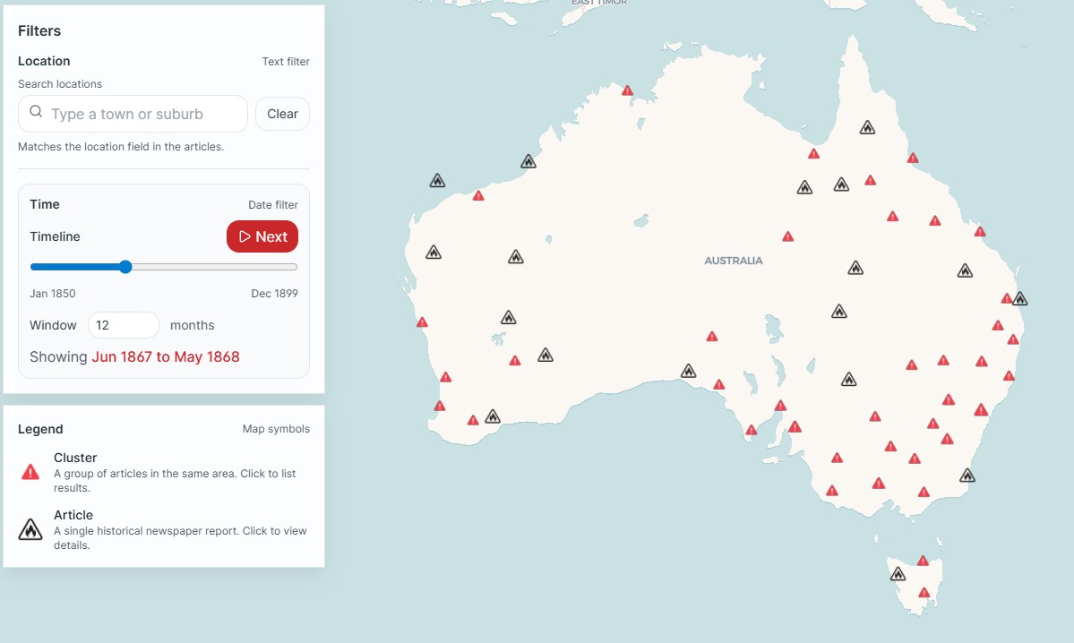
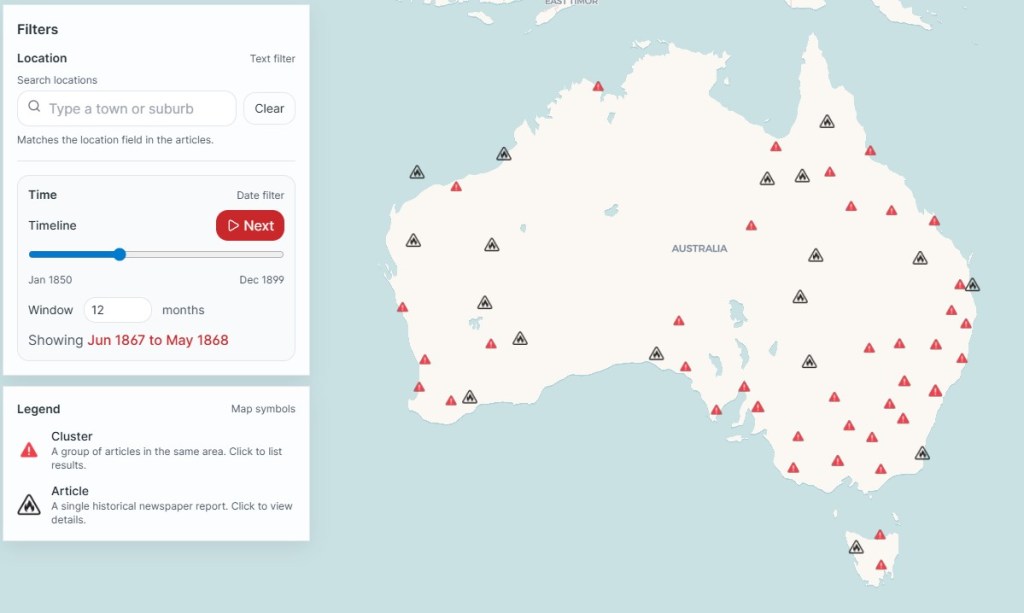
Librarian, Dr Fiannuala Morgan, recently used historical newspaper records held in Trove to reconstruct and map bushfire occurrence from 1850 to 1900.
The major bushfires in colonial Victoria in 1851 and 1898 are well known but there is not much information for the periods in between.
Trove holds millions of digitised pages from old newspapers and magazines, but reporting and sorting is messy.
A key word search of Trove found about 120,000 articles about bushfires between 1850 and 1900.
By applying Named Entity Recognition (NER) to the results, it was often possible to map the location of the bushfire based on its proximity to a place name.
The research highlights how bushfires shaped Victoria’s 19th century, and how they changed over time.
Following the gold rush of the 1850s, the Victorian government opened up large areas of crown land for selection. Much of the land was heavily forested and difficult to access, especially in Gippsland. The freehold land was then cleared and converted into agricultural or pastoral properties mainly with backbreaking toil and fire.
There are still gaps in the historical data and many bushfires went unreported because they were common and not newsworthy. Bushfires on remote State forests were also probably not reported.
This amazing interactive map shows where and how often bushfires occurred across the colonies over fifty years, but details on fire severity or size require consulting the original newspaper stories.
It’s been said many times before, that internationally, south-eastern Australia is considered one of the three most fire-prone landscapes on Earth. The other places being southern California and the southern Mediterranean.
Bushfires have undoubtedly always been a feature of Australian summers. In an average year, between 600 and 1000 bushfires occur in Victoria’s National Parks and State forests, which burn about 110,000 hectares, with a large proportion being in the vast forests of Gippsland and north-eastern Victoria.
Most of the bushfires on State forests and National Parks in Gippsland were small and often started by lightning.
Early detection combined with rapid and determined first attack to keep bushfires small. In most cases, first attack is successful, but the story rarely makes the media.
I was based in Gippsland as the Senior Forester from 1994, and for me, the tempo, size and severity of bushfires seemed to intensify from the late 1990s following the Caledonia fire.
In combination with its many bushfires, floods and storm events, Gippsland became jokingly known as “Disaster Disneyland”.
It also seemed that the fire seasons started earlier and lasted longer, with underlying drought and prolonged dryness of the bush and lower relative humidity, particularly at night, being a key factor.
Over time, the terms “mega-fire” and “campaign-fire” became part of the common language of foresters and firefighters.
There were all sorts of theories and allegations advanced to explain the massive and long running campaign bushfires that Victoria experienced beginning from the late 1990s. They ranged from –
budget and staff cutbacks.
loss of experienced firefighting staff in the field.
procrastination, risk aversion and fear of litigation.
a subtle shift from prevention to suppression.
lack of fuel reduction burning.
drought & climate change.
political interference.
Some of this was partly true, but some was just rubbish, and the Department and the staff came in for all sorts of harsh and unreasonable criticism from politicians, the media, the community and the many armchair experts. Attacks on social media became relentless and toxic…
The answers are never simple and one dimensional as many would hope or claim. Climate Change being the most convenient and simplistic explanation.
Recurring bushfires.
Over the last century, Gippsland experienced major bushfires on Black Thursday – 1926, Black Friday – 1939 and Yallourn – February 1944. The latter two, resulting in groundbreaking Royal Commissions by Judge Stretton.
More recently, over the last 60 years, major fires occurred in March 1965, October – 1980, Ash Wednesday – 1983, Caledonia River – 1998, alpine fires – 2002-03, Dutson bombing range – 2004, more alpine fires 2005-06 & 2006-07, Black Saturday – 2009, Aberfeldy/Seaton – 2013, Jack River – 2014, Rosedale – 2019, Black Summer 2019-20, Loch Sport – 2023 and Dargo – 2026. And there were many others too…
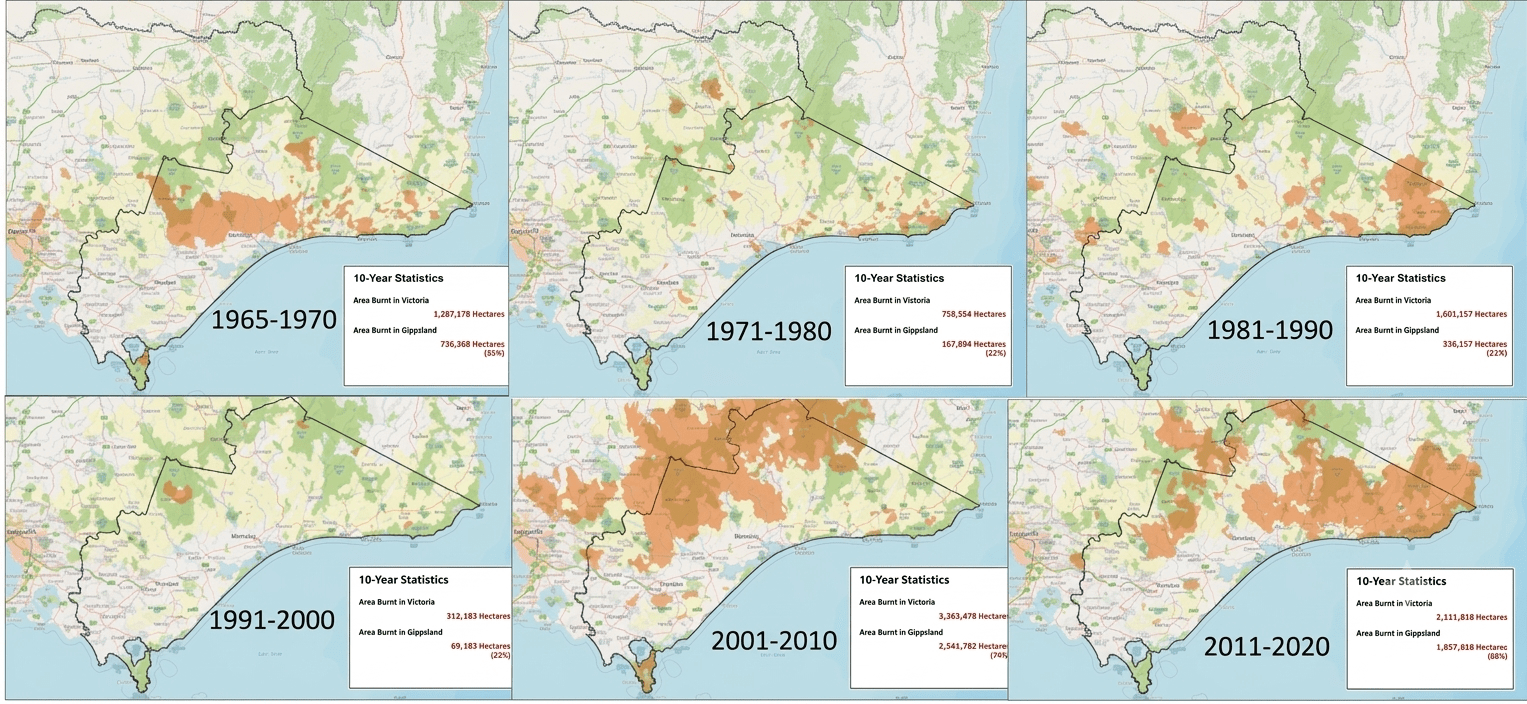
Some parts of the bush in eastern Victoria were burnt severely and repeatedly which had major environmental consequences, particularly for susceptible ecosystems like snow gum woodlands, rainforests, alpine ash and mountain ash forests. About 276,000 ha was burnt multiple times since 2000, and forest stability was undoubtedly compromised.
Known as the Tolerable Fire Interval (TFI), some species and forest types require a relatively short inter fire period, or frequent burning, whereas others need a very long time to allow for plant and seed maturity, and for habitat tree redevelopment.
Another significant consequence of the frequent bushfires was that the complex mosaic of age structures and forest fuels was effectively wiped clean, leaving large areas with just a single age class.
Reintroducing fire back into the broader landscape to achieve some sort of fuel complexity and balance is a major long-term challenge.
Grass fires in the bush?
Major bushfires can totally remove tree crowns, and many trees may even die.
As the bush slowly begins to recover the understory vegetation is often temporarily replaced by grasses, particularly giant mountain grass (Dryopoa dives), until the tree canopy reestablishes and closes over again.
If there is another major bushfire before canopy closure it can develop into a fast-moving grass fire rather than a slower moving bushfire.
A good example was at Seaton in 2013 which burnt intensely overnight, at breakneck speed, and faster than anyone predicted, through giant mountain grass that had sprouted from an earlier Walhalla bushfire in 2007.
Risk Aversion.
There is no doubt that serious injuries or deaths of firefighters or losses in communities shakes all firefighters to their very core.
The risks are very real. There have been several deaths of forest firefighters, mostly from falling trees and branches, over the last few decades.
Understandably, nobody wants to cause or to feel responsible for these losses. PTSD is common among forest firefighters but is largely silent, undiagnosed and untreated.
The unfair attacks by lawyers, the media, the community and armchair experts iduring the 2009 Black Saturday Bushfires Royal Commission against senior CFA and Departmental staff had major long-term ramifications.
Everything always seems inevitable in hindsight…
Risk assessment, risk avoidance and procrastination then became a dominant feature.
AIIMS incident management, which was originally introduced by the Forests Commission after Ash Wednesday in 1983, was designed to be light and nimble, but became centralised, overblown and cumbersome.
There is a VERY big difference between taking risks and being reckless…
Part of the response to risk avoidance after Black Saturday was to add more layers of management (fire ground, incident, regional and State control), more processes, checkboxes, data collection, teleconferences, micromanaging, analysis paralysis and time-wasting procedures. But there is often no time to waste with a fast-moving bushfire and those on the ground are often best placed to decide…
Be decisive…. right or wrong…. make a decision…. The road of life is paved with flat squirrels that couldn’t make a decision…
Senior bushfire staff in Australia also watched in horror as our American counterparts were being regularly taken to court and sued. Some American fire managers even resorted to taking out professional indemnity insurance. For example, the families of the 19 firefighters killed at Yarnell Hill Fire in Arizona in 2013 filed a wrongful death lawsuit against the state and the incident command for negligence. The courts ultimately ruled against the claimants. But the damage was done.
And despite assurances at home in Australia – that if you did your job properly and followed the rules – it sent shockwaves through all senior ICC firefighters.
Claims for industrial manslaughter, stress related illness and community class actions seemed to climb in number.
Some (me included) refused to accept senior ICC roles like Level 3 Incident Controller after being savaged in the Black Saturday and 2014 Hazelwood mine fire inquiries.
Shift from prevention to response.
As technology advanced, firefighters were always quick to embrace it… which is a good thing… (e.g. aerial reconnaissance – 1930, helicopters – 1949, fixed-wing firebombing – 1967, helicopter firebombing – 1983), all began in Victoria.
Don’t get me wrong, there are some very talented and committed young people in FFMVic, but shortages of experienced fire crews, resources and incident managers, became very apparent over time. Aircraft are useful and important but there is absolutely no substitute for “boots-on-the -ground”
These shortages resulted in a steady and subtle shift from prevention (fuel reduction burning) to more expensive suppression (helicopters and large firebombers).
In the summer of 2006-07, lightning started 66 fires between 1 and 3 December. By the 10 December, 46 fires were still uncontained but, more importantly, 24 of them had few, or no on-ground resources allocated to them at all, other than some aerial reconnaissance or firebombing from above, leaving them to burn unchecked and grow in both area and perimeter in heavy fuel.
These fires were all initially in steep inaccessible country and remote from towns and settlements. But the cumulative area of bushfire escalated exponentially.
No amount of heroic suppression effort by on-ground crews or aerial firebombers can then overcome the deadly combination of extreme weather, rugged terrain and heavy accumulation of fuels when a bushfire escalates to landscape scale.
These 2006-07 bushfires eventually joined and burnt for two months, with an overall area in excess of 1 million ha, and impacted settlements and farmland along the interface. A total of 33 houses were lost and over 1300 km of fencing destroyed.
It was a similar story during Black Summer in 2019-20 when several fires deep in the bush, and not presenting an immediate danger, were left to burn largely unchecked. But they eventually grew too big and joined up to threaten Cann River and Mallacoota.
Kevin Tolhurst & Greg McCarthy (2016) Effect of prescribed burning on wildfire severity: a landscape-scale case study from the 2003 fires in Victoria, Australian Forestry, 79:1, 1-14, http://dx.doi.org/10.1080/00049158.2015.1127197
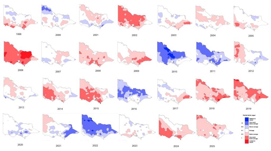
Victorian rainfall maps from 1999 to 2025 (27 years). Firstly, there is a lot of annual variably; there are more dry years than wet years; major bushfires occur in the years with low rainfall; dry years and bushfires are often followed by wet years that bring floods. Source: BOM
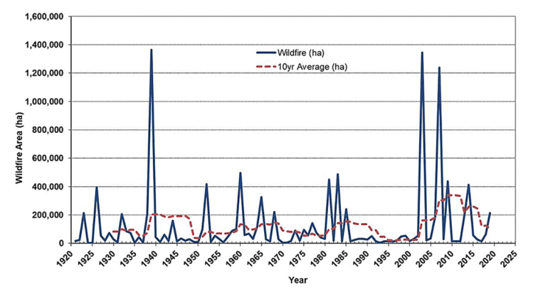
Bushfires in Victoria since 1920. The solid line is the annual total area burnt by bushfire and the dashed line is the rolling 10-year average. Source: Morgan, Tolhurst et al. https://www.tandfonline.com/doi/full/10.1080/00049158.2020.1739883Mountain grass grows quickly after bushfires and remains a thick undergrowth until the tree crowns reestablish, but presents a significant fire hazard in the meantime
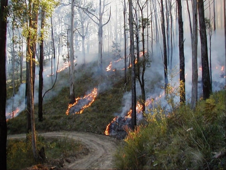
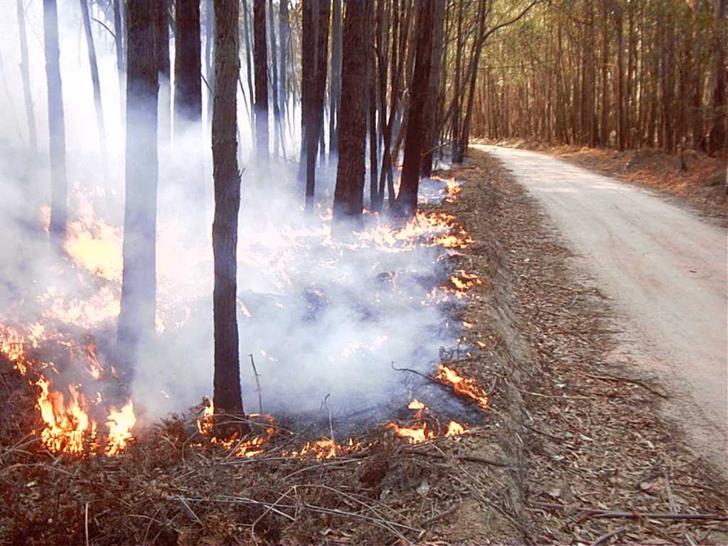
Many seasoned firefighters advocate for a return to the methods used in the 1960s and ‘70s when the Forests Commission lit small spot fires on main ridges in the back country during autumn and let them trickle down the slope and go out overnight, or in a day or two.
These small, widely spaced spot fires were lit late in the day when the temperature and wind was dropping and the RH was rising, so they would burn slowly outwards in circles and either join-up or fizzle-out late in the evening. Flame heights were deliberately kept low, which resulted in minimal tree crown scorch. The burns were patchy (~70 – 80% coverage) so the fuel was reduced but not eliminated.
Fuel reduction burns in late autumn and early winter, on the top one third of the north facing ridges, is easier to achieve and very effective at breaking up the broader forest landscape into manageable blocks.
Importantly, these burns would often extinguish themselves up against natural boundaries like rocks or creeks, boundaries like roads and tracks, or shady areas on southerly aspects.
They were planned to adjoin areas that had been fuel reduced a few years earlier to create an interlocking mosaic. A bit was burnt each year, so they became multi-aged and often left unbounded (not requiring a hard-edge burn perimeter).
Ridgetops are generally where lightning strikes during summer (See: Gippsland Zig-Zag). Reducing this fuel can keep fires small and close to the point of ignition which gives a better chance at early suppression.
If first attack fails, often the only safe strategy is to build major fallback lines in combination with backburning and patrol that can take weeks or months. This also brings additional costs of control and rehabilitation.
Ridgetop burning helps keep the fires contained in the bush rather than letting them come out of the forest into the cleared farmland.
The objectives of landscape burning are different from asset protection works which are generally closer to towns and settlements. In conjunction with slashing and mulching, the frequency and intensity of asset protection works are more significant.
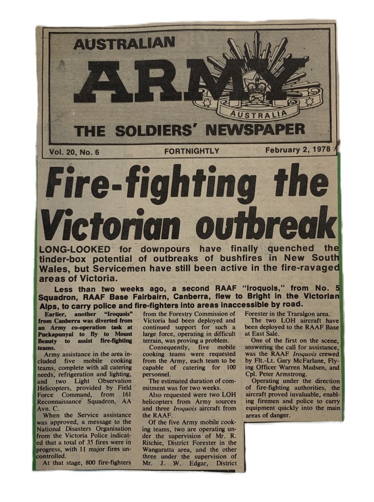
Alpine fires of January 1978.
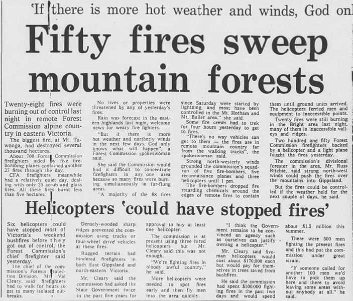
Rainfall in northeast Victoria in the six months prior to the summer of 1977-78 was only 298 mm, which was the lowest since 1938 when 254 mm fell. West Gippsland had 361 mm compared to 261 in 1938.
Unsurprisingly, the summer was characterised by a build-up of extreme fire danger with 606 outbreaks within the Fire Protected Area (FPA)
Sunday the 15 January 1978 was a day of Total Fire Ban with hot northwest winds from the early morning. Temperatures reached into the high thirties and low forties. All Forests Commission Districts had been put on high alert with crews on standby.
A typical strong southwest change crossed the State late in the afternoon with intense thunderstorms and lightning, but little rain.
Before the cool change arrived, the Commission was involved in nine other fires and was supporting the CFA at a grassfire near Paynesville where two CFA volunteers were killed.
Reports slightly differ, but the lightning caused a spate of at least 88 fires in the mountains, with most being reported on Sunday evening and throughout Monday from FCV towers and reconnaissance flights.
Most of the major fires were in the remote mountains of the Bright, Myrtleford, Heyfield and Maffra Forest Districts. The more accessible fires were quickly brought under control.
The Forests Commission was severely stretched, and Stage 2 of the State Disaster Plan (DISPLAN) was implemented, enabling the Army and Air Force to be called to assist the 850 Commission employees and contract timber industry workers. The Country Fire Authority, State Emergency Service, State Electricity Commission, Transport Regulation Board, Lands Department and the Police, also contributed significantly.
Eleven different FCV control centres were established (this was an era before AIIMS). The Army assisted with five mobile cooking teams at base camps. A total of 25 bulldozers were deployed including logging contractors.
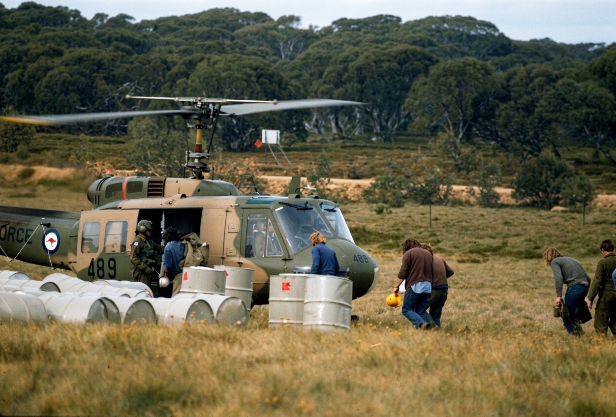
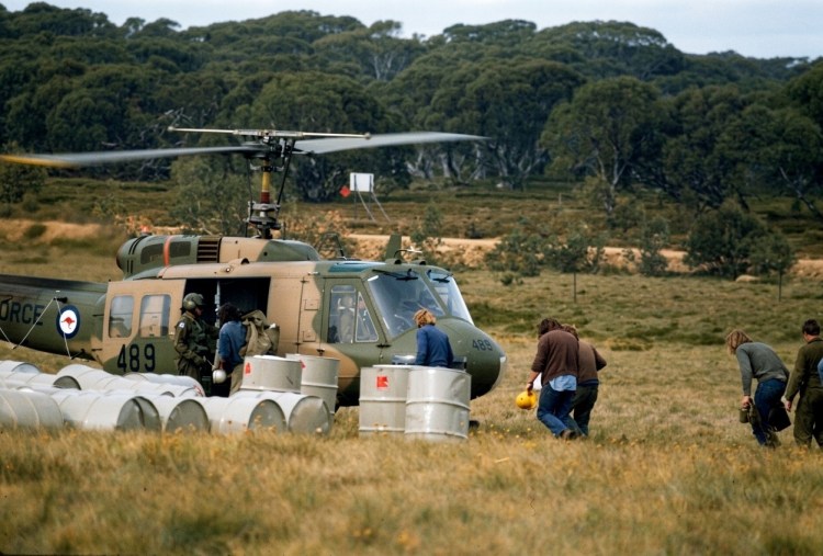
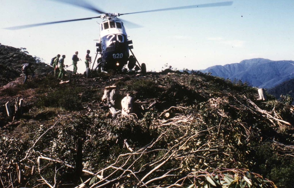
A notable feature of these fires was the very important role played by large military helicopters in moving men and supplies to combat multiple fires in rugged terrain.
This was probably the first time that large military helicopters had been used to support Australian firefighters on such a scale. It proved a “game-changer”
The Departmental Hughes 500 helicopter, which had been working at Toolangi, was immediately redeployed to Mt Beauty. Two other small helicopters were contracted by Monday evening. On Tuesday, the SEC had obtained access to an RAAF Iroquois which was then made available to the FCV under the State Disaster Plan arrangements. A further two heavy lift RAAF Iroquois, plus two lighter Army Kiowas arrived on Wednesday.
New helipads were cut, but crews were still walking up to four hours to get to some of the remote and inaccessible fires.
The RAAF Iroquois proved ideal for crew transport and could take up to 7 passengers and airlifted over 100 people over the course of the fires. They could also winch equipment and fuel drums. In one example at Mt Feathertop, the deployment times were reduced from a 6-hour drive, plus an arduous walk, to a short 15-minute flight back to the camp at Mt Beauty. This not only increased the amount of useful on-ground work, but reduced fatigue on crews and damage to vehicles.
But managing, refuelling and dispatching multiple crews and equipment to 12 different bushfires using the 8 helicopters proved a major logistical challenge for the Commission. But a lot was learnt for the future.
Five small agricultural aircraft were also used for firebombing. Four were based at Snowy Range and one at Mt Beauty, and together they dropped a total of 201 loads to support on ground crews using hand tools in the rough and steep terrain. While several fixed wing aircraft were also used for reconnaissance and transport.
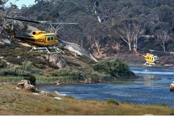
Helicopters were not used for firebombing in 1978 but were available five years later in November 1982 at Seaton when the NSCA at West Sale fitted a large Bambi bucket to one of its medium helicopters. Belly Tanks weren’t introduced until about 1984-85.
A lot of valuable equipment was lost during these fires and chainsaws were sometimes left in the bottom of gullies and never recovered.
Most fires were extinguished or controlled by the following Sunday when some light rain fell (< 5mm) across the fire ground making 4WD tracks slippery. However, the underlying drought index remained high.
Rain later in March 1978 eased the fire situation and the season came to an end with general rain during April.
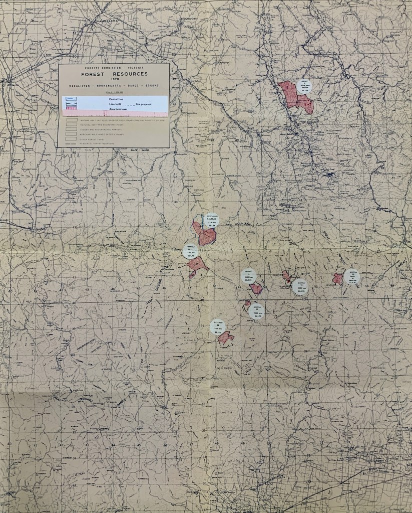
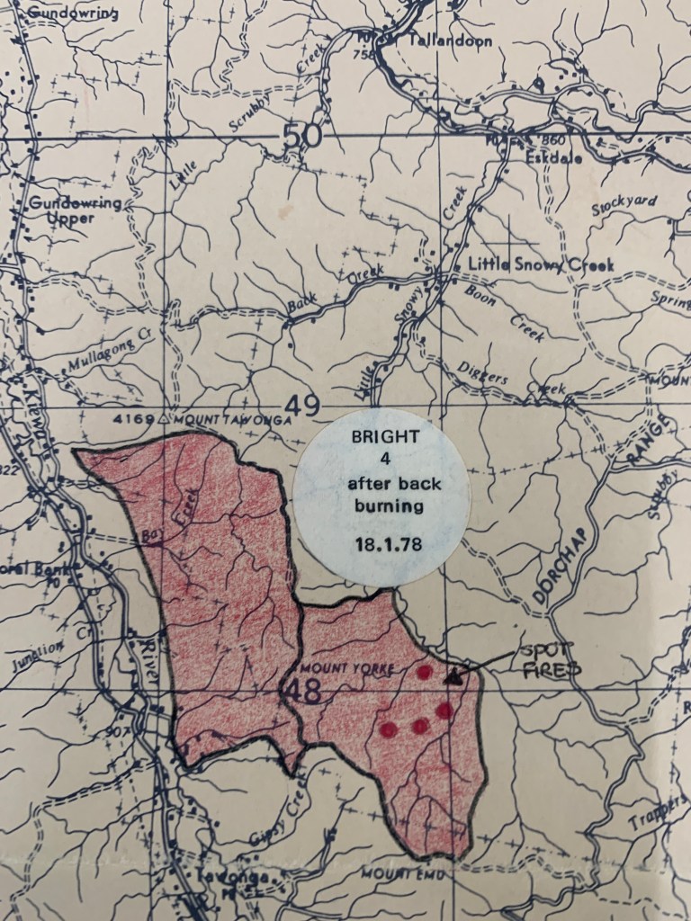
Unlike more recent alpine mega-fires, the total area burnt was only 23,000 ha, with 20,850 ha in 8 major blazes, and the largest at Mt Tawonga covering only 8,200 ha.
The Forests Commission’s Chief of the Forest Protection Branch, Val Cleary, made another public plea to the State Government for a more permanent fleet of bushfire helicopters. An internal review followed but with no direct change other than the existing single light helicopter on contract.
In the review of the fires, the FCV Chief Fire Officer, Barry Johnston, noted on 6 February 1978 –
Despite the amount of equipment employed, a large percentage of the perimeter of many fires had to be controlled by the use of hand tools. One particularly difficult fire on Mt Feathertop was entirely controlled by hand trails.
This work was facilitated by the number, training, willingness, youth and fitness of the additional men engaged earlier as additional manpower for firefighting.
Landscape Burning.
Importantly, in the decades prior to the summer of 1978 the Forests Commission had achieved a progressive increase in the area of Fuel Reduction Burning (FRB). While the annual figures varied according to the seasons, the rolling average had increased over the previous five years from about 150,000 ha to 200,000 ha per year.
This meant that nearly one million ha of forests had been treated by burning, leaving fuels at reduced levels and generally less than five years old. Most of this burning was low intensity in autumn along ridgetops in the eastern ranges.
There are some critics of FRB that claim that remote back country burning is ineffective and irrelevant. But in my experience, this prior landscape burning undoubtedly played a major part in the rapid success of the 1978 fire suppression effort.
Reducing fuel can also be very effective at giving safer access to crews, or as “anchor points” to tie in fallback lines and large-scale backburning when indirect attack is needed.
Importantly, most of the lightning strikes in January 1978 occurred on remote ridgetops in the lighter, sparser and recently burnt fuels.
The lower fuel levels not only reduced fire intensity, flame heights and rates of spread, but the more open forest allowed hand crews to gain access to the seat of the fires and then cut fire trails with hand tools or with small first attack dozers (FADs). This quick action combined with aggressive first attack kept most of the fires small and contained on State forests. No lives or private property were lost.
For all sorts of reasons, the area of landscape burning steadily declined from the mid-1980s. There was also a shift from prevention to response with a greater reliance on firebombing aircraft and indirect attack.
It therefore seems reasonable to conclude that the relatively small area burnt in January 1978 was due to the amount of landscape and ridgetop burning done in the previous five years.
Compare the 1978 outcome to the later megafires at Caledonia in 1998, the repeating alpine bushfires of 2002-03, 2005-06, 2006-07, Black Saturday in 2009, Aberfeldy/Seaton in 2013, the Snowy River Complex in 2014 and then Black Summer 2019-20, where preventative landscape burning had significantly declined.
And finally, there were so many bushfires that summer that the Forests Commission didn’t have enough money to pay all the overtime owed to staff. We had to wait until 1 July and the new financial year but then got whacked by the taxation department.
I know, because I was there…
Corryong – 1978.
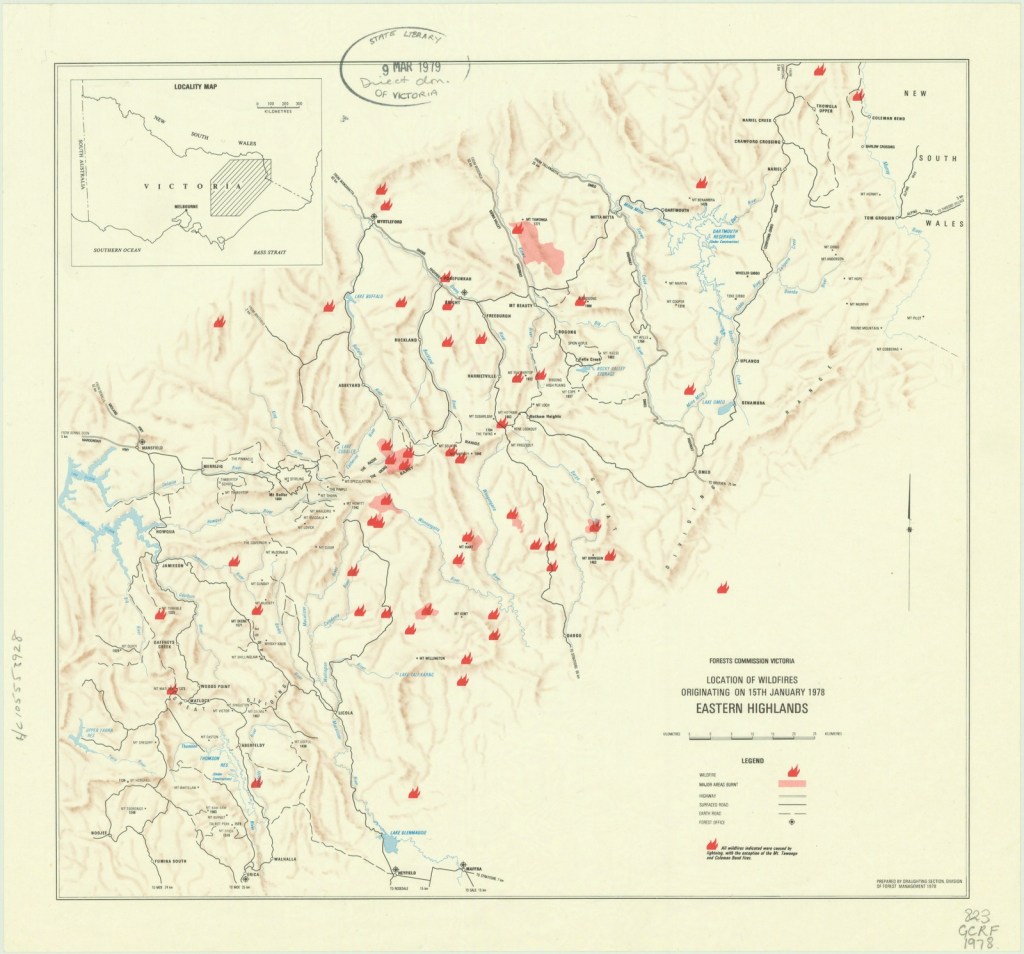
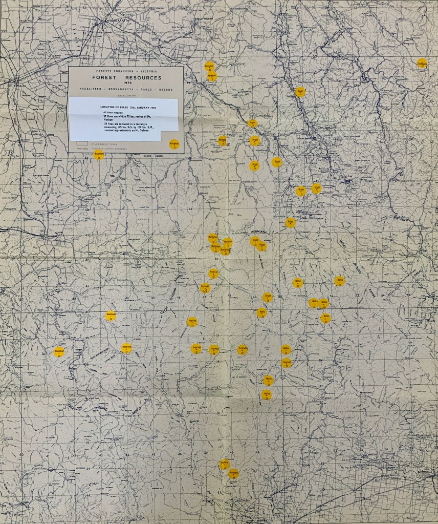
Three RAAF Iroquois helicopters were deployed to Victorian alpine bushfires in January 1978. This was probably the first time that large military helicopters had been used to support Australian firefighters on such a scale. It proved a “game-changer”. Snowy Range. Photo: Bryan Rees. FCRPA CollectionSLV http://handle.slv.vic.gov.au/10381/139854Location of fires on 15 January 1978. Most were within 75 km of Mt Hotham. Source: PROV FCV File 78/182The eight major fires. Source PROV FCV file 78/182The largest 8,200 ha fire at Mt Tawonga was controlled within a few days.
The largest 8,200 ha fire at Mt Tawonga was controlled within a few days.
Fuel Reduction Burning / Mosaic Burning / Landscape Burning / Asset Protection Burning / Hazard Burning / Slash Burning / Patch Burning / Ecological Burning / Back Burning / Cool Burning / Indigenous Cultural Burning… are all these terms more or less the same thing?
Well… it depends on the objectives of the burn…
Fuel Reduction Burning on public land is contentious and much of the heated debate is often misreported and confused depending on terminology and the objectives of burning.
Furthermore, Fuel Reduction Burning has created an unrealistic and simplistic expectation that it offers some kind of “magic bullet” that can prevent and stop the run of bushfires and guarantee the protection of life and property.
Some of this misinformation has been driven by the media, and some by strident critics, who readily find examples to highlight where recent fuel reduction burns have failed to stop damage by running bushfires in adjoining areas.
But there is also plenty of evidence where fuel reduction has made a big difference to controlling bushfires and saving life and property.
There are also some reasonable concerns about long term ecological impacts, habitat tree loss, smoke and the possible regrowth of flammable understory after hot burns.
Bushfire and forest management is often about balancing competing demands, but for the avoidance of any doubt –
The 2009 Victorian Bushfires Royal Commission clearly established the principal of the “primacy of life” which dictated that the protection of human life and community safety must be the absolute highest priority in all bushfire policy, planning, and operational decision-making.
So how long does Fuel Reduction Burning last?
How the bush responds to fuel reduction burning is complex and depends on the forest type and the fire regime.
The fire regime is generally described in terms of the long-term cycles and patterns of fire intensity, fire frequency and season of the year when the burning occurs.
Kevin Tolhust’s research work in the Wombat State Forest is probably one of the best and most recent scientific studies addressing this.
The effectiveness of fuel reduction burning also depends on how recent it was, the proportion of the total area burnt, the extent to which bark, fine and heavy fuels have been reduced and the pattern of the burnt fuel.
Importantly, fuel reduction burning aims to reduce and not eliminate forest fuels and ideally to protect tree crowns.
It’s true that the effectiveness of fuel reduction burning on the fine and surface fuels diminishes quickly after about 3-5 years depending on forest type.
But although surface fine fuels can build up again quickly, the overall fuel hazard usually increases much more slowly over 20 years or more as bark and elevated fuels regrow and reestablish. (See: Understanding Fuel)
Also, the first burn in older and long unburnt fuels (aka – reset burns) is always more difficult to achieve without crown scorch, particularly if heavy bark fuel like messmate has been allowed to accumulate and there are plenty of elevated ladder fuels. But subsequent burns in the lighter fuels can be carried out over a wider range of weather conditions with less scorch.
Burning to reduce fire hazard is not set-and-forget, it needs ongoing attention and maintenance. Following up with low intensity burning a few years after the first reset burn can reduce the flammable scrub regrowth to produce a more open understory and mosaic of fuel ages.
Similarly, burning in young and dense eucalypt regrowth can be difficult.
The Tolerable Fire Interval (TFI) is used when planning burns. It is the recommended time span between successive fires in specific ecosystems to allow local plant and animal communities to recover, reproduce, and maintain their ecological health. For example, it takes mountain ash (E. regnans) about 15 years to establish after major bushfires and set seed.
Burning prescriptions & crown scorch.
Burning prescriptions for dry Victorian foothill forest (without wiregrass) are typically in the range – FFDI < 10 on day one and < 12 on day two, drought index < 50, stable atmosphere, temperature 18-27 degrees, RH 35-70%, wind speed < 20 km/hr and fine fuel moisture content 9-16%.
The prescriptions help to set the limits of weather and fuel, sometimes called the “window of opportunity”, for conducting safe and effective operations.
Depending on Victoria’s summer bushfire season, the number of days suitable for fuel reduction burning, is very short, averaging only 50 to 80 days per year.
Ideally, the burn intensity should be low enough not to damage the tree crowns.
As a rule of thumb, scorch height is about six to seven times the flame height.
A low fire intensity of 500 kw/m was traditionally recommended as a threshold to fuel reduction burning in foothill eucalypt forests…. This equates to about 1m flame height with very slow Rates of Spread (ROS). At this lower level of fire intensity, crown scorch is limited to approximately 10% of the burnt area.
However, in my opinion, some of the present fuel reduction burning, particularly in asset protection zones on public land, often results in fire that is too hot.
From what I have recently observed, it’s now very common to see the ignition of continuous lines of fire around the perimeter (rather than well-spaced spot fires), followed by adding more fire inside the planned area (sometimes with helicopters). This gets the task completed quickly and efficiently but can create a very hot fire with a large unstable convection column which inevitably leads to excessive crown damage.
Importantly, in most Victorian foothill forests, removing or damaging the overstory tree crowns lets the sunshine reach the ground which can lead to a pulse of understory regrowth. In no time, the leaf litter, surface, elevated and ladder fuels return which has a major impact on overall fire hazard. Although, bark fuel can take 10-20 years to return.
I appreciate that many are reset burns with high accumulated fuel loads. There are also operational pressures to complete a large burning program within a limited window and to restrict burn-out times to about 24 hours. This reduces smouldering fuels that could reignite, lowers patrol and blackout effort, which allows crews to leave safely and move on to the next burn.
But it takes training, patience and discipline for firefighters to let the small fires trickle slowly to reduce crown scorch which damages the forest overstory. A driptorch in inexperienced and poorly supervised hands can quickly cause significant damage.
Burning masterclass.
Firstly, it’s worth noting that no matter how well you planned it, once the first match is dropped, the fire and flames behave in accordance with the fundamental principles of the chemistry of combustion – heat, oxygen and fuel – and do not follow ideology or intent – you have just lit a bushfire. Greg McCarthy (AFSM), Legendary Fire Behaviour Analyst.
But it is possible to “steer” the fire by having a sound understanding of weather, fuel, topography and fire behaviour.
The lighting pattern and time of ignition are critical to minimising fire behaviour and crown scorch.
Igniting small, well-spaced spot fires, and letting the fire slowly burn outwards in expanding circles and then trickle downhill and against the wind in the late afternoon or early evening, and well past the hottest part of the day, when the Relative Humidity (RH) is beginning to rise and the temperature, wind and FFDI is beginning to fall, will reduce flame height and fire intensity. (e.g. landscape burning).
Leaving burns in Asset Protection Zones to trickle overnight, and often unattended where there may still be some residual unburnt fuel, is now way too risky, especially after the escapes near Lancefield in 2003 and 2015.
But in my experience, landscape protection burns, which are well away from houses and settlements, the prescriptions are another matter.
In broadscale Landscape Protection Zones, the prescriptions allow for a much lower fire intensity with a patchy end result and minimal crown scorch.
Landscape burning should be done in autumn, as the wet weather approaches, rather than spring and moving into a drier summer. The FFDI should be less than 8; the Relative Humidity should be more than 45%; the atmospheric conditions should be stable; fuel moisture levels should be greater than 10%; with an upslope wind as preferable but not always possible.
Asset protection burns tend to be smaller and take less time, but some landscape burns cover very large areas and are done in stages, so they may need one to two weeks of continuous stable weather to set up, light and patrol. They also often require moving crews, equipment and aircraft from across the State to take advantage of the weather conditions, which presents a bundle of logistical issues.
The boundaries for landscape burns do not need to be as hard (e.g. constructed control lines, major roads or strategic breaks) but rather can be left unbounded to extinguish against natural boundaries like rocks, damp creeks or shady areas on southerly aspects.
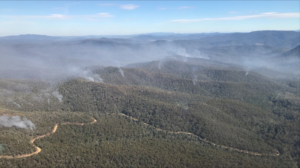
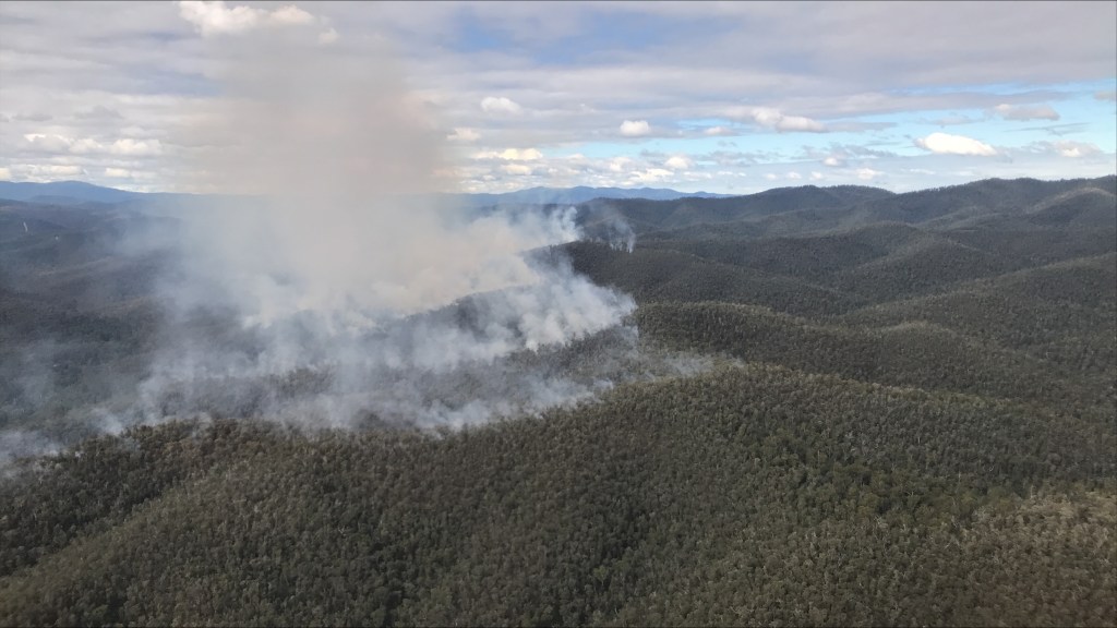
The areas targeted for ignition with landscape burns are generally a smaller subset of the gross area identified for treatment, with a focus on the top third of the ridges, on the drier north side.
Burning Risks.
Make no mistake, fuel reduction burning is complex and risky. Many considerations are made including – burning objectives, prescriptions, weather outlook, nearby community assets, fuel type, fuel quantity and arrangement, bark type, Rate of Spread (ROS), flame height, topography, burn area and perimeter, available resources, lighting pattern, ignition timing and techniques, smoke drift, hazardous trees, residual burn out time, areas to be protected, safety zones and fall-back options.
Prevention of bushfire is much cheaper and less damaging than bushfire suppression, but it’s very hard to judge the effectiveness of avoiding something that didn’t ever happen. It’s a bit like assessing preventative medicine.
The key to success is having all the preplanning and preparation done, with approvals and notifications in place, and then giving staff the freedom to nimbly take advantage of local burning opportunities when they occur, whatever the season, or time of day.
But the current requirement to notify neighbours and other authorities (e.g. VicRoads etc) at least 48 hours before ignition can considerably hamper any agility.
Fuel Reduction Burning can and does go wrong (but very infrequently) and the community, armchair experts, politicians and the media are quick to criticise and are very unforgiving.
A major turning point came on 19 November 1994, when a Fuel Reduction Burn at Moggs Creek on the Great Ocean Road got away. What had been intended to protect homes in the highly flammable coastal scrub, instead destroyed or damaged several of them. Hundreds of residents were evacuated, lawyers became involved, and the fire agencies were left ducking for cover.
The Moggs Creek fire rewrote the terms on which fuel reduction burns could be lit, effectively putting a damper on the practice for the next decade. And often, it simply became easier not to burn at all.
Other notable examples of escaped planned burns that reinforced organisational risk aversion include Cobaw in April 2003, Wilsons Promontory in March 2005 and Lancefield in November 2015.
Each escape was investigated and new systems and controls introduced (some would say too many).
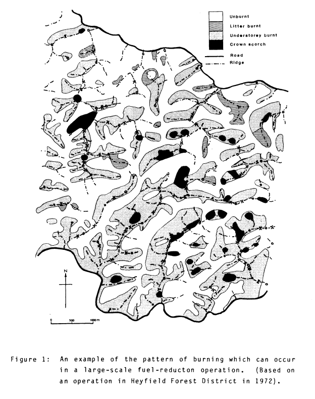
FRB aims to reduce and not eliminate forest fuels. A good example of the pattern in broad scale FRB. Based on an operation in Heyfield in 1972. Source: Rawson et al (1985)
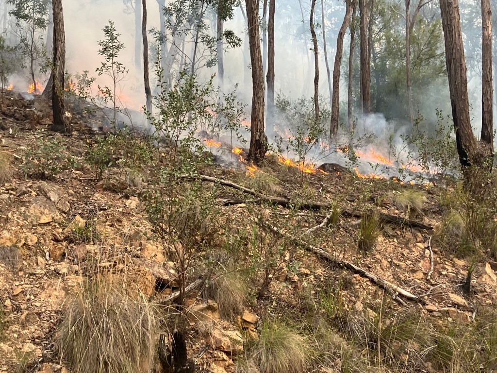
Low flame heights don’t scorch the tree crown. Photo: DEECA 2026
Well controlled patch ignition with a series of small spot fires Source: Howitt Society.
An excellent example of low intensity, multi age and unbounded ridgetop aerial ignition at Orbost. Photo: DEECA 2026Low flame heights with no elevated (ladder) fuel. Moisture content around 15%. Photo: Lee Gleeson – Cobaw 2003.
Slow moving, low intensity, multi age and unbounded ridgetop aerial ignition at Orbost. Photo: DEECA 2026
The effectiveness of fuel reduction burning is often hotly debated. There are many myths and fallacies. Its effectiveness as a fire break depends on many complex factors including how hot the bushfire was and how recently the fuel reduction burning was done. These DELWP photos are of Painted Line Track north of Orbost. The main bushfire was hot and burnt on 30 December 2019. The green areas on the left were subjected to a fuel reduction burn 20 months earlier in April 2019. In this case the fuel reduction burn has completely stopped the run of the crown fire at the boundary of the fuel reduced area. There is about a 20-metre strip of trees scorched by the heat of the crown fire and then the fire went out. Crown fire cannot be sustained if the ground fuels are at low levels. The effectiveness of fuel reduction burning as a firebreak diminishes quickly after about 3-5 years.
Reducing the overall fuel load, particularly bark fuels, together with changing near surface and elevated fuel arrangement by burning or mechanical treatments like slashing or mulching are the only large-scale techniques that forest managers have available to them of lessening bushfire behaviour.
Fire weather cannot be controlled, whereas fuels can (with some caveats).
Section 62(2) of the Forest Act (1958) requires –
The Secretary must carry out proper and sufficient work in State forests, national parks and on protected public land –
(a) for the immediate prevention and suppression of fire; and
(b) for the planned prevention of fire.
This legal obligation on DEECA / FFMVic is very onerous.
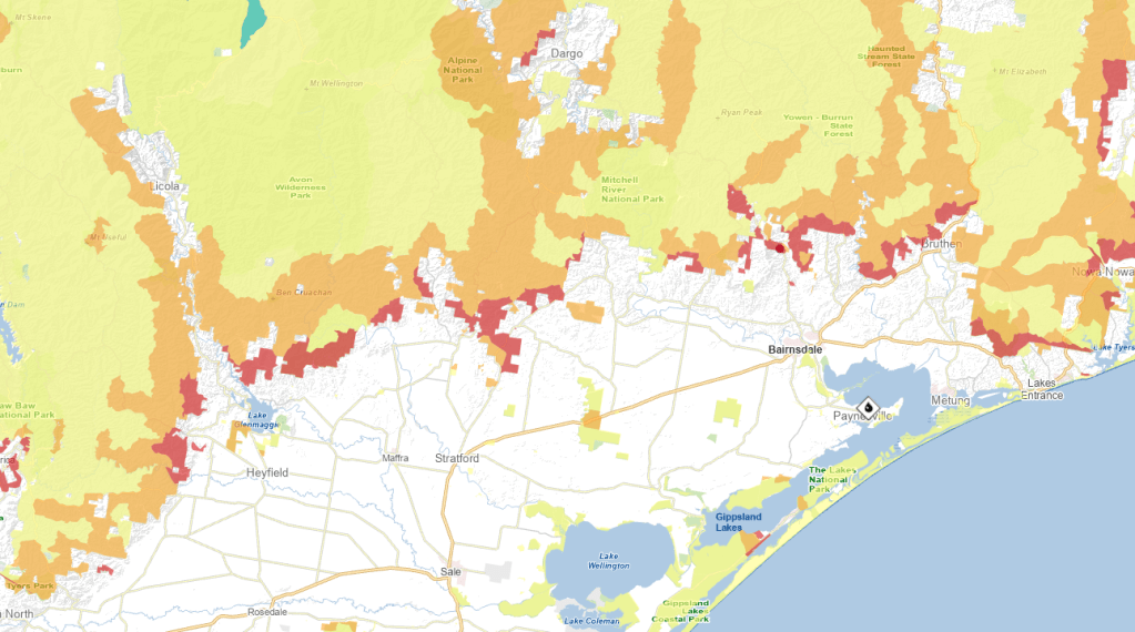
In Victoria, there are a couple of zones used to plan burns on Protected Public Land (National Parks and State forests).
Asset Protection Zone – usually done more frequently close to private property and settlements to reduce radiant heat and ember attack. In addition to burning, the works may include road and bridge upgrades, strategic fuel breaks, mulching, mowing and treatment of dangerous trees.
Moderation Zone – designed for the middle region to reduce the speed and intensity of bushfires and to reduce ember attack.
Landscape Zone – fuel is reduced across a broader landscape, often on the dry ridges in the remote backblocks.
Exclusion Zone – where planned burning is avoided, such as wet mountain forests, alpine meadows and rainforests.
There are two very important things that recent Fuel Reduction Burning (FRB) can offer fire fighters on the ground.
Fuel breaks to stop or slow a running fire using direct attack.
Lower fuel hazard to give more options for safe access, control lines and anchor points using indirect attack.
1. Fuel Reduction Burning as a fuel/fire break.
Fuel Reduction Burning to reduce fuel to create a fire break (or more correctly fuel break) is a well proven means of lowering fuel hazard.
However, the effectiveness of the fuel reduction burning to stop or slow the spread of bushfire depends on many complex factors. They include how hot the bushfire is at the time (flame height and fire intensity), how fast it is moving (Rate of Spread), how recently the fuel reduction burning was done, and what proportion of the fuel was removed.
The location, size, depth and shape of the fuel reduced area are also important, particularly if there is long distance spotting ahead of the main front.
The weather at the time of impact of the main fire, particularly temperature, wind speed and fuel dryness, is critical to the final effectiveness of the fuel break.
It’s also true that fuel reduced areas can be ineffective at stopping the run of fast-moving, high intensity bushfires where the weather, and not fuel, becomes the main driver of fire behaviour and long-distance spotting is evident (e.g. FFDI > 50).
No amount of heroic suppression effort by on-ground crews or aerial firebombers can overcome the deadly combination of extreme weather, rugged terrain and heavy accumulation of fuels when a bushfire escalates to landscape scale.
But these extreme fire conditions don’t occur as often as many might believe. It’s just when the media takes an interest.
While there is high variability over the summer danger period, benign weather conditions with Low to Moderate (FFDI < 24) are much more common than not. Nights are also generally cooler with moister air (high RH) and lower wind speeds leading to lower FFDI. Higher fire danger days occur more often in northern Victoria.
Average number of “Very High” fire risk days (FFDI > 25) in Victoria per year (1973-2016). Source: CFA
Walpeup (representing far northwest Victoria) – 60
Wangaratta (representing the northeast) – 17.5
Bairnsdale (representing the southeast) – 3.5
Mortlake (representing the southwest) – 12
Melbourne (representing central Victoria) – 12.5
The summer fire season generally stretches over 5 or 6 months (150 – 180 days) with a peak generally from December to February when most of the Total Fire Bans (TFBs) are imposed. For example, during the 2023–24 season, there were 11 TFB days declared, which often coincided with Extreme fire risk (FFDI > 50), across the State.
Fuel reduction burning slows the spread of bushfires, reduces their intensity, and lowers the potential for spot fires – CSIRO.
But the critics of fuel reduction burning often focus on losses and damage caused during extreme weather conditions and readily cherry-pick to find examples to highlight where recent fuel reduction burns have failed to stop damage by running bushfires in adjoining areas.
However, there are plenty of examples where recent FRB has stopped or slowed the forward Rate of Spread (ROS) of bushfires and given firefighters a chance to gain access and control it. There are also some spectacular examples where it has stopped the run of a hot bushfire dead in its tracks (e.g. Painted Line Track, 30 December 2019 – Orbost).
In most cases, first attack is successful and bushfires are quickly contained without fuss or fanfare. But these impressive efforts by fire crews go mainly unnoticed by the community and unreported by mainstream media. For example –
In 2023-24, a total of 1,179 fires occurred on Victoria’s State forests and National parks and 92% were kept to less than 5 ha in size, and a whopping 96% were contained by 8.00 am on the day following detection.
There are also a handful of examples where long unburnt and wetter forests have stopped or slowed a running edge. During the Black Saturday bushfires in 2009, a slow-moving fire burnt slowly overnight through the thick undergrowth in the wet 1939 regrowth mountain ash forests on the Black Spur.
But conversely, the 2009 Black Saturday fire in the Wallaby Creek catchment burnt and killed ALL the old the mountain ash forest (some stands predating 1770), but in other nearby areas, there was a lower rate of spread, severity and crown scorch which occurred on the SW wind change later in the afternoon.
2. Fuel Reduction Burning giving options for safe access and control.
Once a bushfire becomes established in heavy and continuous fuels, under adverse weather conditions, the scope for safe direct attack rapidly narrows.
But weather alone does not shape bushfire destiny.
Preparedness, early detection, with quick access by crews, machinery and aircraft, combined with aggressive first attack, are proven keys to early success.
Very importantly, areas that have been recently fuel reduced can give a better chance of control using indirect attack as well as providing a safe refuge for on-ground fire crews.
In conjunction with roads and strategic firebreaks, areas that have recently been fuel reduced give options for anchor points for control lines and safe access for large scale backburning.
Fuel reduced areas can help stop a 1,000-ha fire becoming a costly and prolonged 100,000-ha campaign fire with a huge perimeter to be controlled.
Reducing fuel has been shown repeatedly to help keep bushfires small and contained on public land and stop them from threatening private land, farms, towns and settlements.
Bushfire Management Zones – Gippsland hinterland Asset Protection Zone – dark orange near settlements Moderation Zone – light orange Landscape Zone – yellow
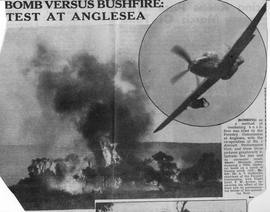
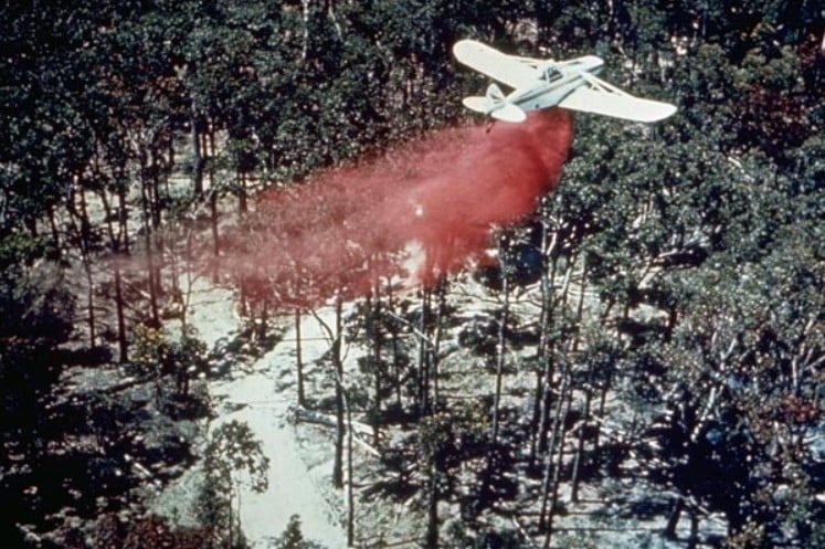
By the early 1960s, there was a growing recognition by Australian foresters of the need for large-scale controlled burning to reduce fuel loads.
Alan McArthur published his landmark paper, “Controlled burning in eucalypt forests” in 1962. Leaflet No. 80 proved a turning point for forest and fire managers across Australia.
It also became evident that incendiaries dropped from aircraft was the most efficient way to treat large areas during the brief windows of suitable weather.
Two separate aviation developments followed – a fixed-wing technique by the CSIRO in collaboration with the Western Australian Forests Department, and a helicopter technique by the Forests Commission in Victoria.
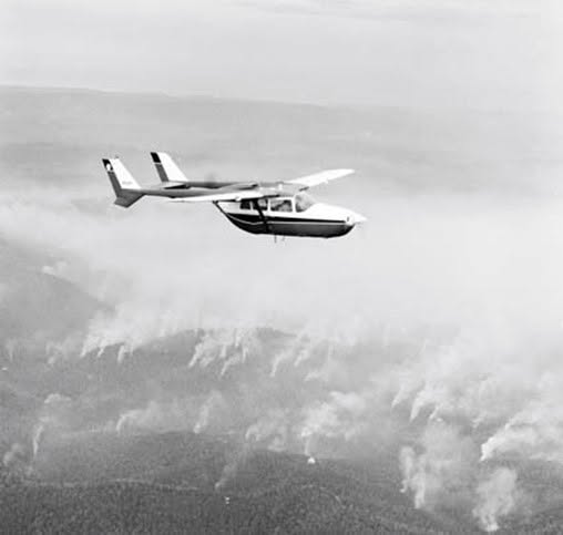
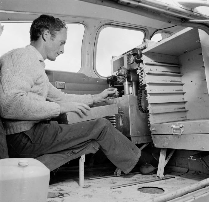
The Western Australians and the CSIRO pioneered aerial ignition in the early 1960s and developed a semi-automatic machine which dropped small incendiary capsules. The first operational trial was from a fixed-wing Cessna 337 at Manjimup WA in December 1965.
Later in April 1969, the Forests Commission borrowed the CSIRO machine to carry out fuel reduction burning at Orbost. The success prompted the purchase of their own incendiary machine.
Running in parallel with the CSIRO work, the Forests Commission experimented with Delayed Action Incendiary Devices (DAIDs). These were large double-ended matches with a length of safety fuse between, which were dropped by hand from a helicopter.
Helicopters were better suited to Victoria’s mountainous terrain and irregular burning boundaries, with slow flying and excellent manoeuvrability, enabling accurate placement of incendiaries and control over the lighting pattern.
The development of DAIDs, together with the engagement by the FCV of a Bell 47G helicopter on a permanent contract in December 1965, a first for any Australian Forestry agency, was partly in response to public criticism of the Commission about the lack of fuel reduction burning on State forest in the wake of the disastrous 1965 Gippsland bushfires.
The first test using DAIDs was with the Bell 47G on 4 October 1967. A few months later in February 1968, DAIDs were used to light-up a large backburn to control a 20,000-ha bushfire in north-east Victoria. This is believed to be the first time that this technique had been tried anywhere in the world.
But DAIDs were dangerous so needed to be stored in a metal box outside the helicopter along with a disposable striker patch attached with a quick-release pin to a special half-door.
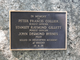
Sadly, the crash of a helicopter conducting routine aerial ignition near Wandiligong on 19 April 1978, with the tragic death of two forest officers and their pilot, profoundly shook the small “Fraternity of Foresters”. There is a memorial to them at the Bright Arboretum.
But the crash led to better accident insurance for staff involved in air operations, the end of DAIDs and the adoption of the safer Premo “ping-pong ball” aerial incendiary machine.
Overall, the development of aerial ignition techniques by the Forests Commission from the mid-1960s resulted in a steady climb in the area burnt each year…. peaking at 477,160 ha in 1980-81, and with an impressive 10-year rolling average of 224,500 ha (or 3% of the total public land estate).
G. W. van Didden (1983). A new incendiary machine for aerial prescribed burning. WA Forest Dept. Technical Paper N0 4.
Aerial Ignition in Western Australia with a Cessna 337. The first trial of the CSIRO incendiary machine was at Manjimup in December 1965. Source: Australian National Archives. https://vimeo.com/135628812
The rack on the right held trays of incendiaries which were manually loaded by the operator. The spacing of the ignitions was about 200 m and could be controlled by adjusting the speed of the aircraft to about 100 knots and adjusting the dwell between drops to one every four seconds. Great emphasis was placed on maintaining an even grid pattern, but this proved a demanding task flying 400 feet above the ground and various techniques were tried. Source: Australian National Archives.
Incendiary capsules contained granules of potassium permanganate which were injected with ethylene-glycol. A delayed chemical reaction resulted in a small fire on the ground lasting for some 30 seconds. Source: Australian National Archives
DAIDs (Delayed Action Incendiary Device) had an overall length of 180 mm, striker end length – 10 mm. Ignition end length- 80 mm, then a layer of high melting point wax (to prevent accidental ignition when rubbing together in transit). Both ends coated with modified match head compound with safety fuse exposed length between coated match ends. There was a 17-second delay from when the small end was struck to an intense flaming of the large end, which lasted for 40 seconds. Photo and description: Barry Marsden.
Delayed Action Incendiary Devices (DAIDs) were struck on the side of this Bell 47G helicopter and dropped by hand. DAIDS were kept in a box on outside of the door with a quick-release mechanism. The rate of ignition approximately 300 acres per hour. Photo: FCRPA Collection – circa 1974.
Aerial ignition was used for the first time in the world to ignite a large back burn to control a large 20000 ha bushfire in north-east Victoria in February 1968. Source: FCV Annual Report.
The crash of a departmental helicopter involved in burning operations at Wandiligong on 19 April 1978 with the tragic death of three people shook the small “Fraternity of Foresters”. But it led to the end of DAIDS and the adoption of the much safer Premo “ping-pong” ball incendiaries. Memorial at Bright Arboretum. Photo: Peter McHugh 2020.
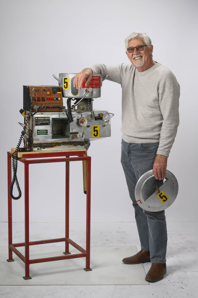
Legendary fire equipment wizard, Barry Marsden, standing proudly with probably his most famous invention… the aerial incendiary machine…
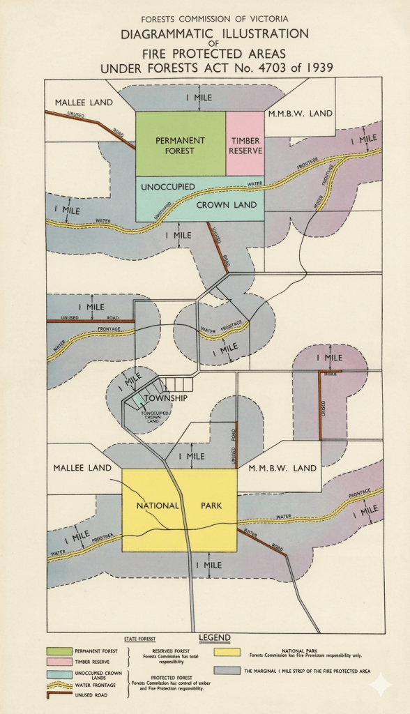
One lasting consequence of the 1939 Stretton Royal Commission was a revision of the Forest Act in 1939 which handed the Forests Commission the additional responsibility for bushfire protection on all public land including State forests, National Parks and unoccupied Crown Lands, plus a buffer extending one mile beyond their margins onto private land. (A.K.A. – The Marginal Mile).
The land was known as the Fire Protected Area (FPA) and the Forests Commission’s fire protection responsibilities leapt overnight from 6 to nearly 16 million acres, or to nearly one third of the State.
The rural and urban brigades of, what was to become, the Country Fire Authority (CFA) in 1945, took responsibility for all the remaining private land, or “Country Area”, of Victoria, but it excluded the Melbourne metropolitan region, where the Metropolitan Fire Brigade (MFB) took the lead.
The Bush Fire Brigades Act (1939) provided that:
The captain of any bushfire brigade… with or without consent… may enter upon any [private] land and abate or remove any fire hazards.
Similarly, forest officers were given this power in the Fire Protected Area in the revised Forest Act.
The MMBW was deemed a “public authority” under the CFA Act and took responsibility for fire protection in Melbourne’s water catchments. This arrangement changed with the creation of the National Park and fire protection was then managed by agreement between Parks Victoria, DEECA and Melbourne Water.
The SEC had a similar arrangement for the Kiewa Valley which was “vested”. The Latrobe Valley was deemed private land, and the SEC maintained their own equipment as an industry brigade, which fell under the CFA legislation.
The FPA was revised in the review of the 1958 and much of the marginal mile, particularly with fragmented public land, has now been excised.
When the Forests Act and Country Fire Authority Act were reviewed in 1958 and clearly enshrined the role of the two agencies and the Chief Fire Officers into complementary legislation.
The CFA took responsibility for fire suppression on “Country Victoria” leaving the Forests Commission to focus on the public land estate such as State forest and National Parks, which amounted for the remaining one third of the State.
After 1939 bushfires the Fire Protected Area (FPA) leapt from 6 to 16 million acres, or to nearly one third of the State. This diagram was used to assist in identifying areas within the marginal mile of the FPA. Source: John Nicholson. (enhanced)
Backburning to build or thicken a control line from a strategic fuel break, road, ridgeline or 4WD track is a common and effective dry firefighting technique, particularly in remote and rugged country.
But indirect attack using backburning increases overall fire size and therefore fire perimeter. It also introduces more fire into the landscape, often under unfavourable fire weather conditions.
Backburning is often done in conjunction with aerial ignition and burning out the remaining fuels.
However, backburning ahead of a fast-moving fire front is often a last resort strategy, one that requires great skill and courage, as well as a generous dollop of good fortune to execute successfully, which presents a serious dilemma for all forest firefighters.
Backburning operations can be a spectacular success at stopping the run of bushfire, but many a backburn has either got away or split the main fire to create a troublesome second fire front.
It also should be noted that there is a huge difference between Fuel Reduction Burning(FRB) which is done in the cooler months, under prescribed weather and fuel conditions and within a predefined boundary, compared to a backburn constructed as a control line (often under difficult fire weather conditions and with limited time to plan and prepare), to stop the passage of a running bushfire.
A recent example of pre-dawn backburning during the 2020 Gippsland fires. Note the three parallel lines of ignition which aim to give “depth” to the edge and draw the fire back away from the control line. Photo: Wayne Morris.
Victorian foresters were initially trained in European traditions and believed fire had no place in the forest.
Like many early settlers, colonial foresters only saw bushfire as a threat, particularly to young regrowth, and sought to eliminate it altogether.
A fire exclusion policy, though well-intentioned, shaped forest management for decades with mixed results. Early Forests Commission annual reports are full of references to the lengths of fire breaks built and maintained.
Firebreak work was a big priority during the unemployment (susso) programs in the 1930s. But they were laborious and costly to build and maintain with only simple hand tools available
By the late 1930s, a network of firebreaks had been built to protect the forests across the State, but their effectiveness was severely challenged during the devastating 1939 bushfires.
It was soon realised that firebreaks weren’t enough on their own, which led to a shift in the 1960s to Fuel Reduction Burning (FRB), particularly when aircraft and aerial ignition became available.
It’s true that most fire breaks, or more correctly fuel breaks, are generally ineffective at stopping the run of fast-moving and high intensity bushfires (FFDI > 50), particularly if there is long distance spotting ahead of the main front.
However, these severe bushfire weather conditions don’t occur as often as many might believe. It’s just when the media seems to take an interest. For example –
Over a six-month fire season in Gippsland (180 days) there are, on average, only 3 or 4 days where the fire danger is “Very High” (FFDI > 24) and even fewer spike days of “Extreme” bushfire danger (FFDI >50). And then there are the cooler nights.
Strategic roadside fuel breaks, along with areas that have recently been fuel reduced by burning, have the effect of breaking up the extensive areas of uniform forest fuels on public land into manageable blocks.
Together, fuel reduced areas and strategic breaks have consistently proven very effective at providing access and safety zones for first attack crews and creating anchor points for control lines and large-scale backburning to contain the fire.
In most cases, first attack is successful and bushfires are quickly contained without fuss or fanfare. But these impressive efforts by fire crews go mainly unnoticed by the community and unreported by mainstream media. For example –
In 2023-24, a total of 1,179 fires occurred on Victoria’s State forests and National parks and 92% were kept to less than 5 ha in size, and a whopping 96% were contained by 8.00 am on the day following detection.
Hundreds of kilometres of new control and fallback lines were hurriedly built and widened along ridge tops, roads and old 4WD tracks during the 2002-03 alpine bushfires. Many were rehabilitated only to be reopened and lengthened in the subsequent 2006-07 bushfires. This was both costly and futile. A permanent, well-designed, and well-maintained network was clearly needed.
Building a permanent network of strategic fuel breaks (20 m – 40 m wide) on State forests and National Parks in remote locations, along with asset protection breaks (40 m wide) near settlements, was one of the key outcomes of the 2009 Black Saturday Bushfires Royal Commission.
The presence of large and hazardous trees on the boundaries, particularly eucalypts with fibrous or ribbon bark, can compromise the effectiveness and safety of the breaks. They are even more effective if the forest behind the edge of the cleared break is thinned (50 m – 100 m) and the understory fuel reduced by burning or mulching. (See: Understanding Fuel).
Strategic fuel breaks are contentious but much of the debate is often lopsided or misreported with strident critics quick to point out examples where they have failed.
However, based on decades of experience in Gippsland as a senior firefighter, strategic fuel breaks and forest roads have repeatedly proven very useful at keeping remote bushfires small and contained on public land.
Some media commentators have not helped either, by creating an unrealistic and simplistic expectation that, together with fuel reduction burning, the breaks are some kind of “magic bullet” that can prevent and stop the run of serious bushfires and guarantee the protection of life and private property… which they are not…
Furthermore, I do not accept the claim, made by some detractors, that remote strategic fuel breaks and landscape fuel reduction burning offer little or no fire protection benefit, or that widened roads act as wind tunnels.
For example, a notable feature of Victorian summers are the strong cold weather fronts and dry thunderstorms that roll across the eastern mountains from the southwest during the late afternoon, particularly after a hot windy day, sometimes bringing thousands of lightning strikes. (See: Bushfire Flume).
Following the passage of the storms it was not unusual that by the evening, or early the next day, as reconnaissance detection flights resumed and fire towers went back up, to get that familiar sinking feeling as a steadily increasing number of bushfires popped up on the incident battle board, often at some very remote and inaccessible places.
When confronted with these widely scattered, but still relatively small bushfires, one of my first requests as a Level 3 Fire Planning Officer or Controller – after the situation reports and the weather forecasts – was for the latest fuel reduction burning and strategic road maps to identify initial priorities, control lines and fallback options.
Importantly, unless they were quickly attacked and contained during the mild and stable weather in the days after the thunderstorm, these small lightning strikes had the capacity to overwhelm firefighting resources as they grew, and even joined up, to become an unstoppable bushfire complex. (e.g. 2002-03, 2006-07, 2013, 2019-20).
Once the fuse was lit, virtually no amount of heroic suppression effort by on-ground crews or aerial firebombers could overcome the deadly combination of extreme weather, rugged terrain and heavy accumulation of fuels when these campaign bushfires escalated to the landscape scale. (See: Gippsland Zig Zag).
Helicopters capitalise on the three main advantages of aircraft… speed, access and observation…
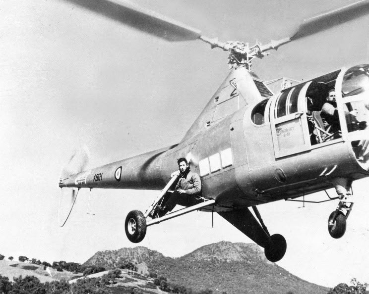
The RAAF’s first helicopter, a Sikorsky S-51 Dragonfly (A80-1), was test flown at Laverton Air Base on 9 October 1947.
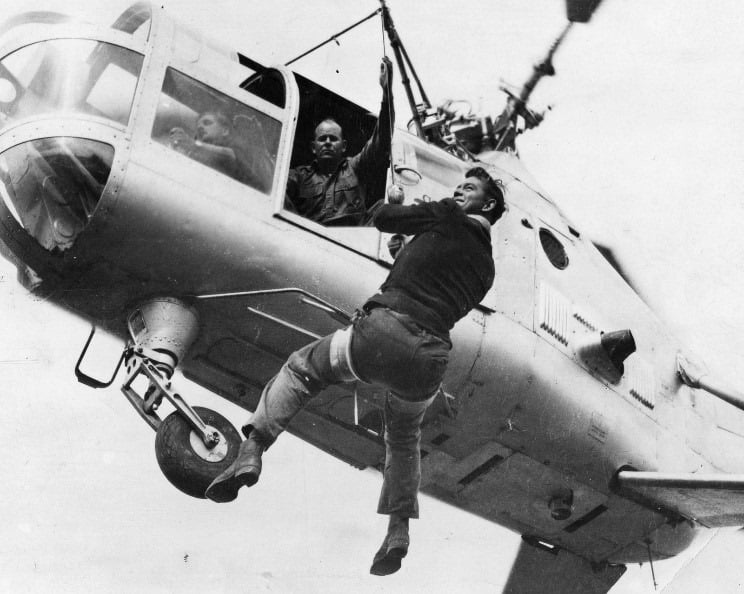
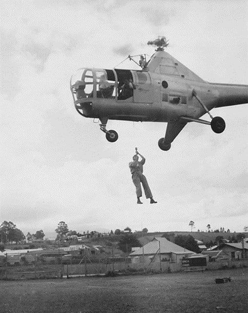
In May 1949, in an Australian first, the Forests Commission winched firefighters from the hovering Dragonfly.
The Sikorsky proved very versatile and was later used for reconnaissance and mapping missions as well as deploying fire crews and their equipment into remote locations.
Based on these successful RAAF trials, as well as experience in the 1965 Gippsland bushfires, the Commission contracted its own Bell 47G in late 1965, which was also an Australian first for any forest agency.
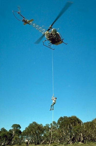
Development of rappelling techniques at Snowy Plains and Tallangatta followed, which led to operations based at Heyfield with a two-man crew to quickly attack small fires in remote locations.
The Heyfield rappel crew was another Australian first and remained in place for the following two fire seasons but lapsed after concerns from the Civil Aviation Safety Authority (CASA) about the stability of the small and underpowered Bell 47G.
However, the Forests Commission continued to expand its use of light helicopters throughout the 1960s and 1970s for transport, sling-loads, reconnaissance, mapping, aerial seeding, spraying, Forward-Looking-Infra-Red (FLIR) cameras and developing aerial incendiary techniques.
A notable feature of the January 1978 fire season was the very important part played by larger military helicopters. Three RAAF Iroquois were used to move crews and supplies across the Victorian alps. This was probably the first-time military helicopters had been used to support Australian firefighters on such a large scale.
It was a game-changer…
The National Safety Council of Australia (NSCA), which was based near Sale in Gippsland, expanded its aerial operations significantly during the 1982-83 bushfire season.
In 1982, after nearly 18 years absence, rappelling operations recommenced using larger and more powerful NSCA Bell 212 and Bell 412 helicopters.
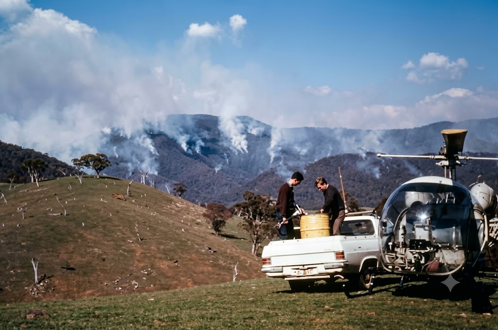
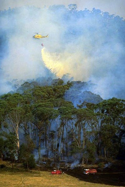
A NSCA Bell 212 with a 1700 litre water bucket was first used at the Seaton fire in November 1982. If a water source was nearby, the bucket proved very effective at supporting ground crews at knocking down spot fires and supressing flames.
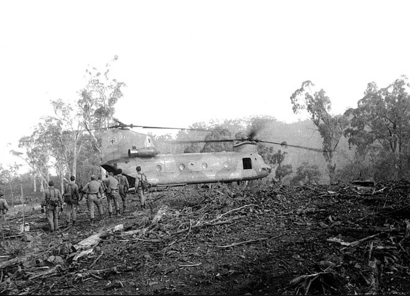
Also, during the Ash Wednesday bushfires in 1983, a 30-passenger RAAF Chinook helicopter deployed firefighters, relief crews and fuel for bulldozers in difficult terrain at Nug Nug near Mount Buffalo.
The NSCA later conducted its first firebombing operations in Victoria using Canadian designed helicopter bellytanks in 1984-85.
Valuable lessons about using aircraft, particularly at the 1985 bushfires at Mt Buffalo, led the Department to initiate national training programs and accreditations for aircraft officers, observers, incendiary operators, hot refuelling crews, retardant mixers as well as specialist Air Attack Supervisors (AAS).
The Erickson Sky Crane first came to Victoria in 1997-98 and could lift nine tonnes of water.
Modern firefighting operations are generally conducted with a mixture of both fixed and rotary wing helicopters. But helicopters have a major advantage over fixed wing aircraft of being able to hover over the fire and accurately drop water, foam or retardant. They can pick up water from shallow dams or rivers using snorkels to fill their belly tanks or dipping a collapsible bucket suspended on a line. Helicopters can also be used for reconnaissance, air attack, infrared mapping, dropping supplies and delivering crews.
Depending on forest type, fuel load, understory thickness and slope, a large Type 1 helicopter like a Sky Crane can construct, suppress and hold about 500m of control line per hour. A mid-size Type 2 Helicopter like a Bell 412 with a bucket or belly tank might only achieve 200 m.
For comparison, the sustained rate to construct and hold fire control lines by hand crews is between 5 and 20 m per person per hour.
The operating costs of medium helicopters are much higher than fixed-wing aircraft carrying similar loads but their flexibility, accuracy and ability to pick up retardant close to the fire can make them more cost effective in many situations.
They are particularly effective in tight mountainous terrain and providing close support to knock down flames for ground crews working near the fire edge. But there is no substitute for “boots-on-the-ground”.
But the greater use of heavy-lift helicopters forced major changes to fuel and retardant handling. Medium helicopters like the Bell 412 require about 600 litres of fuel per hour, or three standard 200 litre drums, whereas heavy-lift helicopters like the Erickson Air Crane were fitted with massive 4,900 litre fuel tanks and guzzled a staggering 2,000 litres per hour.
Helicopters have continued to evolve and are now an integral part of bushfire suppression.
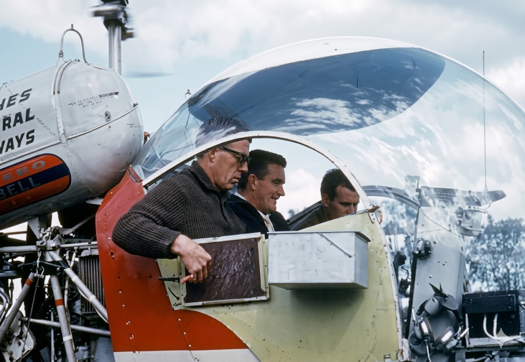
Winching trials with RAAF Sikorsky S-51 Dragonfly in 1949. Photo: State Library of Victoria.
The Forests Commission pioneered Australia’s use of aircraft for firefighting and crew transport. This photo was taken at Erica in 1949. Source: State Library of Victoria.
Forests Commission crew transport and emergency evacuation trials using a RAAF Sikorsky S-51 Dragonfly near Eildon Weir in May 1949. This particular aircraft, serial A80-1, was the very first helicopter to arrive in Australia in 1947. Photo: State Library of Victoria.
A newspaper report from Mansfield in north-east Victoria. May 1949. Source: FCRPA
Rappel trial in 1965 at the Snowy Range with a Bell 47G. Ian Betts, Heyfield Field Staff, dangling on the rope. Source: FCRPA Collection
The summer of 1984-85 in northeast Victoria had the largest single aerial firefighting operation in Australia up to that time. Up to 20 helicopters and 16 fixed-wing aircraft including Navy Wessex and RAAF Bell UH-1 Iroquois. Photo – NSCA Bell 205 – Buckland Valley. Source: Bryan Rees.
NSCA Bell 205s filling fitted with Canadian belly tanks at Lake Catani on the Buffalo Plateau. February 1985. Photo: Bryan Rees
Loading crews into a Navy Wessex at Mt. Murray in January 1985. Mt. Feathertop is in the background. These fires were the largest single aerial firefighting operation up to that time and valuable lessons were learned. Source: Peter McHugh.
NSCA Bell 212 with a 1700 litre water bucket was first used at the Seaton fire in November 1982. Provided a water source was nearby it was very effective at supporting ground crews. Photo: National Archives.
Chinook at Nug Nug, 1983. Source: FCRPA
The Erickson Sky Crane could lift nine tonnes of water but consumed nearly 2,000 litres of fuel per hour. It proved very effective at providing close support to ground crews to knock down flames. But there was no substitute for “boots-on-the-ground”. Elvis first came to Victoria in 1997-98.
The first trials using aircraft to attack bushfires in Australia were conducted in Victoria in 1937-38 when the Forests Commission carried out tests dropping brine solution (bitterns) in cartons.
The US Forest Service began trials around the same time and the two organisations collaborated closely over the subsequent decades.
Further trials were conducted after the War in November 1946 by the Commission at Anglesea to compare the performance of RAAF Mustang P51 fighters, Consolidated B-24 Liberators and Avro Lincoln Bombers dropping ammonium sulphate compounds in 500 lb bombs from about 100 feet, which were designed to burst on impact. Several containers were tested on small fires for their accuracy, falling and bursting characteristics. The results were encouraging but inconclusive.
After a lull, FCV fire researcher, Athol Hodgson, resumed testing of retardants in 1963 at Ballarat, dropping water-thickened with bentonite clay from a Ceres CA-28 aircraft.
The 1963 trial was followed in 1965 using a Piper Pawnee to drop the new chemical retardant, Phoscheck, provided by Monsanto.
All this experimental work culminated with two Piper Pawnees from Benambra, flown by Ben Buckley and Bob Lansbury, making Australia’s first operational drop of fire-retardant on a small lightning-strike on 6 February 1967.
The 15 loads were able to contain the remote fire to less than one hectare.
But this was the first real firebombing job and marked the beginning of modern aerial firefighting operations in Australia.
It was also what has become the classic application of firebombing. The “proof of concept” at Benambra encouraged many more innovations with new and more powerful aircraft.
The effectiveness of aerial firebombing is complex and depends on many factors including: aircraft turn-around time, distance from fire, aircraft type (fixed wing vs rotary), aircraft performance, load size, terrain, drop characteristics, drop door system, ambient weather conditions, wind, availability of ground support, fire intensity, fire size, fuel type, pilot skill and suppressant used.
Firebombing improves the chances of successful first attack on a bushfire up to 50% when the Fire Danger FFDI ranges from moderate to high (<24). However, the chances of success fall rapidly as the Fire Danger FFDI rises, fuel loads increase and delays in reaching the fire extend.
For example, the probability of success drops to less than 20% if the FFDI is severe (>50) and the delay is more than 30 minutes. These figures are significantly affected by the presence or absence of ground crews.
Aircraft dropping retardant can be very effective at slowing the rate of spread of fire, which in remote locations, gives more time for the arrival of ground crews. In a few cases firebombing has been sufficient to extinguish small fires such as single trees or very small spots.
Limitations of firebombing are often determined by:
the rate at which aircraft can deliver retardant, water or foam on the fire.
penetration of retardant through the overstory canopy and the amount that reaches and coats the ground fuels.
a threshold fire intensity, above which, a fire will spot across or burn through a control line.
firebombing is not generally effective against high intensity or fast-moving bushfires.
aerial firebombing fails on its own as a containment strategy if the fire behaviour includes medium or long distant spotting.
The upper limit of fire intensity that can be successfully attacked from the air is estimated to be about 2,000 kW/m in eucalypt forest fuel. This roughly equates to the limits which can be handled by either ground crews alone, or ground crews supported by fire tankers, graders, bulldozers, etc.
Severe bushfires, such as on Black Saturday, generated intensities more than 100,000 kW/m, whereas low intensity prescribed burns are usually less than 500 kW/m. For comparison, a large household radiator emits about 1 kW.
Depending on turnaround times, forest type, fuel hazard and terrain, a small single engine firebomber might construct and hold about 100 m of control line per hour.
By comparison, the sustained rate to construct and hold fire control lines by hand crews is between 5 and 20 m per person per hour depending on forest type, fuel load, understory thickness, slope and terrain.
Unlike foam or water, a retardant like Phoscheck is laid ahead of the fire edge and coats the fuel. As the fire burns into the retardant line a chemical reaction occurs that effectively slows the fire. The main advantage of retardant is that it remains effective for some time after it has been dropped.
Water is efficient at extinguishing fire, and usually has the advantage of being available at little cost, but when dropped from an aircraft it has big disadvantages because it breaks up in the air-stream and a significant proportion erodes into mist and either evaporates before it hits the target or falls in concentrations too light to be effective against a fire, so its extinguishing properties do not last very long.
However, firebombing with foam or water can be very effective at extinguishing grass fires in open farmland, protecting houses by knocking down flames or working in conjunction with ground crews.
While firebombing aircraft play an important role, there is no substitute for “boots-on-the-ground”, particularly in heavy forest fuels.
The technology and application of aerial firebombing using larger and larger aircraft has become an integral part of modern bushfire suppression.
Forests Commission firebombing tests at Anglesea with a RAAF P51 Mustang. Note the bomb “hung-up” under the right wing. November 9, 1946. Source Melbourne Sun Newspaper.
500 lb bomb casings were filled with water and ammonium sulphate and dropped by RAAF aircraft during firebombing trials at Anglesea – Melbourne Herald Newspaper, December 1946.
Firebombing trials at Ballarat dropping water thickened with bentonite clay from a CRC Ceres CA-28 aircraft – 1962. Photo: Athol Hodgson.
Source: FCV Annual Report 1965/66.
One of the Piper Pawnees that flew Australia’s first operational firebombing mission from Benambra on 6 February 1967. Photo NAFC.
Dropping Phoschek retardant was dangerous work for the pilots flying these small but powerful agricultural aircraft through the hills and valleys in the mountains in order to get close to the fire edge. They also had thick smoke and dead trees that stuck up through the canopy to contend with. It took nerves of steel and if they got into trouble, they needed to dump the load and pull-on full throttle to climb out steeply. FCRPA Collection
During the summer of 1981-82, the Forests Commission borrowed a Modular Airborne Firefighting System (MAFFS) from the United States Forest Service for evaluation under operational conditions. Photo: RAAF C130 Hercules at Mount Hickey -.8 Feb 1982. FCRPA
Fast and aggressive First Attack… has always been the mantra drummed into trainee forest firefighters.
The primary aim is to keep bushfires small, and less than 5 ha in size within the first 24-hour period following detection. This gives the best chance of quick control.
But the main problem for firefighters on the ground isn’t fire area… it’s fire perimeter… a conundrum rapidly compounded by spot fires.
A small 5 ha fire can be nearly 1 km around its perimeter. That’s a long way to build a control line by hand. And believe me… it’s hard slog…
And with big fires, the perimeter to be extinguished can stretch for hundreds of kilometres through thick bush, in rough terrain and remote from any access tracks.
Firefighting is a challenge of balancing available resources in both space and time. Sometimes a bit of agile mental arithmetic is required to judge the expected fire behaviour, rates of spread and where the fire edge might be, against the time and resources available to build and hold control line.
About 18 heavy bulldozers were purchased in the late 1940s in response to the Stretton Royal Commission recommendations.
As technology improved, the Commission began putting smaller D4 size First Attack Dozers (FAD) on the back of tip trucks, and later small trailers, to transport machines more rapidly to the fire edge.
A small D4 bulldozer in the hands of a skilled operator could construct about 350 m/hr of control line in moderate fuels provided there wasn’t too much side slope, while a bigger D6 could double that figure.
Depending on forest type, fuel load, understory thickness and slope, the sustained rate to construct and hold fire control lines by hand crews is between 5 and 20 m per person per hour.