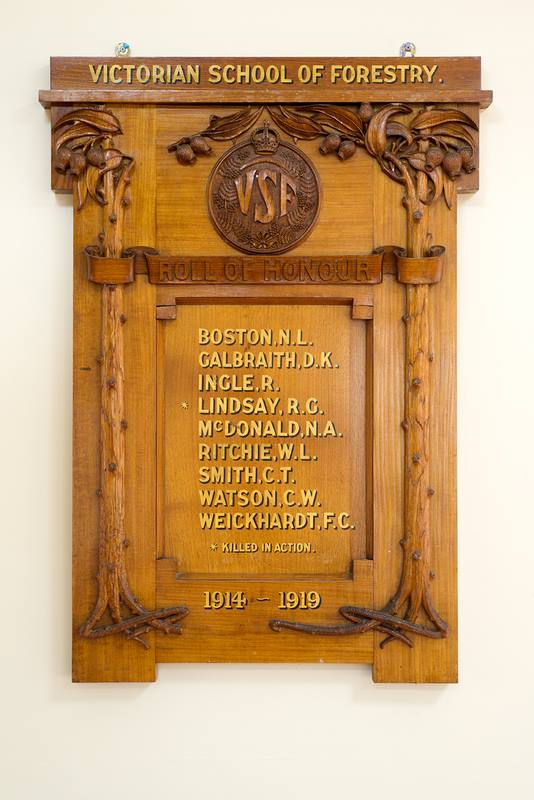
Over the next week or so I shall post short stories about some of the men from the State Forests Department* and the Victorian School of Forestry that served.
I can find some of their military records in the National Archives and the Australian War Memorial, but there are many things missing, as well as lots of anomalies in the official documents.
The names of the two honour boards don’t even line up.
For example, there is Ritchie W L is on the Forestry School honour board with Ritchie W S on the State Forests Department board, while his army records simply lists him as Ritchie W (with no second initial).
Then there is Galbraith D K and Weickhardt F C on the Forestry School board that dont appear to have worked for the department after the war.
Sometimes they don’t list their occupations as foresters on their enlistment papers. I think this was because forestry was a protected occupation.
But sadly, I can’t find much at all about some of them, or their stories, so I welcome any contributions to fill in the gaps.
* The Forests Commission Victoria (FCV) didn’t come into existence until after the war.
During the Great Depression of the 1930s, the Forests Commission ran a large unemployment program of firebreak slashing, building roads, erecting firetowers, silvicultural thinning, firewood cutting, weed spraying, soil erosion works and rabbit control. Importantly, most of the work was in country areas.
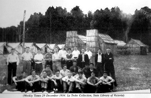
By 1935-36 almost 9000 men were employed for periods of up to eight weeks at a time. Their bush camps generally comprising 25 men with two-thirds being from the city. And despite the blisters, many remained in the country to make their future.
The Country Roads Board, State Rivers and Water Supply Commission and Melbourne Metropolitan Board of Works also employed large numbers of men known as a sussos, which was slang for sustenance workers.
However, there was a special need to provide opportunities for young people.
Newspapers warned of long-term consequences of enforced idleness of youth of the Nation, claiming that if nothing was done “many would become permanently unemployable and would settle down to a life on the dole or turn to crime”…
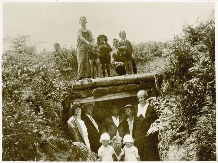
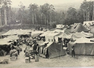
With the support of two prominent Melbourne businessmen and philanthropists, Herbert Robinson Brookes and George Richard Nicholas (of Aspro fame), together with Forests Commission Chairman, A. V. Galbraith and the Minister for Forests, Sir Albert Lind, a unique and enterprising “Boys Camp” was established at Noojee in 1933.
The Commission provided a timber hall and other facilities, but the boys camped in tents and there was initially no electricity. Commission officers also supervised thinning and ringbarking of young stands of messmate, silvertop and mountain ash together with fire protection works on the 2000 acres of private land purchased and donated by Brookes and Nicholas.
Groups of about 30 young boys, aged between 16 and 19, were at the camp at any one time and were paid at rates applicable to Forests Commission workers, but money was deducted for food, accommodation and medical support. And if they didn’t work… they didn’t get paid.
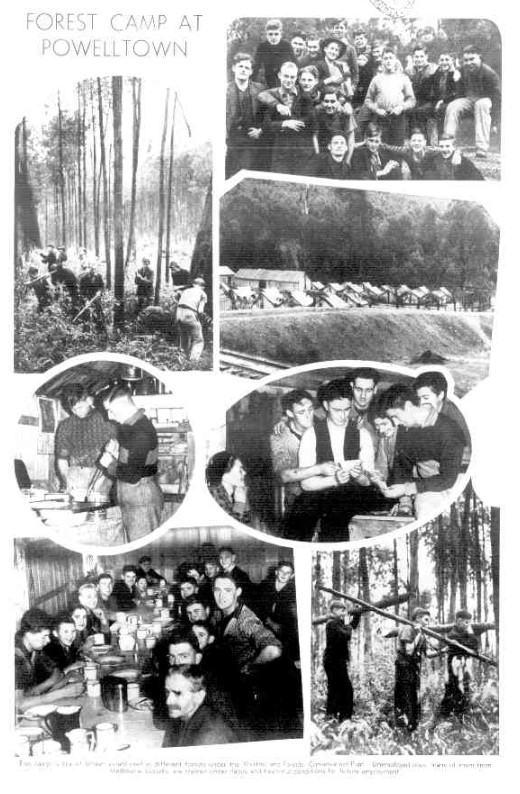
The idea was a success and extended across Victoria to another 15 sites including a second camp at Noojee.
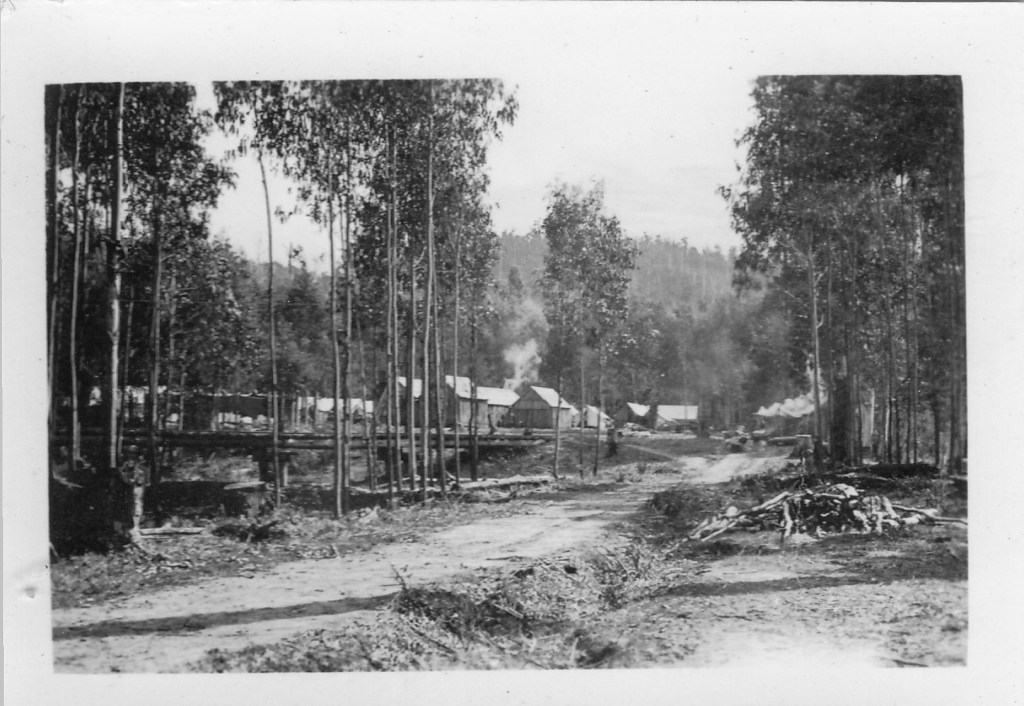
By June 1934, the Forests Commission ran Boys Camps at Noojee (X2), Bruthen, Bairnsdale, Powelltown, Acheron/Marysville, Gunbower Island, Otways, St Arnaud, Maryborough, Bendigo, Beechworth, Macedon, Daylesford and Ballarat.
Some 1276 boys had passed through the camps by 1936.
For many, it was their first experience of country life and Boys Camp proved one of the success stories of the 1930s and it was later reported two-thirds of the boys found employment.
With the outbreak of the War in September 1939, there was no longer a need for a youth unemployment program, but some of the camps were used by high school and university students to produce emergency firewood for Melbourne until 1942.
After the war, the Noojee camp was once again occupied as a temporary home for immigrants fleeing Europe. But all trace is now gone.
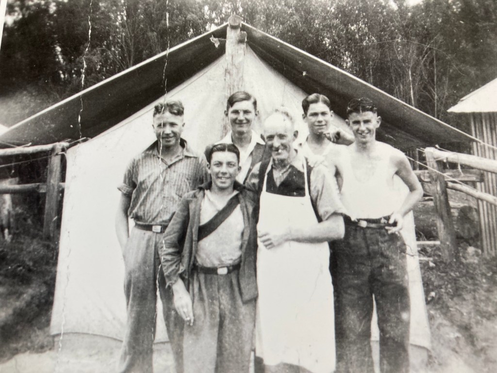
Richard (Dick) Mumford (in apron) was the popular cook at Noojee. He and his wife later lost everything in the 1939 bushfires. Photo supplied by his great-grandson, Wayne Mumford. Circa – 1936.Photograph taken in 1934 or 1935 (Source: R Graham via AL Benallack) : Noojee Boys Camp staff – R Mumford (Chief Cook), AL Benallack (Forester), D Williams (Foreman), F Noar ?? but caption on photo unclear, Asst cook, W Fisher (Senior Boy), B Fidler (Foreman)Groups of about 30 boys were at the camp at any one time. Source: Philippa Watt.The first batch of 30 “lads” departed by train from Flinders Street for the new Boys Camp at Noojee on 21 June 1933 but cold weather and winter rain in the wet forests hampered the camp’s establishment. Local community people supported the boys. Source: FCRPA collection.Photograph taken in 1934 or 1935 (Source: R Graham via AL Benallack) : Noojee Boys Camp – HeadquartersPhotograph taken in 1935 (Source: R Graham via AL Benallack) : Noojee Boys Camp – Source: – Ben Benallack FCRPA CollectionPhotograph taken in 1934 (Source: R Graham via AL Benallack) : Noojee Boys Camp – approaching from Noojee
Photograph probably taken in the mid to late 1930s at the FCV Olangolah Boys Camp (Source: Jim O’Dowd) : Back left – Tom O’Dowd (FCV Leading Hand & uncle of Jim). Front right – Wally Prosser (Camp cook & a grandfather of Jim)FCV Boys Camp at Olangola (Otways). Source: FCRPA Collection
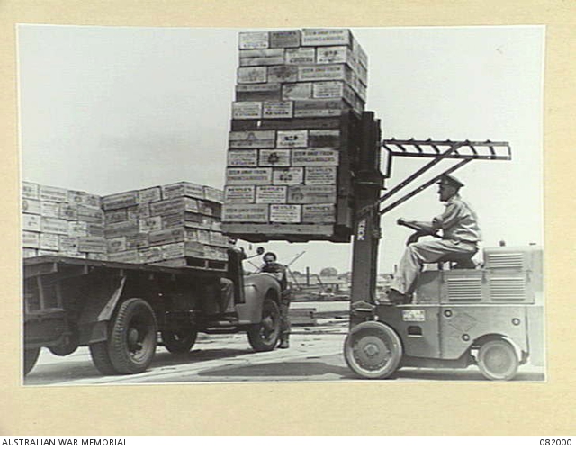
The humble timber pallet (or, less typically, a plastic or metal one) has at some time or another, probably carried almost every type of object in the world.
For a mostly unseen and unnoticed item, pallets are everywhere, and there are said to be billions of them circulating through the global supply chain.
While there is some debate about their pedigree, pallets as we now recognise them, were not around until the forklift arrived in about 1915.
Australia was one of the first countries to develop the standard timber pallet. During World War 2 the United States as part of their huge logistics effort to supply allied troops, used pallets for transport on a scale never seen before.
When the war ended in 1945, the Americans left behind their materials handling equipment and a very large stock of wooden pallets. The Australian government seized upon the opportunity during the hectic post war reconstruction period and formed the Commonwealth Handling Equipment Pool (CHEP). It was a game changer.
The Government sold the assets of CHEP in 1958 to Brambles, which is now the largest pallet rental business in the world.
But despite efforts for global standardisation from the 1950s, the Australian standard pallet is rarely found elsewhere. But its square size (1165 mm × 1165 mm) fits perfectly into a standard RACE container used by the railways.
In Victoria, the largest producer of CHEP timber pallets is Dormit which began operating in about 1989, and now has modern sawmills at Dandenong and Swifts Creek.
The company sources low grade hardwood logs from State forest and private land that would have otherwise only been suitable for pulpwood.
From a small allocation of about 80,000 tonnes, the Dormit has grown into Australia’s leading manufacturer of over 1.2 million pallets in 2021.
However, the long-term supply of pallet grade sawlogs from State forests is under a cloud.
The timber pallet is possibly the single most important and under recognised object in the global economy, other than maybe the shipping container.
John Klunder Jensen was born in Bendigo in 1884 but had to leave school at the age of 11 to find work following the early death of his father in 1895.
He moved to Melbourne in 1898 and in 1900 took a job as a junior messenger boy in the Defence Department’s ordnance stores branch at Victoria Barracks, which at a time was dispatching large quantities of ammunition and equipment to the South African Boer War.
A self-educated man, John eventually forged a highly successful career with the Department of Munitions, including during the critical war years.
A compulsive worker he presided from his office flanked by a ‘tin hat’, Bren-gun and portable typewriter.
Sir John Jensen was appointed OBE in 1938, and knighted in 1950, for his services to Australia.
John was also an active member of the Melbourne Walking Club from 1922 to 1938 and continued his interest in walking and the Australian bush until his death in 1970 at the age of 85.
He regularly went long treks lasting from several days, and up to a week at a time, which covered between 70 and 130 miles.
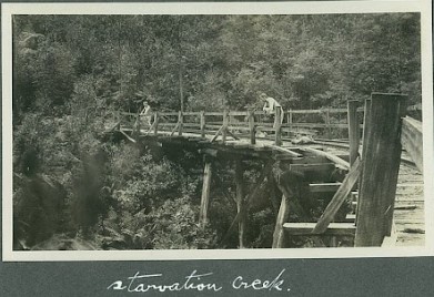
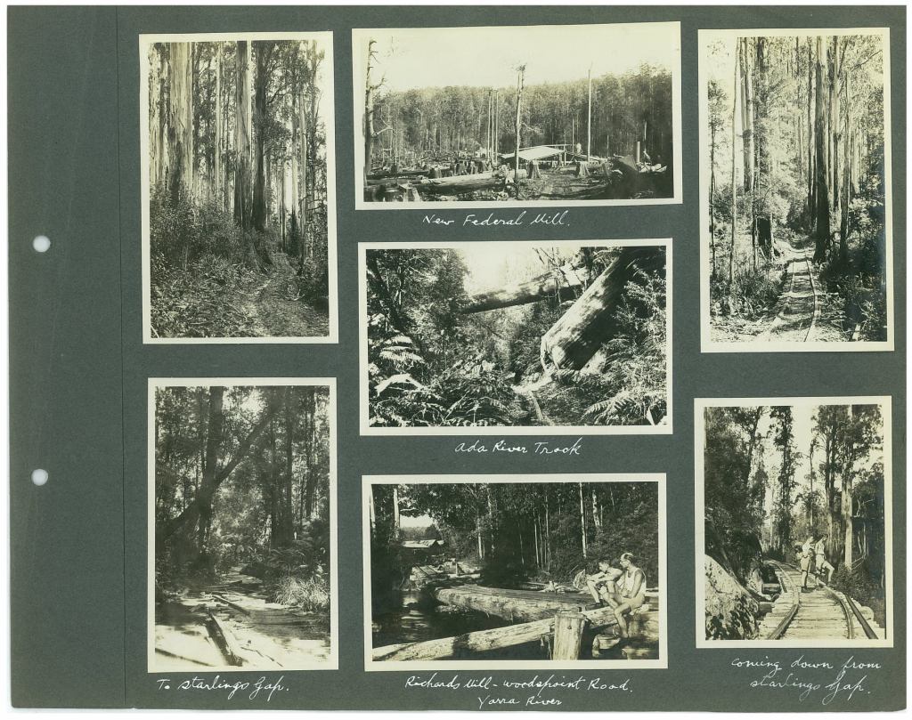
Luckily for us, John Jensen often carried a camera and tripod and fastidiously recorded his photographs in albums. But most significantly, his photos give us a glimpse into the forests before the devastating 1939 bushfires.
John Jensen sometimes contributed articles to “The Melbourne Walker” magazine and the club have generously placed his extensive collection bushwalking photo albums in the care of Royal Historical Society of Victoria.
Here is a just a sample from the Starvation Creek – Federal Mills Walk near Powelltown c 1922.
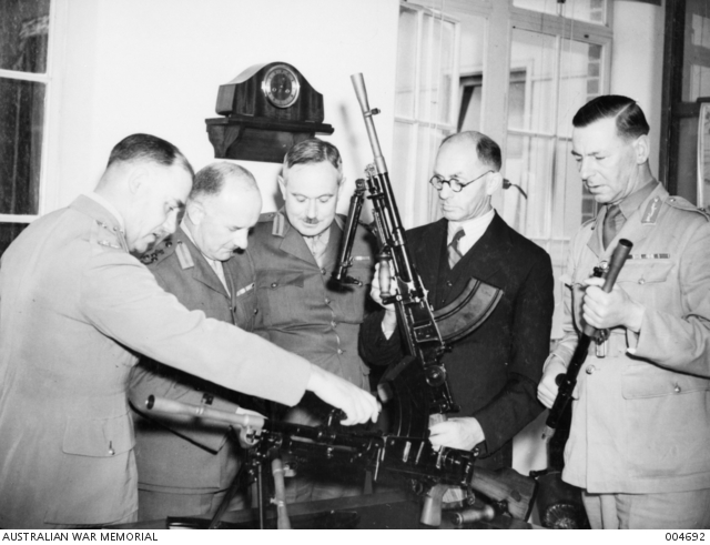
Victoria Barracks Melbourne – January 1940. The first bren gun made in Australia being inspected by (L-R) General Northcott, Brigadier Milford, Brigadier Combes, Mr John Jensen (controller general of munitions administration) and General Stantke. Source: AWM
Forty years ago, south eastern Australia was in the middle of a prolonged drought and facing a perilous bushfire season.
A new ebook provides a detailed account of the 1982-83 bushfire season from a Victorian forester’s perspective.
And while the bushfire season is best remembered for those on Ash Wednesday on 16 February 1983, where 47 people died In Victoria and a further 28 in South Australia, significant bushfires occurred right across Victoria from August 1982 until April 1983.
It was a long and hectic fire season for the Forests Commission Victoria (FCV) which attended 878 fires on State forests and National Parks totalling 486,030 ha, which was well above the 11-year average of 141,000 ha.
Over the 1982-83 fire season, 22 Total Fire Ban (TFB) days were declared. Close co-operation was maintained with the Victoria Police and Country Fire Authority (CFA) which attended nearly 3,200 fires during the summer fire danger period.
A large part of this document outlines the accumulated wisdom, achievements, planning and preparations undertaken by the Forests Commission (now DELWP / FFMVic) to build an effective firefighting organisation in the decades following the catastrophic 1939 bushfires leading up to the 1982-83 season.
Major campaign bushfires at Cann River together with a forensic analysis of the bushfire at Greendale on 8 January 1983 which killed two Forests Commission machine operators, Des Collins and Alan Lynch, is included.
The role of the Commission in major bushfires on Ash Wednesday is also described in some detail.
The aftermath of the bushfires is outlined as well as the major organisational changes introduced by the new Cain Labor State Government from mid-1983.
Sadly, very little can be easily found in old newspapers, in books, or on the internet about the significant role of the FCV.
This story of the 1982-83 fire season was assembled nearly 40 years after the momentous events using internet searches, newspaper accounts, coroner’s reports, FCV files held in the Public Record Office, witness statements, police reports, personal recollections and some limited interviews.
There remain significant gaps and sadly many of the key FCV staff are no longer alive or available to give their version of events.
My main hope is to tell some of the rich story of the Forests Commission during the 1982-83 fire season and place it on the public record in time for forthcoming 40th anniversary next year.
A free e-book has been lodged in the State and National libraries as an enduring record of the Forests Commission, and its staff’s, achievements.
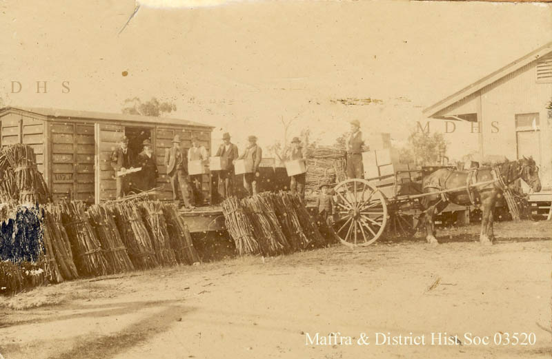
Harvesting of various wattle species began in Victoria and southern NSW around the time of the gold rush in the 1850s.
Black wattle (Acacia mearnsii) is a small, fast-growing, leguminous tree and was highly prized for tanning leather. The tannin is also used to produce waterproof adhesives in reconstituted wood products.
Bark was stripped from the wattles in spring and into summer when the sap began to flow which made it easier to remove. But harvesting killed the tree.
The bark was bundled and dried, then chopped and crushed by machine or by hand and mixed with water and other chemicals in deep pits to brew tannin liquor. Large hides, which had already had the hair removed by using a lime solution, were immersed in the pits until completely tanned. The hide was then stretched, dried and compressed by rolling between massive brass rollers.
Unsurprisingly, the left-over bark material was called “tanbark” and was often reused as a garden mulch or on pathways. The Tan, the 4 km path around the Royal Botanic Gardens in Melbourne, gets its name from its original wattle bark surface.
By the early 1800s, areas around Western Port and Portland were major centres for wattle bark stripping, but operations soon extended across Western Victoria and well into the southern estuaries of East Gippsland.
At Lakes Entrance bark was used to tan sails and season fishing nets to protect them from decay in the salt water.
The industry developed very rapidly and at one stage in 1868, there were 2000 tonnes of bark ready for shipment from Bairnsdale. During the period 1871 – 1884 nearly 20,000 tons of wattle bark was exported from Portland.
The establishment of tanneries at Sale, Stratford and Bairnsdale added to the demand and by 1875 wattle stripping had even extended to Orbost.
By 1882 a pound and a half of Black Wattle bark was said to make 1 lb of leather, and a ton of bark was considered sufficient to tan between 25- 30 bullock hides.
The strong demand for bark coincided with the selection of land for agriculture. Bark stripping not only helped farmers to clear their land but also provided much needed income.
State forest was also harvested by ex-miners and other itinerant workers. Bark stripping paid well but it was very arduous work.
Bakeries valued the left-over wattle branches, a by-product of bark stripping, because it produced a quick hot fire. The wattle timber also produced a very fine white ash, which could be blown out of the oven and the bread cooked in the residual heat.
Wattle was used as garden stakes.
But tanning required large quantities for fresh water and were always sited on waterways and usually close to towns. Tanneries had a reputation from being smelly and polluting waterways with effluent. Most of Melbourne’s tanneries were in the northern suburbs and along the Yarra.
But uncontrolled bark striping across the State forests nearly brought wattles to the edge of extinction.
The State Government’s concern about forest devastation and the potential impact on both the footwear and tanning industries led to the Wattle Bark Board of Inquiry in 1878.
The Inquiry had some distinguished figures including Joseph Bosisto, Member of Parliament and eucalyptus oil pioneer, and Baron Ferdinand von Mueller, the State Government botanist. The Board made many sweeping recommendations including licensing of wattle harvesting, seasonal restrictions and encouraging cultivation.
Attempts were made to grow wattle, with some degree of success. A Government financed plantation was planted in the Kentbruck area but was burnt out by a bushfire before it was harvested. Others were established at Majorca near Maryborough – 500 acres, Havelock – 300 acres, and the You Yangs – 1,080 acres
Forests Commission Annual Reports indicate an ongoing supply of tan bark from State forests at 1919/20 – 471 tons, 1929/30 – 614 tons, 1939/40 – 796 tons; 1949/50 – 424 tons and 1956/57 – 445 tons. Most harvesting had concluded by 1960 because of the increased availability of alternative chemical tanning agents.
Black Wattle is native to Australia but was introduced to South Africa in 1871 and now dominates what remains of the global market.
Report of the Wattle Bark Board of Inquiry – 1878.
Photograph probably taken late 1800s – early 1900s (Source: FCRPA) : Wattle bark stripped to be used to produce tannin.Stripping wattle bark, Meerlieu, 1925. Photo: MV – https://collections.museumsvictoria.com.au/items/769766Meerlieu, Victoria, circa 1925. https://collections.museumsvictoria.com.au/items/772828Three men with a wagon load of wattle bark. The load was 3 tons and was worth 11 pounds per ton. Balmoral District, Victoria, 1928. https://collections.museumsvictoria.com.au/items/769425Stripping wattle bark. Source: FCRPAWattle bark mill between Percy and Richmond Streets, Portland. Source: Vern McCallum Collection – FCRPABinding wattle bark, Bairnsdale district, 1923. Photo: https://collections.museumsvictoria.com.au/items/766941SLSA B15824, taken 1885 at Mount Gambier. “Bark mill and tannery in Edward Street, Mt. Gambier. “Source: Stawell Historical SocietySource: Vern McCallum Collection – FCRPA
In addition to building dams and water points, the Stretton Royal Commission recommended expanding the use of bushfire dugouts.
Well-constructed dugouts had saved the lives of many sawmill workers and their families during the 1939 bushfires. But in some locations, they had proved fatal.
Dugouts became mandatory for those few sawmills that remained in the forest after the 1939 fires. Many remote logging coupes and FCV roading camps also had dugouts.
The local District Forester was required to make annual pre-season inspections of all dugouts on State forests and those within the Fire Protected Area (FPA).
Some were built privately on private land.
Most were primitive construction with a log or corrugated iron roof covered with earth. A hessian bag often hung at the entrance to keep the heat and smoke out. But they were dark and damp with snakes and other creepy crawlies often lurking inside.
By 1940-41 there were 19 new dugouts constructed by the Commission and a further 128 by forest licensees. Ten years later there were 8 new Commission dugouts and 21 new ones built by other interests. By 1960-61 the rate of new builds was declining but the Commission still managed 103 dugouts while 127 were looked after by others.
However, as the forest road network improved and gave all-weather access to modern two-wheel-drive vehicles the reliance on dugouts receded.
In 1970 the Commission built a reinforced precast concrete dugout near Powelltown to house 30 people. But the number of dugouts maintained by the Commission had fallen to 61 with another 73 by others.
By the time of the 1982-83 bushfires there were 32 Commission dugouts and 18 others.
There are even still a few remaining in the bush.
The use of dugouts came into focus again after the 2009 Black Saturday Bushfires.
Dugouts were required at those sawmills that remained in the bush after 1939. Although there was pressure to relocate sawmills and associated small settlements to outside the forest estate. Photo: Rolly Park, District Forester at Powelltown – 1945. Photo: National Archives.After 1939. Source: FCRPAA private dugout at Gunyah in 1938. http://researchonline.federation.edu.au/vital/access/HandleResolver/1959.17/79830Dugout at Saxton’s Mill Tanjil Bren taken about 1939. George Jennings (L) and Reg Torbet (R). Source: Estate of G Jennings. FCRPA Collection
Wilfrid Russell Grimwade was born in 1879, knighted in 1950 and died in 1955. He led a remarkable and diverse life by any measure. He was a chemist, botanist, industrialist and philanthropist. He also had a passion for science, appreciation of art and sense of obligation to the community.
An early motoring enthusiast he was the first to drive from Melbourne to Adelaide
Russell studied chemistry at the University of Melbourne and in 1907 became a partner of his family’s multi-faceted and successful chemical firm.
Russell was also a keen botanist, especially of the eucalypts, and was official botanical adviser to the Army during World War II.
Before the War, he foresaw a shortage of certain essential drugs and in 1939 he cabled an English firm for a pound each of five drug seed varieties. Plants such a digitalis, heroin, hyoscine, opium, and other deadly, but lifesaving drugs were produced on his country home “Westerfield” near Baxter on the Mornington Peninsula.
While in his workshop he developed cabinet-making skills of a very high order using native timbers. In 1939 the workshop became a crutch factory, Russell and his friends producing 3000 pairs by 1941.
In 1920 he published “An Anthography of the Eucalypts”, which was illustrated with his own photographs.
He campaigned tirelessly for the conservation of forests as President of the Australian Forest League in 1922 and as a contributor to its journal the Gum Tree.
He supported the opening of the Australian Forestry School, at Canberra in 1927 under his friend Charles Lane Poole.
In 1929 he made an endowment of £5000 to the then Commonwealth Forestry and Timber Bureau to create the Russell Grimwade Prize for forestry. The award was for a post-graduate course at the Imperial Forestry Institute at Oxford, but this was subsequently amended to widen its scope. The funding was bolstered with a further £15,000 in 1954. Forest & Wood Products Australia (FWPA) now administers the prize which is awarded every three years.
Some notable Victorian recipients of the Grimwade Award include Alf Lawrence (1933), later Chairman of the Forests Commission, Bob Orr (1965), Senior lecturer at VSF, Arthur Webb (1968) Chief Forest Assessor, Peter Langley (1973), NRE Director of Regional Management and Dr Tony Bartlett (1984), now at the Australian National University.
As a gift to the people of Melbourne to celebrate the centenary of European settlement in Victoria in 1934 he donated Captain Cook’s cottage. The building was moved, brick by brick from Great Ayrton in England to the Fitzroy Gardens, shipped in 253 crates and 40 barrels complete with an ivy cutting which had grown on the original house. Today the cottage is covered by the ivy.
Prominent in such bodies as the National Museum, the Royal Botanic Gardens Melbourne, The Felton Bequest Committee, the Australian and New Zealand Association for the Advancement of Science and the University of Melbourne, Sir Russell Grimwade left a remarkable legacy.
Forest and bushfire management in the Colony of Victoria from 1851 through to Federation in 1901 can best be described as chaotic.
Prior to European settlement, nearly 90% of Victoria had been forested but it was rapidly, and indiscriminately, cleared by miners during the gold rush, by timber splitters and then in a mad scramble for land settlement.
At the time, the State’s forests were generally considered as the inexhaustible “Wastelands of the Crown”.
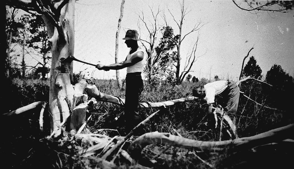
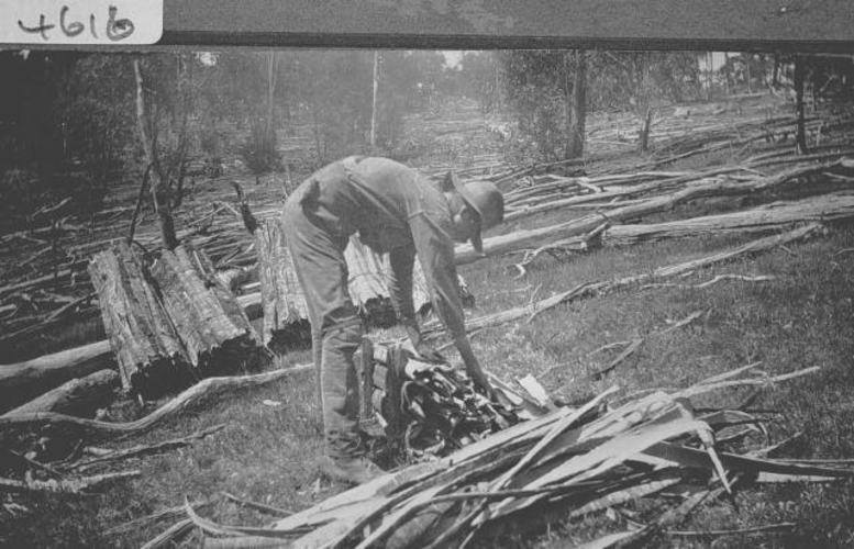
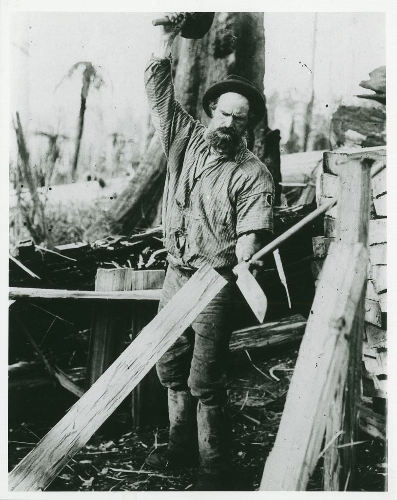
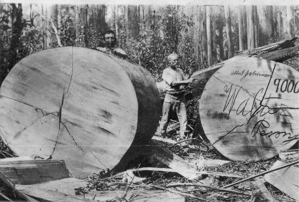
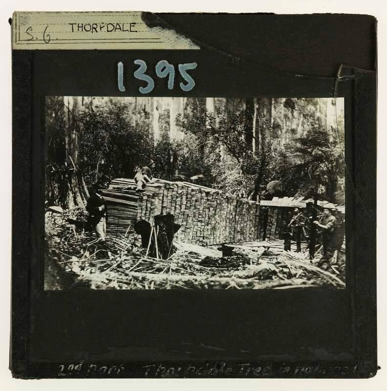
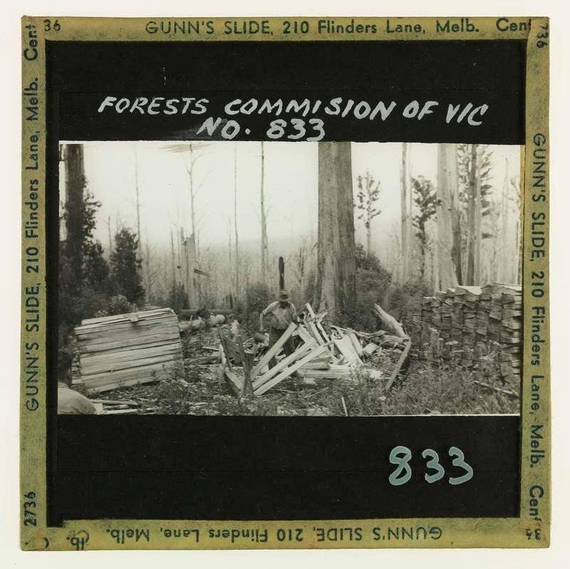
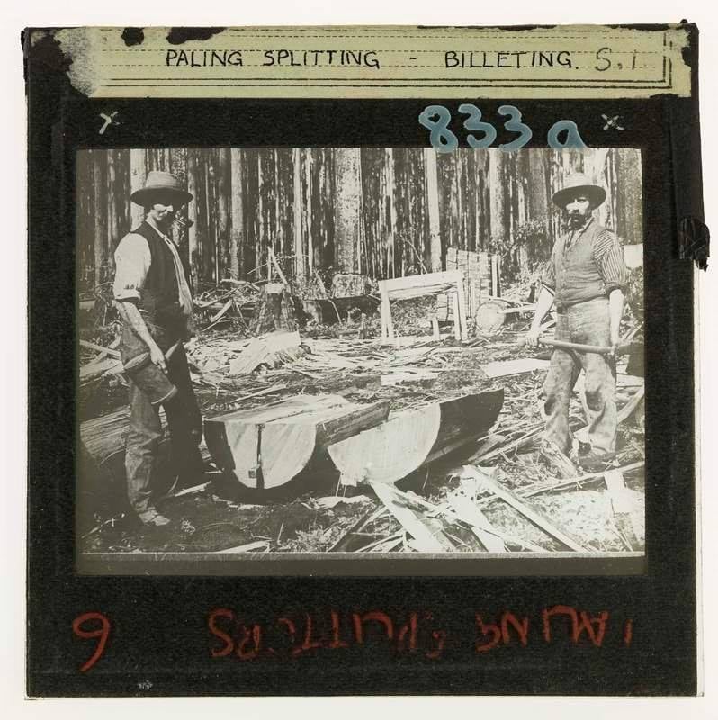
Timber splitters cut palings and other building materials and first operated around the gold fields in the 1850s to supply the mines and bustling townships. The splitters progressively moved east of Melbourne into the expansive wet forests from the 1860s.
Splitters camped in the bush and were attracted by the huge stands of mountain ash (Eucalyptus regnans), a tree that splits easily, and messmate (E. obliqua), which proved durable as a building material.
But by the late 1800s, most of the giant trees reported by the Government Botanist Baron von Mueller were being rapidly lost to timber splitters and land clearing.
There was little regulation and massive wastage of the forests and timber resources during the 1800s that could no longer be ignored.
However, the Government mostly responded with inquiries, inertia and inaction.
There were inquiries and independent reports from D’A. Vincent (1887) and then Perrin (1890) into the parlous state of Victoria’s state forests but with little result.
In 1895 the Commissioner of Crown Lands and Survey, Sir Robert Best, invited Inspector-General Berthold Ribbentrop, from the Imperial Forest Service in India to visit the new colony.
State forest conservancy and management are in an extraordinary backward state.
The forest laws of the country are inadequate.
The protection of forests against fires has never ever been attempted, and neglect and waste in their treatment are now as rampant.
The income from the forests is ridiculously small, and quite out of proportion to the large supplies drawn from them; and the money spent on their protection, maintenance and improvement is entirely inadequate.
His scathing report prompted a Royal Commission which commenced in 1897 and produced 14 separate reports before closing in 1901.
And despite spirited opposition by agricultural and grazing interests, the State Forest Department was finally created in 1907 with legislation formally setting aside timber reserves, regulating cutting and providing for rehabilitation after mining and logging.
Timber splitting eventually ceased but was replaced by steam powered sawmills and tramlines operating in the bush to cut palings and other sizes of building timber.
Splitters (1865). Plate 20 from The Australian Sketchbook by S. T. GILL. National Gallery of Victoria. https://www.ngv.vic.gov.au/explore/collection/work/29444/Wood Splitters 1886 – by Tom RobertsJohn Howard, from Thorpdale South, splitting paling. Gippsland & Regional Studies Collection. http://researchonline.federation.edu.au/…/1959.17/77671Paling splitters, Noojee area, circa early 1900s. Unknown photographer, but possibly J. Y. Woolstencroft. Source: Steve Johnson – Gippsland HistoryThorpdalePaling – splitting on Saxton’s Tanjil AreaWood-splitters hut near Lilydale, circa 1870-1890. Photographer unknown, part of the SLV’s Collection.Paling splitters, Noojee area, circa early 1900s. Unknown photographer, but possibly J. Y. Woolstencroft. Source: Steve Johnson – Gippsland HistoryPaling splitters. circa 1890-1900. The pile of palings is stacked into ‘books’. State Library. http://handle.slv.vic.gov.au/10381/82048Paling – splitting on Saxton’s Tanjil AreaFalling mountain ash at Mt Horsfall in 1928. Paling splitters were deep in the forest before there was any sawmill logging in the area. Note the chip taken out, above the cutter’s heads, to prove the tree suitable for palings. Source: FCRPA Collection.
Building fire dams was another of the many recommendations of the Stretton Royal Commission after the 1939 bushfires.
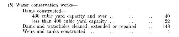
The Forests Commission annual reports give a clue to the increase in the numbers over the years.
There were no fire dams reported in 1939-40, but by the time that the Forests Commission ended and became Conservation, Forests and Lands (CFL) in 1982-83 there were 2169.
Building and maintaining fire dams was a local district responsibility. There was an engineer’s branch to help for bigger jobs.
But mostly the District Forester or overseer would simply identify a spot, usually near a road in a strategic location where there were no natural water sources, like rivers or creeks. Road drainage and table drains from the road were redirected into the dam to keep them filled.
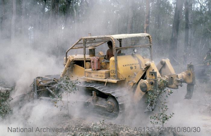
They were built and kept clean with departmental machinery and crews. The FCV had lots of heavy machinery as well as small district FADs to clean them out. Excavators weren’t around until the 1980s.
They were shaped with shallow entry and exits so FADs could keep them clean and so tankers could get closer.
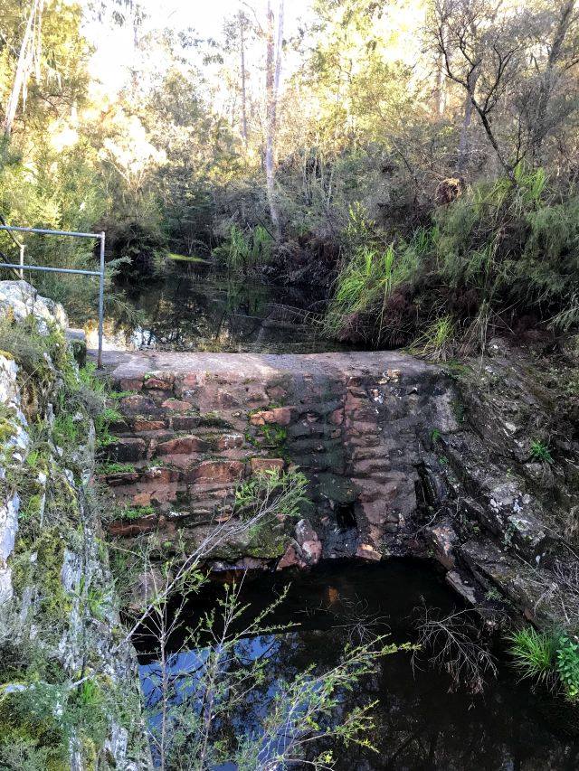
They weren’t all just simple holes in the ground either, some were proper stone weirs like Cosstick’s Weir in the Colquhoun forest near Nowa Nowa. There were bores and overhead tank stands as well.
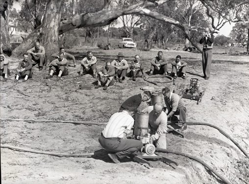
The dams were often used for annual pre-season pump schools where all the district staff would familiarise themselves with the pumps in the fire shed. Usually ending with an epic water fight.
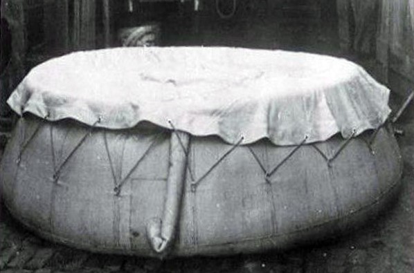
Well maintained roadside fire dam in the Colquhoun Forest. Photo: Peter McHugh 2022.Cosstick’s Weir in the Colquhoun was built in 1945. Photo: DELWPHundreds of fire dams were sunk in the bush. Source: FCRPA collection.Tank stand. FCRPA CollectionEarly version of a Slip-On-Unit. FCRPA CollectionPump School at Lake Glenmaggie. FCRPA CollectionPortable self rising water tank. Source: FCRPAFCV Annual report 1950-51FCV Annual report 1960-61FCV Annual report 1970-71FCV Annual report 1982-83
There is a common belief that even the slightest bushfire in mountain ash forests (E. regnans) is catastrophic and uniformly kills every tree in its wake.
It’s true that mountain ash is very susceptible to bushfire, but the story is not that simple.
Fire behaviour and intensity depends on many things, like forest type and age, fuel dryness, fuel load and arrangement, wind, topography, slope, aspect, RH, temperature, day or night.
Under extreme conditions bushfires will often “hill surf”, and spot fires may start many kilometres ahead of the main front.
These new spot fires on hill tops and ridges may join up, or they may inexplicably leave large unburnt gaps behind. They can also trickle slowly down slope against the wind and into the wet treefern gullies and then fizzle out.
At the other extreme, crown fires are created when the ground fires underneath build up sufficient momentum and elevated fuels like bark and scrub act as ladders allowing the fire to surge into the tree tops and the highly volatile eucalyptus oil to explode in fire balls.
However, the leaves on standing trees will not, on their own, support a fire, and fires will not occur in tree crowns unless there is an intense fire burning on the ground beneath.
Once the crown fire has surged ahead of itself and there is no longer a ground fire underneath it will collapse and sometimes swirl back on itself. This frightening phenomenon creates what I call “damage waves” that remain visible in the forest canopy long after the fire has passed.
Unlike other Ash Wednesday bushfires at Lorne or Trentham, the entire eastern flank wasn’t lost at Warburton with the south west wind change. Large sections of edge near Gladysdale didn’t travel, either due to damp forests or stands of mature wattle which had originated after the 1926 and 1939 bushfires. This was probably the main reason the fire split in two.
And all this “cross-talk” leaves a complex mosaic behind.
The final condition of burnt mountain ash forest may range from completely defoliated with 100% of the trees killed, or patches which have been only lightly burnt where the trees will survive, through to islands which are miraculously untouched.
It’s also not uncommon to find areas of mixed aged forest, where the fire has burnt lightly through the understory, and many of the older trees have survived, which allow patches of younger regrowth to develop in the gaps.
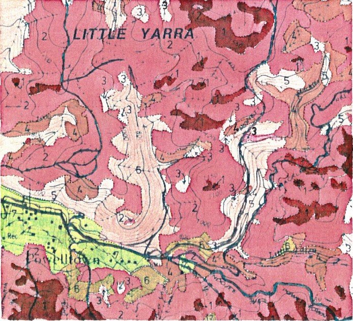
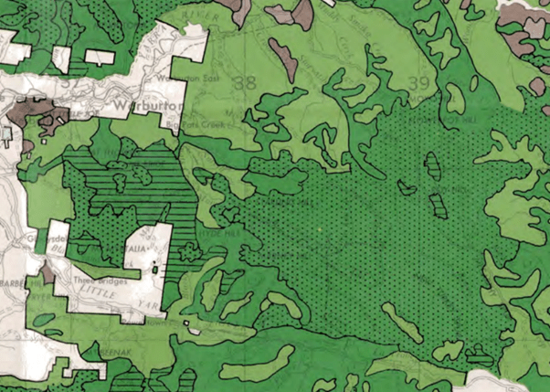
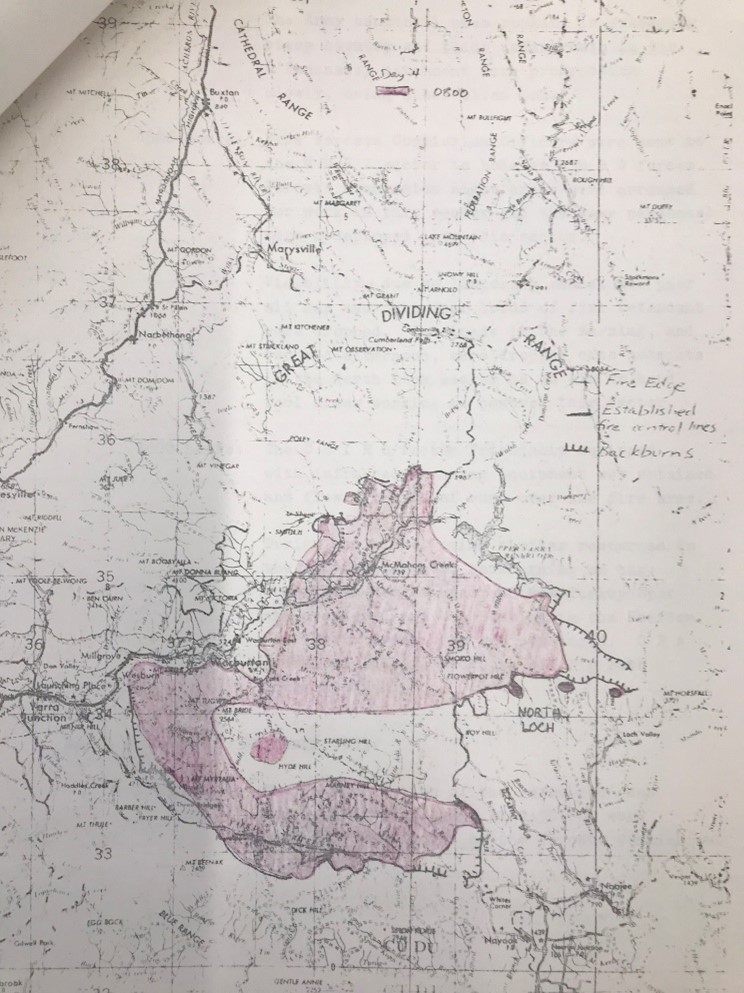
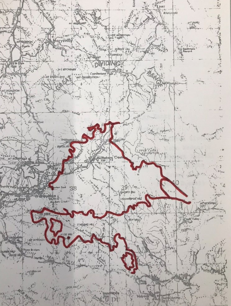
This aerial photo of damage class mapping after the 1983 Ash Wednesday fires at Powelltown illustrates what I mean.
Burnt 1939 Ash regrowth at Powelltown. Some areas have complete crown removal and others are severely scorched. From Woodgate (1984)Mountain Ash regrowth in the unburnt Ada BlockSeven fire severity classes are identified – Class 1 (100% crown removal) through to Class 7 unburnt.Linework transferred from aerial photo. Colours range from dark red is damage class 1 (100% crown removal) through to green near Powelltown township which is unburnt.Large stands of silver, black and hickory wattle (shown as horizontal hatching) can be found south of Warburton at Mt Tugwell and Cumming Spur. These forest types have a thick scrub understory and few eucalypts and often resulted from repeated bushfires in 1926 and 1939. They can also be less flammable than the surrounding messmate and mountain ash forest. In this case they helped split the Ash Wednesday fire on the south west wind change. 1971 Map from LCC. Source Rob Caddell.Extensive areas of mountain ash forest around Powelltown were killed by the 1983 Ash Wednesday bushfire. The forests had originated after the 1939 bushfires and regenerated naturally once again from seed fall. Photo: Peter McHugh 1983.Early stages of Day 1 before the wind change. Spot fire near Powelltown. Source: PROVWith the wind change at the end of Day 1 the fire split around Warburton and Powelltown. One part headed towards Reefton and the Upper Yarra Dam while the other headed east towards Noojee (dark blue line – Thursday day 2). Source: PROV
In July 1983, the Forests Commission ran a three-day staff workshop to review the previous calamitous bushfire season.
The formation of the Department of Conservation, Forests, and Lands (CFL) had only just been announced at the time of the meeting.
Police Commissioner Mick Miller’s Inquiry, and Coroner Anthony Ellis’s probe into Ash Wednesday were also underway.
Speakers at the FCV workshop addressed a wide range of issues and formulated actions on crew safety, management of resources, firefighting tactics, shift changes, equipment, skills training, communications, liaison with other agencies, logistics, use of aircraft for reconnaissance and firebombing, as well as weather and fire behaviour forecasting.
Included in the review was improving command and control at large bushfires.
Traditionally, District Foresters were responsible for any fire within the Fire Protected Area (FPA) and took overall control as “Fireboss”.
It was an entirely normal arrangement to have a FCV Fireboss in the field directing operations, for example, as at Greendale.
While it had advantages, the Fireboss role in the field had some serious shortcomings too, particularly if the fire escalated or became fast moving and complex.
The Forests Commission had begun experimenting with new fire control arrangements from the mid-1970s based on shared experiences with the US Forest Service. Different arrangements had been trialled at Cann River and Warburton.
But after the 1982-83 bushfires there were major changes in how the FCV approached large fire suppression and control on State forest and National Parks.
Whereas the CFA were responsible for fires on private land and operated independently on separate radio frequencies under a group structure.
Cross agency issues sometimes arose within the “Marginal Mile”; so FCV and CFA liaison officers were often appointed in the event of large or complex bushfires.
During 1984, Kevin Monk from the FCV’s Fire Protection Branch travelled on a Churchill Fellowship to California to study the United States National Incident Management System (NIMS).
Kevin brought back the NIMS documentation and developed a Victorian version, which became known as the Large Fire Organisation (LFO).
Importantly, the LFO was designed to be scalable; from Level 1 for simple local incidents, through to Level 3 for complex multi-agency and campaign bushfires.
By the summer of 1984-85 the LFO was being progressively adopted, with dedicated Incident Management Teams (IMTs) complete with Incident Controllers, Operations, Planning and Logistics units identified and trained within the new CFL Regions.
Under the new arrangements, the traditional role and title of FCV Fireboss at large bushfires all but disappeared.
Athol Hodgson was appointed CFL’s first Chief Fire Officer (1984-87) and was a strong advocate of the LFO. The fires of January 1985 in the alps near Mt Buffalo were the first major test for the newly formed department. It was also the largest deployment of firefighting aircraft in Australia up to that time, including 20 helicopters and 16 fixed-wing aircraft from the FCV, Australian Defence Force and NSCA. The LFO was given a thorough test run at these fires.
Later Chief Fire Officers, Barry Johnston (1987-90), Rod Incoll (1990-96) and Gary Morgan (1996-2005) maintained the momentum for changes to command-and-control arrangements at large bushfires.
Brian Potter, the Chief of the CFA (1985-91), also visited the US and became an enthusiastic supporter of NIMS, the LFO, and later, AIIMS.
Significantly, in 1986, the Emergency Management Act provided for a single controller to be appointed for each joint CFA/CFL bushfire.
Later in 1988 the Australian Association of Rural Fire Authorities adopted the principals embodied in LFO and NIMS.
AIIMS was jointly adopted by the CFA and CFL in 1991 with the intent of bringing emergency services together under one control system with common terminology, although it there was resistance to change within the CFA ranks and it took many years for some to make the full transition.
The operation and slow uptake of AIIMS was one of the key issues at the Coronial Inquest into the deaths of five CFA firefighters at Linton in December 1998.
The first international deployments in 2000 of Victorian firefighters to the US under reciprocal arrangements was made possible because of AIIMS.
Changes to AIIMS were introduced after the 2009 Black Saturday Bushfires.
Photo: The Large Fire Organisation (LFO) developed by the Department in 1984-85 became the forerunner of the Australasian Inter-Service Incident Management System (AIIMS) which was adopted nationally in the early 1990s. White tabard – Incident Controller, Yellow – Planning, Red – Operations, Blue- Logistics. Source: Peter McHugh, Traralgon ICC – 2013.
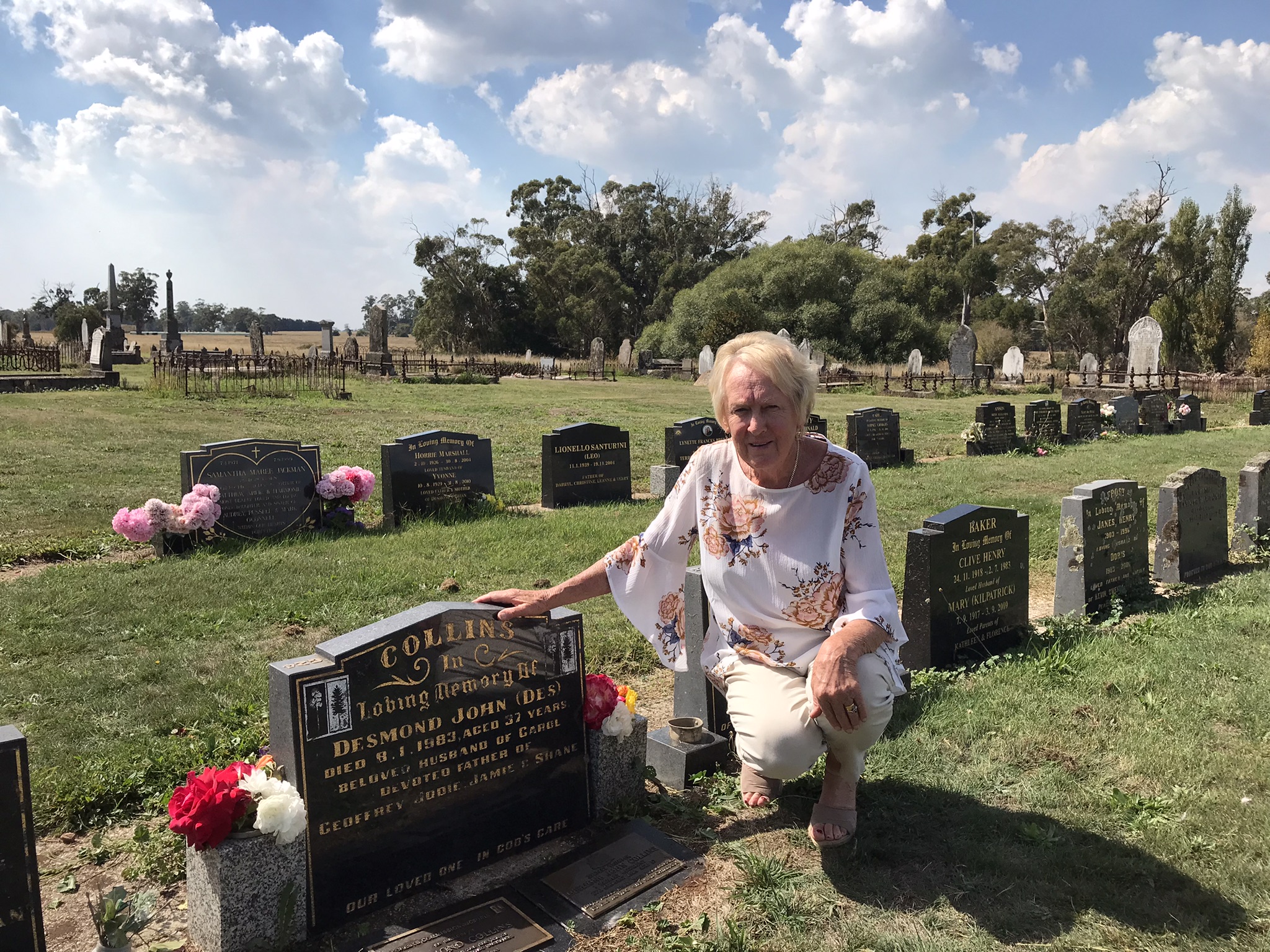
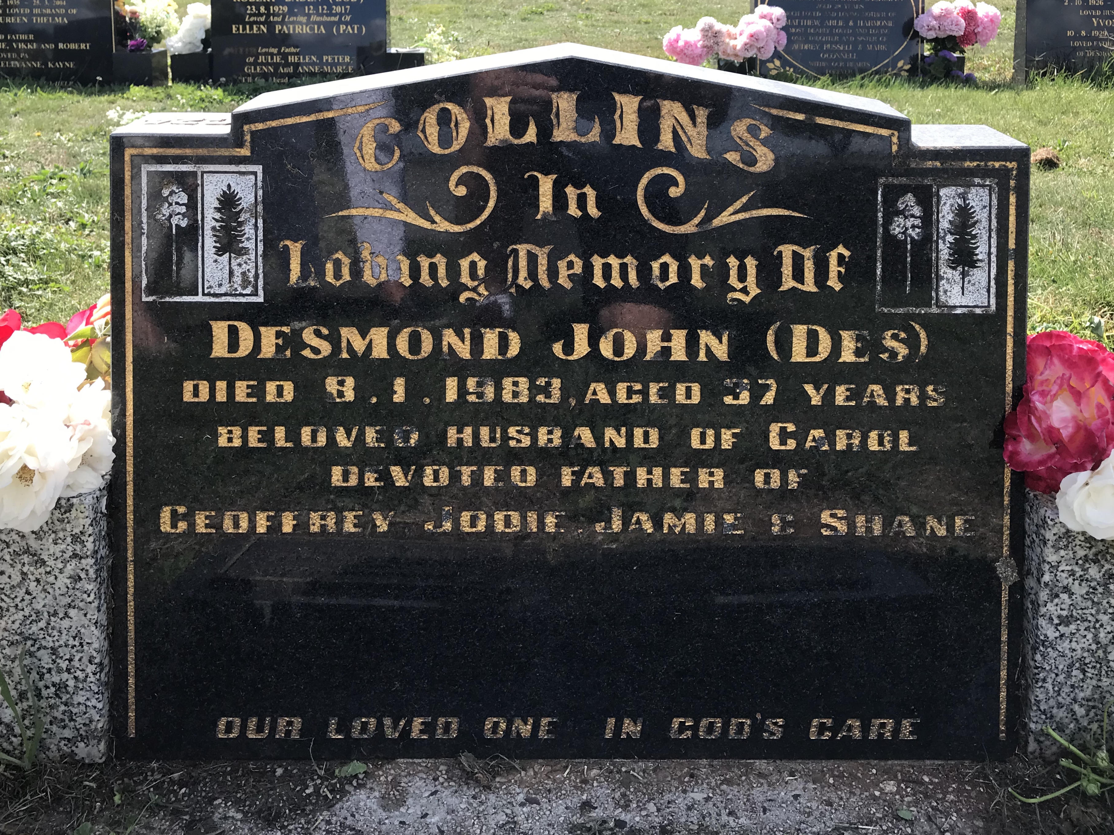
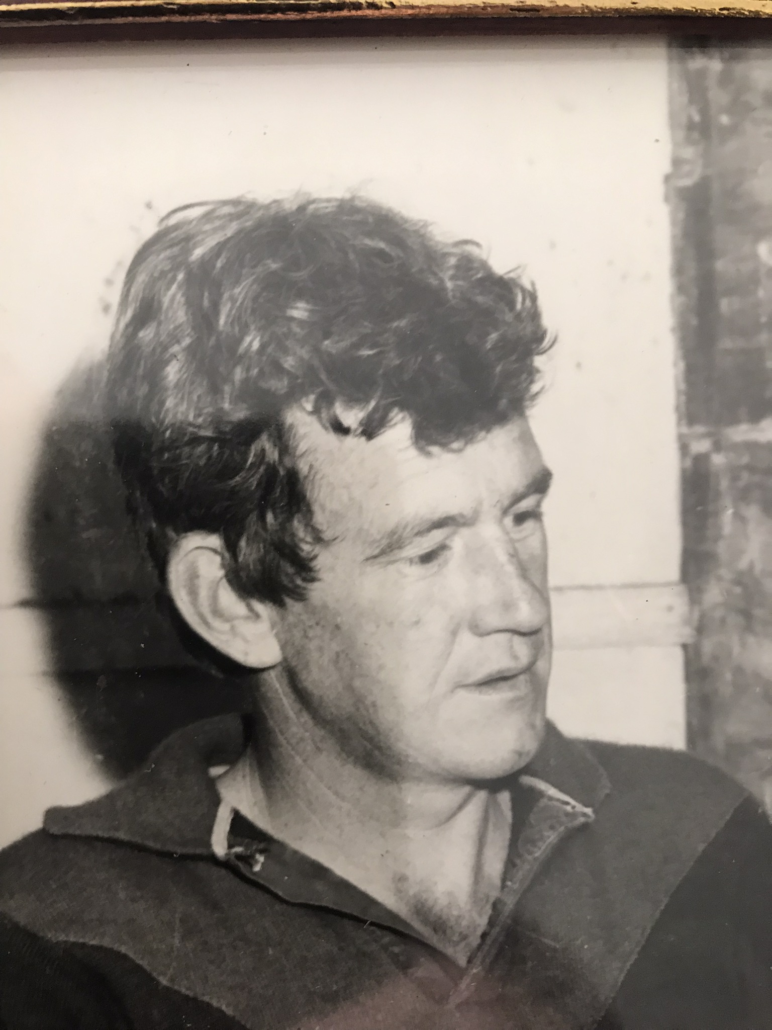
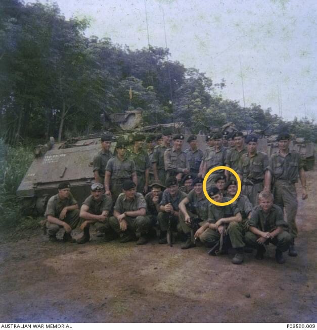
Desmond (Des) John Collins was born at Glenlyon on 12 June 1945 to Frank and Olive Collins.
The family moved to Daylesford in 1954 and Des left Tech School when he was 16 and took several jobs around the town.
Des had never really travelled far from Daylesford until he was conscripted into National Service in September 1965.
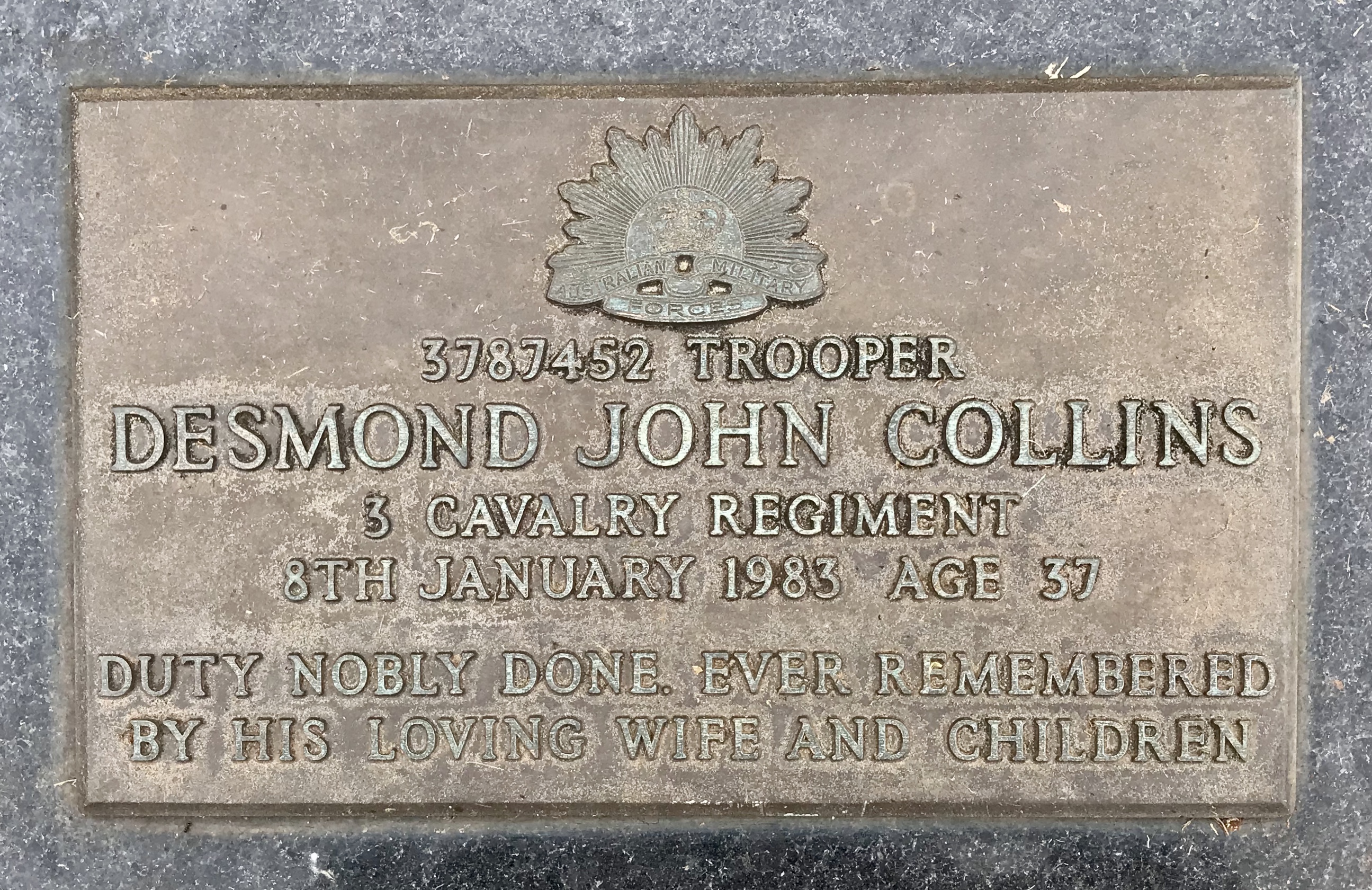
Sent to nearby Puckapunyal, Des completed his basic recruit training before being posted as Trooper (3787452) to the newly formed 1st Armoured Personnel Carrier Squadron (1 APC Sqn).
Des trained as a driver of an M113 Armoured Personnel Carrier (APC), and in May 1966 sailed on the HMAS Sydney to South Vietnam to join the 1st Australian Task Force at Nui Dat.
Upon its arrival, the first tasks for the APC squadron were to secure the new base by erecting defences and keeping the road between Vung Tau, on the coast, and Saigon open.
Because there were so few APCs at Nui Dat, the squadron was constantly busy supporting infantry, fire support, reconnaissance, cavalry roles, offensive manoeuvres against enemy positions, troop transport, moving equipment, towing artillery guns and casualty evacuation.
The squadron’s most notable battle was on 18 August 1966 to transport soldiers from A Company to relieve 108 soldiers of D Company holding out against overwhelming odds of about 2500 Vietcong, in the pouring rain, in a rubber plantation at Long Tan.
The day was supposed to be relaxing for the troops at Nui Dat with a concert by entertainers Little Pattie and Col Joye.
An artillery barrage began around mid-day on enemy positions 2.5 km away while RAAF helicopters flew over the beleaguered solders of D Company to resupply them with ammunition.
The rain became very heavy as Des Collins rumbled his APC out through the wire surrounding the base around 6 pm. It was a typical tropical downpour, but it muffled the noise of the engines and squeaking of the tracks which confused and surprised the Vietcong.
On arrival on the battlefield across the soggy rice paddies and flooded creeks, the APCs fanned out to make a sweep through enemy lines where they inflicted heavy casualties, before the Vietcong broke off and melted back into the jungle.
The battle ended and the monsoonal storm abated, as suddenly as both began. Under cover of darkness, the Australian units withdrew and regrouped while the dead and wounded were evacuated by helicopters. Soldiers spent a restless night as artillery and air strikes continued to pound the battle site and likely enemy withdrawal routes.
The next morning, a combined force of infantry and armoured personnel carriers went back into the battlefield to conduct a thorough clearance.
The Australians lost 18 men killed and 24 wounded. One of those killed was from 1st APC Sqn, and for their actions, three men from the squadron received gallantry awards.
After spending 12 months overseas in Vietnam, Des was honourably discharged in September 1967 and returned home to Daylesford.
In April 1969, Des married Carol Hill and the couple were blessed with four children – Geoffrey, Jodie, Jamie and Shane. They later built a new family home together in town.
Des remained an active member of the local football club, playing and then coaching juniors. He was also a member of the Daylesford RSL and CFA.
Around 1969, Des got a job on the crew with the Forests Commission at Daylesford, a job he loved.
One of his good friends was Alan Lynch, who also worked for the Commission on the crew, and they often walked to work together.
Both Alan and Des had many practical bush skills including roadbuilding, firefighting and driving heavy machinery.
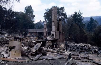
Tragically, both Des and Alan were killed in a bushfire at Greendale on Saturday 8 January 1983 when their machine was overrun by fire.
But their deaths were somewhat overshadowed by the major Ash Wednesday bushfires of 16 February 1983 only a few weeks later.
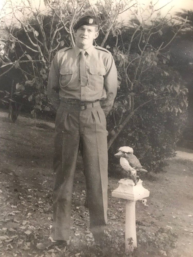
Trooper Collins at home before leaving for Vietnam in 1966. Source: Carol Collins
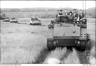
Troops of 6th Battalion, Royal Australian Regiment (6RAR) on Armoured Personnel Carriers of 1 APC squadron waiting to return to base at Nui Dat after the battle of Long Tan. 19 Aug 1966. Source: AWMThe drivers controls inside a M113 Armoured Personnel Carrier
3787452 Trooper Desmond John Collins, 1st Armoured Personnel Carrier Squadron (in beret, looking at camera) looks on as a member of 6RAR inspects a 57mm recoilless rifle captured during the Battle of Long Tan, on display at Dat Do. 19 August 1966. Source: AWM
1st Armoured Personnel Carrier Squadron about to depart Australia on the HMAS Sydney – 26 May 1966. Source: AWMLittle Pattie at Nui Dat – 18 August 1966. Source: AWMDaylesford cemetery. Photos: Peter McHugh 2022Des Collins. Source: Carol CollinsDaylesford CFA honour board. Source: Tim Fitzgerald
Group portrait of a mixture of 2, 3, and 4 Troop, 1st Armoured Personnel Squadron, en route to picking up 6 Battalion, Royal Australian Regiment (6 RAR), taken three weeks before the battle of Long Tan. Des Collins circled
Most focus and media commentary about the 1982-83 bushfire season naturally centres on the deadly Ash Wednesday fires of 16 February 1983 when 75 people were killed in Victoria and South Australia.
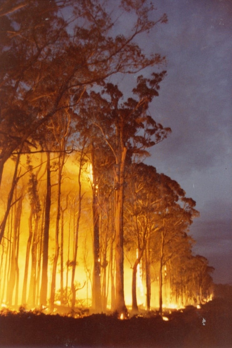
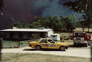
But in the far east of the State, and largely unreported by mainstream media, the Forests Commission Victoria (FCV) and CFA faced two large and adjoining campaign bushfires over a two-month period.
The two bushfires at Cann River were some of the largest in Gippsland since 1965.
Both fires burned under extreme drought and weather conditions, with temperatures exceeding 46 degrees, relative humidity as low as 16 %, and wind speeds exceeding 100 km/hr.
There was significant damage to productive State forest in Victoria. The Bondi plantations in southern NSW and National Parks were extensively burnt.
Losses to private property were comparatively small and included SEC power lines, Orbost Shire roads and timber bridges, several unoccupied houses and hundreds of kilometres of fencing. No lives were lost.
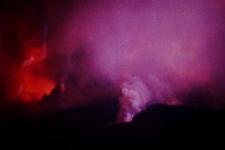
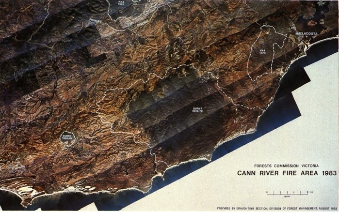
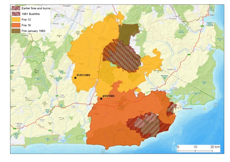
Cann River Fire # 12 – 127,200 ha
On January 31 a bushfire was detected in State forest north west of Noorinbee. The fire was believed to have started five days earlier after a lightning storm.
It burnt north of the Princess Highway and into NSW for the next four weeks or so until 26 February.
This bushfire was impacted by extreme weather on 8 February, the day of the Melbourne dust storm, as well as 16 February, Ash Wednesday.
The fire front split around the earlier 1980 fire at Coopracambra on the NSW border.
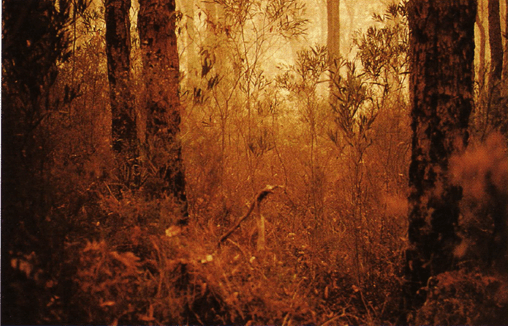
Cann River Fire # 16 – 126,100 ha
On 4 March, during extreme fire weather, a breakaway on the southern edge of the earlier fire #12 spread quickly towards Genoa, Tamboon and Mallacoota Inlets. It blocked the Princes Highway and burnt for another 3 weeks until 20 March.
It’s reported that a heroic effort to light a backburn and hold the line at Stoney Peak on 9 March, in the face of 100 km/hr winds, together with a previous fuel reduction burn in 1979-80 probably saved Genoa, Gipsy Point and Mallacoota.
Some observations from Denis Read the District Forester included:
Blow-up days occurred on regular weekly cycles (mostly Tuesday) while the periods in between were used effectively to build control lines, undertake backburning and consolidate boundaries.
Direct attack was successful during the night, usually in light fuels, and during the day if retardant was available. Although crown fires at night were also common.
Backburning was problematic in the very dry conditions and often failed, particularly if it was not possible develop a depth of burnt fuel between the fire edge and the control line.
Previous fuel reduction burning was effective in slowing the forward rate of spread of fire, even on extreme days.
Some earlier fuel reduction burning to west of Mallacoota in 1979-80 had a major benefit in saving the town.
Linking areas which had been recently fuel reduced, together with aggressive first attack and backburning to build containment lines were important and effective control strategies in the very dry conditions.
FCV tactics at the time were focused on direct attack and not on dropping back and building control lines well away from the fire edge.
Aerial flights were not possible on several occasions due to thick smoke caused by inversion layers or coastal sea breezes which blew the smoke back over the land.
Fixed wing agricultural firebombing aircraft operating from Mallacoota, Noorinbee and Marlo, with quick turnaround times, dropped nearly 400 loads of retardant. They proved very effective knocking down flames around houses and supporting ground crew to build control lines.
The MAFFS had some notable success, but the main problems were the lengthy turn-around times from RAAF East Sale together with accuracy and manoeuvrability in the mountains.
Small reconnaissance helicopters like Bell Jet Rangers were fitted with Forward Looking Infra-Red (FLIR) cameras to identify hot spots, or aerial incendiaries (ping pong ball) machines to assist with backburning.
A medium helicopter from the NSCA at Sale fitted with a bambi bucket did effective firebombing. Belly Tanks weren’t introduced until about 1984-85.
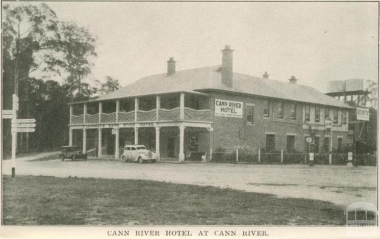
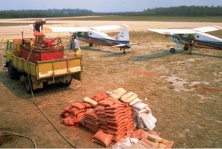
Photo: NAAPhoto: NAAPhoto: NAAA full range of services was on-hand at the Cann River Hotel.RAAF C-130 with MAFFS taken in 1983 at Cann River. Source: Bryan Rees. FCRPA Collection.DeHavilland Beavers at Mallacoota with an FCV designed portable retardant mixer- 1982-83. Source: Bryan Rees.Photograph taken in January 1983 near Cann River (Source: R Graham) : Spotfires near the front of the first major Cann River fire of the 1982/83 seasonNear Cann River near the head of the first fire of the 1982-83 season. Source: Bob GrahamNoorinbee Valley. Photo: Reg Armstrong.Noorinbee. Photo: Sue NeilsonAn area near Mallacoota which had not been fuel reduced has a thick understory and the trees have lots of flammable bark. Access and visibility also severely reduced. Source: Rawson et al (1985)An area west of Mallacoota which had been fuel reduced in 1979-80 helped save the township. Source: Rawson et al (1985)
A large area east of Wingan Inlet was burnt in 1978-79 and stopped the 1983 Cann River fire #16 although there is some overlap. Another area which had been fuel reduced in 1979-80 just to the west of Mallacoota township had the effect of slowing the run of fire and probably helped save the town. Imagery March 1983. Source: Rawson et al (1985).
Backburn on NSW border on a private Property boundary on Southern Access Road, maybe 18km north of the border, predawn on 9 February. 1983. The day after the Melbourne Dust Storm. Photo: Stephen Ledger. Source: South East timber association.The 1983 Fire #12 and Fire 16 as well as points of ignition are shown. Map: Owen Salkin. Note the shape the areas which were not burnt.in 1983: 1. 1978- 79 large fire east of Point Hicks (although there is some overlap on the edges). 2. 1980 Coopracambra fire on the NSW border. 3. 1979-80 Fuel Reduction Burn (FRB) west of Mallacoota which helped saved the township 4. The area marked in blue/green on the map on the NSW side was burnt by a deliberately lit fire in January 1983, not in the February fire. It stopped the eastern spread of the fire until the fire front was north of Imlay Road. A FRB done on in autumn 1980 along the length of Coolangubra Forest Way from Imlay Road to the Nalbaugh plantation then helped to contain the eastern flank. Two spot fires to the east of the White Rock River were contained for more than a day by an aerial ignition FRB in April 1981. Quick, Heather (1983). “When the bush burned – Cann River: The Big Fires”. ISBN 95 899 45 0 1. https://drive.google.com/file/d/1dPirCWwaYbrfjXUbR4fmTez_p9jMi2TR/view
Coopracambra fires – October 1980.
The shape of the first Cann River bushfire #12 was strongly influenced by a major bushfire on the NSW border at Coopracambra earlier in October 1980.
Dry conditions over the 1979-80 summer continued into the autumn and winter of 1980. Gale force winds hit across Victoria in late September.
Large bushfires broke out in East Gippsland during October, marking an early start to the fire season.
These fires also triggered the State Disaster Plan (DISPLAN) which remained in force for nine days.
Rain in late October eased the situation.
More large bushfires occurred again during December and January in the northwest of the State in the Sunset Country and Big Desert.
Maybe it was an ominous foreboding of a long fire season ahead for the CFA and the Forests Commission Victoria (FCV).
Major bushfires broke out in November 1982 at Seaton, Murrindal and Mt Elizabeth in Gippsland, as well as the mallee desert and Mt. Disappointment near Broadford
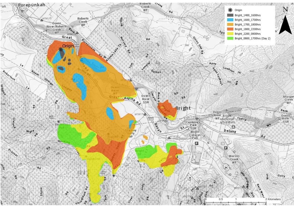
On Wednesday 24 November at 2.00 pm a fire started in the Two-Mile Creek plantation south of Porepunkah.
Bright fire #5 originated in some slash from a clear-felling operation in a stand of 1931 Pinus radiata. It was thought to have ignited by a spark from a chainsaw.
Derrick Rolland was the District Forester at Bright.
At 4.00 pm the wind strengthened, and the fire increased rapidly in size and burnt both sides of the Ovens Valley highway and was heading towards Bright. Houses were threatened in many places.
The most significant feature of this particular fire was the long-distance spotting of up to 1.8 km in pine plantations.
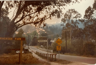
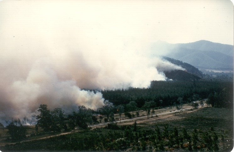
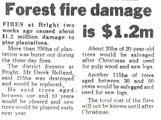
The 675-ha fire was contained later the next day. Over two days it burnt through native forest, private land and caused about $1.2 million worth of damage to 350 ha of FCV pine plantations.
The old Forests Commission plantation and nursery on the back Porepunkah Road was burnt too.
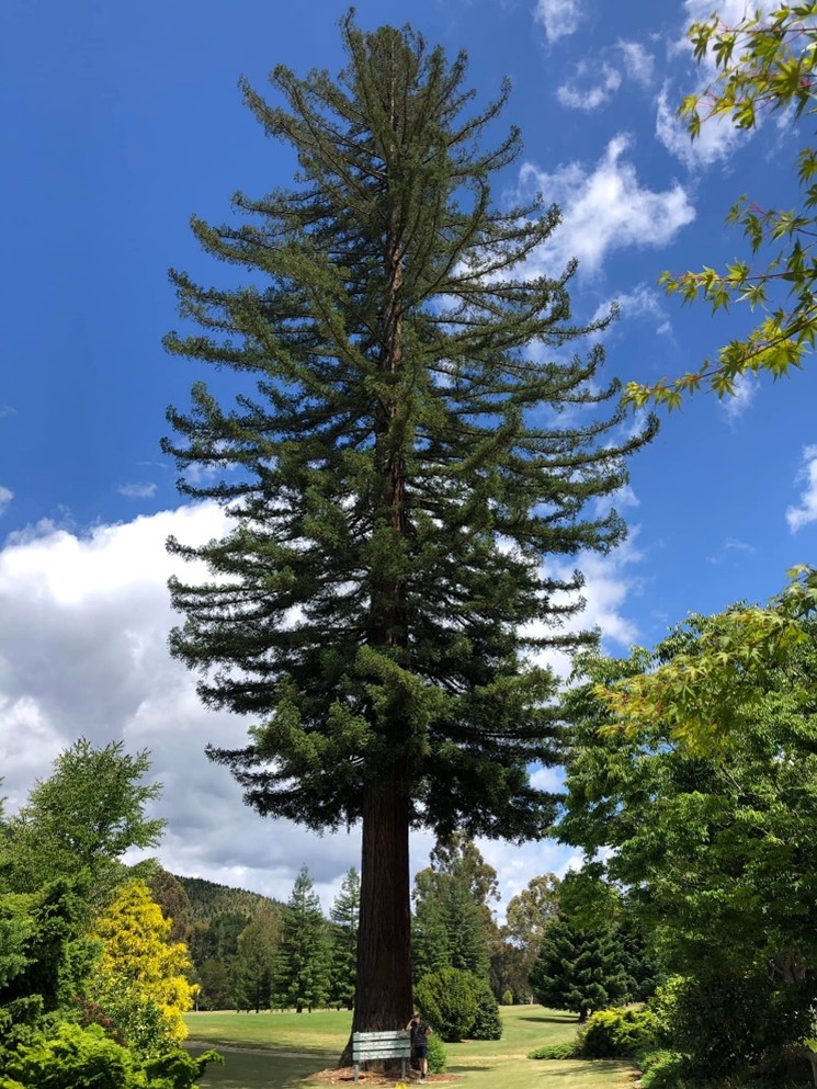
The nursery had been established at the turn of last century to raise pine seedlings to repair the damage left after gold mining along the Ovens Valley.
A large Californian Redwood, planted by the Commission in 1923, is all that remains after the fire and the site being converted into a golf course. The tree is listed by the National Trust of regional significance.
This 1982 Bright plantation fire is often confused with major bushfires at Bright and Mt Buffalo two years later on 14 January 1985 when 111 lighting strikes in 24 hours caused widespread fires across the alpine region.
The 1985 fires were the first major test for the newly formed Department of Conservation, Forests and Lands (CFL). It was also the largest deployment of firefighting aircraft in Australia up to that time, including 20 helicopters and 16 fixed-wing aircraft from the FCV, Australian Defence Force and NSCA.
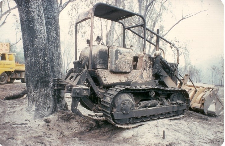
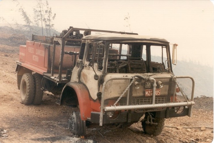
Back Porepunkah Road. Photo: Gary MorganThe fire threatened houses. Source: Rod IncollSource: Rod IncollPhoto: Gary MorganDestroyed small private dozer. Photo: Gary MorganPhoto: Lindsay BennettA bushfire warning sign to campers. Oh, the irony. Photo: Steve Jones.Photo: Gary MorganBright planation fire just north of the town – 24 November 1982 Photo: Jack Masciorini via Caroline DunlopA FCV tanker was lost during the fire when the fuel lines vaporised and it refused to start. Nobody was hurt. This was a common Bedford design fault. Some jokingly said this quirk was an inbuilt safety feature to stop crews getting too close to the fire in the first place. The tankers were later retrofitted with heat resistant lagging on the fuel and brake lines Photo: Lindsay Bennett.Source: Rod IncollSource: Rod IncollBorder Mail. December 10, 1982.Photo: Peter McHughA large Californian Redwood, planted by the Commission in 1923, is all that remains after fire and the site being converted into a golf course. The tree is listed by the National Trust of regional significance.Progression of the Bright plantation fire – November 1982. Map produced by Owen Salkin 2022. Based on FCV Fire Research Report No. 19 (1983). Neil Watson, Gary Morgan and Derrick Rolland.
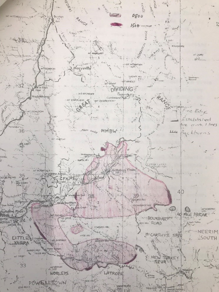
The Upper Yarra Fire #12 erupted on Ash Wednesday, 16 February 1983, on the slopes of Mount Little Joe near Millgrove at 7.20 pm and quickly progressed under the influence of the strong north westerly wind.
Also often known as the Warburton or Powelltown Fire, it was first spotted by Jon Gwilt in the Briarty’s Hill firetower, and while the cause is unknown, most suspected arson. Another fire broke out in virtually the same spot in 1991.
Purely by chance, the Forests Commission Victoria (FCV), the Melbourne and Metropolitan Board of Works (MMBW), and the CFA were marshalling some tankers and equipment at Yarra Junction with the intention of heading to Belgrave South and Upper Beaconsfield when the Warburton fire broke out.
The Cockatoo fire also broke out at 7.28 pm.
By 7.50 pm the fire had grown to 100 ha and reached the summit of Mt. Little Joe. About an hour later at 8.40 pm, the fire had begun spotting through thick forest into the small sawmilling township of Powelltown, 14 km away.
Direct attack on the fire was too dangerous and ineffective, so crews were dispatched to warn landowners of the advancing blaze and to protect lives and property.
By 8.00 pm the FCV resources totalled 28 men, 2 tankers, 1 dozer and 3 Slip-On-Units. About 80 CFA volunteers on 20 trucks were also deployed.
Ray Baker, the District Forester from Powelltown, was the Fireboss. Paul Mainey was the assistant forester and had been despatched to Trentham earlier in the day but returned on Thursday evening after being ordered by Ken Harrop, the Divisional Forester at Healesville. Forester Ron Harper assisted Ray during the initial run of fire.
The fire began spotting over the Old Warburton Road and calls were made for additional resources, but they were hard to find, with just about everyone and everything from the Forests Commission already deployed to other fires. Crews from Noojee that were on their way to Cockatoo were snaffled.
A little while later at 8.25 pm Briarty’s Hill reported the fire spotting over Britannia Creek Road, some 6 or 7 km from the origin of the fire.
By 8.40 pm the fire had spotted south of the Powelltown – Yarra Junction Road. This spot fire was to the west of the town and burning fiercely through thick messmate (E. obliqua) and silvertop (E. sieberi) forest with a very flammable wiregrass understory.
The hot wind was still from the northwest, but the change was imminent, when the main ground fire reached Podolinsky Hill near the township. The average Rate of Spread through the bush was 10.5 km/hr.
The southwest wind change arrived at 9.15 pm and split the fire in two. The northern front headed around Warburton township towards Reefton and the Upper Yarra reservoir, while the other near Powelltown moved back into the thick bush and headed towards Noojee.
And on the wind change, the small spot fire west of Powelltown burnt into a cleared area next to the FCV depot, nursery and office complex which was luckily spared.
Approximately 200 people took shelter at the local oval at Powelltown and at the town dugout. Residents from Reefton and McMahons Creek sheltered in a MMBW underground pipeline tunnel.
The fire continued throughout the night in the thick stands of mountain ash and messmate within the State forest. Because there was no threat to communities there was little point in mounting a suppression effort in the dark.
By midnight, the temperature was slowly dropping to 24 degrees with the RH hovering at 40%.
At about 04.00 am on Thursday a light drizzle began to fall at Powelltown as the temperature dropped even lower to 12 degrees. The rate of spread of the fire virtually stopped but it hadn’t gone out.
In the back of the fire controller’s minds was the blaze to the west of Powelltown near Kurth Kiln at Gembrook which had originated as a long-distance spot from Cockatoo. It was uncertain if more spot fires were still smouldering and undiscovered in the bush.
A reconnaissance flight was arranged at first light on Thursday with Assistant Divisional Forester Harry Prewitt to assess the situation and the damage.
By dawn at Powelltown there were 93 FCV employees plus 9 from APM with 8 bulldozers assembled to trail the southern edge and commence backburning. A further 30 FCV crew from Neerim south were deployed to the New Turkey Spur on the boundary of the two FCV Districts.
The Noojee township, which had been devasted by the 1939 bushfires, was evacuated and Police closed the Powelltown – Noojee Road.
Firebombers operated from Jessop airstrip near Noojee. The MAFFS was used to drop retardant on the main edge burning at the head of Alderman’s creek. Kevin Ritchie from Bendigo was the Air Attack Supervisor (AAS).
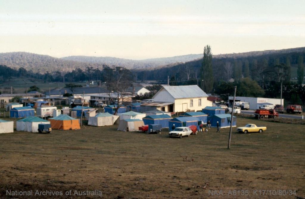
Basecamps were established at the Powelltown football ground, as well as the recreation reserve at Neerim South, with the support of the SES and Red Cross.
The northern tongue of the fire came out of the bush early on Thursday morning at 10.30 am when it crossed the Warburton Highway near the intersection of Brahams Road. Fortunately, the iconic stand of coast redwoods near Cement Creek, and the century-old Reefton Pub were spared.
The CFA had 60 units and 600 volunteers working at Wesburn, Reefton, Warburton and Gladysdale. The Metropolitan Fire Brigade (MFB) also sent appliances and crews from Melbourne to Warburton where there was a mains town water supply and were very effective.
On day 2, Thursday 17 February, the weather was mild with 22 degrees, RH 46% and a light south east wind of 10 km/hr.
Rod Incoll, the District Forester from nearby Toolangi was appointed night shift Fireboss while John McDonald from Alexandra and Andy Banks from Benalla, who had only recently transferred from Powelltown, took subsequent day shifts. Andy Beveridge worked at Neerim South.
The Navy sent 120 personnel from HMAS Cerberus, equipped with 110 fire beaters, 10 knapsacks and a mobile cooker to Powelltown on Friday to assist with fireline construction on Black Sands Road.
An Army crew, along with the FCV Mobile Support Crew (AKA Hotshots), worked in the O’Shannassy catchment alongside the MMBW to build a huge hand trail through the thick scrub.
There was a great deal of discussion about how to treat large patches of unburnt forest in the middle of the fire. Building a control line around the fire perimeter through the thick bush required a huge effort and may not be completed before the onset of more hot weather.
The CSIRO infrared Linescan was used on Saturday to map the fire boundary through the thick smoke. This is believed to be the first time the technology had been used operationally, and the image helped to develop a control strategy.
By Monday 21 February, the fire edge had stabilised, and backburning and aerial ignition was virtually completed in the expectation of more warm weather. However, 19 mm of heavy rain fell on Wednesday which extinguished most of the smouldering edge and made any further ignition impossible.
The rain enabled a major de-escalation of crews back to their home bases. The fires at Cann River were still burning and FCV crews were becoming exhausted with the repeated tours of duty.
However, the intense thunderstorm also caused major erosion of catchment slopes and gullies across the State forest. The rain which fell on Mt Little Joe created a mudslide of trees, rocks and debris to flow down a natural gully and completely block the highway to Warburton.
The fire also burnt the Yarra Tributaries and part of the Upper Yarra catchment which supply Melbourne’s drinking water.
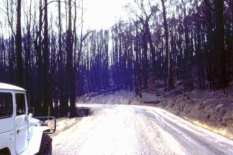
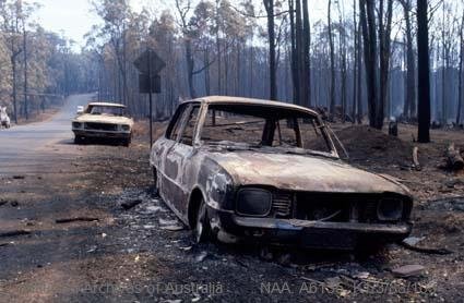
Overall, 27 homes were destroyed in the Warburton Fire #12, but no lives were lost so there was no coronial inquiry.
The Warburton fire was one of the largest on Ash Wednesday with an area of 44,500 ha. It killed or severely damaged 4,979 ha of mountain ash forest while a further 12,636 ha were less severely impacted or unburnt.
Salvage of valuable timber commenced almost immediately before the logs dried out and degraded. Fortunately, the experience gained by the FCV in the salvage after 1939 was put to good use in a program that followed the fires at Warburton, Powelltown Bruthen, Broadford and Cann River. Softwood salvage included operations at Bright, Macedon and Geelong.
By the end of June 1983 some 16,600 cubic metres of sawlogs and pulpwood had been salvaged while over the next 12 months this increased to 443,000 cubic metres of sawlog and 239,000 cubic metres of pulpwood.
And while it was not on the same scale as the massive 1939 salvage program, it took over two years to complete the salvage with logging contractors coming from adjoining forest districts.
Fire on Mt. Little Joe on 16 February. Source: CFAView from the main street in Warburton. Source: CFACFA Tankers at the century-old Reefton Hotel. Fires burnt all around the hotel with houses being lost close by. Photo Tony Crivelli.MFB Mk 2 pumpers were very effective around Warburton township where there was a MMBW mains water supply. Source: Fire Services MuseumThe FCV Mobile Support Crew (hotshots) worked with the Army and MMBW to build a massive hand trail through the O’Shannassy catchment. Note flannel shirts and jeans. No work overalls were issued, only hart hats and safety boots. Photo: Athol Hodgson.Extensive areas of mountain ash forest around Powelltown were killed by the 1983 Ash Wednesday bushfire. The forests had originated after the 1939 bushfires and regenerated naturally once again from seed fall. Photo: Peter McHugh 1983A healthy stand of mountain ash regrowth at Powelltown that regenerated following timber salvage and natural seed fall after 1983 Ash Wednesday bushfires…. Photo: Peter McHugh 2021.As many as 83 residents from the townships of McMahons Creek and Reefton sheltered in the underground MMBW tunnel at Upper Yarra Dam. Source: The Age
Early stages of Day 1 before the wind change. Spot fire near Powelltown. Source: PROVWith the wind change at the end of Day 1 the fire split around Warburton and Powelltown. One part headed towards Reefton and the Upper Yarra Dam while the other headed east towards Noojee (dark blue line – Thursday day 2). Source: PROVFriday Day 3 – Each of the tongues of fire expanded over the next 24 hours. Source: PROVSaturday Day 4 – The boundary became more stable. Source: PROVSaturday Day 4 – CSIRO LINESCAN was used to map the fire edge through the thick smoke. Source: PROVDetailed mapping of fires was greatly assisted using a CSIRO Fokker Friendship aircraft fitted with infra-red linescan equipment. FCRPA Collection.Backburning and aerial ignition was used to consolidate boundaries after the LINSCAN identified to large unburnt patches. Source: PROVMonday Day 6 – Final fire area.44.500 ha. Source: PROV
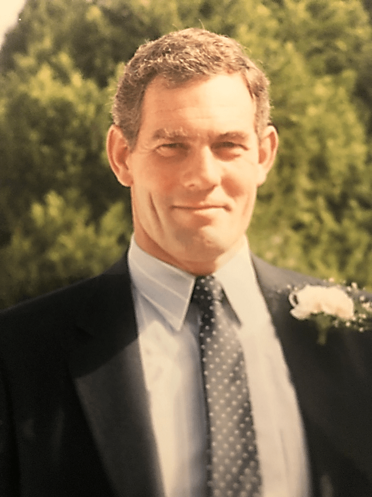
Don to many, and Thommo to just about everyone else, Don Thomson was a timber man, and a legendary forester’s forester.
Thommo was born in Lilydale on 25 March 1942 and his earliest years were spent with his grandmother on a poultry farm in Bayswater, while his father Norm served in the RAAF.
When Norm returned from the war in 1946 the family returned to Lilydale for a while, but Norm worked for the National Bank, first as a bank clerk and later as Branch Manager, and they moved to Terang in about 1951.
It’s often said Don had sawdust in his veins. His grandfather Bill Thomson was the skipper of the Paddle Steamer Adelaide from 1890 to 1912 which hauled red gum logs on the Murray River. He later became foreman of several sawmills at Echuca and Moama.
Don was a keen scout as a lad and enjoyed time in the bush where he always felt comfortable.
But in the late 1950s Don became increasingly disenchanted with the prospect of staying in the district and looked wider for an interesting outdoors job. Options included the defence force, surveying, agricultural science and forestry.
Forestry appealed, not only because it was outdoors, but it also offered a whiff of adventure. Besides, full scholarships were offered, plus the additional princely allowance of £2 per week while in residence.
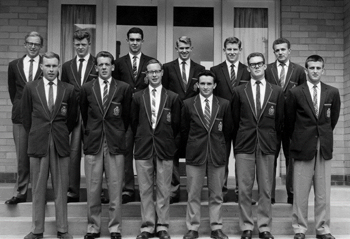
His application was handwritten and supposedly fairly rough but was supported by a couple of solid references. During the subsequent written exam in the Terang High School Principal’s office, Don struggled through and thought there was no way he would be accepted. Notification of an interview came as a great surprise; followed by even more amazement at being accepted for the three-year course at the Victorian School of Forestry (VSF) at Creswick from the beginning of 1959, along with 11 others. Don was only 16.
It was while at Creswick that Don met his future wife, Jan, a Ballarat girl, at a Church picnic.
Upon his graduation from VSF at the end of 1961 with a Diploma of Forestry, a full career path with the Forests Commission Victoria (FCV), and its successors, followed…
In 1962, like so many other young VSF graduates before him, Don was posted to the forest assessment branch.
His first job was camping at Horseyard Flat near the Moroka Hut in Gippsland to assess Alpine Ash timber stands. The next two to three years included assessing Red Gum at Lindsay Island on the Murray River between Ned’s Corner and Renmark. This was followed at Cann River and Errinundra Plateau to look for timber across large tracts of virgin forests. The bush was thick and full of snakes, scrub ticks, wild dogs, goannas and kangaroos. But the fishing in the wild and remote rivers was good.
In 1965, Don married Jan and secured a more stable job at Mansfield Forest District. This was followed with other FCV postings to Nowa Nowa between 1967 and 1971, then to Myrtleford as the Assistant District Forester between 1971 and 1977. It was here that Don completed his thesis on “Low intensity prescribed burning in three Pinus radiata stand types at Myrtleford”, to gain a Diploma Of Forestry (Vic).
From 1978 to 1979 Don worked at Taggerty before being promoted in 1980 to Rennick on the South Australian border as District Forester. His last posting with the FCV was at Erica from 1983 to 1985.
From mid-1983, the Forests Commission was disrupted when the State Government announced the creation of an amalgamated Department of Conservation, Forests and Lands (CFL).
The Commission then relinquished its discrete identity when it merged into the newly formed department, along with the Crown Lands and Survey Department, National Park Service, Soil Conservation Authority and Fisheries and Wildlife.
After the amalgamation, and prolonged restructure process, the tempo of change accelerated with many more departmental reorganisations and name changes over the subsequent decades.
Rather than looking backwards, Don took the changes in his stride and from 1985 he was appointed the Assistant Regional Manager of Public Land Management at Warragul to 1986, and then later in Traralgon to 1988.
One of the many initiatives of the new state government was the Timber Industry Strategy (TIS) in 1987. The TIS was a very innovative policy which introduced 15-year sawlog licences, regional sustainable yield, Forest Management Area Plans, the Code of Forest Practice, Harvesting Prescriptions and Forest Operator Licencing.
In typical style, Don faced problems by wanting to fix them once and fix them properly. A disciplined and fastidious administrator, he could sometimes become impatient at the rate of progress. But his prodigious work ethic led to the development of comprehensive timber harvesting prescriptions, which are still in use today.
Don also led a visionary project to calculate the long-term wood flows and define the new roading network to access stands of 1939 mountain ash regrowth across the Central Highlands.
Its centrepiece was building the South Face Road (SFR) which climbs steadily for 25 km, in an east-west direction, across the steep southern slopes of the Baw Baw Ranges in Central Gippsland.
The SFR was without doubt, the biggest and most complex road construction project that the Department had undertaken since the heady days in the late 1950s when the Forests Commission built the Tamboritha and Moroka Roads into the mountains beyond Licola. The SFR took 20 years to complete at a direct cost of $25 M.
Meanwhile, the forest conservation movement arguably reached the zenith of its influence and power in Australian politics in the late 1980s. And like so many other staff, having his stewardship and care of the State forests he loved being challenged, together with the sight of what he considered slovenly protestors blockading logging coupes, never sat easily with Don.
Firefighting in Victoria’s remote and rugged forests was an integral part of life for FCV foresters. It came with relentless toil, a sense of risk, achievement, comradeship, the smell of smoke, dirt and sweat, but with the tantalising prospect of a cold beer at the end of a very long day.
For his sustained firefighting service Don was awarded the National Medal, with a 40-year clasp in 1995, followed by the prestigious Australian Fire Services Medal (ASFM) in January 1999.
Between 1989 and 1997, Don was based in Traralgon as the Manager for Forests for Gippsland. And from 1997 to 2000 Don held the executive position of Manager of Commercial Forestry for Gippsland Region, where he became well known and respected in timber industry circles. His role also included statewide training, which he approached with his typical gusto and enthusiasm.
But like so many others, Don was eventually caught up in another of the relentless public service restructures and “downsizings” in mid-1999 and elected to retire in June 2000, aged 58, before he was really ready.
His premature departure left many saddened and loyal staff as well as a huge gap in the Departments shrinking pool of practical experience and corporate knowledge.
Rather than remain idle, Don took some consultancy work for a few years after retirement before moving to Inverloch in 2002, where he and Jan spent perhaps their happiest ten years before Jan died suddenly in 2012.
Don was always a volunteer, and in early years supported Scouts, then Lions, and Red Cross. He did countless trips from Inverloch to Melbourne hospitals transporting people to medical appointments for anyone who was willing to get into the car with him. His fondness for driving long distances at the drop of a hat was legendary.
A keen cyclist, Don was never deterred by a headwind or a long hill, but simply changed gears and pedalled harder.
And as a devoted South Melbourne Football Club supporter his faith never wavered.
Don was an enthusiastic member of the Retired Forests Commission Personnel Association (FCRPA) in his later years and could always be relied upon for some interesting insights. And as anyone who ever met him can attest, Don undoubtedly held strong views on many topics and was happy to share them.
In later years Don fought Parkinson’s Disease with his typical focus, grit and determination but it was a losing battle. He never wanted to leave Inverloch and the fantastic friends and neighbours he had.
Don Thomson died on 2 July 2022 at Doncaster in Melbourne surrounded by his loving family including his son Mathew and daughter Jo, and many grandchildren.
A man of boundless and infectious energy, Thommo left his mark wherever he went.
Written with the support of his family and many work colleagues and submitted to the Institute of Foresters of Australia (IFA).
Graduating class taken at the VSF in December 1961: Back (l to r) Geoff Beilby , Brian Fry, Mike Gardiner, Peter Lawson, Brian Vernon, Bob McKimm – Front (l to r) Ian Smith, Roger Smith, Jim Blain, Garry Leitch, Don Thomson, Colin Tolsher.
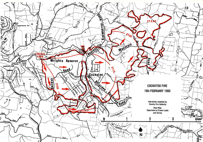
Cockatoo is a small village nestled into the southern foothills of the Dandenong Ranges were the suburbs meets the bush. Narrow gravel roads and modest fibro homes characterised the settlement.
The Cockatoo fire began late afternoon at 7.28 pm on Ash Wednesday 16 February 1983, about four hours after the blaze at Belgrave South. It was reported to the Forests Commission Victoria (FCV) office at Kallista by Jon Gwilt in the Briarty’s Hill firetower who could see smoke south of Macclesfield.
The fire was believed to been deliberately lit in at least two places in the Wright State forest near the Puffing Billy train line easement.
A professional fireman from the Metropolitan Fire Brigade (MFB) was detained by the CFA Captain and handed over to Police. He was charged with arson but later found not guilty in the Supreme Court.
At the time of reporting of the fire many local CFA fire trucks from the Dandenong Ranges and Pakenham Groups had been called away to the earlier fires burning at Belgrave South and Upper Beaconsfield.
The main Cockatoo CFA tanker had gone to Upper Beaconsfield and the remaining crew around town only had the F100 Ute. They were led by local Captain Graham Simpson. The main tanker later returned.
The police helicopter swooped over town and many people evacuated when they saw the smoke plume billowing up from the Wright State forest.
Dorothy Griffin was later awarded the Royal Humane Society Bronze Medal for assisting residents evacuate during the blaze.
Thankfully, the town had a mains water supply with diesel back-up pumps, and over a megalitre of water was used in the next 24 hours.
Forests Commission crews and tankers from nearby Gembrook and Olinda depots were also deployed to Belgrave South and Upper Beaconsfield. They were redirected to return immediately to Cockatoo and the Wright State forest which was within the Forests Commission’s Fire Protected Area (FPA).
Senior Gembrook overseer Bob Ferres took control of the FCV resources at Cockatoo. They arrived after 8.00 pm at Bailey Road to discover the two small fires had joined and were about 30 ha in size. The fire was spotting into private property in several locations.
Most of the bush hadn’t been fuel reduced for many years and the fire ran steadily under the influence of the northerly wind towards the Bailey Road – Majestic Road area.
They initially worked near the corner of Bailey and Paternoster Roads and were regularly kept informed by radio of the progress of the southwest wind change which was making its way across Victoria.
The District Forester from Kallista, Frank May, and Assistant Divisional Forester Harry Prewett went on a reconnaissance flight from Coldstream at 6.30 pm, with Bill Incoll from MFRS at Sherbrooke as their pilot. Frank was in contact with Bob Ferres by radio. They flew over the Belgrave, Upper Beaconsfield, Cockatoo, and later the Warburton fires, before returning around 8.40 pm for a briefing with the Divisional Forester Ken Harrop at Healesville.
The strong southwest wind change struck Cockatoo around 9.05 pm and the fire burnt back fiercely across the township at 9.10 pm. The Rate of Spread increased to 15 km/hr with long distance spotting and crown fires.
FCV crews rushed down Bailey Road under a hail of fire and a blizzard of burning embers. As they travelled towards Cockatoo, they picked up a man running along the road.
They also passed the CFA transit van from Nar Nar Goon engulfed in flames. The van was loaded of petrol and had been waiting for tankers needing to be refuelled when the wind changed. Aware that they were in immediate danger they tried to escape by driving through the smoke and flames, but the van overturned. The driver, Ranald Webster escaped with horrific burns to 80% of his body, while his CFA colleague, Eddie “Dasha” Lowen died in the van.
Ranald Webster was sheltering beside the road when he was picked up by Bob in the FCV Slip-on-Unit and taken to the Cockatoo medical centre. Ranald was given little chance of survival by ambulance driver Lance Simmons, but after years painful rehabilitation, Ranald went back to his job driving buses and made it his mission to help others, working with burns sufferers.
Bob Ferres and “Butch” Reid also passed a CFA tanker and picked up another three passengers. The Olinda FCV tanker driven by Kevin Curran caught alight as well.
It’s fair to say, the FCV crews probably saved the lives of all these people. The decisions made by Bob Ferres on the day also undoubtedly saved his crews lives.
There were many other acts of unheralded heroism that frantic afternoon. Some spoke of miracles.
Bob Ferres and the FCV contingent regrouped on the Gembrook side of Cockatoo at about 9.30 pm and worked through the night to save houses and lives as flames engulfed the town.
At the time of regrouping, FCV crews comprised 21 firefighters, 1 small First Attack Dozer (FAD) and 6 tankers. The CFA had 40 men, 3 dozers and 10 tankers. Four additional dozers had been requested but were hard to find under the circumstances.
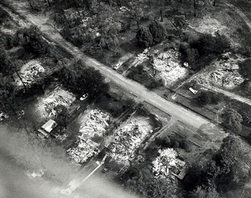
Two Forests Commission firefighters, Roger Frair and John (Charlie) Chaplin lost their homes in Cockatoo that night.
Charlie was with two others in the Olinda tip-truck fitted with a slip-on water tank. The headlights didn’t work so they scrounged some old electrical wire hanging on a fence and cobbled together a makeshift repair. The radio didn’t work either.
They were working to save houses on Knapton Avenue in Upper Beaconsfield and on their way to get more water when the wind change hit. The fire then swept over St Georges Road and Critchley Parker Junior Reserve where 12 firefighters from the CFA were killed.
The crew made their way to Charlie’s house in Cockatoo via the backroads because the road to Emerald was blocked by fire. His wife’s car was in the driveway and the Olinda Policeman, Jack Wicks, was standing out the front. Two people were lying dead in a nearby gutter. They were probably the young couple due to be married the following weekend, Anne-Maree James and John Merrick. Growing ever more anxious and not having a radio, they returned to the FCV Office at Kallista and were told that Charlie’s wife and daughter had safely evacuated to be with family at Carrum Downs.
Meanwhile, over 300 people, mainly women and children, sheltered at the Cockatoo kindergarten. Mrs Iola Tilley was their teacher. Local CFA crews surrounded the building at the height of the blaze. Many others gathered at the CFA shed causing traffic chaos.
The head fire ceased its run around midnight and was finally contained on the Gembrook – Lilydale Road but there were many spot fires sprayed out across the landscape.
One spot fire near Soldiers Road proved more difficult and was controlled a further 24 hours later by a small FCV crew from Sherbrooke and Kallista comprising 24 firefighters, 6 tankers and 1 quick fill pump.
Groups of school children were evacuated from Gilwell Scout Camp, Cooinda school camp and the FCV picnic ground at Kurth Kiln back to safety at Gembrook.
With the cooler weather on Thursday, backburning, blacking out and patrol continued along Beenak, Tonimbuk and Soldiers Roads for several days.
The media converged on the Cockatoo because of its proximity to Melbourne.
The Cockatoo fire #19 was one of the smallest in area of all the Ash Wednesday fires at 1,800 ha, but 6 people, including a CFA volunteer fireman lost their lives.
Over three hundred houses and seven major buildings were lost, and an estimated 1000 people were without their homes. 238 cattle and 97 sheep were also killed.
A large firebreak was cut near Second Avenue with SES bulldozers in the wake of the fire. Known as the “airstrip” it was 300 m wide and nearly a kilometre long but has now largely regrown.
State forest burnt in Fire #19 within the Fire Protected Area (FPA) included Wright State Forest, Soldiers Road near Kurth Kiln and Tonimbuk Road.
The fire was eventually declared safe by 6.00 pm on Day 12.
But months of relief… and years of recovery and rebuilding… followed.
This post should be read in conjunction with a story about the Belgrave / Upper Beaconsfield fire.
Taken from the house directly opposite emerald secondary college during the very early stages of the Cockatoo fire in the Wright State forest. Photo: Tonia Van den Dungen. Source: Christmas Hills CFA.Tom Van den Dungen watching moments later. Photo: Tonia Van den Dungen. Source: Christmas Hills CFAMany houses and cars were destroyed. Source: The AgeCaroline Ave Cockatoo after Ash Wednesday – Over 300 homes were lost and 6 people were killed. Source: The AgeThis photo was found in a camera shop in Melbourne’s CBD in late 1984. Someone had dropped a negative off in Feb 1983 to be printed and never returned. They told the shop owner that the photo is of Cockatoo on Ash Wednesday Feb 16th, 1983. The photo was taken just after the major wind change to the southwest, and the large bright glow on the left of the photo is the fire front roaring into the town. Tim Fitzgerald.Ian Macrea and his son Robbie, 15, carry their dog and a few possessions from the ruins of their home in Cockatoo, south-east of Melbourne, after the Ash Wednesday bushfires in February 1983. Picture: Mike ArthurRanald Webster was driving the Nar Nar Goon CFA Transit van loaded with fuel when it overturned and caught fire at the time of the wind change. He was badly burned and taken to the Cockatoo medical centre by FCV Overseer Bob Ferres also escaping the blaze. Ranald was given little chance of survival by ambulance officers. His CFA colleague Eddie “Dasha” Lowen died. Photo: Fairfax.Tent city sprang up to support the community. Source: The AgeInside the Cockatoo kindergarten. Source: NAAThe kindergarten at Cockatoo became an important refuge for the community. It has been repurposed as the Ash Wednesday Bushfires Education Centre. Photo: CFAPolice motorbike riding between Cockatoo and Belgrave after the Ash Wednesday fires. Source: Museum Victoria.Main street Cockatoo. Source: Ruth South.Newsreader, Brian Naylor at Cockatoo. Ironically, he was killed at his home at Kinglake West during Black Saturday bushfires 26 years later. Source: Ruth South.Source: NAACaroline Avenue Cockatoo after Ash Wednesday – Over 300 homes were lost and 6 people were killed. Source: The AgeThe clean-up went on for months. Photo: Graham Simpson, CFA Cockatoo.Source: NAALooking into the Wright State forest from the Monbulk- Gembrook road and the tree crown scorch after the fire. Source: NAAAnd the bush in the Wright State forest grew back. Source: NAAThe Wright State forest is situated north and west of Cockatoo and is fringed with modest residential development on narrow gravel roads. Slopes are moderate with mostly a northerly aspect. Creeks generally only run during winter and the main trees are messmate, brown and silver stringybarks with a hakea understory. Fuel loads were moderate to heavy. The north east corner had been fuel reduced and some tracks had been slashed. The two Points of Ignition were in the north west corner on Wright Road. Source: Helen Bull FCV Kallista.