The Upper Yarra Fire #12 erupted on Ash Wednesday, 16 February 1983, on the slopes of Mount Little Joe near Millgrove at 7.20 pm and quickly progressed under the influence of the strong north westerly wind.
Also often known as the Warburton or Powelltown Fire, it was first spotted by Jon Gwilt in the Briarty’s Hill firetower, and while the cause is unknown, most suspected arson. Another fire broke out in virtually the same spot in 1991.
Purely by chance, the Forests Commission Victoria (FCV), the Melbourne and Metropolitan Board of Works (MMBW), and the CFA were marshalling some tankers and equipment at Yarra Junction with the intention of heading to Belgrave South and Upper Beaconsfield when the Warburton fire broke out.
The Cockatoo fire also broke out at 7.28 pm.
By 7.50 pm the fire had grown to 100 ha and reached the summit of Mt. Little Joe. About an hour later at 8.40 pm, the fire had begun spotting through thick forest into the small sawmilling township of Powelltown, 14 km away.
Direct attack on the fire was too dangerous and ineffective, so crews were dispatched to warn landowners of the advancing blaze and to protect lives and property.
By 8.00 pm the FCV resources totalled 28 men, 2 tankers, 1 dozer and 3 Slip-On-Units. About 80 CFA volunteers on 20 trucks were also deployed.
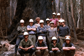
Ray Baker, the District Forester from Powelltown, was the Fireboss. Paul Mainey was the assistant forester and had been despatched to Trentham earlier in the day but returned on Thursday evening after being ordered by Ken Harrop, the Divisional Forester at Healesville. Forester Ron Harper assisted Ray during the initial run of fire.
The fire began spotting over the Old Warburton Road and calls were made for additional resources, but they were hard to find, with just about everyone and everything from the Forests Commission already deployed to other fires. Crews from Noojee that were on their way to Cockatoo were snaffled.
A little while later at 8.25 pm Briarty’s Hill reported the fire spotting over Britannia Creek Road, some 6 or 7 km from the origin of the fire.
By 8.40 pm the fire had spotted south of the Powelltown – Yarra Junction Road. This spot fire was to the west of the town and burning fiercely through thick messmate (E. obliqua) and silvertop (E. sieberi) forest with a very flammable wiregrass understory.
The hot wind was still from the northwest, but the change was imminent, when the main ground fire reached Podolinsky Hill near the township. The average Rate of Spread through the bush was 10.5 km/hr.
The southwest wind change arrived at 9.15 pm and split the fire in two. The northern front headed around Warburton township towards Reefton and the Upper Yarra reservoir, while the other near Powelltown moved back into the thick bush and headed towards Noojee.
And on the wind change, the small spot fire west of Powelltown burnt into a cleared area next to the FCV depot, nursery and office complex which was luckily spared.
Approximately 200 people took shelter at the local oval at Powelltown and at the town dugout. Residents from Reefton and McMahons Creek sheltered in a MMBW underground pipeline tunnel.
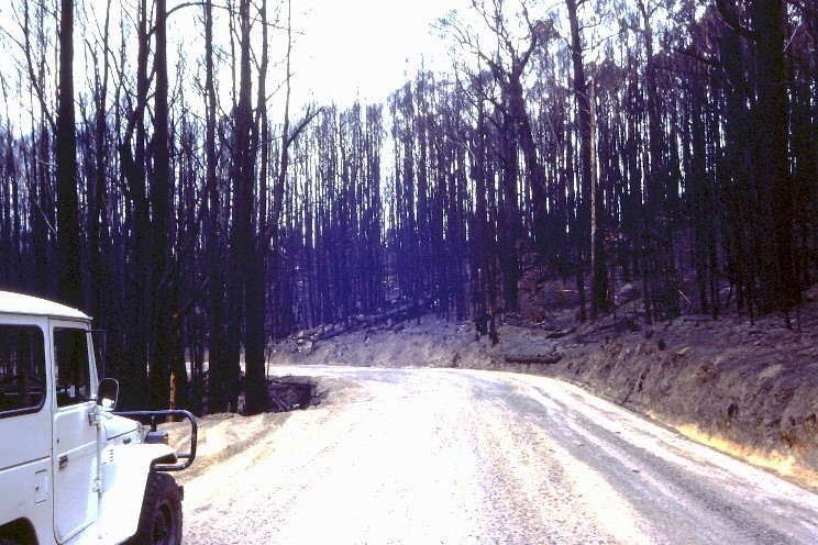
The fire continued throughout the night in the thick stands of mountain ash and messmate within the State forest. Because there was no threat to communities there was little point in mounting a suppression effort in the dark.
By midnight, the temperature was slowly dropping to 24 degrees with the RH hovering at 40%.
At about 04.00 am on Thursday a light drizzle began to fall at Powelltown as the temperature dropped even lower to 12 degrees. The rate of spread of the fire virtually stopped but it hadn’t gone out.
In the back of the fire controller’s minds was the blaze to the west of Powelltown near Kurth Kiln at Gembrook which had originated as a long-distance spot from Cockatoo. It was uncertain if more spot fires were still smouldering and undiscovered in the bush.
A reconnaissance flight was arranged at first light on Thursday with Assistant Divisional Forester Harry Prewitt to assess the situation and the damage.
By dawn at Powelltown there were 93 FCV employees plus 9 from APM with 8 bulldozers assembled to trail the southern edge and commence backburning. A further 30 FCV crew from Neerim south were deployed to the New Turkey Spur on the boundary of the two FCV Districts.
The Noojee township, which had been devasted by the 1939 bushfires, was evacuated and Police closed the Powelltown – Noojee Road.
Firebombers operated from Jessop airstrip near Noojee. The MAFFS was used to drop retardant on the main edge burning at the head of Alderman’s creek. Kevin Ritchie from Bendigo was the Air Attack Supervisor (AAS).
Basecamps were established at the Powelltown football ground, as well as the recreation reserve at Neerim South, with the support of the SES and Red Cross.
The northern tongue of the fire came out of the bush early on Thursday morning at 10.30 am when it crossed the Warburton Highway near the intersection of Brahams Road. Fortunately, the iconic stand of coast redwoods near Cement Creek, and the century-old Reefton Pub were spared.
The CFA had 60 units and 600 volunteers working at Wesburn, Reefton, Warburton and Gladysdale. The Metropolitan Fire Brigade (MFB) also sent appliances and crews from Melbourne to Warburton where there was a mains town water supply and were very effective.
On day 2, Thursday 17 February, the weather was mild with 22 degrees, RH 46% and a light south east wind of 10 km/hr.
Rod Incoll, the District Forester from nearby Toolangi was appointed night shift Fireboss while John McDonald from Alexandra and Andy Banks from Benalla, who had only recently transferred from Powelltown, took subsequent day shifts. Andy Beveridge worked at Neerim South.
The Navy sent 120 personnel from HMAS Cerberus, equipped with 110 fire beaters, 10 knapsacks and a mobile cooker to Powelltown on Friday to assist with fireline construction on Black Sands Road.
An Army crew, along with the FCV Mobile Support Crew (AKA Hotshots), worked in the O’Shannassy catchment alongside the MMBW to build a huge hand trail through the thick scrub.
There was a great deal of discussion about how to treat large patches of unburnt forest in the middle of the fire. Building a control line around the fire perimeter through the thick bush required a huge effort and may not be completed before the onset of more hot weather.
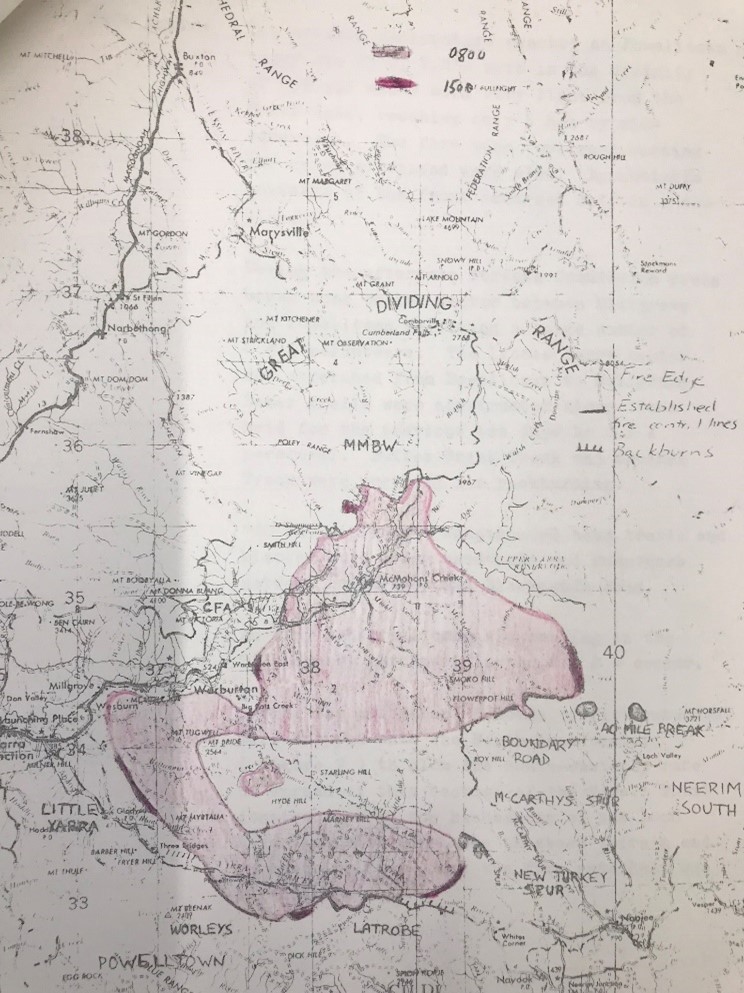
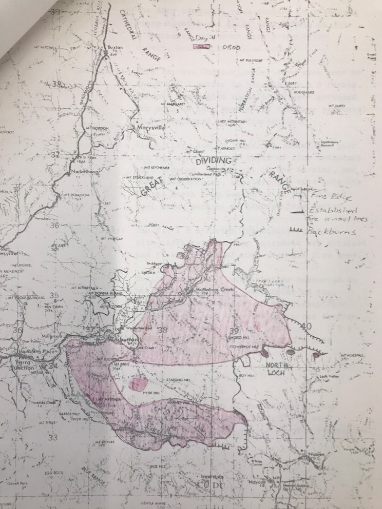
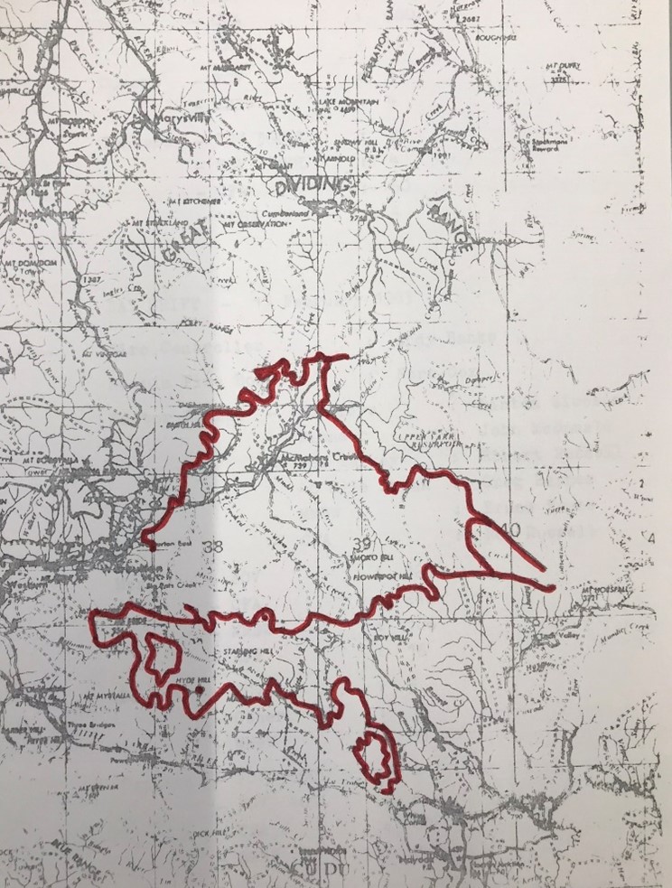
The CSIRO infrared Linescan was used on Saturday to map the fire boundary through the thick smoke. This is believed to be the first time the technology had been used operationally, and the image helped to develop a control strategy.
By Monday 21 February, the fire edge had stabilised, and backburning and aerial ignition was virtually completed in the expectation of more warm weather. However, 19 mm of heavy rain fell on Wednesday which extinguished most of the smouldering edge and made any further ignition impossible.
The rain enabled a major de-escalation of crews back to their home bases. The fires at Cann River were still burning and FCV crews were becoming exhausted with the repeated tours of duty.
However, the intense thunderstorm also caused major erosion of catchment slopes and gullies across the State forest. The rain which fell on Mt Little Joe created a mudslide of trees, rocks and debris to flow down a natural gully and completely block the highway to Warburton.
The fire also burnt the Yarra Tributaries and part of the Upper Yarra catchment which supply Melbourne’s drinking water.
Overall, 27 homes were destroyed in the Warburton Fire #12, but no lives were lost so there was no coronial inquiry.
The Warburton fire was one of the largest on Ash Wednesday with an area of 44,500 ha. It killed or severely damaged 4,979 ha of mountain ash forest while a further 12,636 ha were less severely impacted or unburnt.
Salvage of valuable timber commenced almost immediately before the logs dried out and degraded. Fortunately, the experience gained by the FCV in the salvage after 1939 was put to good use in a program that followed the fires at Warburton, Powelltown Bruthen, Broadford and Cann River. Softwood salvage included operations at Bright, Macedon and Geelong.
By the end of June 1983 some 16,600 cubic metres of sawlogs and pulpwood had been salvaged while over the next 12 months this increased to 443,000 cubic metres of sawlog and 239,000 cubic metres of pulpwood.
And while it was not on the same scale as the massive 1939 salvage program, it took over two years to complete the salvage with logging contractors coming from adjoining forest districts.


One thought on “Ash Wednesday 1983 – Warburton.”