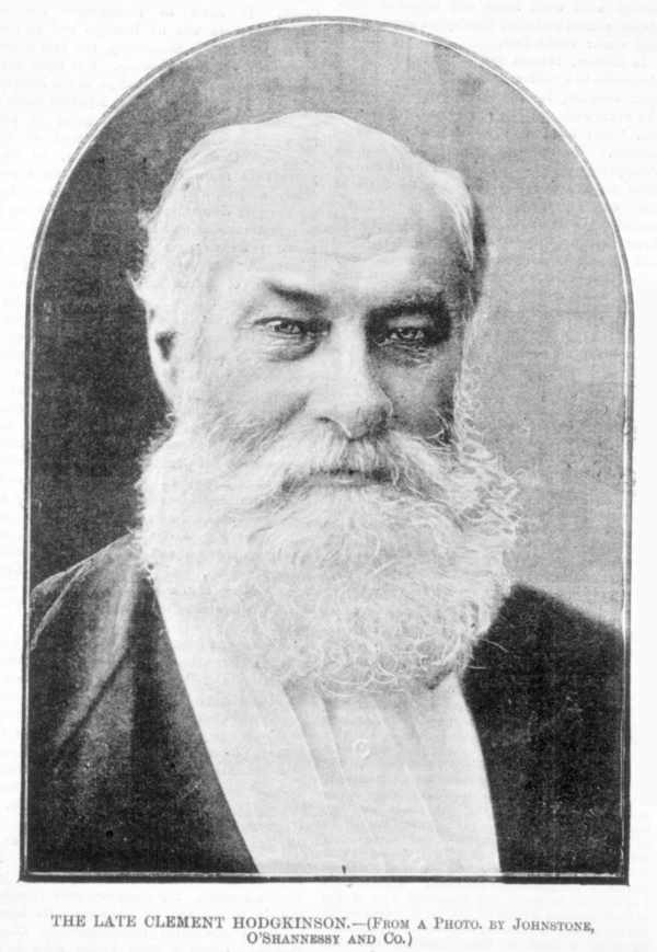
Clement Hodgkinson was as an English naturalist, explorer, senior public servant and surveyor.
Born at Southampton in 1818, he studied civil engineering in France before working at topographical fieldwork and mechanical drawing in England.
He arrived at Melbourne in December 1851 intending to become a pastoralist but instead joined the Surveyor-General’s Office in January 1852.
Clement rose to become Assistant Commissioner of Crown Lands and Survey from 1861 to 1874 where he exercised virtually complete control over the daily management of almost all Crown land reserves in Victoria.
Hodgkinson was widely acknowledged by his contemporaries, including the influential State government botanist Baron Ferdinand Von Mueller, as the “Father of Victorian forestry”.
The parliamentary inquiry in 1864-65 “On the Advisableness of Establishing State Forests” was led by Hodgkinson, together with the Surveyor General – Charles Whybrow Ligar and the Secretary for Mines – Robert Brough Smythe. Their report wholeheartedly recommended setting aside large State forest reserves in the vicinity of the goldfields at Ballarat, Sandhurst (Bendigo), Castlemaine, Ararat, Maryborough, Inglewood, Beechworth and other centres.
Following the inquiry and despite spirited opposition from agricultural, mining and grazing interests, Hodgkinson was almost single-handedly responsible for creating the first Timber Reserves in 1867. Many of these areas are now among Victoria’s finest National Parks and include Sherbrooke Forest.
Hodgkinson also appointed William Ferguson in 1868 as the first “Caretaker and Overseer of Forests”. Among other things, Ferguson established the first State Nursery at Macedon in 1872.
Hodgkinson served on many committees of inquiry, not least being the 1871 Royal Commission into “Foreign Industries & Forest”, a subject of major interest. He formulated the subsequent legislation to form Forest Boards in 1871.
Clement Hodgkinson retired from public service in 1874 but briefly returned to civic duties in 1883 to sit on a new Committee of Management to inspect the City Gardens.
He was also involved in what would become the Royal Society of Victoria, which discussed and advised the colonial government on scientific issues.
Flushed with tremendous wealth generated by the goldfields, the Victorian government invested over £9 million in the decade between 1854 and 1864 to build just 254 miles of railway, while private companies invested another £1.8 million.
The Victorian Railways Department was established in 1856, and the rail network rapidly began to radiate out from Melbourne. The first major country lines were to Echuca and Geelong to capitalise on freight traffic.
By 1870, construction of the lines to Ballarat, Sandhurst (Bendigo), and Echuca had been completed. While in the city, the suburban lines to the south and east were still privately owned, although the separate companies had amalgamated into one.
The tramways opened in 1884 which also rapidly spread across Melbourne’s inner suburbs.
Following hard on the heels of legislation to alienate and settle rural Victoria, two Acts of Parliament were passed in December 1880, and December 1884, which authorised the construction of 89 new railway lines, more than doubling Victoria’s network to over 2,900 miles by 1892. It included provisions to direct £200,000 per annum from the sale of public forests to fund the railway borrowings.
The legislation became notoriously known as the “Octopus Acts” in reference to the tentacle like web of tracks it created.
But the period was also characterised by blatant political interference in railway planning, with some parliamentarians shamelessly lobbying to have railways built through their own electorates, or even to serve land developments in which they had a direct financial interest.
The most famous example of political meddling was by the State Premier, Sir Thomas Bent, who was also the Treasurer and Minister for Railways. He had significant landholdings near Brighton and unashamedly approved a tramline from St Kilda, which led right past his properties to the new suburb of Bentleigh which he then pompously named in his own honour.
And it wasn’t just politicians, there are many stories of railway surveyors and engineers being lavishly entertained at country pubs and accommodation houses by local businessmen seeking to secure a more favourable alignment. Just think how many Railway Hotels there are across rural Victoria.
The period between 1880 and 1890 was then marked by a frenzy of railway construction as branch lines were constructed to serve new agricultural communities and to support suburban land speculation.
This network required nearly five million wooden sleepers, mostly from durable timbers like red gum sourced from the Murray River, ironbark near Bendigo and yellow stringybark and grey box from Gippsland.
In Victoria, sleepers typically measured 9 inches wide by 4.5 inches thick and 9 feet long, which roughly equated to a volume of 30 superficial feet.
During the 1880s, the annual demand for sleepers, just for maintenance and upgrades, was over 46,000, but in the subsequent decade the demand skyrocketed. In 1898 it passed 200,000, with 610,000 used for all purposes.
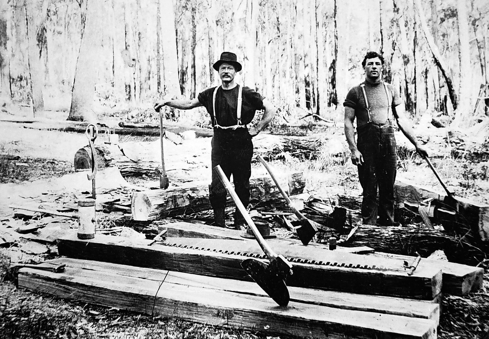
Thousands of sleeper cutters were employed and only the best quality timbers were acceptable to the Railways Department. They also preferred sleepers hewn by hand with a broad axe and adze rather than sawn. This was a very wasteful practice, with one or two sleepers cut from a tree with the remainder left to rot.
The newly appointed Conservator of Forests, George Perrin, was at constant loggerheads with the Railways Department over the wasteful cutting of sleepers. He unsuccessfully urged that sleeper hewers should be excluded from the forest and made clear his belief that they bore the bulk of responsibility for the destruction of Victoria’s valuable forest timber resources.
In addition to the provision of millions of sleepers, timber bridges also demonstrated the fundamental significance that State forests played in the rapid development of the new colony of Victoria.
From the early 1870s, the Victorian Railways maintained a policy of building all new bridges from timber to reduce costs, except in special circumstances which required the use of more permanent materials like brick, steel and concrete.
Although cheaper to construct, the timber bridges required more frequent and expensive on-going maintenance. Most of the key elements such as sleepers, girders, cross beams, piles etc would have been progressively replaced with locally sourced hardwoods.
Over 2000 wooden bridges were built on the railway network but most of these lines are now closed following the advent of better roads and vehicles.
The bridges then fell victim to decay, neglect, floods and bushfires, but a few operational bridges remain, mostly on heritage railways like Puffing Billy and Maldon.
The railways developed in conjunction with postal and telegraph services to provide communications for regional communities.
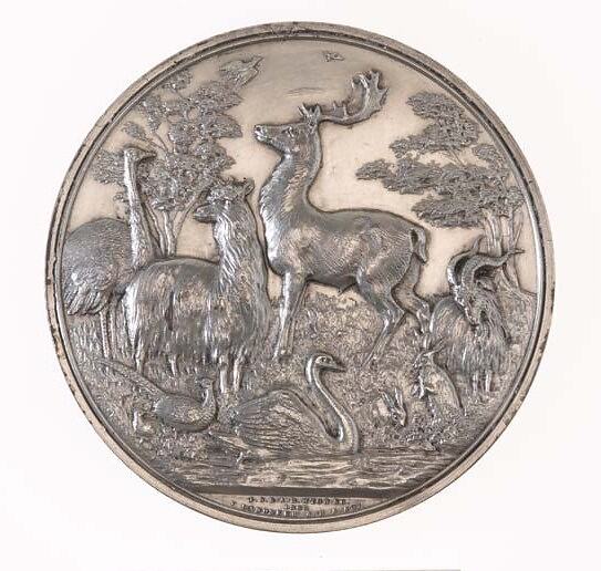
The Victorian Acclimatisation Society was founded in 1861 by Edward Wilson, editor of The Argus newspaper and a private collector, whose motto was “if it lives, we want it”.
The Society was governed by the colony’s most eminent scientists who believed that Australia’s plants and animals were greatly inferior to those in Europe, providing only “a little sport and an occasional meal”.
The Society was primarily responsible for the introduction of deer, starlings, Indian mynas, sparrows and European carp into the Murray River.
Wilson even suggested to the Governor of Victoria that monkeys be released into the Australian bush “for the amusement of the wayfarer, whom their gambols would delight as he lay under some gum tree in the forest on a sultry day.” Fortunately, his request was refused.
Victorian government botanist, Ferdinand von Mueller, a noted member of the Society, distributed thousands of living plants and packets of seed to gardens throughout the colony between 1857 and 1858. Von Mueller is often credited with the spread of blackberry, which now uncontrollably chokes the bush and waterways.
The release of 24 wild rabbits by Thomas Austin in October 1859 on his property near Winchelsea was also to have huge and lasting impacts on native forests and agricultural lands.
Foxes were introduced to combat the rabbits, but this experiment failed, and foxes became a new environmental pest.
Lack of ecological knowledge meant that the consequences of these introductions were generally unforeseen. It was later said of the Victorian Acclimatation Society that “there was never a body of men so foolishly, so vigorously, and so disastrously wrong”.
Domestic animals – such as dogs, cats, pigs and goats – either escaped or were released into the wild.
The list is long with other pests like black rats and scotch thistles which were inadvertently introduced by settlers.
And the later arrival of the soil-borne disease Phytophthora cinnamomi and the honey fungus, Armillaria luteobubalina, devasted large tracts of the southern eucalypt forests in Victoria, Tasmania and Western Australia.
As gold revenues declined, selling Crown Land to accommodate the thousands of new arrivals on farms and settlements became the next untapped frontier of wealth for the new colonial government.
Producing enough food for the expanding population was another important consideration.
Besides, farming was believed to provide a “healthy and pleasant pursuit” for ex-miners who might otherwise become “discontented and dangerous to public safety”. For many Irish immigrant families (like my own), who had been driven from their homeland by the potato famine, poverty and repression, a new life in agriculture in Victoria presented a more attractive alternative.
“Yeoman Ideal” was a popular and romantic belief in the worthy and noble figure of an enterprising and independent family-based farmer being the cornerstone of a prosperous rural society. It became a guiding principle of Victoria’s land settlement schemes.
To people from Great Britain – where every inch of land had been owned and traded for centuries – it must have seemed incredible that settlers in the new colonies of Australia could simply trek into the bush, mark out a large parcel of land and claim ownership without reference to anyone else.
The British Government, which claimed all land in Australia as terra nullius, stepped in and tried several different ways to regulate the system of private land ownership.
Not long after John Batman sailed up the Yarra River in 1835 to establish Melbourne, the squatters began arriving in Victoria, mostly from Van Diemen’s Land and NSW to illegally claim large areas of grazing land. The Henty Brothers had been squatting on Crown land at Portland from 1834.
In other examples, the Colonial government in Sydney either sponsored or sanctioned privately funded expeditions to search for new grazing lands and in return granted generous concessions.
By the end of 1838, according to the Crown Lands Commissioner, there were 57 squatters in the Port Phillip District.
“Squatters” carved out large estates on Crown Land they called runs and there was little the colonial government could do to stop them. They often objected to the term because it had originally been applied to ex-convicts who had illegally occupied small parcels on land. Instead, they saw themselves as “pastoralists”, an antipodean aristocracy living on large estates and homesteads built from the profits of the wool trade. But critics dismissed their upper-class pretensions by calling them the “squattocracy”.
In 1844, the Governor of New South Wales, George Gipps, required squatters to pay a yearly £10 licence fee and limited the size of each run. The license enabled the squatters to become legitimate pastoralists and to set up where they chose on Crown Land to graze cattle and sheep while waiting for it to be surveyed. The only limitation was that there would be three miles between stations.
Pastoralists then had a right to raise livestock on their “run” but licences could also be sold, and stations were constantly changing hands.
“Pre-emptive rights” were established in 1847 for squatters who had settled and made improvements to their land. They were permitted to purchase 640 acres (1 square mile) at the minimum upset price of £1 per acre. In this way the homestead, land and improvements could be secured before any surrounding land was made available to the public.
The squatters, who had good knowledge of their runs, claimed the best sections of land in a practice known as “peacocking”. The pre-emptive rights system was deeply flawed and widely abused.
By 1845, fewer than 240 wealthy squatters held all Victoria’s pastoral licences and proved a powerful political and economic force. They founded the exclusive Melbourne Club in 1838, which still exists today.
Prior to separation from NSW in 1851, there were five million sheep in the Port Philip District, but only 77,345 people. Wool was particularly profitable for these early pastoralists, and from the 1820s economic growth was based on the sale of fine wool to England which deeply shaped many Australian beliefs and identity.
After self-government was granted to Victoria in 1851, land continued to be administered under Imperial Acts and Orders-in-Council of the Governor of New South Wales. The first meeting of the Victorian Parliament wasn’t until November 1856.
At the time, the State’s forests and Crown Lands were still commonly regarded by the general public, and by most of their parliamentary representatives, as the inexhaustible “Wastelands of the Crown”, and ready for disposal via alienation and sale into freehold property for the purposes of agricultural settlement.
Influential and vocal segments of the community continually criticised the State Government for not exploiting and developing these remote and untamed lands.
But the Squattocracy and Land Barons were not about to cede their vast western district estates to settlers, nor their power in the Upper House of the Victorian Parliament. A pattern of conflict between the two Houses of Parliament continued for the next twenty years.
This growing resentment led to the formation in 1857 of the “Land Convention”, which began campaigning for reform. It was successful, and the Victorian Government introduced the Sale of Crown Lands Act (1860), also known as the Nicholson Act.
The Nicholson Act released 3 million acres of Crown Land for settlement and offered allotments between 80–640 acres of surveyed land at £1 per acre. Settlers could pay for half the allotment and lease the other half for up to seven years at one shilling per acre per year. Once the remaining balance was paid, they received a Crown Grant.
While there were some serious flaws in implementation of the Nicholson Act, this provision made an incredible difference to advancing land settlement. It also generated considerable and much-needed revenue into the colonial State Government coffers.
But the Nicholson Act provoked continuing confrontation with the squatters.
Access to water remained hotly contested, especially on the dry plains of northern Victoria. Pre-emptive rights typically secured access to reliable water in creeks or rivers. But in a visionary move, the Colonial Government established Crown Land frontages, which are narrow strips of public land along major rivers and streams. The law also forbade control of dual water frontages to prevent pastoralists from strategically monopolising all the permanent waterways for their own private use. A practice that could unfairly lock up the water resources and thereby excluding vast tracts of adjoining agricultural land from other settlers.
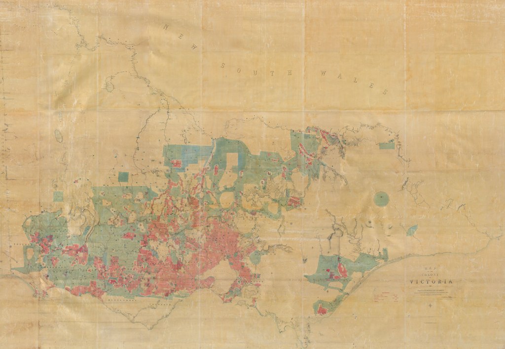
European settlement quickened with the passing of the Sale and Occupation of Crown Lands Act (1862), which was known as the Duffy Act, and attempted to resolve the conflict between squatters, gold seekers and small-scale farmers. The Duffy Act and subsequent amendments under the Grant Act (1865) released a further 10 million acres. The Act was accompanied by “the big map” which was one of the largest maps ever made in Australia, measuring 15 feet by 20 feet.
The term “Cocky” arose around 1870 to describe struggling farmers and settlers trying to scratch a living from the soil like cockatoos. But the nickname grew to reflect a sense of pride and self-assuredness, highlighting their resilience and connection to the land.
Importantly, a Section 41 of the Amending Land Act (1865), or Grant Act, allowed the Governor-in-Council to “…reserve from sale any Crown Lands which were required for the growth and preservation of timber…”. The Governor also approved the granting, cancellation, revocation, and transfer of licenses. The Act made provisions for bridges and level crossings.
The later Land Act (1869) allowed for the selection of up to 320 acres, including unsurveyed land, via the process of licensing, leasing and grants. A licence could be issued for three years at an annual rent of 2 shillings per acre, paid half yearly in advance. After that, the selector could apply for a seven-year lease at the same rent. After paying a total of £1 (20 shillings) per acre, the selector could apply for a Crown Grant, that is, land held by the Crown could be granted to the selector as the new owner.
Licence holders were also specifically barred from mining their selections under Section 20.
The Land Act (1884) was a revision of the earlier Land Act (1869), but under Sections 32 and 42 selectors had to pay the same price for land, £1 per acre, regardless of its quality.
This Act also allowed a grazing lease of up to 1,000 acres at an annual rent between 2d and 4d per acre, but the land could not be purchased and would revert to the Crown by 29 December 1898.
The 1884 Act also required selectors to make improvements, but those with poor-quality land could not make enough income to pay for the improvements.
For example, lessees of grazing areas were required under Section 32 to destroy all vermin within three years, enclose the land with fencing within three years and not remove timber except for use on the selection.
While licensees of agricultural selections under section 42 were required to destroy all vermin within two years, fence the land within six years, cultivate at least 1 acre in 10 during the licence period, occupy the land for at least five years and make improvements to the value of £1 per acre within six years. If these conditions were met, they could apply for a lease or Crown grant.
Needless to say, there was a lot of grumbling from cockies about the onerous provision of the 1884 Land Act. In 1898, the Commissioner for Crown Lands and Survey, Sir Robert Best, introduced fairer legislation to enable closer settlement and a new concept of land classification.
Settlers paid £1 per acre for half of an allotment but were required to make “improvements” regardless of its quality. They leased the other half for up to seven years at one shilling per acre per year and could pay off the balance at any time to receive a Crown Grant, which gave them ownership of the land.
However, Victoria was emerging from a financial depression in the 1890s associated with a post-goldrush hangover. It was also in the midst of the serious Federation Drought.
The Best Land Act (1898) also included a concession for existing agricultural leaseholders who were not able to pay arrears of rent.
The clearing of forests and timber by the early pastoralists for their sheep and cattle was intensified by the hopeful men who aimed to grow crops on their selections particularly from the 1860s onwards.
The latter tackled the more thickly forested areas which the squatters had avoided, such as the Otways and the great forests of South Gippsland.
The big trees were ringbarked in spring when the sap had risen. With a sharp axe the selector took off a one-foot strip of bark all around the tree and to make sure of killing large stems, chopped into the sap wood.
Although the tree remained standing, it soon lost its branches. This was a cheap way of “improving” the land as required by the selection acts. A competent axeman could kill three or four acres of trees a day.
The forested areas were frequently cleared of trees by fire which, more often than not, was not restricted to the landowner’s property but allowed to spread to adjoining forests.
The settlers were also permitted to obtain timber for their own use free of charge and this concession did little to instil a forest conscience in the community. A culture of forest destruction developed, almost without thought of the consequences.
During the 1800s, the State’s forests were controlled by the powerful Lands Department whose primary function was to survey, map and sell land for settlement.
Between 1849 and 1871 Victoria was divided into 37 counties and nearly 2914 parishes. These parishes were progressively surveyed by the Lands Department into allotments. This in turn allowed the colonial government to record the sale and transfer of land from the crown to selectors.
The Torrens Title system was introduced in Victoria in 1862 which provided a single record, or “Certificate of Title”, as conclusive evidence of land ownership. It gave confidence to land buyers.
However, there were still many serious allegations of coercion, and even corruption, within the corridors of power including the Lands Department, by those who sought to profit handsomely from the release and sale of Crown Land.
There was also evidence of “land banking” and “dummy bidding” whereby shady and wealthy speculators deceptively obtained land without actually occupying it, with the view to future sales and profits.
Furthermore, the colonial government viewed forests and wood as something that should be available for next-to-nothing for the large number of people battling to make a subsistence living from the earth. The government exerted only the lightest of controls in the form of annual licences to obtain timber for a modest sum, with no restrictions on species, sizes or quantity. Vast quantities of timber were felled by squatters and selectors and wasted.
While timber cutting for the mines during the goldrush had huge impact on the State’s forests, they were often left to regenerate naturally. Whereas clearing for agriculture was the primary cause of permanent forest removal.
By 1878, about 40% of the Colony had been alienated which coincided with its first surplus of food.
Not surprisingly, the Colonial Government had little appetite for changing the status-quo and introducing restrictive forest legislation.
However, the era of land alienation basically came to an abrupt end around 1925, with only minor acreages after that. Foresters and the newly formed Forests Commission played an important part in that massive change by pushing back against the Lands Department and calls for more land to be released.
The other key forces were a rising “forest conscience” within the community, and the political pressure of the big gold mining companies and the parliamentarians representing mining town electorates. They were seeing a timber drought firsthand with shortages of structural timber for pit props and firewood for boilers to run mining machinery. Shortages due in large part to deforestation in central Victoria caused by mining with no reforestation or planting.
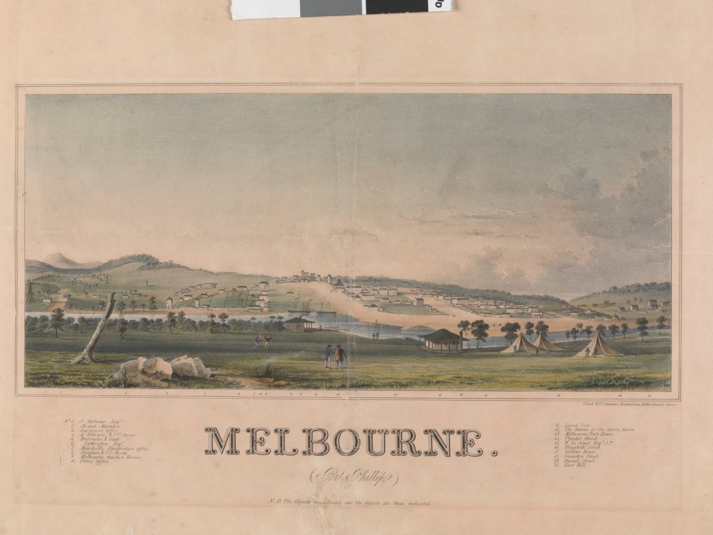
Squatting map of Victoria (Port Phillip District, New South Wales) – 1853. Source: SLV http://handle.slv.vic.gov.au/10381/119452“Surveyors” by colonial artist Samuel Thomas Gill, Plate 17 from “The Australian Sketchbook” – 1865. National Gallery Victoria.The Duffy Map (aka the Big Map) measures 15 feet by 20 feet and was created for the Parliament to show land available for selection in 1862. Crown land (in blue) would ultimately be available for “selection”, while those lands (in red) were already owned by individuals. Most of the big uncoloured blanks were “Wasteland of the Crown” which later became unalienated Crown lands and State Forests. https://www.nma.gov.au/exhibitions/not-just-ned/behind-scenes/scenes/duffy-map-installation Port Phillip District, now Victoria, showing spread of pastoral occupation by 1934. Source: SLV: http://handle.slv.vic.gov.au/10381/287353The Pioneer by Australian artist Frederick McCubbin. National Gallery of Victoria. https://www.ngv.vic.gov.au/frederick-mccubbin-the-pioneer-1904/
The Marvellous Melbourne we enjoy today began to take shape in 1854 and was paying for it in gold. They were heady times.
The MCG, Flinders Street Railway Station, Port Melbourne’s Station Pier, the University of Melbourne, both St Paul’s and St Patrick’s Cathedrals, the Royal Botanic Gardens, Customs House on the Yarra, while the Melbourne Museum and the State Library shared a site in Swanston Street. All of these and many more venerated public landmarks got their modest start in 1854.
The first edition of the Melbourne Age was also printed on 17 October 1854.
Melbourne’s own “Crystal Palace” was constructed of glass and wood in 1854 on the corner of William and La Trobe streets (now the site of the Royal Mint). It boasted 23,000 square feet of floor space and was built in just 70 days. The first of its type in Australia, it was designed to show off the gold-rich colony.
Australia’s first steam-powered city train, operated by the Hobsons Bay Railway Company, choofed on its first short journey on June 12, 1854, a full year before Sydney had any form of railway.
The thirsty citizens of Melbourne received their first public water supply in 1854, when a 150,000-gallon tank was built in East Melbourne, initially storing water raised by a steam pump from the Yarra River before the Yan Yean Reservoir came on stream three years later.
The goldrush lured thousands of hopefuls from around the world: Americans fresh from their own rush in California, arrived alongside Germans, Scandinavians, South Africans, Brits and Chinese among others.
Australian history was being made in other ways on the goldfields that were feeding Melbourne’s enormous wealth. And before 1854 was done, out on the Ballarat diggings, a ragtag gathering of miners fed-up with unjust treatment from the colonial authorities made the Eureka Stockade and the Eureka flag hopelessly romantic symbols of rebellion within the Australian story.
The explosion in immigration and the consequent demand for imported goods, presented Victoria’s administrators with their own bottomless money pit.
In addition to the hated mining licences, duties were levied on all imported luxuries brought into the suddenly wealthy colony, while a tax was levied on the export of gold. Customs revenue in 1850, immediately before the goldrush, was only £84,000, but by 1854 customs officers collected the same amount in a month.
To avoid the tax, ships carrying Chinese passengers dropped them off in Sydney, Port Adelaide and Robe in South Australia – requiring them to traipse many hundreds of kilometres on foot to the goldfields.
When the huge number of gold-seeking immigrants, at first housed in tents and crowded lodgings, finally turned their attention to more permanent accommodation, housebuilding leapt to a new level of activity with a 50% increase in the first few years of the 1860s. Steam powered sawmills together with the mass production of nails, and access to corrugated iron (rather than English thatch which was very fire prone), enabled thousands of new timber houses to be built. This added considerably to the pressure on the native forests.
But the goldrush and Melbourne boom petered out by 1880s and was inevitably followed by a financial crash in 1891, which combined with the Federation Drought from 1895 to 1902, depressed economic conditions for a decade or more.
But in February 1854, an Act to Restrain the Careless Use of Fire was passed.
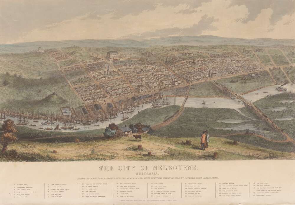
The City of Melbourne drawn by Nathaniel Whittock made from official surveys and sketches taken in 1854 by Goodman Teale. Source National library of Australia.
The distance from Melbourne to Sydney often frustrated and delayed important government decision making when Port Phillip was still a reluctantly dependent outpost of New South Wales. It was one of the main reasons that Port Phillip residents passionately advocated for a separate and independent government.
A Separation Association was formed following a public meeting in Melbourne in 1840 to protest about the perceived indifference by Sydney administrators, as well as the unequal distribution of public infrastructure funding. The Association then petitioned the British Parliament in London. Maybe as an appeasement the Port Phillip District was granted minority representation in the New South Wales Legislative Council in 1842.
Finally, on 1 July 1851, after years of agitation, the District of Port Phillip separated from NSW to become the independent Colony of Victoria. Although the first meeting of the Victorian Parliament wasn’t until November 1856.
Meanwhile, there had been evidence of small quantities of gold in Victoria as early as 1849. The Black Thursday bushfires in February 1851 removed the thick undergrowth and opened up the forests, the rivers and outcrops of rock for eager prospectors.
The new Victorian Governor, Charles La Trobe, assembled a Gold Discovery Committee on 9 June 1851 which offered sizable rewards to anyone who found payable amounts of gold within 200 miles of Melbourne. The response was immediate because the precious metal had already been discovered, but the prospectors had kept quiet.
Within weeks of Victoria’s formal separation from NSW, news broke out about gold discoveries at Warrandyte and Clunes, and by the following month new finds were also made public about Castlemaine, Bendigo and Ballarat. Further discoveries were made at Beechworth in 1852, Bright, Omeo, Chiltern (1858–59) and Walhalla (1862).
Governor La Trobe visited Ballarat and witnessed a team of five men dig out 136 ounces of gold in one day and another 120 ounces on the following day. The richness of these finds was staggering.
Prior to the goldrush, Victoria was primarily a pastoral settlement with a European population of 77,345. But when gold was discovered, the population suddenly swelled. Three years afterwards in 1854, the population had tripled to 231,925 and by 1857 it had reached 410,766.
The economy deteriorated into a shambles for a time as people deserted jobs and farms to head to the goldfields. Vessels arriving with hopeful diggers at Williamstown in Port Phillip Bay were often left abandoned as the crews jumped ship.
The 1850s goldrush led to heady and unrestrained prosperity for the new colony, and the City of Melbourne became its financial capital. Many magnificent public buildings were constructed, and the rail system began to radiate from its centre.
However, the urgent need for timber to feed the gold fields had a profound and lasting impact on Victoria’s native forests. They were being progressively and indiscriminately cleared, in ever-increasing concentric circles, for mining and building timbers.
The Government had become beholden to the needs of the mining industry and practically no restrictions were placed in the way of its easy and cheap procurement of timber.
No value whatever was given to the boundless forests, and it was only because of the necessity of going further and further afield for pit props, laths and other wood necessities for the mines that any thought was given to the conservation of forests.
The spirit of forest destruction engendered by the powerful mining community became a state characteristic for many years to come.
Power for sawmills and mines was primarily supplied by steam, and in 1873, it is estimated that some 1150 steam boilers in the gold mining industry were indiscriminately devouring over one million tons of firewood each year.
By 1859, there were 71 sawmills but during the 1860s, this number expanded to 141.
The gold mining frenzy not only devastated the native forests, but it also churned the soils, the landscape, and the waterways, which left scars that took decades to repair.
Indeed, gold made Victoria and Melbourne, but at a terrible cost to the native forests.
In November 2024, a small group of cheerful volunteers from the Forests Commission Retired Personnel Association (FCRPA) toiled over nine days to dust-off, photograph and record nearly 300 artifacts in DEECA’s Altona Museum.
It followed a similar project at the FCRPA’s Beechworth Museum in February 2024.
The Altona project was generously supported by DEECA / FFMVic to engage professional photographer Mark Jesser from Wodonga whose boundless energy and good humour helped to create these amazing images.
Special thanks go to the FFMVic Chief Fire Officer, Chris Hardman, as well as Andrew Stanios and Kat Jensen for making it happen.
FFMVic crews and the ever-patient staff from Altona took a strong interest and also helped to shift some of the heavy items like pumps and the Bedford tanker which was very welcome.
The Forests Commission and its successors continuously encouraged bushfire research and innovation. In 1946 a large parcel of industrial land was purchased at North Altona as a fire cache and workshop.
The Altona workshop became a hotbed of new technological thingumajigs… a marvellous blend of Aladdin’s Cave of Wonders coupled with Wallace and Gromit’s madcap contraptions… an exhilarating place where lots of gizmos were invented and tested… mostly with astounding results… but nearly always with some head-scratching frustrations… and thankfully not too much explosive mayhem.
In fact, a lot of Australia’s pioneering equipment development was led by staff from Altona, often in collaboration with other State forestry and fire authorities. The CSIRO also contributed significantly.
The US Forest Service, the US Bureau of Land Management and US State agencies such as the California Department of Forestry and Fire (CalFire) as well as the Canadian Forest Service faced similar challenges and proved strong and willing partners in sharing knowledge, ideas, equipment and expertise over many decades.
The collection at Altona was accumulated over many years by fire equipment wizard Barry (Rocky) Marsden.
The items at Altona represent just a small sample of the amazing story of Victoria’s forestry and bushfire heritage.
The largest item was undoubtedly the Bedford tanker which took two days and nearly 1000 photos which were later stitched together with photoshop. The oldest item is probably a daylight signal lamp from 1918. There are also many unique items, but the CSIRO incendiary machine and ping-pong incendiary machine developed at Altona probably had the most significant impact on fire management in Australia. There are plenty of gaps in the collection, but some items are in regional DEECA offices.
It’s hoped to merge the FCRPA’s Beechworth collection to Altona one day and rename the site to honour Rocky Marsden.
There may be some additions to the Altona museum over time, but space is limiting. There are still a few shipping containers full of stuff at Altona and Laverton to be sorted through.
Victoria’s largest recorded bushfire occurred on Black Thursday, 6 February 1851, which is often claimed to have burnt up to 12 million acres (5m ha), or about a quarter of the State.
By comparison, the Victorian bushfires in 1939 burnt 2 million hectares, while Black Summer of 2019-20 burnt 1.5 million ha.
It must also be said that the 1851 figure is probably inflated and unreliable because of the sparseness of witnesses, the largely unpopulated rural areas, combined with somewhat sketchy but colourful newspaper reports.
Interestingly, later explorers, surveyors and foresters found remnant stands of very large and very old trees in the mountain forests of the Central Highlands, the nearby Dandenong Ranges, the Yarra catchments, the Otways and the Strzelecki Ranges in Gippsland, as well as the snow gums in the Alps. These forest types are very susceptible to bushfire, which points to a lesser extent of the 1851 bushfire.
We will never know…
But what is now recognised as a typical Victorian weather pattern was emerging.
Two years earlier in the winter 1848 there was heavy rainfall, which was followed by high temperatures over the summer of 1848–49, which began to dry out the forests.
During the following winter of 1849 snow fell in Melbourne with more heavy deluges and floods. This rainfall no doubt led to a build-up of fuel in the forests and grasslands.
The summer of 1850-51 was long and hot with many uncontrolled bushfires about the ranges fringing Melbourne.
Thursday 6 February 1851 was one of the hottest day the European settlers could remember, and a fierce wind increased throughout the day. The Argus newspaper later reported.
Thursday was one of the most oppressively hot days we have experienced for some years. In the early morning the atmosphere was perfectly scorching, and at eleven o’clock the thermometer stood as high as 117° in the shade; at one o’clock it had fallen to 109 ° and at four in the afternoon was up to 113°.
Similar temperature extremes in Melbourne were reached again during major bushfires on Red Tuesday – 1898 (107°F), Black Friday – 1939 (114°F), Ash Wednesday – 1983 (109°F) and Black Saturday – 2009 (115°F).
The hot north wind was so strong that thick black smoke reached northern Tasmania,
It was also later reported that the intense heat could be felt 20 miles out to sea from Portland where a ship under the command of Captain Reynolds came under burning ember attack and was smothered by a blizzard of cinders, smoke and dust.
Eventually, a typical south westerly breeze and light rain cooled the land.
It’s hard to know the source of the ignitions, but historians suspect it was settlers clearing the land and prospectors in search of gold.
Remarkably, there were only 12 known deaths, no doubt because of the relatively small population of only 75,000 Europeans at that point, with about one third living in Melbourne.
The impact of the bushfires on the indigenous population is not recorded. It’s also unknown to what extent the disruption of traditional aboriginal burning patterns by 1851 may have contributed to the build-up of understory fuel.
But the discovery of gold and the huge population surge was only months away.
After some years of agitation, Queen Victoria signed the Australian Colonies Government Acton 5 August 1850 to separate the Port Phillip District from NSW to create the new independent Colony of Victoria.
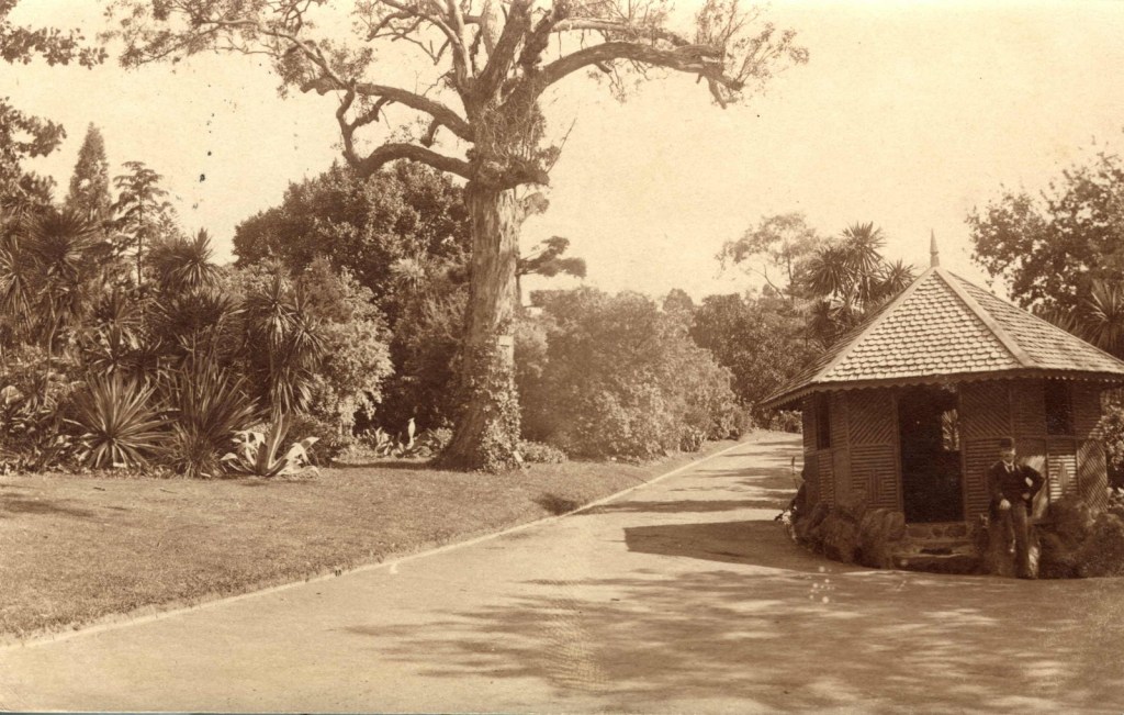
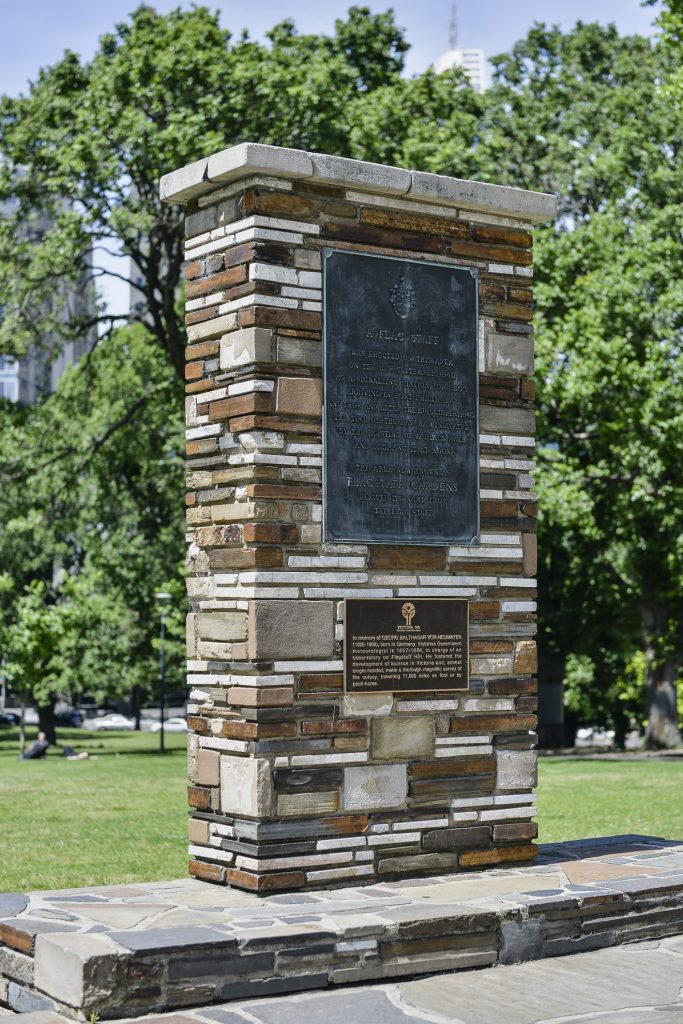
When the news reached Melbourne from London on 11 November 1850 it was announced with great flourish under a tree at the northern end of the current Flagstaff Gardens.
The news about forming a new colony was then signalled to Melbourne residents by lighting a huge bonfire on Flagstaff Hill and putting up posters around the city.
Four days later on the 15 November, Governor Charles La Trobe led official celebrations in the Royal Botanic Gardens under a giant red gum that became known as the Separation Tree.
The legislation didn’t come into full effect until 1 July 1851.
Sadly, this magnificent tree was vandalised in 2010, and again in 2013, and subsequently died.
A poster dated 11 November 1850 from the Melbourne Morning Herald urges citizens to celebrate the new colony of Victoria. Source: State Library. http://handle.slv.vic.gov.au/10381/116207
The present-day State of Victoria had a hesitant start.
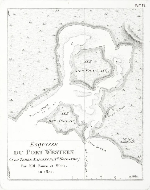
George Bass sailed from Sydney in 1797 in an open whaleboat with a crew of six on an epic and perilous journey to explore the southern coast. He travelled around the southern tip of Wilsons Promontory to land at the entrance to Western Port Bay near present-day Flinders.
Shortly after in February 1802, Lieutenant John Murray, aboard the Lady Nelson, entered Port Phillip Bay and formally took possession for Britain. Captain Matthew Flinders arrived 10 weeks later and climbed two major peaks at Arthurs Seat and the You Yangs. Their combined reports to Governor King influenced the decision to establish Victoria’s first official settlement in the following year.
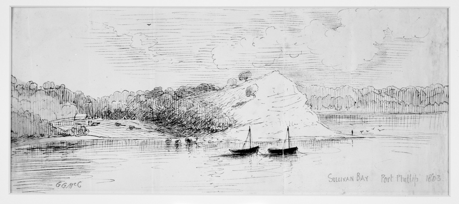
Lieutenant-Colonel David Collins first settled at Sullivan Bay near present-day Sorrento with a group of British convicts in October 1803. However, a lack of fresh water, poor sandy soil and shortages of timber suitable for building, together with violent clashes with the local Aboriginals, led to Collins to recommend a move to the Derwent River in Van Diemen’s Land, and upon receiving permission, he left in two ships on 30 January and 20 May 1804 to establish Hobart.
Between 1801-04 the voyage of the French explorer Nicolas Baudin charted much of the southern coastline including Western Port Bay and French Island. He included the description of “La Terre Napoleon”, covering much of what is now Victoria and South Australia. Onboard was artist Charles Alexandre Lesueur who drew exquisite sketches of the east coast of Tasmania in 1802 which show many small plumes of smoke from Aboriginal fires.
Starting from NSW in October 1824, Hamilton Hume and William Hovell began an expedition southward to find new grazing land. They spent three days attempting to cross the Great Dividing Range at Mt Disappointment but were thwarted by the thick mountain forests. They eventually reached Corio Bay on 16 December, but because of navigational errors and omissions they mistakenly concluded that they had reached Western Port. However, their enthusiastic reports led NSW Governor Sir Ralph Darling to establish another short-lived convict settlement at Corinella at Western Port in November 1826, in part to protect the approaches from French explorers.
Between 1829 and 1830, Charles Napier Sturt led an expedition along the Murray River, sparking interest in the vast red gum forests and potential for settlement of land to the south.
Meanwhile, the Henty brothers established a permanent settlement near Portland in 1834. They had been disappointed with the Swan River in Western Australia and were unable to secure a land grant in Tasmania, so they squatted illegally with their flocks of sheep.
Major Thomas Mitchell’s famous overland expedition arrived at Portland in August 1836, and he was surprised to find the small but prosperous community living off the fertile farmland. He termed the region “Australia Felix” which is Latin for “Fortunate Australia”.
A year later in 1835, Australian grazier, entrepreneur and explorer, John Batman, led an expedition from Tasmania and claimed to have negotiated the purchase of over 600,000 acres of land between Port Phillip and Corio Bays from eight Wurundjeri elders in exchange for tools, blankets and food. He also famously identified a spot on the Yarra River which was to become the City of Melbourne and noted in his diary of 8 June 1835, “this will be the place for a village”. But Batman’s treaty was deemed illegal and subsequently rejected by Sydney-based Governor Sir Richard Bourke because Batman had no authority over Crown Land.
Crown Land was the principal asset of the British colonial government and its major source of power and revenue. To discourage similar illicit ventures in land dealing, the Sydney Government made Port Phillip a formal administrative division of New South Wales in September 1836 and established a magistrate’s office at Melbourne to administer new land regulations.
Pastoral runs spread over the following two years as far as Winchelsea, Inverleigh and Bacchus Marsh in the west, and Woodend and Kilmore in the north.
Timber licence regulations were also established under the Land Act which proved largely ineffective.
The timber industry was one of the first to establish in Melbourne to provide the raw materials for construction of buildings, wharves and fences. However, the pioneers of Port Phillip were largely from Tasmania, and they preferred to ship timber from sawmills and forests around Launceston and Hobart.
Melbourne’s first steam-powered sawmill was established by Alison and Knight in 1841 on the south-east corner of Collins and King Streets. And the first timber tramway in Victoria was built on the Portland jetty in 1846 to move loads between ships and the shore.
The main early explorers who ventured into the deep forests and mountains peaks of Gippsland included Angus McMillan in 1839 and Count Paul Strzelecki in 1840.
Prior to European discovery and settlement, Victoria was the home to many indigenous nations who had occupied the land for thousands of years and, over that time, had accumulated a deep knowledge and wisdom of the natural rhythms of the bush and fire.
The pre-colonial Aboriginal population of Victoria was estimated to be about 70,000, but European diseases such as smallpox decimated communities and reduced this number to less than 15,000.
Major impacts on native forests also occurred with the dispossession of Aboriginal people from their traditional lands between 1836 and 1842 associated with the establishment of extensive sheep runs. By 1845, fewer than 240 wealthy squatters held all the pastoral licences and became a powerful political and economic force in Victoria. There was often conflict between the new settlers and aboriginal communities over land and resources.
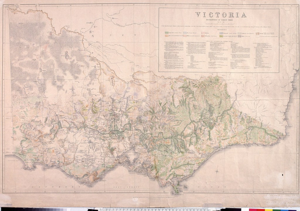
A map produced by the Mines Department in 1869 indicates that prior to European settlement, nearly 88% of Victoria had been forested, with the remaining 12% made up of open grasslands, coastal and alpine heathlands, lakes and mallee deserts. Alienation and sale of Crown Land with associated clearing of native forests for mining, roads, railways, pastures, agriculture, cities, towns and settlements over the subsequent century reduced this figure to about 36% by 2013.
The first European seafarers, explorers, surveyors and settlers witnessed and commented on aboriginal groups frequently lighting small and low intensity fires to burn the scrub. They also noted the open grassy forests and woodlands which they encountered.
Disruptions to the complex patchwork associated with traditional indigenous burning patterns undoubtedly led to profound changes to the state of Victoria’s native forests, particularly of the structure of the understory.
There is also strong evidence from pollen and charcoal particles found in lake sediments to suggest that major bushfires were more intense and more frequent following the arrival of Europeans.
By the late 1840s only about 75,000 Europeans occupied Victoria with Melbourne, Williamstown, Geelong and Portland as the dominant settlements. But the gold rush beginning in 1851 created a flood of miners and new settlers looking for land which led to major and lasting impacts on Victoria’s forests.
Distribution of Victoria’s forest trees. Prior to European settlement, nearly 88% of Victoria had been forested. Victorian Department of Mines 1869. University of Melbourne digital collection. https://digitised-collections.unimelb.edu.au/handle/11343/23731
Over the last few years I have written nearly 1000 short Facebook stories and lodged eight free eBooks in the state and national library. There are also more than 20 Wikipedia pages.
This year will see a shift of focus to writing a book about “The Working Forests” which seeks highlight the importance of our forests and the role they played in Victoria’s economic and social development since the 1840s.
I plan to interview a number of people and visit some important forest sites across Victoria this year.
The book will include the key roles that foresters played as early stewards and advocates for forest use, forest conservation, and protection from bushfire.
It will tell some stories of the wide and diverse cast of characters who have interacted with our forests – from foresters and firefighters, to local communities, to conservationists, to post cutters, logging contactors and sawmillers, and the many forest users.
The diverse range of products and benefits that State forests provide will be highlighted. “Balance” and “Multiple-Use” have been recurring themes for the management of our forests over many decades.
I also hope to explain the complexity of the evolving community and political attitudes towards forests and bushfires, together with the progressive shifts in the balance of their preservation and productive use.
The recent cessation of timber harvesting in Victoria’s is raw and remains controversial but is the conclusion of a long and complex backstory.
Looking back over the life of the Forests Commission, many things are apparent… like being a field-based organisation with stable and experienced leadership, staff having pride in their work and a strong “can-do culture” of getting the job done consistently shines through.
The family ancestry of the current organisations such as the Department of Department of Energy, Environment and Climate Action (DEECA), Forest Fire Management Victoria (FFMV), Parks Victoria, VicForests, Alpine Resorts, Catchment Management Authorities (CMA), Hancock Victorian Plantations (HVP), and even the Country Fire Authority (CFA) can all be traced back to this earlier era.
Importantly, the Forests Commission left a strong legacy of tradition, camaraderie and spirit of innovation which remains embedded in the DNA of these modern organisations today.
There were many “firsts” … and a lot to be proud of…
I believe the story of our working forests needs to be told before it is lost, forgotten or falsely reinterpreted by others.
I intend to publish “The Working Forests” as another free eBook by the end of 2025.
The project is being generously supported by Eucalypt Australia with a Dahl Fellowship.
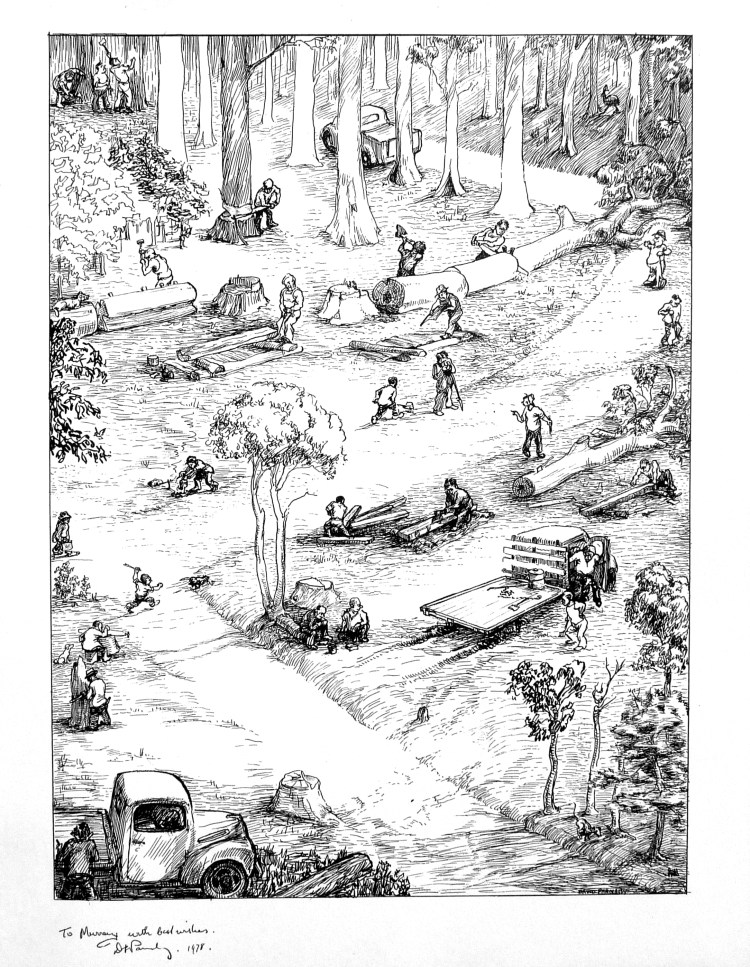
Drawing by David Parnaby of the antics of the sleeper cutters at Cann River in the 1950s.
The Sleeper Cutters – Cann River. David Parnaby graduated from the Victorian School of Forestry in 1940 and initially worked in Assessment Branch. He later had District postings at Heathcote, Powelltown, Dandenong Ranges, Bruthen and Beechworth. Promoted to District Forester in 1951, David was moved to Cann River, then Heathcote (1955), Castlemaine (1958) and Daylesford (1971). Following a period with Forest Protection in Melbourne he retired in 1980. David was an accomplished cartoonist who provided insightful and humorous commentary through the Victorian State Forester’s Association Newsletter. His keen eye for the antics of sleeper cutters at Cann River in the 1950s remains a classic. The more you look at this, the more you will see. This copy was a gift to the FCV’s Chief Forest Assessor, Murray Paine, in 1978 and is now with Gregor Wallace.
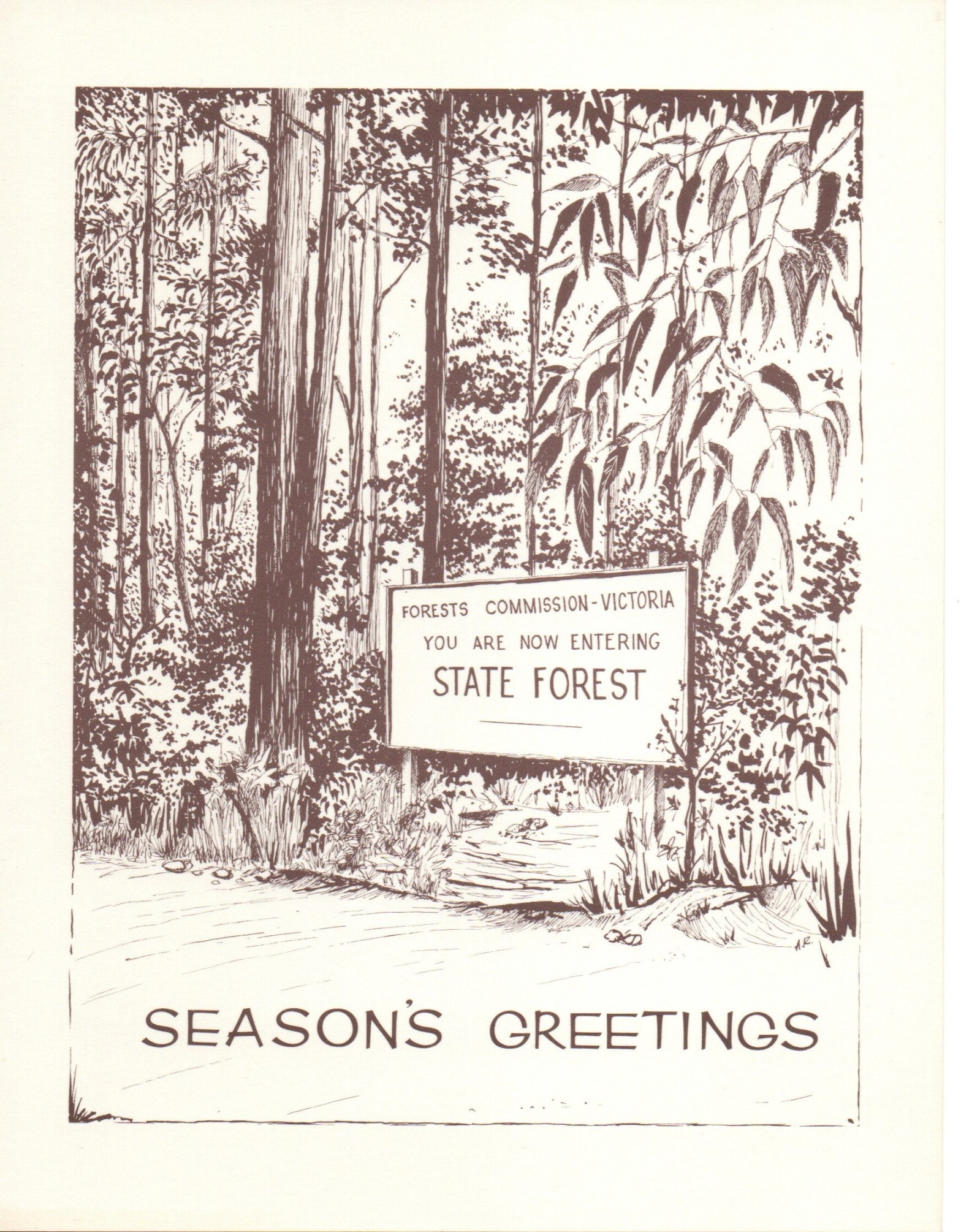
The fantastic sketch on this Christmas card was done in 1961 by Alan Rawady, the Forests Commission’s graphic artist. It was found in a box of old stuff at the Altona museum.
The card was produced at a time when Alf Lawrence was the Chairman with Herb Galbraith and Ben Benallack as Commissioners. It includes the circular “Seal” of the Commission with myrtle beech fronds, which had been in service since the 1920s.
Alan also designed of the iconic “two-tree” logo in the mid-1960s.
Alan had the grand title of Artist and Display Designer and was part of the three-person Publicity Branch with Alan Watts as the manager and George Self as the photographer. They were situated on the third floor of 453-455 Latrobe Street. The building is gone now.
It’s been another busy year on the Victorian Forests and Bushfire Heritage Facebook page.
Once again, I have gathered up the main stories into a free eBook and published them in the national and state libraries so they don’t get lost in the Facebook soup.
But the biggest achievement for 2024 has undoubtedly been photographing and cataloguing items in both the FCRPA Beechworth museum and the DEECA museum at Altona, and working to make them freely available online.
Two self-guided historical walks at Creswick have also been created – one around the VSF school grounds and another near the old sawpit gully nursery.
Please feel free to download and/or share the link to Series Five.
Finton George Gerraty was born on 23 September 1899 at Myrtleford. He entered the Victorian School of Forestry (VSF) at Creswick in 1915 and graduated two years later in 1917.
His postings with the Forests Commission Victoria included District Forester at Orbost in 1920, DFO Gellibrand in 1924 and then DFO Niagaroon (Taggerty District) in 1927.
Later in 1930, Finton was promoted as the Chief Forester at Powelltown, while only a short time later in 1935 he was elevated to the Inspector of Forests for the Central Division based at Healesville. He then moved to a similar role at Berwick in 1937.
Finton somehow found time to study towards a Diploma of Forestry (Victoria) and the topic of his thesis was “The regeneration, silvicultural development and utilisation of Eucalyptus obliqua – messmate stringybark”.
Never office bound, he is said to have personally measured a fallen mountain ash tree near Noojee after the 1939 bushfires at 338 feet and reported that “its top was tantalisingly broken off”.
Finton also took a strong interest in new technology such as the introduction of crawler tractors for logging at Marysville in the late 1930s, as well as the operation of Kurth Kiln at Gembrook to produce charcoal during the war years.
Finton Gerraty was considered by his peers as ambitious, keen, efficient and accurate. But he was sometimes described by his detractors as being a tough forester from the old hard school… whatever that means…
In March 1942, Finton joined the 12th Victorian Battalion of the Volunteer Defence Corps (VDC) with the rank of Captain. And during the latter part of the war, he was seconded to the Department of Army to examine and advise on the timber resources of the Northern Territory and then organise logging, transport and milling.
At the conclusion of the war in 1945, Finton assisted Associated Pulp and Paper Mills (APPM) in Tasmania to prepare a utilisation and roading plan for the company’s pulpwood procurement areas.
Within weeks of the end of the war, the Chairman of the Commission, A. V. Galbraith, outlined his vision for the future, or “Grand Design” as I prefer to call it. Then a quiet revolution began across Victoria’s forests and an epic story which took more than eighty years to unfold where several things were in play.
Undoubtedly, the main social and economic beneficiaries of Galbraith’s Grand Design were small rural settlements like Heyfield, Mansfield, Myrtleford, Bruthen, Orbost, Cann River, Colac, Alexandra and Swifts Creek which grew into thriving communities based upon the timber industry.
These communities became flourishing “Timber Towns” with jobs, decent housing, schools, shops, sporting clubs, public transport and health care. A more secure and safer place for families than the previous itinerant sawmills set deep in the bush, which was characteristic of the earlier period.
From May 1947, Finton was appointed as one of the three Forests Commissioners, and after the death of A V Galbraith in May 1949 he was elevated as Chairman. He then had the main task to implement the Grand Design that Galbraith had previously laid out.
In 1952, Finton travelled to England, Scotland, Norway, Sweden, Germany, Switzerland, Italy, Canada and USA investigating forestry practices and industries, particularly the economics of utilising lower grades of wood. And while he was away, he represented Victoria at the 6th Empire Forestry Conference at Quebec in Canada.
In 1956, the Commission’s Newport seasoning works closed under a controversial financial cloud. A situation made worse because Newport had barely ever been profitable. Newspapers accused the Forests Commission of “juggling the books” to turn a loss into a profit. There were also allegations of unexplained “leakage” of large quantities of valuable timber stocks.
Finton George Gerraty died suddenly of a heart attack at his home on 25 June 1956, right in the middle of the Newport crisis. The State Government was furious about the whole financial fiasco and there were calls for an independent inquiry and appointing an outsider to run the Forests Commission.
It took more than six months for the political and media dust to settle before Alf Lawrence was finally appointed as the replacement Chairman of the Forest Commission in December 1956. A role he occupied until his retirement in July 1969.
Photo: Looking more like mobsters than foresters. A.V .Galbraith, FCV Chairman, Finton George Gerraty, then Inspector of Forests and Herbert FitzRoy OIC Boys Camp at Rubicon. Photo: Allan Layton
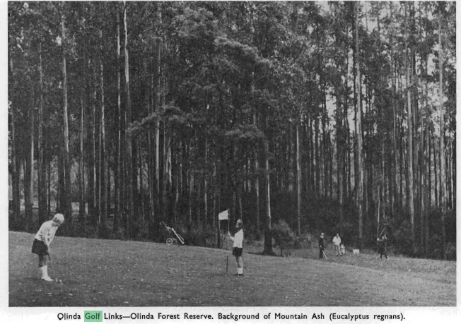
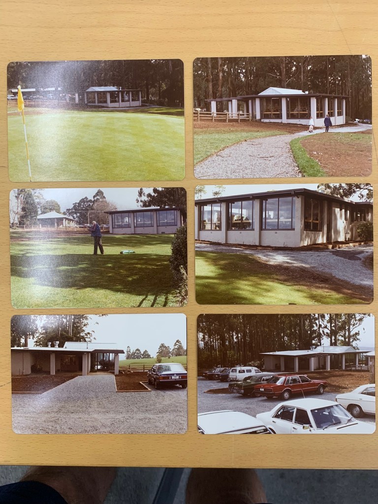
The suggestion of a golf club at Olinda in the Dandenong Ranges began circulating in 1905 and was revived again in 1931 as an idea to celebrate Victoria’s centenary.
The land was identified by the local community as a bushfire menace after the 1926 fires and many claimed that a well-maintained golf course would reduce the threat.
During the subsequent years several unsuccessful attempts were made to establish a golf course despite the amounts of monies raised. The Nicholas family of Burnham Beeches, Sir George Knox and Messrs Eric Leone, E J Gillies, W Brann and A P Dodd were active in public meetings and discussions with the Forests Commission. The Hon Gilbert Chandler also supported the project.
The first 9-hole course, occupying a 70-acre parcel of State forest, was proposed in 1933.
The Olinda golf club formed in 1934 and while some locals opposed the idea, the Forests Commission Victoria (FCV) granted a long-term lease over the State forest.
The course was laid out in 1936 but fell into disuse during WW2.
In January 1948, a licence for a public golf course on Reserved Forest was issued by the Forests Commission. A golf club had already been formed, and its members began preparing a 28-hectare area for the course.
In 1952, the club was revitalised under an affiliation with the Victorian Golf League and Mr A O Wilson was appointed as the manager following voluntary liquidation of original Olinda Golf Club.
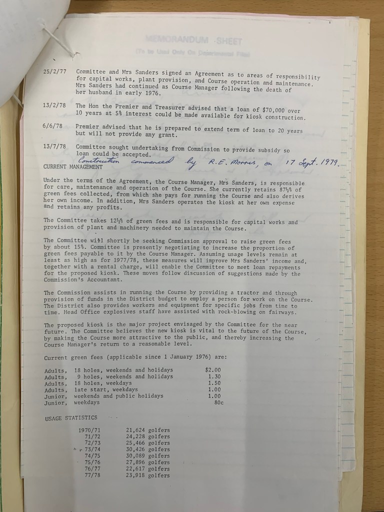
In May 1956 the golf course declared as reserve under Section 56 of Forests Act. A month later in June 1956, a Committee of Management was appointed, with the original members including Mr & Mrs Dodd along with the District Forester, Mr Jim Westcott. The Committee then appointed Mr & Mrs Len Myers as Course “licensees” for operation and maintenance of the Course. A year late in October 1957 regulations were promulgated.
In July 1961, the Committee requested the Forests Commission for provision of a kiosk. In 1966 a temporary kiosk was built. In January 68, new tenants in kiosk, Jim and Pat Sanders, became course “licensees” and were appointed to manage and maintain the course.
From about 1964 onwards, the golf course was set aside as a Special Purposes Reserve and upgraded and extended at considerable expense to the Forests Commission. Pumps and sprinklers were also installed to keep the course green in summer.
After more bushfires in 1968, the Forests Commission entered into a renewed lease with a fledgling Olinda Golf Club.
The extended 18-hole course was opened in April 1970 by the Minister for Forests, Edward Raymond Meagher.
In May 1972 the Olinda Golf Club was given approval by Commission to build a new club house on course. In March 1975, The reserve was reduced to 35 ha with 16 ha added to adjacent Olinda Arboretum.
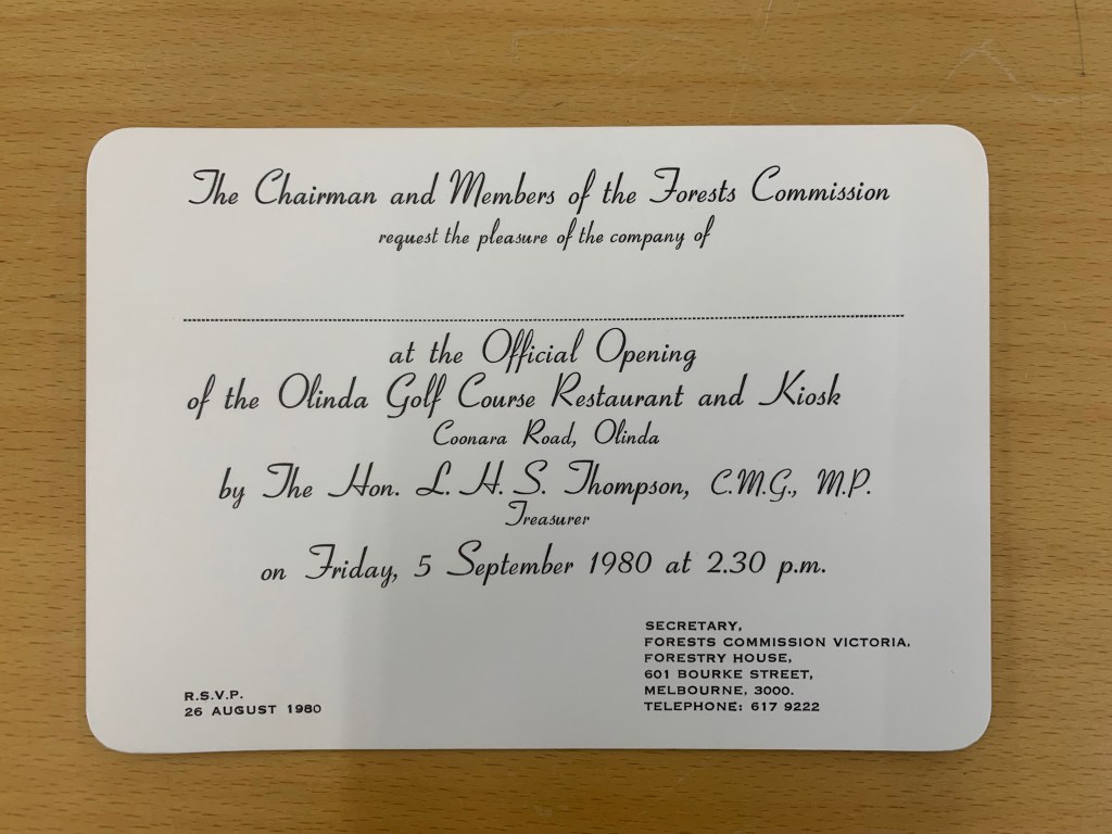
In February 1978, the State Government offered a $70,000 loan to the golf course at 5% interest which enabled it to build much needed facilities and clubrooms including the popular Bide-A-While restaurant which was later opened by Lindsay Thompson in September 1980. An ambitious proposal for a motel was also considered but rejected.
The District Forester from Kallista, Jim Westcott, and later Frank May, sat on the Committee of Management. This was an unusual arrangement. Olinda was the only golf course in Victoria where the Forests Commission took an active role.
The Commission assisted in running the course by providing a tractor and funds in the District budget to employ a person for work on the course. The District also provided crew and equipment for specific jobs from time to time. Head Office explosives staff also assisted with rock-blowing on fairways.
Strategic Firebreak.
In January 1962, there were major bushfires across Melbourne’s outskirts, including the Dandenong Ranges, which killed 33 people and destroyed more than 450 homes. The Olinda township was attacked on three sides and many houses were destroyed and forests burnt. Many people evacuated to the relative safety of the golf course, which was also partially burnt.
The newly established 100-acre National Rhododendron Gardens adjoined the golf course and burned as well. The rhododendron gardens were also on State forest and had been licensed from the Forests Commission in 1960. Most of the mountain ash (Eucalyptus regnans) were killed in the bushfire, and the present trees in the garden and carpark have regrown since that event.
The Forests Commission depot and residence on Chalet Road, occupied by overseer Charlie Chamberlain, was lost when the FCV softwood plantations near Silvan dam exploded in flames.
In the wake of the catastrophic 1962 bushfires there was considerable community outcry. The State Government, with the strong backing of the local MP Bill Borthwick, implemented a long-term buy-back scheme whereby the Forests Commission purchased private land and houses in high fire risk areas, mostly notably on the western face of the Dandenong Ranges.
As part of this planning process, the Dandenong Ranges Fire Prevention Committee (DRFPC) identified the Olinda ridgeline as a critical firebreak and buffer for the town.
Also, after the deadly 1962 bushfires, the DRFPC urged the construction of the nearby Olinda Swimming Pool to act as an emergency fire dam. The 100,000-gallon pool had six fire hydrants to fill CFA and FCV tankers and was located on 5-acres of State forest. The pool was opened by the Minister for Forests, Lindsay Thompson, on 30 December 1964.Furthermore, after a lengthy period of procrastination, community consultation and planning, local Forests Commission crews began replanting the 192 hectares of the old softwood plantation which were burnt below Chalet Road in 1962 with exotic and less-flammable species such as oaks and elms. The area also has a magnificent lookout over the Olinda forest towards Silvan Reservoir and was renamed the R. J. Hamer Arboretum in April 1977.
Importantly, the Olinda Golf Course was strategically positioned on the main ridge. It sat between the R. J. Hamer Arboretum, the swimming pool and the Forests Commission depot in Woolrich Road to the east, and the Olinda Recreation Reserve and the National Rhododendron Gardens to the west. These parcels of public land, all with significant local community use and tourism attraction, had reduced levels of flammable vegetation, and collectively acted as an effective east-west firebreak.
Parks Victoria took over the responsibility for the Olinda golf course in 1989 and issued a new lease, but club membership continued to decline, which was a common pattern among public golf courses across Melbourne. Olinda finally closed in about 2012 and the remaining club members shifted to Emerald.
The State Government announced that the land would not be reinstated as a golf course but set aside for other community uses. The redevelopment of the site has not been without local controversy.
The Olinda pool also closed for a time but reopened after community agitation.
While there are many other golf courses on the edge of small country towns across rural Victoria, which often operate on private land or under a variety of Crown Land leases and occupancy arrangements, the Olinda golf course was a showpiece for the Forests Commission as a unique example of passive fire prevention on State forest, as well as being a valuable asset for the local community.
The 34-hectare Olinda golf course was positioned on a main ridge which adjoined the R. J. Hamer Arboretum and the Forests Commission depot in Woolrich Road to the east. The Olinda Recreation Reserves and the National Rhododendron Gardens were to the west. These parcels of public land collectively acted as a unique east-west strategic firebreak. The Olinda Swimming Pool was also built after the 1962 bushfires as an emergency fire dam. Source: MapShare
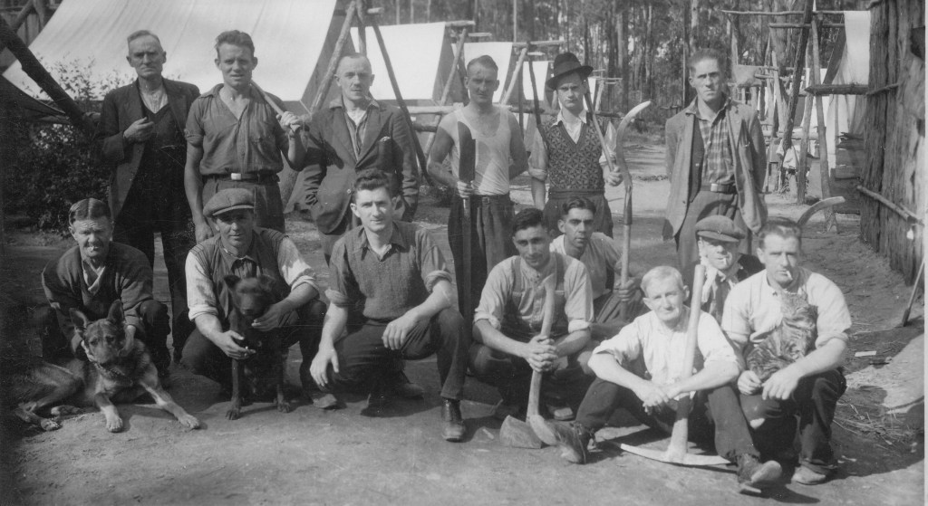
Charles George Pettman began working with the Forests Commission in the early 1930s on an unemployment relief program.
About 30 unemployed men came from Melbourne and beyond to their first camp on the old Princes Highway at Burnt Bridge, which was situated on the Toorloo Arm of Lake Tyers in East Gippsland.
There was a hot meal ready when the men arrived, enough kerosine in lanterns for one night, and their beds were two poles on forked sticks and two chaff bags. Clothing, boots and blankets could be purchased from the Commission while food came from Lakes Entrance. The men were paid on a Friday, but 5/8ths of their pay was sent home to their dependants.
The Forests Commission supervising officer was Freddie Kerr and the crew were engaged for three months for silvicultural works such as ring-barking the overmature trees to release the regrowth. Most of the men had never used axes before and blisters were common, but after 3 months there were some good axemen amongst them. They also fought bushfires in the summer and did fuel reduction burning along firebreaks during the autumn.
At the time, the Forests Commission only had rakes, slashers, axes and knapsacks to fight bushfires. There were very few motor vehicles or spotting towers, so the Commission employed fireguards such as Bill Ah Chow and Charlie Pendergast to patrol the bush on horseback to spot fires.
Because there weren’t many roads, fires started by lightning in the mountains meant a lot of walking. So, in the remote high country they were often left to trickle and the cattlemen kept the Commission office informed.
During the war years, Charlie supervised charcoal burning crews near Nowa Nowa. The wood for the kilns was cut from the old ring-barked trees and the charcoal was bagged and transported by train to Melbourne for use in gas-producer cars.
Charlie also helped build Cosstick’s Weir in the Colquhoun State forest in 1945. The weir was used for fire protection and not to fill steam trains as is a common rumour.
After the war, Charlie remained with the Commission building roads in the Irish waterholes area. The thick scrub was first cut with a hand slasher, the trees grubbed out with hand tools and the logs rolled off the road by hand, until blocks and tackle became available. The arrival of bulldozers and graders as well as an ex-army 4WD White Scout Car for transport made the work much easier.
The Nunnett Road was also built by Charlie to open the area for logging, and he later was given the job to supervise the harvesting contractors.
During his career with the Commission, Charlie fought in many major bushfires including the 1965 blaze which burned for several weeks from Lake Glenmaggie to beyond Bruthen.
He retired from the Commission in 1975 and took a role as a guide with Forestours during the holiday period.
Photograph taken in 1935/36 (Source: D Pettman) : Charles Pettman (back row, extreme left with dog) and FCV Employment Relief crew on the Old Buchan Road
Photograph taken in 1935/36 (Source: D Pettman) : Charles Pettman (first standing row, 3rd from right) at an FCV Employment Relief Camp near Burnt Bridge, Toorloo Arm, Lake Tyers
Photograph taken in 1935/36 (Source: D Pettman) : Charles Pettman (front, 3rd from left) at an FCV Employment Relief Camp near Burnt Bridge, Toorloo Arm, Lake Tyers
Photograph taken in 1935/36 (Source: D Pettman) : Charles Pettman (left) – probably near Burnt Bridge, Toorloo Arm, Lake Tyers.
Military training has always been an important activity on Victoria’s State forests and public lands. Probably the most notable example was the takeover of Wilsons Promontory by the commandos in 1941.
Forests were used for both target aiming and live firing. The prominent Lollipop Tree on Mt Beckworth, west of Ballarat, was used by RAAF bomb aimers during WW2.
Manoeuvres by Army Reserve troops are still common.
Unexploded Ordnance (UXO) occasionally turns up in the bush. It ranges from small rifle shells and casings through to practice hand grenades and larger mortars and rockets.
There are many epic stories of departmental staff encountering dangerous UXOs during the handover of Point Nepean from the Army to become a National Park in the 1980s.
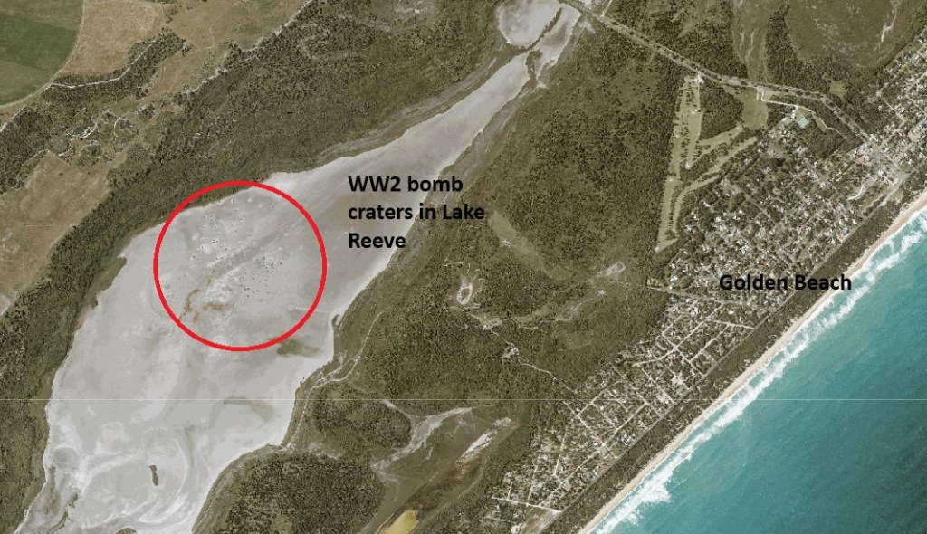
Bomb craters are still visible in the shallow mudflats of Lake Reeve near the 90 Mile Beach and scrub fires in the nearby Dutson bombing range can also be very problematic.
Not surprisingly, UXOs are most likely to be found around existing military bases. The land at Puckapunyal had become severely degraded because of prolonged use by the military and in the early 1970s a major soil stabilisation and revegetation program began. The Soil Conservation Authority took the lead role while the Forests Commission provided trees from its nurseries as well as planting crews.
In May 1989, a group of seven employees were planting trees on the Puckapunyal base near Tehans Hill and lit a small fire to keep warm. But the fire was on top of an old 105mm anti-tank shell buried in the ground which exploded seriously injuring the men, one critically.
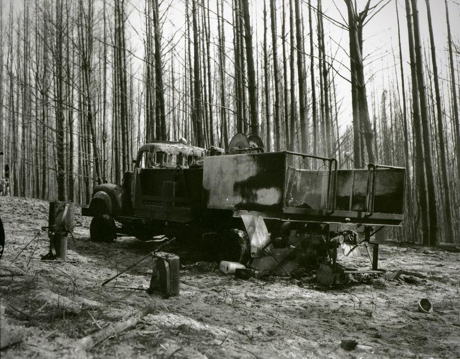
On 5 April 1958, a fire was reported about 5 miles northwest of Wandilo, which is not far from Mt Gambier and the Victorian – South Australian border.
The Bluff firetower reported light smoke at 08.25 am on Saturday morning and by 11.40 am the fire was moving quickly and out of control.
It had been a dry autumn and the fire, which began in a dry swamp of dense t-tree, was fanned by strong winds, quickly spread into a mixture of native forest and pine plantations.
The cause of the fire was never officially determined, although most suspected it had escaped after someone was burning off on private land near an old disused railway line.
By midday the temperature reached 92 degrees Fahrenheit, and the Relative Humidity at Mt Gambier Airport dropped to 29% as a fire storm developed under a 40-mph north westerly wind. The FFDI was 33 (Very High).
As the conditions worsened, the fire began crowning through the pines and throwing spot fires up to 20-30 chains (600 m) ahead of the main front as it crossed Earls Road near the disused Medhurst railway station.
Several trucks with firefighters from the Department of Woods and Forests had been dispatched and they entered an east-west firebreak between two blocks in the pine plantation. The adjoining Pinus radiata and Pinus pinaster stands were about 24 years old and un-pruned.
Around 3.00 pm the firefighting crews were caught unprepared in a junction zone as two flanks of the fire passed over them and then swirled back to join.
Two forestry trucks became bogged in soft sand when trying to evacuate while another damaged a gearbox and could not move, leaving 11 men to take cover in their vehicles.
Eight men died. The youngest was only 16.
– Remo Quaggiato
– Charles Dolling
– Bertram Wilson
– Victor Fensom
– Maurice Treloar
– Francis Burdett
– Walter Pearce
– Bernadus Damhuis
Three remaining men survived with moderate burns. Two sheltered in the cab of one of the trucks and emerged safely after the intensity of the bushfire had subsided even though their vehicle was well alight. One man survived by sheltering in a deep sandy wheel rut and covering his face with his coat.
Another party of men narrowly escaped as they drove their truck to safety pursued by roaring flames. The heat was so intense that the clothing of several of the men on the truck caught fire.
The Mount Gambier fire service received its first indication of the tragedy when it heard an emergency “mayday” call over the two-way radio. Grim-faced crews gathered around heard a dramatic call for “Police, a doctor and a priest.”
The 3300-acre fire was brought under control early the next day.
A public outcry followed, and the inquest found the men had been failed by their equipment, with vehicle fuel lines vaporising in the heat and truck cabins ill-equipped for survival situations. Firefighting tactics and equipment changed after the tragedy.
The Wandilo fire occurred at a time when bushfire behaviour research in Australia was in its infancy and years before methods were available to fire managers to quantitatively assess fire potential.
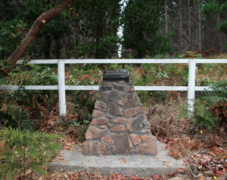
The legendary CSIRO fire scientist, Alan McArthur, published a review of the Wandilo fire later in 1966. It became a benchmark in understanding fire behaviour in pine plantations.
A small memorial marking the site of one of South Australia’s most tragic bushfire disasters sits in the midst of tall radiata pine trees, largely hidden away from public view.