By the time of the formation of an independent Forests Commission in 1918, the area of Victoria’s Reserved forest estate had stabilised at about 4 million acres.
All forest experts and enquiries said this figure was far too low for Victoria’s future timber needs and it was claimed that a minimum of 5.6 million acres of productive and accessible forest were required.
Most of the state’s remaining public land was designated as unalienated Crown land (e.g. Protected forest) and was still subject to sale by the powerful Lands Department.
But there was still strong resistance for more forest reservations by those in government and by those interested in gaining more land for grazing and agriculture, and unfortunately there was general public apathy.
Perhaps foreseeing a threat to the fragile integrity of reserved forest estate in a post war reconstruction period, Hugh MacKay wrote in the 1917-18 annual report –
It is my duty to call attention to the danger which will threaten the existence of many of the most valuable forest reserves on the northern plains during the coming period of repatriation [of soldiers]. Scattered over a wide expanse of country between Horsham and Chiltern, they afford there the only safe supplies available of fencing timber and fuel for future years. They bear in quantity, in addition to other species, grey box and ironbark, two of the most useful and durable of Australian hardwoods and as a source of supply of railway timber alone their permanent retention as forest is essential…
It would be an incredible folly after the period of forest destruction which culminated in the ruin of the Otways, of the Moormbool box forest in the Heathcote district and of the Gippsland red gum forest
Following the end of the War almost 78,000 diggers returned home to Victoria.
Soldier Settlement Schemes were designed to provide some of these returned soldiers with a livelihood. It was also a reward for their service. The patriotic notion of “Yeoman Ideal” and of a “land fit for heroes” resurfaced with a promise of prosperous farms, secure families and thriving rural communities.
The Land Act (1898) gave power to the State government to compulsorily purchase portions of large land holdings and sell or lease that land in smaller parcels for farm development.
Under the Discharged Soldier Settlement Act (1917), Crown land could be made available for settlement but, as it turned out, much of it was purchased, subdivided and resold.
The scheme was first administered by the Victorian Lands Purchase and Administration Board and, from 1918, by the Closer Settlement Board.
Settlements were established in the dryland farming areas of the Mallee, South Gippsland and the Western District, and in the irrigation areas of the north-west along the Murray, central Gippsland near Maffra and Sale, and the Goulburn Valley.
In addition, the British Government passed the Empire Settlement Act in September 1922, which promised 10,000 migrant settlers for Victoria over the next five years.
By 1930, the Victorian Government had acquired 2.5 million acres and about 12,000 returned servicemen had taken up the scheme.
Low interest finance and no repayments for the first 3 years on 36-year purchase leases were introduced for the settlement of discharged soldiers. From 1922 assisted British immigrants were also settled on the land as part of the Closer Settlement schemes.
Few had seen their block of land before they bought it, and only 20% had any farming experience. It was lottery and some soldier settlers were lucky enough to secure a good block. Some farms remained free from the ravages of pests and disease, but none could escape the plunge in farm commodity prices in the 1920s.
By 1926, nearly a quarter of the soldier settlers had walked off their properties. A Royal Commission in 1925 had identified many shortcomings of the schemes especially the marginal land such as the Mallee and recommended against settlement in future.
Perhaps one of most notable returned servicemen who later worked for the Forests Commission was Bill Ah Chow. He attempted to settle with his wife Myrtle at Mossiface near Bruthen and worked the land for three years, but the shoulder injuries he sustained in the war made farming too difficult.
With his extensive knowledge of the local bush, Bill was offered a job by the District Forester, Jim Westcott, as a Fire Guard and famously built Moscow Villa on Bentley Plain in 1942.
Soldier settlement schemes were revisited again after WW2, most notable at Heytesbury in western Victoria.
Bill Ah Chow’s application in 1923 for two small allotments of land under the Soldier Settlement Scheme in the Parish of Bumberrah at Mossiface. PROV: VPRS 5714/P0000, 664/86
Handbook issued by the New Settlers League of Australia, 1925. Source: PROV.
“One of the grandest public estates in the Colony”. Conservator George Perrin – 1894.
The European settlement of the Red Gum forests along the Murray River, like many other places, followed the initial routes of early explorers such as Hume and Hovell, Charles Sturt and Major Mitchell.
Despite attempts by the NSW Governor to restrict land settlement to 19 counties around Sydney, the squatters soon established pastoral runs.
In December 1840, Edward Curr, a Tasmanian merchant and landowner, acquired a sheep run near Heathcote. With the help of his sons, Edward and Thomas, they took up several additional runs.
To overcome the problem of summer grass they selected a tract of country on the south side of the Murray River known as Moira. The forests were flooded for several months during the winter and spring but then flourished over summer with excellent sheep fodder.
Red Gum seedlings are sensitive to fire and the openness of the forests may have been explained by indigenous burning.
The Curr’s were soon joined by other pastoralists, and by the mid-1840s the Red Gum forests at Barmah were surrounded by other squatters.
Efforts by Governor Gipps in 1844 to tax the squatters were strongly opposed and eventually thwarted in both Sydney and the Colonial office in London. The pastoralists were then left in control of one of the richest grazing and forest assets of the Colony at ridiculously low prices.
A one-square-mile, or 640-acre, “Presumptive Right” was granted to Roderick McDonell in February 1854 to surround his small farm, slab hut, stockyards and stable at Yielima, and remains a legacy of the pastoral era.
The discovery of gold at Bendigo and Ballarat in 1851 increased the fortunes of the grazier’s by supplying the miners.
A railway line was extended beyond Bendigo to Echuca in 1863 and sleeper cutters fanned out across the nearby Red Gum forests. Collier and Barry were the main contractors, but they closed the mill when the railway was completed in 1864.
With the new railway line to Melbourne, Echuca developed into a thriving inland-port, and by mid-1865 a fleet of 26 paddle steamers were working the Murray River plying the profitable wool trade.
In the 1860s, durable species like Red Gum was in big demand for the construction of wharf piers and for export to India for railway sleepers and construction timber. As Bendigo’s quartz mines began to go deeper and deeper, red gum was found to be an excellent timber for the slabbing of shafts.
The later expansion of Victoria’s railways under the notorious “Octopus Acts” of 1880 and 1884, once again fuelled the demand for sleepers, and at least six millers were at work in the Red Gum forests.
Interestingly, the sleepers were cut in spot mills rather than hewn with axes, which was a very wasteful practice, and one which the Forest Conservator, George Perrin, had continually fought the railways over.
Some of the first mills were established near the Goulburn River junction and Collier and Barry in 1863 and James Macintosh, a migrant from Elgin in Scotland in partnership with Amos and Taylor. After a flood in 1867, Macintosh bought out his partners and shifted his Goulburn Junction mill to Echuca East in 1868. Five or six other smaller mills also located there.
The competition between sawmillers was unscrupulous and cutthroat. It was alleged that in the mad scramble to access the best timber, millers attempted to exclude newcomers by sending gangs of men to new sawmill sites, where they would fall and brand all the available trees, regardless of their condition or size, and make no attempt to remove them.
As the timber trade in the Barmah forest expanded, the mills of James Mackintosh and his competitors in Echuca evolved into vast and complex industries. In 1873, Mackintosh’s Echuca East works consisted of sawmills, offices, stables, a blacksmith shop, Mr Macintosh’s substantial home, and houses for his employees. A tramway had also been laid down from the river to the mill.
James Macintosh was not only a pioneer entrepreneur of the red gum trade, he was also, a prominent local citizen, a Borough Councillor and Mayor, as well as an elder of the Presbyterian Church. The unusual memorial archway in Echuca made of Red Gum was erected by Macintosh to honour the visit of the Colonial Governor, Sir Henry Brougham Loch, in 1884.
As early in 1869, Crown land bailiff, Henry Stephenson, warned his superiors of the impact of over cutting of the forests. He pointed to magnificent stands of tall and straight trees which still remained. He strongly advocated for the creation of the Barmah Timber Reserve and in July 1869 some 19,600 acres was proclaimed.
Just one year after Stephenson’s report, the newly appointed “Overseer of Forests and Crown Land Bailiff, William Ferguson, wrote of the riches of the River Red Gum reserves and pointed out the threats to his senior officers in Melbourne. These included the Assistant Commissioner of Crown Lands and Survey Clement Hodgkinson, and Baron Von Mueller.
In many places he counted 80 to 100 trees per acre, upwards of 60 feet tall and 18 to 20 inches in diameter. Great preparations, he warned his superiors, were being made for hewing down the best timber and sending it to India. Already huts had been erected, and preparations were being made to bring portable steam engines into the forest.
Ferguson concluded that:
“with proper care and protection these forests on the Murray may be made available for generations as they are magnificent nurseries for young trees which are now being so ruthlessly destroyed.”
Ferguson’s advice was acted upon with the proclamation of the Yielima State Forest in July 1870, which brought the total area reserved to roughly 45,000 acres. The Lands Department to ceded to the request because the Barmah forest was flood prone and not suitable for alienation into farmland.
Timber harvesting was permitted in the State forests but mechanisms to regulate it was full of loopholes and there were few foresters on-the-ground to enforce them.
Clement Hodgkinson then attempted to regulate the sawmillers in 1874 by restricting cutting areas to 5000 acres, to give the forest a chance to recover. But the opposition from millers, some rural politicians and the local press was too strong, so the plan was shelved.
A local Forest Board was proposed for the Red Gum by Premier James McCulloch, river boat owner and later sawmiller. Legislation to create the Boards had been enacted in 1871 and was intended to give Boards the power to grant licences, to manage and control Timber Reserves, to appoint bailiffs, to conduct prosecutions, give penalties and collect moneys.
But many observers felt that the power and local influence of sawmillers, particularly James Mackintosh, made it unwise to establish a local board for the Red Gum forests. A change of government in 1877 scuttled the idea altogether.
In its almost unregulated state, the Red Gum trade continued to expand. In 1875, it was estimated that seven sawmillers in the Echuca district alone employed almost 400 men and cut almost 400,000 superficial feet of timber from 1000 logs per week.
The annual winter flooding of the forests impacted the pattern of timber harvesting and transport. When the forest dried out in spring, logs were cut and taken to the banks of the Murray River by bullock or horse teams and waited to be loaded onto barges and towed or floated downstream to sawmills. Some of the logs were stockpiled on the banks of the river near Echuca.
In 1873, Mackintosh owned two steamers, the Enterprise and the Julia. It’s said that he was the first sawmiller to use river transport to bring the logs to a mill with log barges which could carry 40 tons or about 30,000 super feet.
Barges were either insiders or outsiders. Logs were either placed inside the barge or chained below the out-riggers hanging across the gunwales.
The famous Paddle Steamer, Hero, later to be owned and operated by the Forests Commission during WW2 to solve Victoria’s fuelwood crisis, was launched from Mackintosh’s sawmill in September 1874.
Steam engines were also used to operate small portable spot mills in the bush to cut logs from the late 1800s until the 1940s.
In November 1877, in an effort to regulate cutting and conserve young forest regrowth, the Red Gum trade took another hit when the Minister for Trade and Customs Peter Lalor (of Eureka Stockade fame) announced a duty of 10 shillings per 100 super feet would be levied on timber exported to other states and overseas. Sawmillers and contractors protested loudly as their markets collapsed overnight.
Alexander Robert Wallis, Secretary of Agriculture and member of the Central Forest Board, was sent to investigate the complaints. His scathing report from 20 July 1878 justified the Government’s stance as he witnessed for himself the forest devastation. He estimated that only 4 to 6 years of timber remained, but that careful controls could ensure that the forests were not exhausted.
Unsurprisingly, the locals strongly disagreed with Wallis’ assessment. In August 1878, the local MP, Duncan Gillis, claimed that nearly 1,000 people were unemployed as a direct result of the duty.
Sawmillers and mill workers reacted swiftly by organising protest meetings against the Government and deputations were made directly to the Premier, Graham Berry.
The Government capitulated and suspended the duty for a year from August 1878. But they required millers to enter into bonds to pay the duty if the legislation was reimposed. A long period of uncertainty followed. The duty was suspended twice more, before being finally repealed in August 1881.
The economic depression of the early 1890s, together with the crippling state tariffs, forced James Mackintosh into liquidation. Other sawmillers either amalgamated or closed.
The industry had been brought to a standstill. Where 14 mills had been hard pressed in 1877 to cope with demand for sleepers, only 3 mills remained by 1881.
The Red Gum trade had seen its greatest days.
However, Richard James Evans, who came to Australia from Wales, then founded a sawmilling firm in Echuca in 1899. The mill was moved to the present site near the wharf and current historic precinct in 1923. The Evans Bros. also owned and operated the paddle steamers Edwards and Murrumbidgee, which were used to transport of logs until 1956. Three “outrigger” barges were named Alison, Impulse and Clyde while two “insider” barges were named Ada and Whaler.
In 1892, it was then pointed out to the Colonial Government that while Victoria granted the right to cut Red Gum at nominal fees, across the River in New South Wales a royalty of 12/6 per 1,000 superficial feet was charged.
Under this arrangement a sawmill in Echuca obtained 1,600 logs at Yielima for the payment of 31 pounds while the same number of logs obtained from across the river in NSW would have generated a royalty of 700 pounds.
To prevent excessive cutting of the Victorian Red Gum, the State Government was forced to follow suit, and in 1892 a royalty of 5 shillings per 1,000 super feet was introduced.
One of the only other active measures for maintaining the Forest was the thinning of 15,000 acres by unemployed workers in 1892, under the direction of the Conservator of Forests, George Perrin.
The Royal Commission on State Forests and Timber Reserve reported critically in 1899 on the state and management of the Barmah and Gunbower forests.
The Royal Commissioners also noted that the River Red Gum forests were under the supervision of only one forester, who was stationed near Barmah. His duties were to patrol the reserve from end to end (a distance of about 70 miles); measure logs for the sawmills and assess royalty; and supervise the sleeper hewers, who were at work along the course of the Goulbum River. Grazing in the forest also received their critical concern, which echoed Perrin’s earlier complaints.
Following the formation of the State Forest Department in 1907, and later the Forests Commission Victoria in 1919, foresters attempted to put controls on the previously haphazard and wasteful cutting of timber.
The Commission was able to put greater focus on producing a sustainable level of harvest of sawlogs and sleepers, better silviculture to regenerate and thin the forest, regulating flooding, better licensing of grazing and apiary, building roads and controlling bushfires.
Rather than the previous unregulated arrangement of “sawmiller selection”, the bush was assessed by an authorised forest officer and individual trees blazed on the trunk and given a “toe brand” at the base with a hammer featuring a crown and an identifying number before being felled. Cut logs and sleepers were also branded by the local forester and measurements recorded for the payment of royalties.
Priority was given to producing mill logs from the main trunk. The head and spreading branches, as well as inferior shaped trees, were then cut for sleepers, strainers and fence posts.
Sleepers were first cut into nine-foot lengths then split into billets which were squared with a broad axe and adze. Tall and straight trees produced by thinning were used for posts, piles and poles. Firewood and wood for charcoal was cut from the residue.
From 1945 onwards, the availability of ex-army blitz trucks and tracked diesel tractors to load logs progressively replaced the paddle steamers on the river.
From about 1950, petrol chainsaws and swing saws increased the speed and output of cutting.
Following deliberations of the Land Conservation Council, the Barmah State Park was proclaimed in 1987 which continued to permit timber harvesting and cattle grazing. It was later legislated as the Barmah National Park in 2010.
Source: Charles Fahey (1988). Barmah Forest. A history. CFL Historic Places Branch
From Fahey (1988). The 1800s reservations that foresters argued for are similar in shape and size to the Barmah National Park we see today.
Timbergetters with hand axes and forestry inspector with sawn felled River Red Gum along the Murray River, early 1900’s. Scan of B&W print from album. marked SC3372
Steam spot sawmill. Photo: Barmah Forest Heritage and Education Centre at Nathalia.
George” – Ruston & Hornsby engine owned by the Evans Bros Sawmill at Echuca, bringing a log into the mill. Source: Moulds 1990.Murray Pine Logs at Evans Bros Sawmill on Murray Esplanade opposite the Bridge Hotel [ Sourced from Barmah Chronicles by G M Hibbins, Photo from Evans Family CollectionMany other Red Gum sawmills were spread along both sides of the Murray River. This one is at Koondrook c 1900.
A large chunk of the Otways State forest between Apollo Bay and Hordern Vale was the focus of a bitter dispute in the early 1920s.
It was only saved from clearing and sale for agriculture by the determined efforts of foresters, sawmillers, the media and the community.
The land is now part of the Great Otway National Park.
Early last century State forests were still commonly regarded by the general public, and by most of their parliamentary representatives, as inexhaustible “Wastelands of the Crown” and ready for disposal via alienation into freehold property for the purposes of agricultural settlement.
The Lands Department was a dominant government organisation with alleged political affiliations to vested landholder and pastoral interests inside the Parliament.
The sale of Crown land was also a major source of revenue for the State Government.
The Forest Service on the other hand was the poor cousin and beleaguered foresters like George Perrin constantly struggled to combat the political manoeuvring to release more of Victoria’s State forests for agriculture.
Importantly, large sections of the Otway Ranges had been unsuccessfully cleared for agriculture in the 1890s and the loss of productive forests and waste of timber had been a subject of the 1897-1901 Royal Commission.
The Forests Commission Victoria was created in 1919 and saw its mission to increase Otway forest reserves by “reclothing with the timber of which it had been denuded” and jealously guarded the thousands of hectares it had acquired from bankrupt, abandoned and voluntary sale blocks.
Local municipalities were not big supporters of State forests or reforestation because the land didn’t generate rate revenue.
In the 1920s the Lands Department sought to acquire access to the Hordern Vale forest with a view to converting it to farmlands.
Ironically, the area proposed for clearing was surrounded by 90,000 acres of abandoned farmland from previous settlement attempts in the 1890s.
Despite being required under the legislation, the Lands Minister, David Oman, stated in 1921 that he would no longer even consult with the Forests Commission over land settlement.
The first test case came in June 1923 when Oman announced a proposal to excise 26,850 acres (subsequently reduced to 12,000 acres) of State forests for farming in the densely forested Otway Ranges west of Apollo Bay.
The Forests Commission and the Minister for Forests refused to hand the area over to the Lands Department.
Political agitation to support the Forests Commission’s opposition to the scheme was swift.
In November 1923, deputations from the Australian Natives Association (ANA), the Australian Forests League (AFL), the Hardwood Miller’s Association and the Australian Women’s National League implored the Minister for Forests, Sir Alexander Peacock, to prevent the proposed excisions. They all pointed to earlier futile attempts at farming in the 1890s and suggested some forests were best left unsettled.
Sawmillers pointed to the substantial reductions in employment, income and royalties that the clearing of a sustainable forest industry would cause.
Local Apollo Bay interests pushed the settlement scheme, while the Geelong Timber Merchants emerged as a powerful pro-conservation lobby.
The Melbourne Press, led by the Argus, Australasian, and the Age thundered that the scheme was deeply flawed and lacked due process.
The revival of the idea that forests influenced climate and rainfall was particularly notable during this dispute. The need for water supply schemes for Colac, Camperdown, Terang, Warrnambool and, eventually, Geelong led to the expulsion of farmers from the heads of Arkins Creek, the Gellibrand River and the West Barwon River in the period 1910 to 1960.
In June 1925, after nearly two years of heated exchange, and in the face of so much opposition, the Premier John Allan and State Cabinet finally rejected the proposal and shelved the scheme.
But one major casualty was the resignation in December 1925 of the first Chairman of the Forests Commission, Owen Jones, who moved to New Zealand and bitterly attacked the Victorian State Parliament’s neglect of forestry from afar.
The furore over Jones’ resignation together with the proposed amendments by Albert Lind to the Forest Act to, in effect, turn the clock back and allow the Governor-in-Council to excise land permanently from any Reserved Forest became a major issue in the metropolitan press with numerous articles, editorials and letters.
The Argus documented the long history of political interference in Victorian forestry and noted that the Parliament’s traditional “passive resistance” to forest reservation had shifted to one of “positive hostility”.
The Forests Commission’s 1924-25 annual report once again highlighted the constant pressure, backed by the influence of selfishly interested parties who do not hesitate to nibble still more of the forests away. But it also commented on its small but significant victory.
This adverse influence culminated during the year in a determined effort to alienate from the Otways an area which would virtually have meant the extinction of this famous forest. After a stern fight the interest of the forest won the day, and for the time being, at least, the Otway forest is saved.
But the political agitation to clear and sell the forests in the Otway Ranges wasn’t over yet and bubbled up from time-to-time over the ensuing decades.
The last great clearing of the western Otways was from 1956 to 1970 under the Heytesbury settlement scheme centred on Simpson. About 43,000 ha of forest vanished in this operation. Gellibrand sawmillers asked for the opportunity to cut through the forest ahead of the bulldozers dragging the clearing chains and balls but were told it was none of their affair and the trees were pulled over, piled into windrows and burnt.
Legg (2016). “Political Agitation for Forest Conservation: Victoria, 1860–1960”. International Review of Environmental History.
Map showing 90,000 acres of abandoned settlement land from the 1890s (solid black), Reserved forest (hatched) and the proposed 12000 acres that David Oman wished to alienate and sell (between the dotted lines). Prepared by Hugh Mackay – FCV Commissioner. Source: The Gum Tree. Vol 8, No 31, 1924.
The large area of forest (now part of Great Otway National Park) between Hordern Vale and Apollo Bay was earmarked for clearing by the Lands Department in 1923. Fierce opposition by the Forests Commission and others blocked the move. The Chairman of the Forests Commission Owen Jones resigned. Source: Google maps.
Clearing for agriculture was actively promoted by the State Government through the Lands Department. The fledgling Forests Commission tried to preserve as much productive State forest as possible. This photo is from a small album of the Otways forests produced by the FCV in the early 1920s, no doubt to block the proposal. Source: Public Record Office.
Charles Edward Lane-Poole was born in England in 1885 into an intellectual and widely travelled family. He began studying engineering in Dublin but lost his left hand in a shooting accident when he was 19, and felt he could not continue as an engineer so turned to study forestry at the prestigious National Forestry School in France at Nancy, graduating in 1906.
At the time, the British Empire was parading its prestige, power and influence across the world and its distant dominions. The Colonial Office functioned as a central recruitment and employment agency that sent foresters to India and the colonies where they were appointed to positions by the authorities of the various territories.
Lane-Poole was first placed to Transvaal in Africa in 1906 and later to Sierra Leone in November 1910. Palm oil was the main export and there were some trial plantings of rubber, but it was a small, backwater posting, with little trade and an unhealthy climate on the “Fever Coast”.
Lane-Poole left Sierra Leone in 1916 to take up a new appointment as Conservator of Forests in Western Australia.
He applied for the Chairmanship of the Forests Commission Victoria in 1919 when it was first formed. However, the English forester, Owen Jones, was subsequently appointed and Lane-Poole was offered a role as one of the Commissioners, but he turned it down to remain in WA.
Lane-Poole then had a major falling-out with the State Government in WA over forest policy and offered his resignation in July 1921. The Premier, James Mitchell, was not reluctant to accept it.
Lane-Poole spent the next three years surveying the Papua and New Guinea forests, from the lowlands to the highlands, on behalf of the Federal Government.
In 1924, the Commonwealth Government took a positive step towards involvement in forestry with the appointment of Lane-Poole as its Forestry Adviser, ironically on the recommendation of Western Australian Senator George Pearce.
Royal Commission on the Constitution – 1927.
In August 1927, a Royal Commission was established to examine the powers of the Commonwealth under the Constitution which had operated since Federation in 1901.
Forests and bushfires were a state responsibility but there had been positive moves for greater cooperation with the development of a national forest policy following the first interstate forestry conference in Sydney in 1911.
Lane-Poole held strong views on many things and was one of the first to give a statement at the Royal Commission. He pointed to the unsatisfactory area reserved for forestry purposes which was less than half of what was needed to meet national timber requirements. The 1920 Premiers Conference in Hobart had adopted a goal of 24,500,000 acres of reserved forest across the nation based on the estimates provided by Lane-Poole. He also highlighted a critical shortage of softwoods, which were being made up by expensive imports.
Lane-Poole also wanted to centralise power with the Federal Government to reserve and control an expanded national forest estate, and to eliminate political interference by State Parliaments and Ministers.
He possibly had a good point, but Lane-Poole clearly had trouble building relationships and was openly critical of the management of native forests by the states, which didn’t win him any friends.
His assertion that there were only ten trained foresters in Australia caused great offence to those running the States’ forest services, particularly in Victoria which had been operating the Forestry School at Creswick since 1910.
The Royal Commission closed in 1929 without making any firm recommendations about the control of forests.
Forestry & Timber Bureau.
However, as part of his earlier recommendations to the Federal Government on forest policy in 1924, Lane-Poole drew up a plan for a Forestry Bureau with five branches to:
Advise on forestry matters in Commonwealth territories such as Canberra, Northern Territory, Papua New Guinea and Norfolk Island.
Provide a financial and professional link between the Commonwealth and States.
Improve professional training for foresters at a new Australian Forestry School.
Build a research centre to investigate silvicultural and management problems. In 1933, the legendary Max Jacobs was appointed a research officer and carried out an investigation into timber supplies and the eucalypts of the Northern Territory.
Create a forest products laboratory. The CSIR was established in 1928. This later became the Division of Forest Products within the CSIRO.
Collecting and distributing forestry information including the publication of reports and bulletins.
It took until 1930 for the legislation to pass and Lane-Poole headed the Bureau from its inception until 1944.
Lane-Poole later led the Commonwealth Government’s involvement in forestry the Empire Forestry Conference held in Australia and New Zealand in 1928, then throughout the Great Depression of the 1930s and WWII, but he never had adequate funds or staff.
He was called as an expert witness to the Stretton Royal Commission into the 1939 bushfires and clashed with A.V. Galbraith.
The end of the war, and Lane-Poole’s retirement, prompted a review of the Federal Bureau’s powers and functions. The value of information-gathering and planning functions of Commonwealth Timber Control during the war had convinced the government that they should be continued in peace time. A rebadged Forestry and Timber Bureau operated, in cooperation with the states, from 1946 onwards with a range of new functions.
Australian Forestry School (AFS).
A national forestry school had been supported at successive interstate forestry conferences since 1911. It was announced by the Prime Minister, Stanley Bruce, in May 1925 and was initially located at Adelaide University, with Norman William Jolly as Professor.
The Australian Forestry School (AFS) provided two years of additional study for students who had already completed two years in their state universities and was based upon the model of the French Forestry school at Nancy where Lane-Poole had studied. It was not associated with any established university and therefore could not confer degrees. Students qualified with a Diploma in Forestry from the AFS and a BSc from their home universities.
The Australian Forestry School moved from its temporary home in Adelaide to Canberra in 1927 and Lane-Poole was appointed acting Principal at the Yarralumla campus which he had long been a zealous crusader for.
The state forest services were expected to nominate a steady flow of students, provide them with fully funded cadetships, and employ them once they graduated. But the number of students sent by the states never met expectations, in part due to the Depression, and the Canberra school was often threatened with closure.
Victoria initially sent Alf Lawrence and Charlie Venville in 1926 to attend their first year of study at Adelaide. Ben Benallack and Reginald Torbet attended Canberra from 1928 to 1931, and John Barling and Frank Incoll followed between 1930 and 1931.
Alf Lawrence later travelled to Oxford in 1934-35 to study for a Diploma of Forestry at the Imperial Forestry Institute on the prestigious Russell Grimwade Prize. Returning from England he was one of the most highly qualified foresters in the country.
Lane-Poole remained adamant that the newly established forestry school in Canberra should take over all responsibility for training of Australia’s professional staff and pressed Victoria to close the School of Forestry (VSF) at Creswick.
While other states cautiously relinquished their fledgling forestry schools, the Chairman of the Victorian Forests Commission, A.V. Galbraith, refused to close Creswick. This rejection was in part due to the acrimonious dispute with Lane-Poole, over his allegations of lower professional standards of Victorian foresters.
The prickly relationship soured irretrievably when Lane-Poole wrote to the Argus newspaper on 14 December 1929, slurring Victorian forestry training by suggesting that Creswick was a “woodsman” school rather than a legitimate tertiary institution.
With the support of Melbourne University Professor, Alfred James Ewart, Victoria abandoned the fraught arrangements with Canberra and reverted all its training back to the School of Forestry at Creswick.
Victoria then chose to go its own way and forged strong and lasting academic relationships between Creswick and the University of Melbourne.
And that is why there are three forestry institutions in Australia, rather than one.
The bitter split also created a rift within the Institute of Foresters of Australia (IFA), which was only formed in 1935, because of its refusal to grant full membership to foresters holding only the Victorian Diploma. This petty dispute took many years to heal and undoubtedly proved a major setback to the advancement of professional forestry in Australia.
Lane-Poole held both roles as Head of the Federal Forestry Bureau and Principal of the Forestry School at Canberra until the end of 1944.
After Lane-Poole’s retirement, enrolments at Canberra’s beleaguered Forestry School rapidly increased and flourished under the new direction of Maxwell Ralph Jacobs.
However, the Yarralumla campus eventually closed at the end of 1964 with the opening of the Department of Forestry at the Australian National University (ANU) which developed a four-year Bachelor of Science in Forestry degree and postgraduate research degrees.
Summary.
A picture emerges of Lane-Poole as an energetic, committed and sometimes controversial forester. His overzealous principles, abrasive manner and intolerance of his state counterparts regularly brought him into conflict with employers and colleagues.
His temper and contempt for foresters without his level of professional training, together with his lack of political acumen marred his career.
However, Lane-Poole’s persistence in the face of great difficulties was remarkable, his unquestionable commitment to the advancement of scientific forestry, training and conservation ensures his rightful place in the history of Australian forestry.
Source: Leslie Thornley Carron (1985), A History of Forestry in Australia. ANU press.
Following Federation in 1901, the States retained control of forests within their borders.
But within a decade, the heads of the various State forestry authorities were expressing interest in developing national policies and were given political approval and encouragement to meet and discuss them.
The first of what were to become regular interstate forestry conferences was held in Sydney in 1911. It was attended by New South Wales, Victoria, South Australia and Queensland along with the Government Botanist of Tasmania.
The Conservator, Hugh Robert Mackay, represented the Victorian State Forest Department. Resolutions covered a range of recurring themes, and he said in the 1911-12 annual report.
In November of last year an Interstate Conference on Australian forestry was held in Sydney, all the States being represented except Western Australia.
In addition to useful discussions on matters of forest work and management in detail, resolutions were passed calling the attention of the State Governments to the following important subjects :—
The necessity of laws in all States of the Commonwealth for the conservation, maintenance, and planting of forests, together with the creation of permanent and inalienable reserves, controlled by a permanent authority with adequate powers.
The foundation of a well-equipped forest school in the Commonwealth for the thorough training of students in forestry.
The necessity of establishing plantations of trees of commercial value on large areas of waste land in the several States.
The creation of an Australian association for the advancement of forestry, with the object of inducing the general public to take a deeper interest in forests and tree-planting.
The necessity of concerted action in the establishment of coniferous plantations and in the maintenance of natural coniferous forests, in view of the approaching shortage in the world’s supplies of pine and fir.
The inadequacy in all the States of legislation for the protection of forests from the ravages of fire.
The preservation under forest law and strict control of forests on mountain watersheds, in view of their important influence on streamflow and water supply.
The second Forestry Conference was held in Melbourne and Creswick in 1912 with Mackay as the host. Representatives from the Dominion of New Zealand also attended. Mackay painted a depressing picture depleting areas of forests and of the ongoing neglect by Government. He recommended that each state reserve upwards of 10% of its area for forestry purposes.
The 1912 conference also recommended a program of action to establish uniformity in nomenclature of indigenous tree species. The establishment of the Australian Forestry League was also supported (item number 4 from 1911).
At the fourth conference in Perth in 1917, the visionary Commissioner for New South Wales, Norman Jolly, estimated that Australia would need 25 million acres of forest producing 10,000 million super feet per year for an eventual population of 25 million people.
The next (fifth) interstate Forestry Conference in Hobart in 1920 coincided with Australia’s first Premiers Conference that had “forest” matters on the agenda. The meeting concluded that 24.5 million acres nationally should be permanently reserved as forest to secure timber supplies. The Victorian component was to be 5.6 million acres.
The interstate forestry conferences continued until 1924 but were eventually replaced with broader Empire Forestry Conferences.
The first in a series of Empire Forestry Conferences commenced in 1920 and the third was held in Australia and New Zealand in 1928.
The 1928 conference, among other things, helped focus attention on the need for the establishment of more secure forest reserves. The Forests Commission was able to report.
Total area of Victoria = 56,246,000 acres (approx.).
Total area of agricultural and other non-forested lands = 42,259,000 acres (approx.).
Total area under forest (exclusive of 1,920,000 acres of Mallee scrub) = 13,987,000 acres (approx.).
Total area of reserved forest desirable as a margin of safety to meet the requirements of a growing population was 5,650,000 acres.
Despite a small nett gain of only 181,417 acres since the formation of the Forests Commission 1919, by 1926, the total area of Victoria’s forest reserves was 4,330,452 acres, (not including the vested MMBW water catchments) leaving the State approximately 1.3 million acres short of the agreed 1920 Commonwealth target.
But more importantly, a considerable proportion of the area of Reserved Forest was of little or no value for timber production, being native bush that was too steep, too dry, inaccessible or with poor soil quality. It was mainly reserved because it wasn’t suitable for agriculture and sale by the Lands Department.
Ever since its appointment in 1919, the Commission had drawn attention to this deficiency and urged the Minister and State Government to remedy it, but on every occasion, it was faced with strenuous protest and opposition from selfishly interested parties.
Efforts were also continually made to reduce and alienate the existing forest reserves for settlement.
The following figures show the slight gain of area of State forest and Timber Reserves from when the Commission took control in 1919 compared with the position in 1926.
Ref: Empire Forestry Conference (1928). Handbook of Forestry in Victoria.
This photo is significant. It’s the delegates to 1920 Forestry Conference in Hobart with the new FCV Chairman Owen Jones sitting on far left and Hugh MacKay sitting second from the right. Hugh Robert MacKay was the first Conservator of Forests. Previously a Senior Inspector, he had been Secretary to the Royal Commission of 1897-1901. Charles Lane-Poole is standing third from the right. Source: A History of Innovation – eighty-five years of research and development at Forestry Tasmania. (2008) https://libraries.tas.gov.au/Digital/au-7-0095-01439_1
The following figures show the slight gain of area of State forest and Timber Reserves from when the Commission took control in 1919 compared with the position six years later in 1926.
It was primarily a small band of foresters that fought hard behind the scenes to save Victoria’s remaining native forests from settlement and clearing and they were often publicly criticised as opponents of development.
The foresters maintained a low public profile, partly because they often worked within the Public Service which forced them to remain anonymous and impartial. They chose instead to express their views internally within the corridors and meeting rooms of their departments and not engage in fractious public debates.
Even after the formation of the independent Forests Commission Victoria (FCV) in 1919, the powerful Lands Department continued to sell valuable forested Crown land and the foresters remained frustrated at the lack of progress of forest reservation, adoption of sound forestry principles and forest conservation.
The Australian Forestry League (AFL) was proposed at the first Interstate Forestry Conference held at Sydney in 1911 and officially formed at the following meeting in Melbourne in 1912. Membership included several prominent foresters such as the Victorian Conservator, Hugh Robert Mackay, along with some influential Melbourne businessmen and scientists.
The inaugural President was notable botanist, Professor Alfred James Ewart from Melbourne University, who also oversaw the curriculum at the Victorian School of Forestry.
The League included other big names like forestry benefactor, industrialist and philanthropist Sir Russell Grimwade.
Undoubtedly, the patronage of the powerful Australian Natives Association (ANA), which was formed in Melbourne in 1871, gave the Forest League much of its political influence.
The League was able to publicly advocate for the forest conservation and the promotion of “a forest conscience” which became a fashionable, and enduring, appeal associated with the organisation.
The League’s 1917 constitution called for “the advancement of educational and legislative measures and the encouragement of individual effort tending to ensure the maintenance, extension and renewal of the forests of Australia”.
For almost four decades from 1917 to 1955 the League produced the very conservative, but very informative, Gum Tree magazine.
The League received valued support from Governor-General Sir Ronald Munro-Ferguson during the war years over political meddling in forest management, securing adequate funding, reducing waste, expanding softwood plantations and addressing growing international concern at impending timber shortages.
In 1921, the Empire Forestry Association (EFA) was formed under royal charter, with the direct patronage of the king and the Prince of Wales.
Morris Carver from the Forests Commission was made the honorary secretary of the Association.
The objectives of the Australian Forest League and Empire Association were clearly in parallel and President of the AFL Russell Grimwade, was appointed vice president of the EFA 1932.
Forests Commission stalwart, and big tree specialist, Alfred Douglas Hardy, remained an active member of the Australian Forestry League and contributor to the Gum Tree for many decades.
The Gum Tree later became the official magazine of the Federation of Victorian Walking Clubs and the League of Tree Lovers.
The Gum Tree – Cover of the first edition, March 1917. Source: SLVThe Gum Tree – First edition, March 1917. Forward from the Governor-General, Sir Ronald Munro Ferguson. Source: SLV The Gum Tree – First edition, March 1917. Source: SLV
Owen Jones was an Empire forester, wartime aviator, foundation Chairman of the Forests Commission Victoria, conservationist and political casualty.
A worldwide search began in January 1919 for a candidate for the important new role of FCV Chairman with a salary of £1,000 per year and over 100 applications were received.
Owen Jones was born in 1888 at Farringdon in England, although its often reported he came from Wales.
Jones was in many ways the archetypal colonial forester. Educated at Kingswood School near Bath, he was head of the 1st XI, and the 1st XV rugby teams, and his sporting achievement were taken as an indicator of teamwork and a capacity to adapt to arduous forestry work.
After winning a scholarship from the Government of Ceylon, Jones completed a natural sciences degree at Oxford in 1910. This was followed by a Diploma of Forestry in 1911 under the famous forester Sir William Schlich.
Jones included a period of training in Germany preparing a working plan, the epitome of scientific forestry accomplishments at the time.
Upon graduation in 1911, through to 1916, Jones took up the role of Assistant Conservator of Forests in Ceylon and was part of the first cohort of professionally qualified foresters in the country.
While in Ceylon, Jones faced three major problems including reducing unsustainable levels of demand for railway sleepers and timber for public works, of ongoing forest offences and of the difficulties of gazetting areas as forest reserves.
In February 1917, after several attempts, Jones resigned to enlist in the Royal Flying Corps as one of Britain’s original “Warbirds”.
After obtaining a Commission in August 1917 he served overseas as a pilot with the Independent Air Force on strategic bombing raids into Germany. He was wounded and later stationed at RAF Cranwell in England as a flying instructor.
With an eye to career advancement, Jones chose not to return to Ceylon after the War and, at the age of 32, applied on 3 February 1919 for the Chairmanship of the newly formed three-person Forests Commission Victoria.
Jones was appointed after a State Cabinet Meeting on 24 June 1919, with the offer being cabled to London the next day.
On 4 July 1919, eight days after receiving notification, he married Elsie Veronica Farmer in London.
Getting a passage to Australia presented significant logistical problems in the immediate post war period but Lieutenant General Sir John Monash was confidentially approached to hold back some Australian officers to make space for the couple.
After some delays, on 20 October, Jones and his wife sailed on the Morea which arrived in Melbourne on 28 November.
The first Commissioner was Hugh Robert Mackay who brought huge experience and had previously been a Senior Inspector, the Conservator of Forests, Secretary to the Royal Commission of 1897-1901, and had drafted the Bill on which the 1907 Act to create the State Forest Department was based.
The second position was offered to well-known Australian Forester, Charles Lane-Poole, but he turned it down to remain in Western Australia as their Conservator of Forests.
The position then went to experienced Victorian forester William James Code who had worked in the Forests Branch of the Lands Department before 1900. Code was later made Chairman in 1925 when Jones left for NZ.
Alfred Vernon Galbraith was appointed as Secretary to the Commission. He was later elevated to Chairman in 1927 on Codes retirement and remained in the position until his death in 1949.
Owen Jones’ first priorities as foundation Chairman of the new Forests Commission were to put the organisation on a secure commercial footing, introduce sound and sustainable forestry principals as well as securing professionally trained staff. The Victorian School of Forestry at Creswick had opened earlier in 1910.
He said:
Forests must be developed by roads, tramways or railways, they must be cultivated and improved so that their volume production reaches a higher standard, and above all, they must be so regulated as to produce constant and equal yield, so that local industries may be brought into being by the assurance of unfailing supplies. It is in this that lays the chief function of the forester.
But Victoria at that time was a “Settler State” with an unshakable vision based on expanded pastoral farming, and where suitable land, invariably forest-covered, was in short supply and often seen as “Wastelands of the Crown”.
By the time Jones arrived in 1919 the small fraternity of foresters often clashed with the powerful Lands Department which sought to release more public land for clearing and settlement.
Most politicians were vocal in their opposition to calls to reserve more forests seeing it as blocking the needs of land settlement in a post gold rush era.
The Lands Department was a dominant government organisation with alleged political affiliations to vested landholder interests inside the Parliament.
The Forest Service on the other hand was the poor cousin which struggled to combat the constant political manoeuvring to release more of Victoria’s forests for agriculture.
The Minister for Lands, David Oman, adopted a hostile anti-forestry stance by directing that in the future Lands Department officials would not consult with the Forests Commission, and they alone would judge if forest-covered land was to be selected for settlement.
Matters came to a head when in November 1923 the Minister for Lands announced a proposal to throw open for farming nearly 27,000 acres of State forests between Apollo Bay and Hordern Vale in the densely forested Otway Ranges.
It was only saved from clearing for agriculture by the determined efforts of foresters, sawmillers, the media and the community.
The Melbourne Press, led by the Argus, Australasian, and the Age thundered that the scheme was deeply flawed and lacked due process.
In June 1925, after nearly two years of heated exchange, and in the face of so much opposition, the State Cabinet finally rejected the proposal and shelved the scheme.
The immediate aftermath of the “victory” for the Otway forests was personally distressing for Jones who was harshly criticised by some state politicians, who also urged that his salary should not be increased from £1,000 to £1,250 as proposed in the Forests Bill of 1924.
In December 1925 Jones resigned from the Commission and moved to New Zealand as a forester with a large afforestation company, New Zealand Perpetual Forests, where he bitterly attacked the Victorian State Parliament’s neglect of forestry from afar.
Jones had been an early advocate for the value of aerial photography in forestry and of aeroplanes for firefighting. He presented a paper at the State Premiers’ conference in Melbourne in 1920 titled “The possibilities of Aerial Photographic surveys for forest purposes”.
Later in New Zealand in 1937, Jones used aircraft to search for fires in plantations and direct fire-fighting efforts.
At the outbreak of World War 2 Owen Jones joined the NZ Forestry Companies and was appointed Commanding Officer of the 14th Company. They joined up in England with two forestry companies raised in Australia.
However, once in England Jones sought a role that would make fuller use of his experience and skills. He became a photographic interpreter for the Royal Air Force, and at peaceful Maidenhead on the Thames he could be found making the most revealing discoveries about the ingeniously camouflaged countryside, some of which he had known at the time of his youthful continental studies.
On his return Jones remained dedicated to his profession and became a respected figure amongst New Zealand foresters. He was one of the foundation members of the NZ Institute of Foresters in 1928 and later established a Rotorua Branch and, in 1946–48, served as national president of the institute.
Owen Jones, the first Chairman of the Commission, was one of Britain’s original “Warbirds” in the Royal Flying Corps during World War One. He had long championed the idea of forest surveying, mapping and assessment from aerial photographs. FCRPA Collection
In a lengthy policy speech to Parliament on 27 June 1918, the Premier Harry Lawson, detailed his government’s commitment create a separate and independent Forests Commission Victoria (FCV).
Lawson noted that the virtual cessation of timber imports during the war years had forced a major revaluation of Victoria’s forests and the importance of fostering a local timber industry.
He was also determined to stop rural labour drifting to the cities by means of a well-planned system of small forest villages where allotments for cottages and gardens would be granted to forest workers at low rents.
On the 31st of December 1918, just weeks after the end of WW1, a comprehensive amendment to the Forests Act (1915), number 2976, abolished the 1907 State Forest Department (SFD) and created the Forests Commission of Victoria (FCV) with three Commissioners to lead a new independent organisation
Lobbying for the bill by the Forests League and the Australian Natives Association (ANA) proved influential.
The legislation contained a number of major elements, with first establishing the three-man Commission. It was to be given sweeping powers to plan and implement all aspects of forestry and was modelled on similar Victorian water and railways boards.
The key principals of the 1918 Forest Act are thought to have been derived from the earlier 1907 legislation and include:
conservation, development and utilisation of the native forests, based on sound forestry principals including working plans.
establishment of adequate exotic softwood plantations to address the large Balance-of-Trade deficit resulting from timber imports.
prosecution of essential scientific research work concerning the natural products of the forests, including native timber seasoning at Newport.
revenue from timber royalties were to be calculated “in the round” to eliminate the wastage associated with the old “off the saw”. Revenues grew five-fold within the first five years.
the need for an effective bushfire prevention and bushfire suppression organisation.
professional forester training at Creswick.
Significantly, the new legislation also provided for the establishment of a Forestry Fund of a fixed sum of £40,000 per year, together with half of any gross revenue over £80,000 for the improvement and reforestation of the state’s forests. The Commission could raise also its own revenue and enter into loans to give it some capacity to implement its own policies and programs.
Importantly, the Commission was also authorised to recruit, employ and manage its own staff.
The first Minister of the Forests Commission was William Hutchinson which is often considered his greatest achievement.
The Conservator of the existing State Forest Department, Hugh Robert MacKay, initially acted as FCV Chairman while and international recruitment commenced.
The first FCV Chairman was a young English forester, and veteran of the Royal Flying Corp, Owen Jones, with the experienced William Code and Hugh Mackay as the two other Commissioners.
The legislation specified that Chairman shall receive an annual salary not exceeding one thousand pounds and each of the other commissioners shall receive an annual salary not exceeding eight hundred pounds.
The first Secretary was Alfred Vernon Galbraith (later to become long running FCV Chairman from 1927 to 1949).
The Commission first formally met at Treasury Place on 1 October 1919 due to delays with the arrival of Jones and his wife from the UK after the war. It’s said that Sir John Monash had intervened to bump a few officers off the ship’s passenger list to speed thing up.
It seemed a genuine attempt by the Victorian State Government to place forestry at arms-length, on a sound long term and more scientific footing.
However, the overall area of State forest continued to shift with ongoing political meddling and disputes with the powerful Lands Department over alienation and sales, but with a net increase of dedications over excisions.
Total area of State forests at commencement of the Forest Act (1907) was 4,016,995 acres. But much of this area was steep, inaccessible mountain country or low productivity foothills forests.
By June 1919, there had been a modest increase of only 20,729 acres, with the area of Permanent Forest standing at 3,393,477 acres, plus a further 755 558 acres of Timber Reserves.
A large portion of the State was unoccupied crown land (i.e. protected forest) and remained available for sale by the Lands Department. Foresters continued to advocate for an increase to least 6 million acres of productive forest reserved to meet Victoria’s future timber needs.
However, for the next 65 years the Forests Commission remained a relatively stable and independent authority responsible for management and protection from bushfire of a vast forest estate.
The Forest Act (1907) contained some important definitions.
State Forest, or Forest, included both Reserved Forest and Protected Forest.
Reserved Forest[1] was land over which the Forests Department essentially had full administrative control. It had two major components –
Permanent Forest was dedicated and could only be excised by an Act of Parliament or for specific public purposes, or by exchange for private or unoccupied Crown land. Leases or licenses could be issued.
Timber Reserves[2] were also dedicated and could only be alienated by a resolution of Parliament or by exchange. No lease or licence (other than for mining purposes) could be granted or issued over any timber reserve.
Protected Forest was virtually all the remaining balance of the Unoccupied Crown lands of the State for which the Lands Department had administrative control, and the Forests Department had forest utilisation, fire protection and some minor forest produce licensing authority. It included some unused roads and unlicensed water frontages.
Protected Forests were, by far, the largest Crown land area and remained available for selection and sale.
The 1907 Forest Act legislation excluded many other categories of land, such as –
Alienated (sold) / freehold land.
Land reserved for government purposes such as government buildings, schools, roads, railways and police stations.
Crown land which was licensed or leased such as water frontages.
Crown land under a Crown Grant, Permissive Occupancy or a Committee of Management.
National Parks like Mt Buffalo which were deemed “occupied” and under a Committee of Management.[3]
Crown land for services and utilities such reservoirs or power stations.
Land “vested” in the MMBW as water catchments.
Mallee lands.
The total area of Victoria is about 56 million acres but only about 3.8 million acres (6%) was set aside in 1907 for forestry purposes.
Some of the State forests (i.e. timber reserves) which existed in the 1800s were re-reserved, but others probably weren’t such as water reserves, commons, stone reserves etc. With all the ins-and-outs over forest reserves over the previous decades it’s a knot that’s impossible to untangle.
The two categories of Permanent Forests (3,071,181 acres) and Timber Reserves (754,146 acres) were included as Schedules in the 1907 legislation and on this map.
The legislation also contained a special provision to allow five years to finalise the schedules.
The Lands Act was completely overhauled in 1901 to replace all the previous accumulated legislation, and a separate Crown Land (Reserves) Act came into force later in 1915.
[1] Excision of Reserved Forest required agreement between the three Ministers for Forests, Lands and Mines, and to be ratified by Parliament. It was intended that the overall area did to reduce. However, during the five-year transitional period provided by the 1907 Act, 191,000 acres was excised from the reserves and only 680 acres was added.
[2] An amendment to the Forest Act in 1962 abolished the terms “timber reserve” and “permanent forest” and designated them both as “reserved forest”.
[3] This arrangement changed after the 1939 Stretton Royal Commission and the Parks legislation in 1956.
Map: Timber Reserves and Permanent Forests were incorporated into the schedules of the Forest Bill of 1907. Unoccupied Crown land or Protected Forest is not shown. Source: State Library. http://handle.slv.vic.gov.au/10381/120409
A major recommendation in the 14th report of the Royal Commission in 1901 was a detailed proposal for new forest legislation.
The political and social upheavals associated with the formation of the Australian Federation in 1901 probably interfered to some degree, but the forces of opposition within State Parliament from agricultural and grazing interests were strong enough to hold the status quo for a few more years.
So, it was not until 1905 when the new Government led by the infamous Premier Sir Thomas Bent that the proposal managed to gain enough political support, ironically via the mining lobby, to finally move towards new forest legislation.
The Forest Act #2095, dated 6 November 1907, came into operation on 1 January 1908. A month later in February, a State Forests Department (SFD) under a Minister of Forests came into effect.
The creation of the State Forest Department represented the most significant institutional reform in Victoria’s history of forest management to that point.
The first Minister was Donald McLeod. He was born in Caithness in Scotland and arrived in Australia in 1847. In November 1900 he was elected to the Victorian Legislative Assembly for Daylesford, a seat he held until his death in 1923.
The first Secretary for the Forest Department was William Dickson, who was also Secretary for Mines.
The Forest Act provided for the appointment of a Conservator to head the Department with appropriate supporting staff. It also provided for the dedication of permanently reserved forest and for rehabilitation of forests after mining and logging, for control of forest produce on unoccupied crown land, for fire protection and for the collection of royalties.
Hugh Robert Mackay was appointed Conservator (on trial) in May 1908. Previously a Senior Inspector, he had been Secretary to the 1897-1901 Royal Commission and had compiled its reports and also drafted the Bill on which the 1907 Act was based.
The Chief Clerk was Augustus Warren Crooke, who had been appointed to assist George Perrin. He had acted as Conservator (in the Department of Mines and Forests) for a short time between 1905 and 1907, during the period between Perrin’s death and the creation of the new department.
Notably, the 1907 Forests Act diminished the area of the Crown land estate which had previously been controlled by the powerful Lands Department, and to a lesser degree the Mines Department.
The Lands Department continued to strongly resist the wholesale transfer of Crown land to the Forest Department.
Under Lands (and Mines) Department control, Crown land “reservations” were still not secure because they could be sold.
The challenges facing the new organisation were formidable, including protecting ecosystems about which little was scientifically understood, and responsibility for vast areas of rugged, remote country about which little was known.
The fledgling Forest Department had 66 staff on 31 December 1900 including, 1 Conservator, 1 Chief Inspector, 1 Inspector, 23 Foresters and 40 Forest Foremen but foreshadowed that it expected to increase over the years to come.
The next ten years saw a steady increase in the control of the output from the forest, considerable improvement work on the native forest which had suffered so much from indiscriminate cutting, the establishment of both hardwood and softwood plantations, and improved fire protection.
Minor additions and amendments to the Forest Act were made in 1910.
A major highlight was the opening of the School of Forestry at Creswick in October 1910 which commenced producing technically trained officers for the new service.
The State Seasoning Works were also opened on railway land at Newport in June 1911.
But the war years 1914-1918 had a major impact on the state’s forest and the operation of the new department.
Source: Brian Doolan (2018). Institutional Continuity and Change in Victoria’s Forests and Parks 1900 – 2010.
Field staff, Forest Branch, Lands Department, 1900. Later in 1925, Mr W. J. Code (sitting second row – third from left) was appointed Chairman of the Forests Commission. Also, Joshua Semmens (back row – third from left) was the father of E. J. Semmens – Principal of the Victorian School of Forestry, 1928–51. Source: “Fraternity of Foresters.
John Johnstone was born in Scotland and initially trained in large-scale landscaping and plantation forestry at the magnificent Gordon Castle.
After migrating to Australia and first working on an estate in South Australia, he became the curator of Maddingley Park at Bacchus Marsh in 1887 and stayed for 10 years.
In 1898, Johnstone was recruited to the Forest Department by the Conservator of Forests, George Perrin, and moved to Macedon nursery as most new staff did at that time.
After Perrin’s sudden death at Ballarat on Christmas Eve in December 1900, Johnstone was proposed as a joint Conservator, along with Mr Hugh Robert Mackay who had been Secretary to the 1897-1901 Royal Commission on State Forests and Timber Reserves.
James Blackburne was the Inspector of Forests at the time and was Perrin’s obvious successor but was over the age of sixty and held strong views and differences of position on the management of the state’s forests.
There was considerable political debate and opposition in the press to Johnstone being appointed Conservator, including him being described as just “a glorified landscape gardener”.
The eloquent Hugh MacKay was eventually appointed as the new Conservator of Forests.
Johnstone was assigned as the Superintendent of State Plantations, a role which included oversight of the Creswick nursery.
John Johnstone was both creative and productive. He developed metal pots to improve sapling growth, he designed the whimsical nursery rotunda along with its eclectic fountain. He also laid out the extensive Creswick plantations and designed a wheelbarrow and the plantation stables.
The well-regarded local MP, Alexander Peacock, is generally credited with founding the Forestry School at Creswick. Peacock was born at Creswick in 1861 and was the local politician at the time when the school was opened. He spent 44 years in State Parliament including being the 20th Premier of Victoria in 1901. He died in October 1933 and the Memorial Gates at the entrance to the school were opened in October 1952 in his honour.
But the real credit behind the success of the Forestry School is more likely to have been John Johnstone.
The School opened on 29 October 1910, with a large delegation of Members of Parliament and their companions. Visitors toured the School, sawpit gully nursery, Creswick plantations and toasted the great endeavour. Newspapers made mention of Johnstone along with then Minister of Forests, Peter McBride, the previous Minister, Donald McLeod, the Conservator, Hugh Mackay and local MP Alexander Peacock. Speakers acknowledged Johnstone’s central role in the undertaking.
“The State was indeed fortunate in possessing such a splendid officer as Mr. Johnstone, who had proved himself to be the first man in forestry in the Commonwealth.”
The Creswick Advertiser concluded:
“Mr Johnstone has had to convince the heads of the department and the Minister, of the utility of the schemes which he originally brought forward, and the benefits likely to be conferred upon the community if they were given effect to. … It speaks volumes for the capabilities of Mr Johnstone, and his special knowledge of forestry gained after a lengthy experience, that his schemes have stood the practical test”.
But sadly, John Johnstone is generally overlooked from his rightful place in the history of forestry in Victoria. It is often said he clashed with others who then fostered grudges, was seen as an outsider, and not considered to be a genuine forester. We will never know…
John Johnstone standing at left. Ripping 14-inch planks from Pinus insignis logs at the Creswick Nursery. The photo is part of a collection for 1928 Empire Forestry Conference. Source: Item No: 1434-3, Creswick Historical Collection, Uni of Melb.
Forest Officer Conference at the Victorian School of Forestry (VSF) at Creswick in 1913. Back Row (L to R): John Johnstone (Supt of Plantations), Hugh Robert Mackay (Conservator of Forests), William Code, T Maguire, A A Bannerman, ?, T Hayson, ?, ?, J Stewart, T W Newton, D Ingle, R Code, J J Bail, W C Rushall, J Watson, G Maughan, J Ritchie, Stubbs. Front Row: (L to R) – J Higgins, AW or FH Grainger, GT Welsh(?), Joseph Firth (Macedon Nursery), M Griffen, J Semmens, H Young. Presented to the VSF Library by Walter Horne, June 1970. https://victoriancollections.net.au/items/5c4949cb21ea73142843a8dd
Devasting and uncontrolled bushfires swept the forests and rural farmlands in the Colony of Victoria during the 1800s.
Many of these bushfires are recorded in newspapers from the time and feature in colonial artwork.
Bushfires have undoubtedly always been a feature of Australian summers. In an average year, more than 600-1000 bushfires occur in Victoria’s National Parks and State forests, which burn about 200,000 hectares.
The largest recorded bushfires in Victoria were on Black Thursday 6 February 1851. It’s generally accepted that these fires covered a quarter of Victoria, or approximately 5 million hectares, including Portland, Plenty Ranges, Westernport the Wimmera and Dandenong districts. Approximately 12 lives, one million sheep and thousands of cattle were lost.
In June 1858, the Victorian Parliament introduced “An Act for preventing the careless use of Fire.” But the bushfires continued.
Before the formation of fire services like the CFA, families in rural areas needed to work together to defend against bushfire to save their lives, homes, livelihoods, farms and communities. They had no choice. There were inevitably failures, as well as successes. But they were resilient and rebuilt their lives with strong community support.
In his annual report to Parliament for the year ended 30th June 1890, the Conservator for Forests, George Perrin, deals extensively with the causes and measures for the prevention of forest fire and indicates the impacts of aboriginal burning before the advent of European settlement.
He recommended the following measures to protect the State forests of Victoria.
All State forests should be placed in charge of intelligent foresters whose duty it would be to watch for fires, and when such occurred to obtain help and suppress them.
Stop “commonage” on State forests.
Stop the indiscriminate camping and entrance of the public upon lands devoted to forest conservancy, except under stringent regulations as to fire.
Placing of forest licensees and their workers, etc. under a code of regulations to protect both themselves and the forest.
Amend the Fire Act so that land holders who use fire without taking appropriate precautions would be punished.
Fencing in of State forest to prevent traffic or restrict it to surveyed roads, where proper and efficient firebreaks could be made by employees of the Department.
The formation of firebreaks running across a forest at stated distances apart, or around the outside boundaries, at any point where danger from fire was most apparent.
The summer of 1886 and 1891 were also bad fire seasons in western Victoria and the Otways.
Red Tuesday occurred on 1 February 1898 when 260,000 ha were burnt, 12 people were killed and 2000 buildings were destroyed. The fires mainly affected Cranbourne, Traralgon, Neerim South and Poowong areas.
Source: Denis O’Bryan. Victoria’s Bushfire History, 1802 to Present.
Early colonial art provides some insights into the nature and structure of the pre-European forests and woodlands.
While painters arrived on the first fleet, it was the famous professional artists like Eugene von Guerard who probably best depicted Victoria’s forests and landscapes. Surveyors like Robert Hoddle and explorers such as Major Mitchell also provided valuable historic sketches.
Some of the works are topographically and botanically accurate while others are more impressionist.
Mountains often seem a bit distorted and exaggerated, and the colours and sunlight sometimes aren’t quite right, but it’s still possible to identify the forest types, as well as the scale of the trees.
Artwork gives a glimpse into what Victoria’s native eucalypt forests might have been like before the discovery of gold and huge influx of people in 1851, which forever changed the bush.
Early paintings can sometimes help reconstruct the openness of the forests and woodlands of the precolonial period which had been under the influence of indigenous burning regimes for thousands of years.
The need to keep a campfire burning 24 hours per day would have undoubtedly cleared a lot of the fallen woody debris too.
Famous painting by Eugene von Guerard called “Mr John King’s Station”.1861 It’s a grand landscape view from Rosedale looking north over the Thomson River and the red gum plains towards familiar hills like Ben Cruachan and Mt Wellington. The Macalister River can also be seen emerging from its steep mountain valley onto the fertile flats near Heyfield. Photo taken at Gippsland art gallery 2021. https://commons.wikimedia.org/wiki/File:Mr._John_King%27s_Station_by_Eugene_Von_Gu%C3%A9rard,_1861.jpg
By the beginning of the 20th century Victoria’s forests were in a very sorry state following years of forest clearing and degradation.
The first five decades had been characterised by uncontrolled harvesting of forests by a powerful mining and sawmilling industry, a government desire to clear the land to establish a thriving farming sector which was overlayed by general community indifference.
But there had been a few, largely unheeded, calls for more protection and sound management of native forests from a handful of foresters.
Bushfires including the particularly devastating fires on “Black Thursday” in 1851 and “Red Tuesday” in 1898 had also damaged and destroyed large tracts of native forests.
The rate of clearing for farming was substantial. In 1855 the area under crop farming in Victoria was 98,800 acres. This increased by 74,100 acres each year for the following 59 years to reach the total of 4.45 million acres by 1914.
The identification of State Forest and Timber Reserves by Clement Hodgkinson, along with his early attempts to establish independent Forest Boards to control timber harvesting on Crown land had proved infective. The licencing system was grossly inadequate and the staff to supervise the system meagre. The forests also remained vulnerable to political interference.
Since 1851 and the formation of the Colony of Victoria there had been many Government inquiries, three independent reports from D’A. Vincent (1887), Perrin (1890), Ribbentrop (1895), the Royal Commission (1897–1901).
There had also been impassioned speeches and separate pieces of legislation been brought unsuccessfully before the Victorian Parliament calling for the conservation of the state’s forests and timber resources.
Meanwhile, the focus was elsewhere. The last decade of the 1800s was probably one of the most eventful in the history of the country.
Australia had suffered from economic depression, industrial strife, the Federation Drought, millions of rabbits, but saw the beginnings of great social and political reform.
The intense political activity culminated in the Federation of the colonies, with Edmund Barton as the first Prime Minister.
The first Victorian Premier in 1901 was Alexander Peacock, who is often credited with being responsible for the Forestry School at Creswick.
There had been good chance that the colonies could have remained split and even ended up as a number of separate countries !
Prior to political Federation in 1901, the colonies had, to some degree, been going their individual pathways. At Federation, these colonies became States of Australia, each still with its own government, each retaining some of its former powers, but surrendering others to the new Commonwealth Government.
Some of the functions transferred to the Commonwealth included defence, foreign policy, trade, immigration, national transport, coastal navigation, postal and telegraph services.
Forest management probably received very little attention during the federation conventions which were debating and drafting a new constitution.
The State Governments ended up retaining responsibility for their public forests and bushfire control within their borders. It had been a different story with the control of rivers which was a major subject of dispute.
However, some of the powers ceded at federation had unforeseen consequences and have enabled the Commonwealth Government to increase its influence and control over forest management in the States.
The most notably example was probably the annual tussle over the issue of export woodchip licenses by the Commonwealth Government during the 1970s and 1980s. Log trucks converged on Canberra in December 1994 to encircle Parliament House which led to the Regional Forest Agreement (RFA) Act (2002).
The Environment Protection and Biodiversity Conservation (EPBC) Act (1999) led to many legal challenges in the Federal and High Courts to forestry and bushfire practices.
The more recent Traditional Owner Settlement Act (2010) created the legal notion of “Aboriginal Title”, which is a new, and as yet not well-defined, form of third-party interest over Crown land and Crown leaseholds.
Meanwhile in 1901, the Royal Commission into Victoria’s forest was drawing to a close and was damming about the loss of State’s forests and the wastage of timber. The 14th report even contained draft legislation for a new Forest Act, which once again failed to get political support.
At the time of Federation, Victoria’s State forests were still commonly regarded by the general public, and by most of their parliamentary representatives, as the inexhaustible “wastelands of the Crown” and ready for disposal via alienation into freehold property for the purposes of agricultural settlement.
But despite spirited rear-guard opposition by agricultural and grazing interests, the State Forest Department (SFD) finally emerged in 1907 with legislation formally setting aside timber reserves and providing for an independent, long-term and scientific approach to forests and bushfire management.
The first Victorian Premier in 1901 was Alexander Peacock, who is often credited with being responsible for the Forestry School at Creswick. c 1898. Source: Wikipedia
The deadly bushfires, the indiscriminate clearing of Victoria’s public land, and wastage of its forests and timber resources during the 1800s could no longer be ignored.
There had already been inquiries and independent reports including those from D’A. Vincent (1887), Perrin (1890) and Ribbentrop (1896) into the parlous state of Victoria’s state forests, but with little result.
There was no shortage of information on the state of Victoria’s forests, the loss of available crown lands to mining and settlement, the eye-watering wastage of timber and the inadequacies of forest administration.
Some of the important groundwork had recently been done by Perrin, Vickery and Blackburne in their report to Parliament in early 1897 on the “Permanent Reservation of Areas for Forest Purposes in Victoria”.
In June 1897, the Minister for Lands, Sir Robert Best, finally announced a Royal Commission into “the condition of the state forests and timber resources in the colony, with the view of ascertaining if they should be more carefully conserved, and if there is a prospect of a profitable export trade”.
The well-respected parliamentarian, Albert Lee Tucker MLA, was appointed Chairman. He had previously been President of the Board of Land and Works and Commissioner of Crown Lands and Survey between 1883 and 1886. He was well equipped for the position because of his experience as chairman of the 1878 royal commission on closed roads and member of the 1878 commission of inquiry into crown lands.
The Royal Commission consisted of ten members of Parliament, representing sawmillers, miners, woodcutters, sleeper-hewers, and settlers. The Inspector of Forests, Hugh Robert MacKay, was appointed as Secretary.
To meet its expenses, the Royal Commission was granted the sum of £150, later increased by £250. After receipt of its first progress report three further increases were made up to the magnificent sum of £800 for four years solid work.
Over its four years of sittings and public hearings across the state, the Commission completed fourteen reports (a total of 289 pages) and was working on two more before being terminated.
Under the authorship of Hugh MacKay, nine of the reports dealt with forests in specific localities, each inquiry dealing with “resources, management and control”.
One of the most damming reports was for the Wombat Forest which was considered by the Royal Commission to be a “ruined forest” because of the indiscriminate and uncontrolled cutting by miners, sawmillers, splitters and settlers. However, it was also noted as Victoria’s “most important forest” because of its immense stands of young regrowth timber, particularly messmate, stringybark, manna gum and peppermint, along with its rapid growth rate.
The other five reports focussed on a variety of themes including sleeper-hewing, forest royalties and the royalty system, fire protection in country districts, questions relating to forestry in metropolitan catchments, including Board of Works control.
The Commission’s fourteenth report outlined detailed consideration of legislation, reservations, administration and control, conservation and inspection, the protective staff, forage allowance, police patrol, working practice (including timber, improvement fellings, wattle bark, grazing, rates and charges), fixed licences, water frontages, fire protection, and technical training.
Their reports noted –
“all previous investigators who have inquired into the condition of our forests have adopted the same view”.
Their key recommendation was wresting control of the forests from ministerial influence and the powerful Lands Department and vesting them in the hands of an independent commission, to be modelled on similar bodies in Great Britain and many of the German states.
Source: Stephen Legg (1995), Debating Forestry: An Historical Geography of Forestry Policy in Victoria and South Australia, 1870 to 1939.
1. As to (a) state forests and timber reserves, which should be permanently reserved; (b) whether the timber reserves or any portion of them should be proclaimed state forests; (c) whether any Crown Lands in any state forest or timber reserve should be proclaimed a state forest; (d) as to which, if any, of the reservations of the areas as timber reserves or state forests should be revoked wholly or in part, and made available for selection.
2. To consider and report upon the existing system of working state forests, and as to what additional steps, if any, should be taken for the further conservation or growth of timber.
3. To report upon the existing system of licences, and particularly as to whether it is advisable to abolish wholly or in part the licensing system, and substitute there-for the royalty system.
4. To report as to whether the growth and distribution of trees to public bodies and the general public for planting should be continued, and if so on what conditions or terms such distribution should be.
5. To report as to whether any state forest or timber reserve at present inaccessible for the purpose of profitable working should be opened up.
6. To report as to whether an export trade can be established with profit, and what steps should be taken to attain that object.
1. 20/10/1898, 9pp.,Sleeper-hewing in Forest Reserves and on Crown Lands.
2. 8/12/1898, 9pp.,Victoria Forest: Its Resources, Management, and Control.
3. 15/3/1899, 12pp.,The Redgum Forests of Barmah and Gunbower: Their Resources, Management, and Control.
4. 27/6/1899, 14pp., Wombat Forest: Its Resources, Management, and Control.
5. 23/8/1899, 16pp., The Otway Forest: Its Resources, Management, and Control.
6. 27/9/1899, 7pp., The Stanley and Chiltern Forests: Their Resources, Management, and Control.
7. 6/12/1899, 15pp., The Forests of the County of Delatite; being the King River, Winteriga, Dueran, Toorour, Toombullup, and minor reserves: Their Resources, Management, and Control.
8. 20/12/1899, 5pp., Grazing Lands in the Parishes of Wurrin, Wangarabell, Koola, and Demdang: Genoa River Forest East Gippsland.
9. 7/3/1900, 6pp., Pastoral Lands in the Parishes of Connangorach, Mockinyah, Daahl, and Tyar, County of Lowan, known as the Black Range Forest, Upper Glenelg District.
10. 20/6/1900, 21pp., Forest Royalties and the Royalty System.
11. 18/7/1900, 26pp., Fire Protection in Country Districts: Being a report on the measures necessary to prevent the careless use of fire or the spread of bush or grass fires on public and private lands.
12. 18/9/1900, 12pp., The Pyrenees and Minor Kara Kara Reserves, North Western District, and Tambo Reserves, North Western District, and Tambo Reserves, East Gippsland; with a short review of the work of the commission.
13. 10/10/1900, 36pp., Proposed Diversion of Water from Upper Acheron for Supply of Metropolis, and question of vesting catchment area in Metropolitan Board of Works.
14. 7/3/1901, 101 pp., Forestry in Victoria, Australia. The Legislation, Control and Management requisite; with some account of the Forest Resources of the other Colonies of Australasia, and of Forestry in other Countries.
Proposed Forest Bill – 1901.
The Royal Commission in its 14th Report of March 1901 developed a proposal for Forests Bill but it was not implemented due to delays in Parliament and lack of political support.
1. Independent control of the forest reserves, and the withdrawal of the administration from the Lands Department.
2. The dedication in perpetuity of “Reserved forests”, which term will include all permanent reserves for the growth of timber, or for climatic reasons, or for both purposes.
3. The dedication for an indefinite period of “Timber reserves”, being as a rule small areas useful for mining timber, fencing material, and fuel, and for their reduction in area or abolition, on a resolution of both Houses of Parliament only.
4. The control of “Protected forests” which term will include all unreserved mountain timber lands, and, generally, all unoccupied Crown lands, or public lands occupied for grazing or other purposes by persons having no claim to the fee-simple thereof.
5. The reasonable protection of all timber, scrub, or brushwood growing along the banks, or at the sources of rivers and streams; along the shores of lakes, lagoons, and other bodies of fresh water; on sea-coasts, or along the shores of bays, estuaries, and other inlets of the sea; on drift sands, or sand hills and ridges, or on the public roads.
6. The protection from wanton injury or damage of all exotics or indigenous trees planted on public or private lands, on public or municipal reserves, or on streets, roads, or lanes.
7. The demarcation on the ground of all “Reserved forests” which have hitherto not been surveyed within a fixed period.
8. The protection of the reserves and Crown lands from the misuse or careless use of fire.
9. The encouragement of tree-planting in bare districts.
10. The encouragement of persons who protect and maintain on their freehold lands, or on lands in course of alienation from the Crown, a fixed proportion of indigenous trees useful for timber and shade purposes.
Forest and bushfire management in Victoria in the 50 years between the discovery of gold in 1851, through to Federation in 1901, can best be described as chaotic.
Prior to European settlement it’s thought that nearly 88% of Victoria had been forested, with the remaining 12% made up of open grasslands, coastal and alpine heathlands, lakes and mallee deserts. By 2013, forest cover had stabilised at about 36%.
Victoria’s native forests were indiscriminately cleared by miners during the goldrush, by timber splitters, for new railway expansion and then in a mad scramble for land selection and agricultural settlement, as well as to create space for growing cities and towns.
During the 1800s, the state’s forests were still commonly regarded by the general public, and by most of their parliamentary representatives, as the inexhaustible “Wastelands of the Crown”, and ready for disposal via alienation into freehold property for the purposes of agricultural settlement.
Selling and leasing Crown Land was the State Government’s major source of revenue following the heady days of the goldrush.
Small rural municipalities also had little interest in preserving Crown lands and State forests from sale because they generated no rate revenue.
However, there were growing groups of concerned citizens and foresters. As early as 1865, the Argus Newspaper took up the cause of “protecting our forests”, arguing the substantial benefits of timber production, avoiding the wasting of soil, conserving natural streams, avoiding adverse climate impacts and beneficially distributing storm runoff.
In opposition to the policy of forest destruction, there was a small and persistent band of conservationists within government ranks, the first being the Surveyor General, Charles Whybrow Ligar, the Assistant Commissioner of Lands and Survey, Clement Hodgkinson, and the Secretary for Mines, Robert Brough Smythe, who in 1865 were acting as Commissioners to enquire into applications under the Land Act.
They quickly realised there was a “rapid and unnecessary destruction of forests”, and they recommended the extension of forest and timber reserves in the vicinity of certain mining centres, as well as the planting of trees.
On 16 September 1869, the first “Overseer of Forests and Crown Land Bailiff”, William Ferguson, was appointed by Clement Hodgkinson.
In 1871, Ferguson reported on the destruction of forests in the vicinity of the goldfields. He also wrote a similar report on the damage to Barmah forest along the Murray River.
In 1871, a Royal Commission was appointed by the Governor of the Colony, Viscount Canterbury, to examine “Foreign Industries and Forest Conservation”. The final report by Judge Samuel Henry Bindon expressed the panels strong opinion that prompt and decisive action should be taken to end the wasteful practices of timber cutting.
Also in 1871, the Australian Natives Association (ANA) was formed and joined the chorus and remained active on forest conservation matters for a prolonged period. The Field Naturalists Club of Victoria (FNCV) became involved later in 1881.
It is surprising, and perhaps ironic, that organised mining interests, including influential mining parliamentarians, were the early public advocates for forest protection, taking up the cause in the 1860s. Their advocacy was based more on the profitability of their mining interests than forest conservation. The miners wanted well-regulated state forest reserves to ensure a plentiful future supply of mining timbers at reasonable prices.
In 1871, local Forest Boards attempted to exercise some control, however the task of regulating wasteful clearing proved formidable and they were abolished in 1874.
There were also powerful forces at work by vested interests to maintain the status quo. The State Upper House of parliament was dominated by powerful mining, pastoral and grazing interests which had strongly resisted land reform.
Many of the “mining members” in the Victorian Lower House were among the most radical of parliamentarians, attacking the privilege of the Legislative Council, and giving support to land reform, tariff protection, and payment of members. Their long tradition of militancy could be traced back to the unrest on the goldfields which sparked the Eureka Rebellion in 1854.
Matters came to a head on Black Wednesday (9 January 1878) when the State Government sacked over 300 senior public servants and judges suddenly overnight without warning. The sackings were, in part, directed at the desire of the Premier, Graham Berry, to penalise those in the public service who constantly backed the intransigence of the Legislative Council which had resisted repeated attempts at reform. Berry’s election manifesto proposed a punitive land tax designed to break up the squatter class’s great pastoral properties where a handful of men owned most of Victoria’s grazing lands.
Over the decades, impassioned speeches and several separate pieces of legislation calling for the conservation of the State’s forests had all been brought unsuccessfully before the Victorian Parliament.
But the State Government only seemed to respond lethargically with inertia, inquiries and inaction.
In 1887, the Governor of Victoria, Lord Henry Brougham Loch, who had served in the Bengal cavalry and maintained a strong interest in forests, urged an external review. He had personally seen the results of forest management under the great European foresters, including Dietrich Brandis, Wilhelm Schlich and Berthold Ribbentrop.
The State Government subsequently invited Frederick d’Abernon Vincent to visit and make recommendations. At the age of 35, Vincent was well connected to British aristocracy and at the time had the role of Deputy Conservator of Forests within the Indian Forest Service.
Vincent was paid a substantial fee but only given a month to complete his task. It was winter when he arrived which severely restricted his inspections of the state’s forest lands. However, his 28-page report said in part –
I am very unfavourably impressed with the state of the forests
I am surprised that some effectual measures have not been taken to prevent further waste.
The present arrangements with this view are quite puerile and so ill-conceived that they can scarcely be seriously discussed. In the first place the distinction between State Forest, Timber Reserves, and other Crown Land can only lead to difficulties.
He also recommended the establishment of a type of Commission that he was familiar with in India.
That the Governor in Council be empowered to appoint a Commission, consisting of three members, for the purpose of administering the Act.
That at least one of the Commissioners shall be a competent forest officer, and that the Chairman or Senior Commissioner shall have had proper professional education and training.
That subject to the provisions of the Act, all Reserved Forests and Reserved Crown Land, proclaimed or notified as such, shall be deemed to be in the possession of the Commissioners and under their control.
To seek advice was one thing, but to take it was another, and while Vincent’s scathing report was available to subsequent inquiries and was eventually tabled in the House in 1895, it was so frank and outspoken that it was never fully published.
The first Victorian Conservator of Forests, George Perrin was appointed on 14 June 1888, a year after Vincent’s report, but his activities were greatly constrained within the powerful Lands Department.
Perrin fought strenuously for a proper system of forest control and produced his first report to Parliament on 30 June 1890. He clearly identified the issues and set out reforms to ensure Victoria would have a healthy, diverse and extensive forest estate.
It seemed that all the previous government inquiries and independent reports into the parlous state of Victoria’s state forests, including those from D’A. Vincent (1887) and Perrin (1890) had brought little result.
In 1895, Mines Department Secretary and notable bushman, geologist, explorer and scientist, Alfred William Howitt, reported to the Minister of Agriculture on the supply of Victorian eucalypts and the possibilities of a future export trade in timber. Howitt noted the continued reckless destruction of Victoria’s forests which had ensured the current dwindling timber supplies had given no margin for any substantial export trade in the foreseeable future. He also called for the immediate examination and permanent reservation of State Forests.
It seemed that all the previous government inquiries and independent reports into the parlous state of Victoria’s state forests, including those from D’A. Vincent (1887) and Perrin (1890) had brought little result.
But with forest conservation receiving more public and political sympathy, the new State government under Premier, George Turner, finally pursued a systematic and scientific approach to forestry.
In August 1895, the Commissioner of Crown Lands and Survey, Sir Robert Best, invited Inspector-General Berthold Ribbentrop from the Imperial Forest Service of India to visit the new colony.
Ribbentrop quickly noted –
the widespread and uncontrolled felling of trees associated with the goldrush period
continuing poorly controlled timber harvesting
increasing instances of illegal occupation of Crown Land
pressures for alienation of Crown Land.
His 1896 report concluded –
State forest conservancy and management are in an extraordinary backward state.
The forest laws of the country are inadequate.
The area of inalienable State forest has not been increased since Mr Vincent’s report of 1887.
The protection of forests against fires has never ever been attempted, and neglect and waste in their treatment are now as rampant.
The income from the forests is ridiculously small, and quite out of proportion to the large supplies drawn from them; and the money spent on their protection, maintenance and improvement is entirely inadequate.
The reasons for the self-evident mismanagement of the forest property of the country are political, and centre in the public weal (i.e. the public good, the welfare of a country or community) where this clashes with the monetary profits of individuals or classes who can exert a direct Parliamentary influence.
In May 1897, the Surveyor General – Samuel Kingston Vickery and the Inspector of Forests – James Blackburne reported to Parliament in, on the “Permanent Reservation of Areas for Forest Purposes in Victoria”. They recommended and defined more than one hundred areas across Victoria, except for the Mallee, to be permanently reserved as State forest.
Ribbentrop’s scathing report finally prompted the Commissioner of Crown Lands and Survey, Sir Robert Best, to call a Royal Commission into the State’s forest and timber reserves which began in 1897 and produced 14 separate reports before closing in 1901.
Frederick d’Abernon Vincent, aged 21 in 1873. Source: Ancestry.
George Samuel Perrin was born England on 28 November 1849 and in 1880 became a forester with the Woods and Forests Department of South Australia. From 1886 to 1887 he was Conservator of Forests in Tasmania.
In 1888, the Lands Minister, John Lamont Dow, brought two bills before Parliament: a measure for the Conservation of Timber, and a less ambitious bill to promote Wattle Tree Cultivation. The first was stymied but the latter was finally passed.
On 23 June 1888 Dow recruited Perrin to a newly created position of “Conservator of Forests”, with a generous remuneration of £750 a year to implement the legislation and to form a Forests Branch within the Department of Lands and Survey.
Unfortunately, Perrin’s influence over forest preservation was not in proportion to his salary, and he constantly found himself at odds with the dominant ethic of the Government and the Lands Department to alienate land for settlement.
It took six months before “a suitable room was placed at the disposal of the Branch” and even then, Perrin had to share it with others.
Perrin also complained about the lack of clerical support, so in 1890 Augustus Warren Crooke, later to become a Forest Conservator, transferred from the Lands Department as Chief Clerk, to bring the number of staff in the Forest Branch to the grand total of three.
Up to the time of Perrin’s appointment, William Ferguson had been Inspector of Forests, but he was mainly confined to establishing the State Nursery at Macedon. Other nurseries included Sawpit Gully (Creswick), You Yangs, Havelock and Tintarra (Gunbower).
Despite having little power or authority, Perrin made headway and appointed a number of foresters over the next 12 years. They included John La Gerche at Creswick, William Code at Heathcote, Howard Stoney at Bairnsdale, Thomas Orde at Beaufort, McCann at Sandhurst and Leech, McNamara, Hennessy and Griffin. There was also Joseph Firth (Macedon), John Blair (You Yangs) and Love (Gunbower) as plantation officers.
Perrin recruited John Johnstone in 1898 from Maddingley Park at Bacchus Marsh. Johnstone was initially stationed at Macedon but moved to Creswick in 1900 and was instrumental, but largely unrecognised, for the establishment of the School of Forestry.
In 1889, Perrin reintroduced a limited royalty system on sawmillers. He boasted that –
“this new departure in the working of our forests marks an important epoch in the history of forest management in Victoria, and is likely to result in a permanent revenue, and at the same time conserve the forests and put a stop to the fearful and careless destruction going on everywhere.”
The mining and sawmilling groups weren’t pleased but felt that, although “overzealous”, Perrin was conscientious and fair. But it was also alleged that –
“the Conservator of Forests was a crank and would make Collins street a forest if he had his way”.
Controlling forest grazing as well as timber cutting, particularly in the red gum forests along the Murray River, was something that Perrin felt very strongly about. He said in 1894 that the Barmah Forests were
“one of the grandest public estates in the colony”.
Perrin delivered his first Report to Parliament on 30 June 1890 which contained a number of illustrations. His visionary report was vigorous and clearly identified the many issues in the forest estate. It also set out reforms to ensure that Victoria would have a healthy, diverse and extensive forest estate for years to come. His report included measures for training of foresters, thinning of forests, control of sawmilling, supply of mining timber, controlling the wastage associated with sleeper cutting, application of silviculture, protection from bushfire, major licence reforms and nurseries.
He was also at constant loggerheads with the Railways Department over the wasteful cutting of sleepers. He urged that sleeper hewer[s] should be excluded from the forest and made clear his belief that individuals hewing timber bore the majority of responsibility for the destruction of Victoria’s timber, not sawmillers.
He strove, but without success, to get the Government of the day to pass through Parliament a Bill which had been prepared to secure better control and protection of the reserves.
Unfortunately, it would seem he was continually undermined by the Lands Department bureaucracy and the politics of the time.
However, the State Government announced in June 1897 a major Royal Commission into the parlous state of Victorian forests. It had been a long time coming and the inquiry produced 14 separate reports before closing in 1901.
In a related move, the Premier Graham Berry also called for Perrin, along with the Surveyor General – Samuel Kingston Vickery and the Inspector of Forests – James Blackburne to identify Crown lands suitable for investigation as potential State Forests.
Working off the detailed County plans they identified nearly 4 million acres, excluding the Mallee country, but they remained mindful of the desirability of interfering “as little as possible with further settlement”, and at the same time gave particular attention to the needs of mining industry timber.
The most important areas the panel recommended for reservation were the Wombat Forest (Daylesford—Trentham) —145,000 acres, Otways — 140,000 acres, Croajingolong (East Gippsland) — 411,000 acres.
Their recommendations, of course, were not adopted in full at the time, but in 1898, an area of 118,000 acres was added to the reserve system.
George Perrin was on friendly terms with the Government Botanist Ferdinand Mueller and they shared knowledge of the Australian bush. Spinning gum, Eucalyptus perriniana, is named after him.
Perrin died unexpectedly on Christmas Eve 1900, at Craigs Hotel in Ballarat, aged 51, after a long period of failing health, and Augustus Warren Crooke was placed in temporary charge.
By the time of his death, Perrin had built a very respectable Forest Branch with one chief inspector, one inspector, twenty-three foresters, two acting foresters and forty other forest foremen and similar supervisory staff. Labourers were hired as required for seasonal work and ten trainees were posted across various State forests at that time.
His major legacy was undoubtedly a Forest Branch well positioned for the changes ahead associated with the release of the Royal Commission findings in 1901 and the subsequent bumpy ride to eventually pass the necessary legislation to create a separate State Forest Department in 1907.
The first Conservator of Forests, George Samuel Perrin, was appointed in 1888 and argued passionately against further alienation of Crown land and to reserve more of the State’s forests. Source: Alps and the Crossroads.
The political jousting over the alienation and sale of Victoria’s valuable Crown Land estate began many years before the Colony separated from NSW in 1851. It continued unabated over the following decades as self-interested and wealthy squatters (pastoralists), who dominated the Upper House of Parliament, were fiercely pitted against those keen to see a home on the land for ex-miners and working-class families.
Many of the “mining members” in the Victorian Lower House were among the most radical of parliamentarians, attacking the privilege of the Legislative Council, and giving support to land reform, tariff protection, and payment of members. Their long tradition of militancy could be traced back to the anti-government unrest on the goldfields which sparked the Eureka Rebellion in 1854.
Loopholes in the many well-intentioned Land Acts of the mid to late 1800s had progressively allowed the squatters to claim the best of the available agricultural land, particularly on the open plains of the western district.
The consequences of the Land Act (1869) were so unsatisfactory that a Royal Commission was held between 1878 and 1879.
But still the political push continued from those in the Lower House of Parliament to make more agricultural land available for the yeomanry.
The unmapped forests of the rugged Otways and eastern Strzelecki Ranges, along with the steep mountains of the Victorian alps, and the remote forests of far-east Gippsland, had been largely ignored by the Lands Department. Prospective settlers had also avoided these areas because they were too far from markets, the terrain was too difficult, and the forests were too thick.
Settlement had begun in the foothills of the Otway ranges as early as the 1840s, but by the mid-1870s there were only about 100 selectors.
In 1873, the Minister for Lands set aside 193,000 acres as a Timber Reserve, but after a heated public debate and a change of Minister in 1879, virtually all the Crown land in the Otways (apart from a 36,000-acre tract around Cape Otway, and land which had already been selected) was made available. Blocks were surveyed and put up for selection and the available land around Apollo Bay, which had access to the port, was taken up immediately.
The Land Act (1884) and subsequent Land Act (1890) were the last of the nineteenth-century legislation to make large tracts of unallocated Crown land available for small-scale farming.
Matters came to a head in the 1890s when a severe economic recession hit Melbourne after the heady days of the goldrush.
Many state politicians believed that rural Victoria offered better opportunities for families, but most of the easier farming land had already been selected.
Besides, new settlers in the 1890s had fewer choices so moved into the remaining unalienated Crown lands in the Otway and eastern Strzelecki Ranges. At the same time, large parts of the Dandenong Ranges Timber Reserve, which had previously been set aside in 1867, were revoked in 1893 by the Minister for Lands, John McIntyre, to allow for more settlement. He later justified the decision with this explanation.
“I acted on the principle that men upon the land were better than gum trees”.
Once again, rather than tackle the stranglehold of the squattocracy, the reservation of State forests from alienation to protect valuable timber resources was sacrificed to political expediency.
Ahead of the new wave of Melbourne settlers was the Herculean task of clearing the giant trees and trying to get their produce to market on soggy or non-existent roads.
The Land Act required genuine or bonafide selectors to annually “improve” the land by clearing and making improvements, while some more unscrupulous settlers acquired the Crown land to simply cut down all the trees and sell-off all the timber, leaving a stark and denuded landscape. But, either way, the forest was destroyed just the same.
The rainfall was higher in the dense mountain ash forests, and it was wrongly assumed the land was fertile because of the giant trees that grew there. It proved to be a disaster.
The deadly bushfires, the indiscriminate clearing of Victoria’s public land, and the wastage of its forests and timber resources during the 1800s could no longer be ignored. In late 1897, the State government gave a very wide-ranging brief to a Royal Commission to examine the destruction of the State’s native forests.
The Commission, which sat for four years until 1901, produced 14 separate reports, which are remarkable both in their scope and for their careful description, mostly for the first time, of the principal forests of Victoria together with their condition.
It is equally astonishing how far timber getting had extended into the Victorian bush over a period of less than fifty years since the discovery of gold in 1851.
The Otway Ranges Report was produced in 1899 and describes the magnificent wet forests and how they once contained extremely valuable and high-quality mountain ash, blue gum, messmate and blackwood – perhaps the finest forests in Australia.
But the Otway forests were rapidly succumbing to pressures for land selection. The tragedy was that much of the best forest country was on relatively steep land with high rainfall and a short growing season so that it was not well suited for agriculture.
The destruction of mountain ash and blue gum in the Beech Forest area was appalling. On scores of land selections trees with a height to the first branch from 120 to 200 feet were ringed barked. The ringing work was valued by the Lands Department as an improvement at 3/- an acre. But sawmillers in the district were appalled at the wastage and considered the value of the timber destroyed “would have paid the national debt”.
Immense quantities of magnificent young timber were also destroyed by the 1898 bushfire.
The story of land alienation in the Otways set-out in the Royal Commission report reveals an extraordinarily confused saga –
“In the year 1879 the temporary reservation of the eastern area of 193,000 acres was cancelled with the object of making certain lands in the Apollo Bay district available for selection, about 36,000 acres only of the southern portion being retained. In 1886 Beech Forest was thrown open for selection. In 1890 such portions of this extensive tract as were unoccupied by the bona fide selector or the speculator were withdrawn from further selection on account of the value of the timber but were again made available for settlement in April 1893. In December of the same year and again in 1895 the western part of the area (36,000 acres) at the extremity of the Peninsula known as the `Otway State Forest’ and containing 18,000 acres, was thrown open for selection”.
The report also suggested –
“It is doubtful whether in any other part of the colony there is to be found such a variety of valuable timber trees as in the Otway peninsula”.
It also found that settlement in the Otways had been a –
“great administrative blunder and that most of the timbered areas should have been reserved for timber harvesting and water supply”.
The conclusion of the Royal Commission report on the Otway Ranges, was that in the short space of fifteen years immense tracts of the finest forests in Australia had been devastated by axe and fire in the pursuit of settlement.
It was the same story in the eastern Strzelecki Ranges which became known as “The Heartbreak Hills”, where many families simply walked off the land.
Voices opposing the wasteful clearing, such as from the Conservator of Forests George Perrin, went unheeded by the powerful Lands Department.
As early as 1887, the Minister for Lands, John Dow, had been expressing regret that the magnificent blue gum ridges throughout south Gippsland had been alienated by the Crown and that
“every acre of this land has passed into the hands of private selectors”.
The 1897-1901 Royal Commission into the destruction of the state’s native forests proved a significant turning point in forest conservation in Victoria.
However, another push for alienation in the western Otways in the early 1920s, led by the Minister for Lands David Oman, was successfully rebutted by the Forests Commission, but at the expense of the new FCV Chairman, Owen Jones.
But the great irony was that large areas of these wet forests in the Otways and Strzelecki Ranges were, at great expense, reforested and replanted by the Forests Commission and private forest growers from the 1930s onwards.
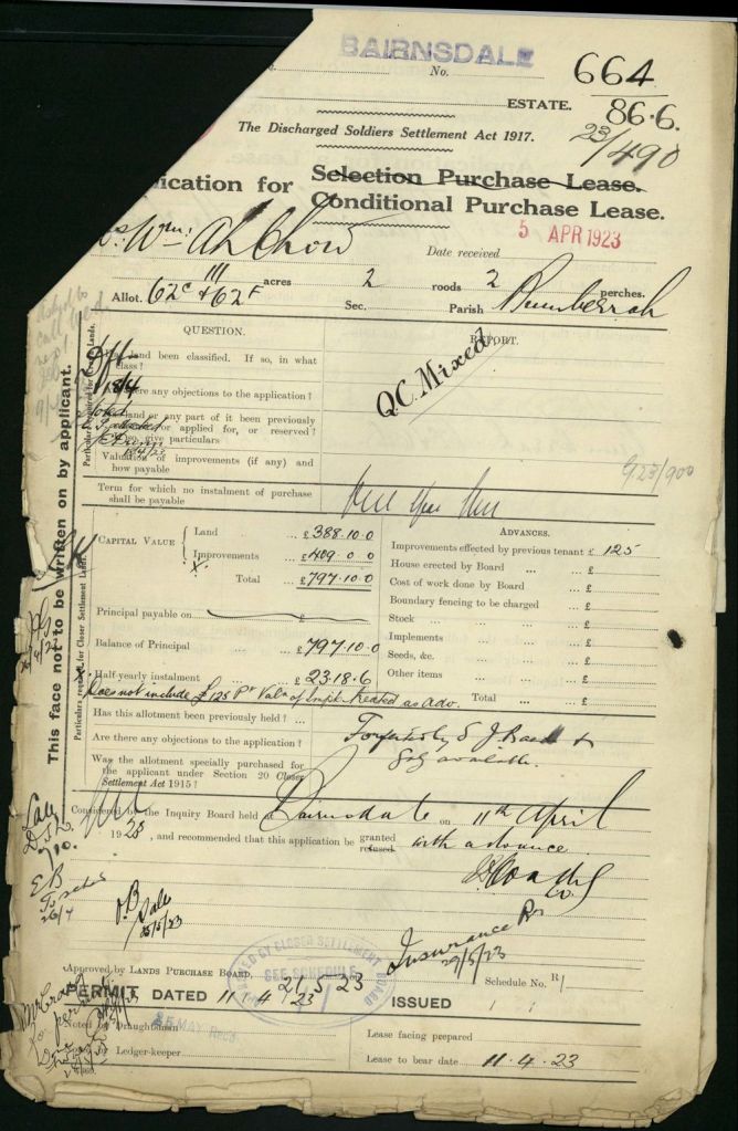
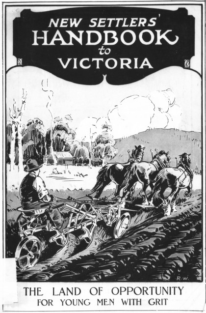

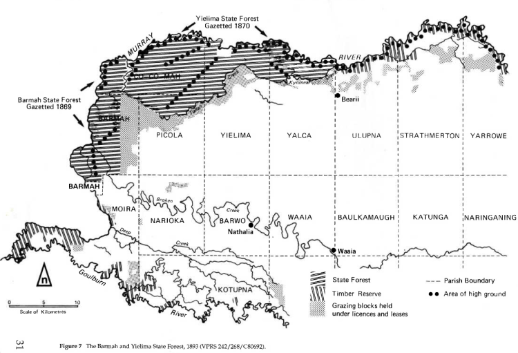


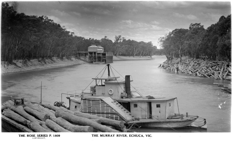
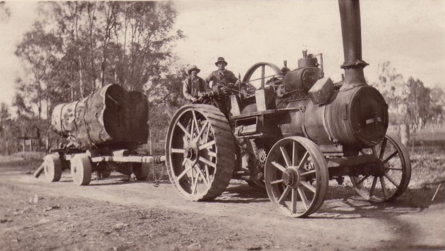


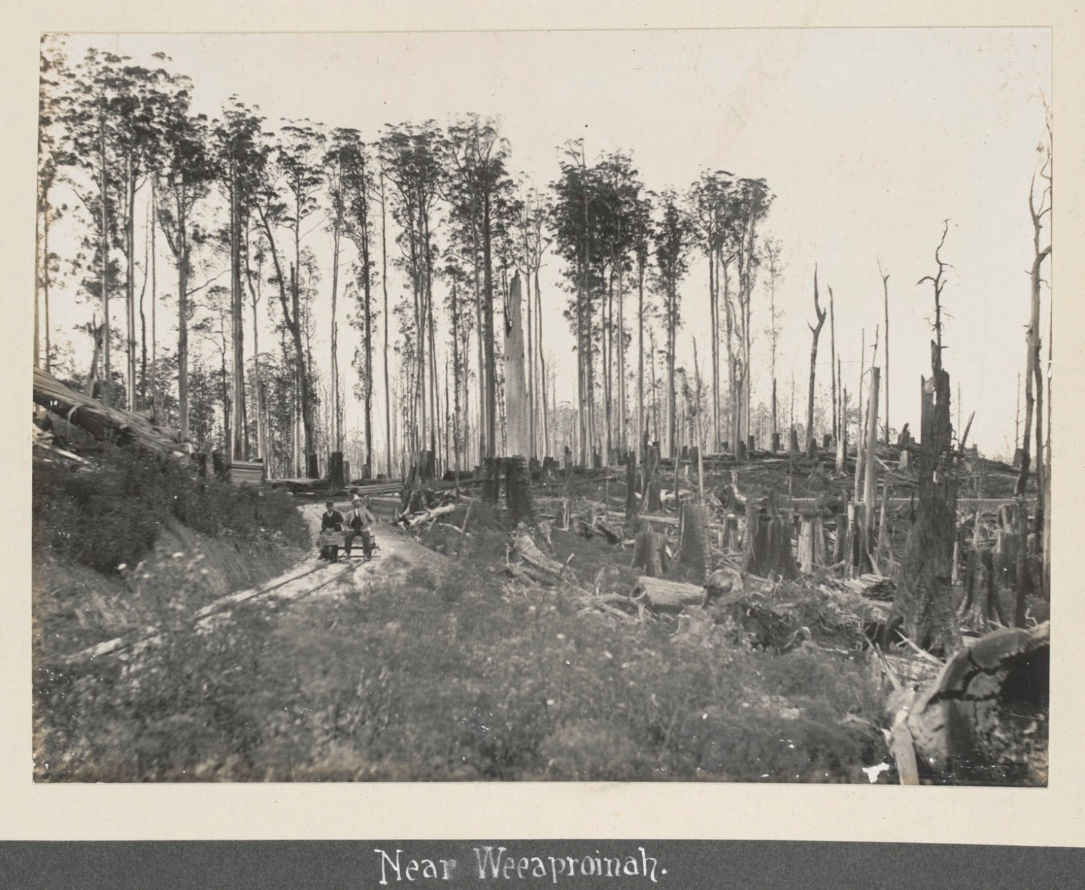

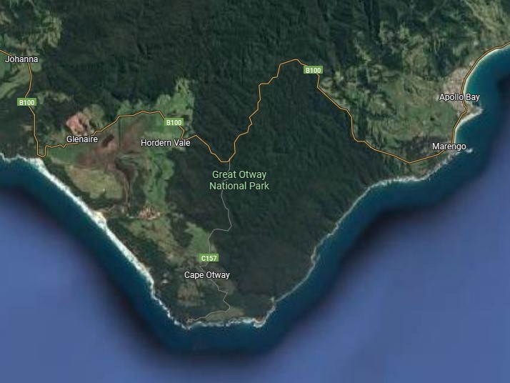

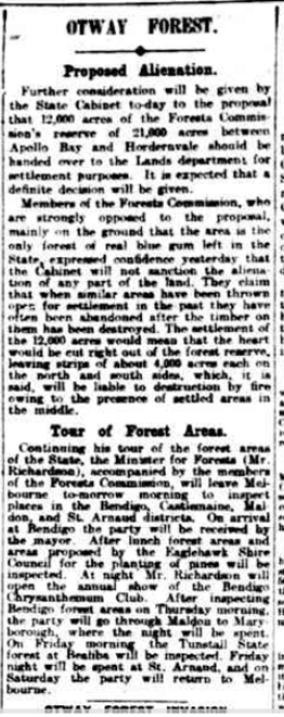
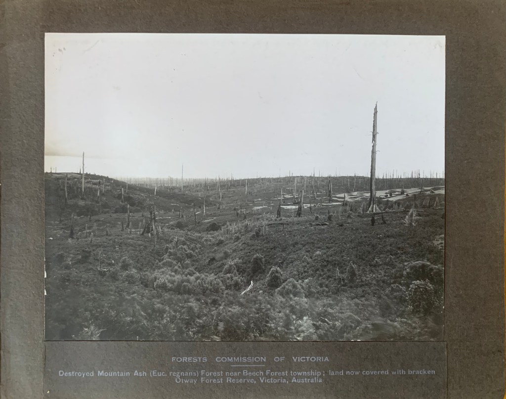
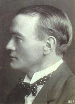


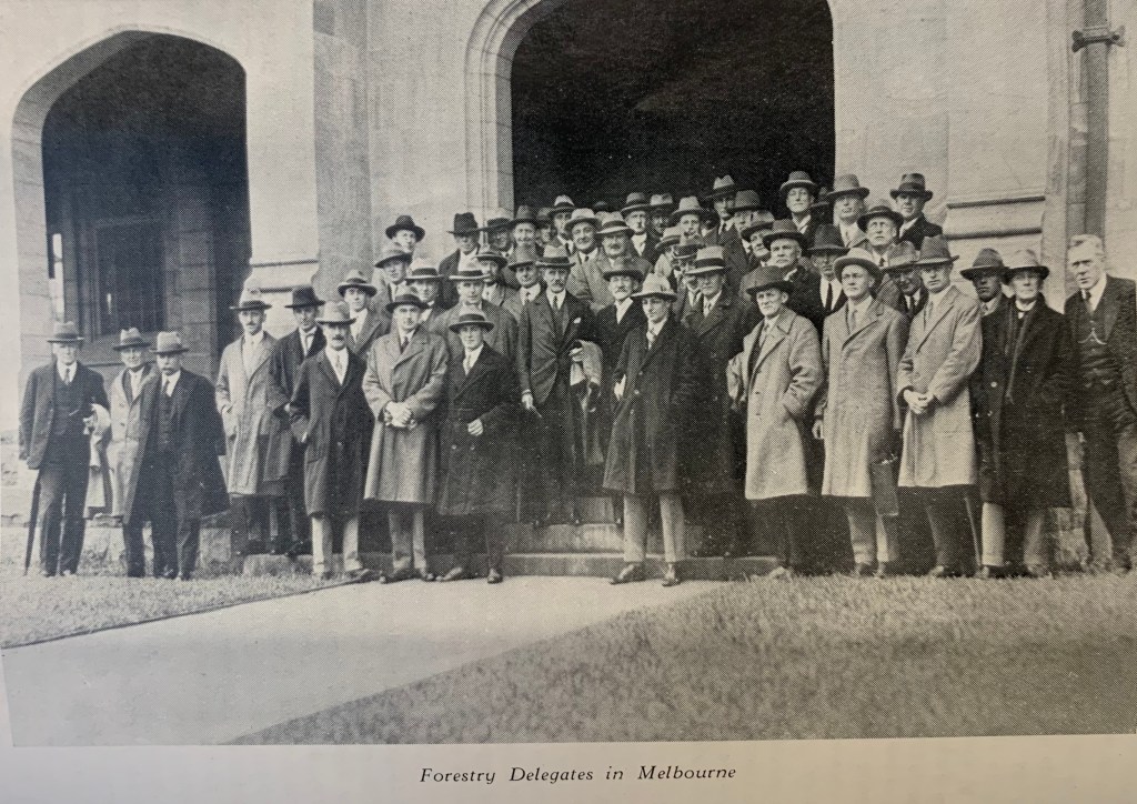
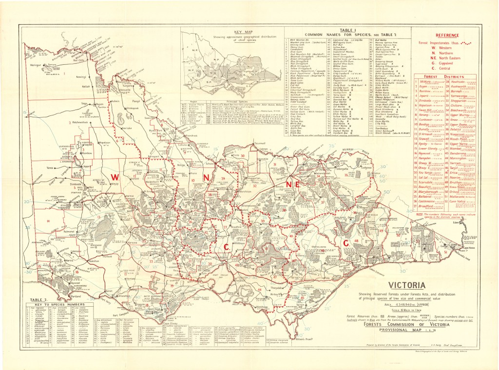
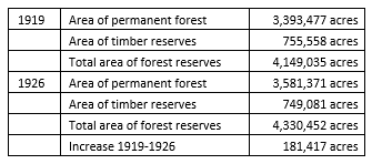
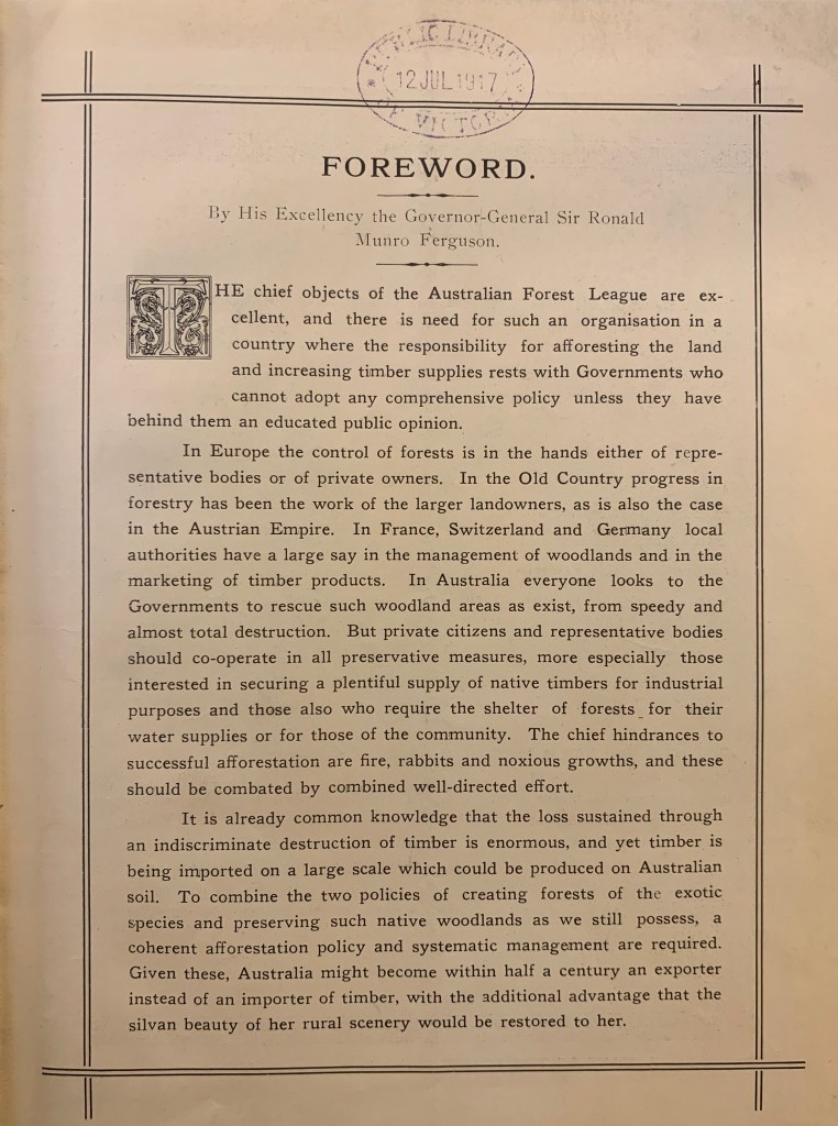


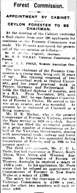
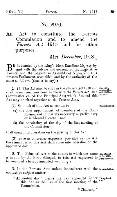


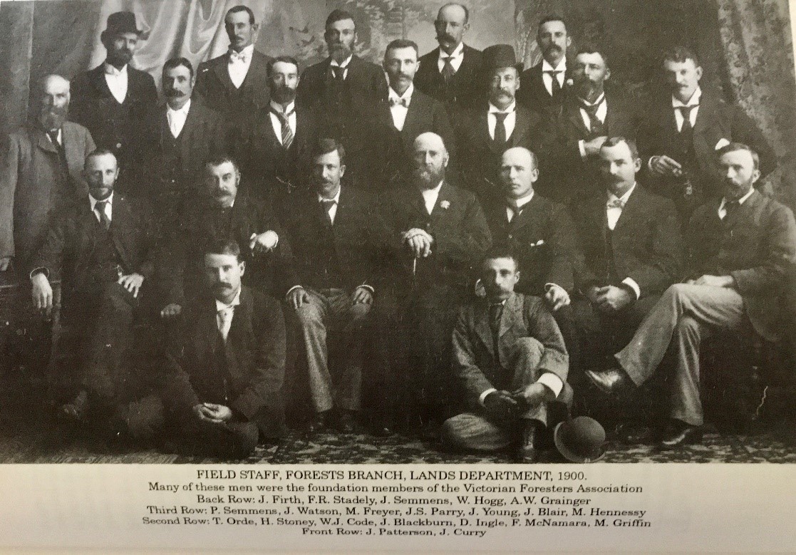
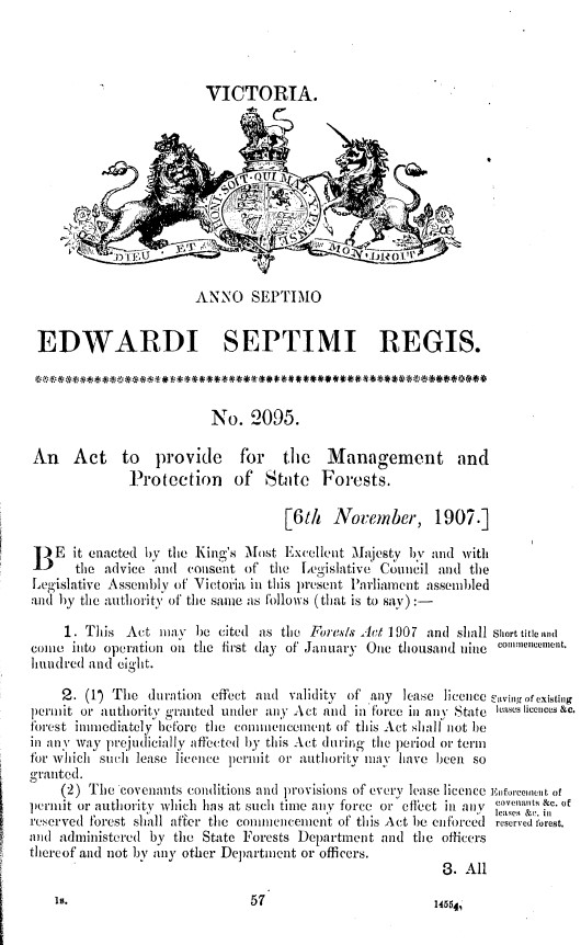


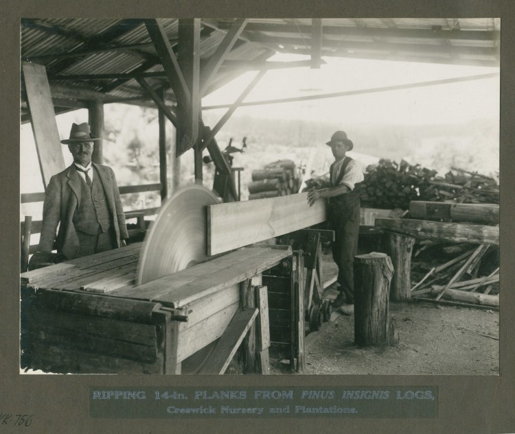

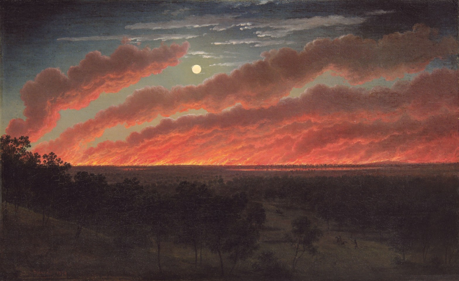
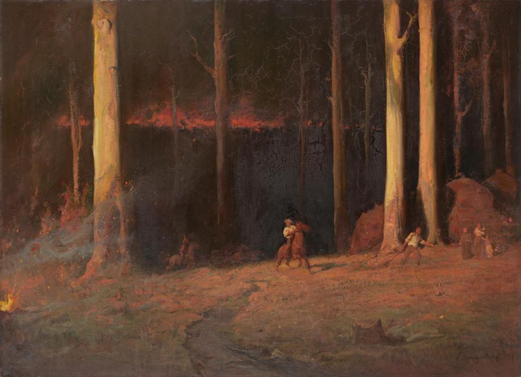
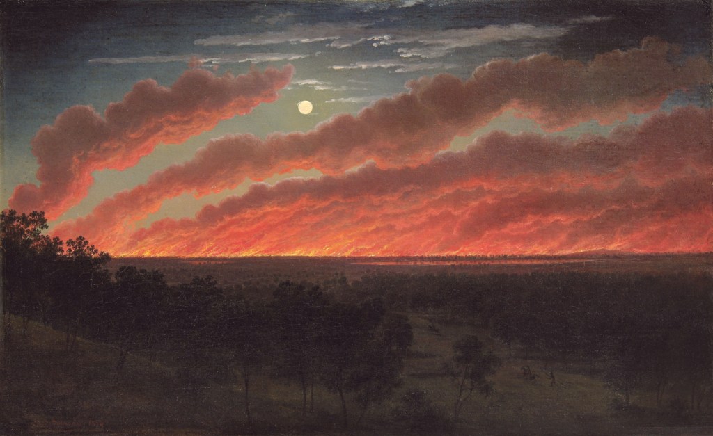
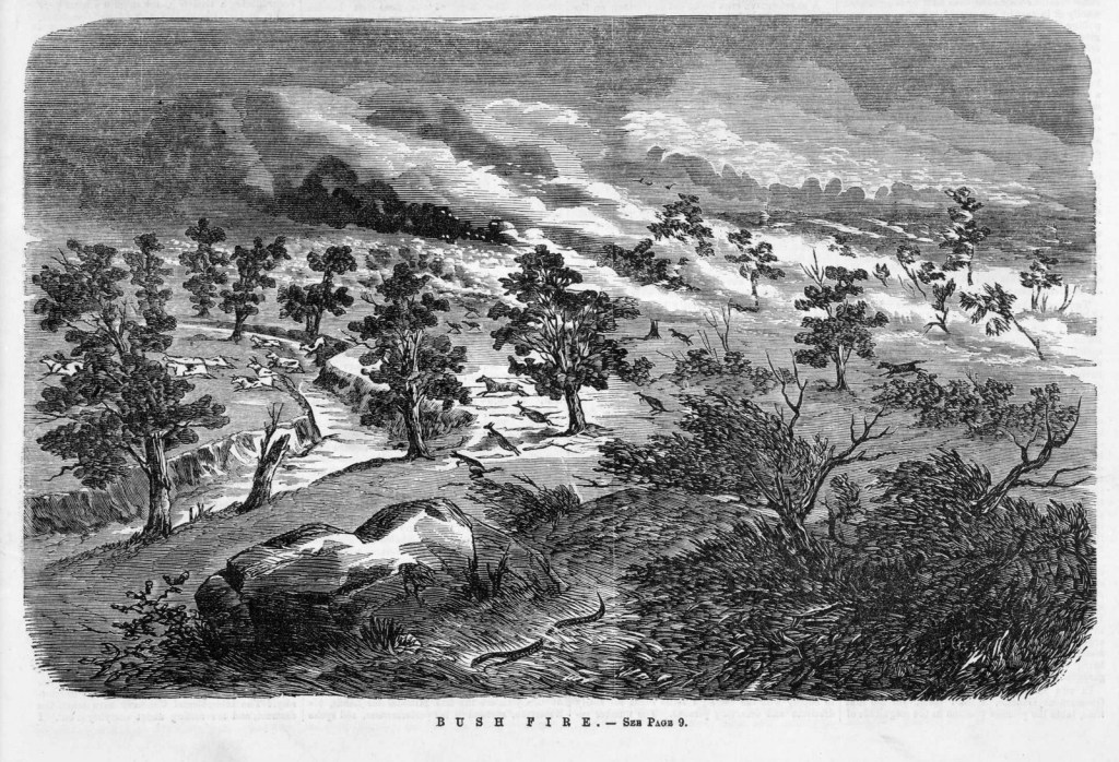
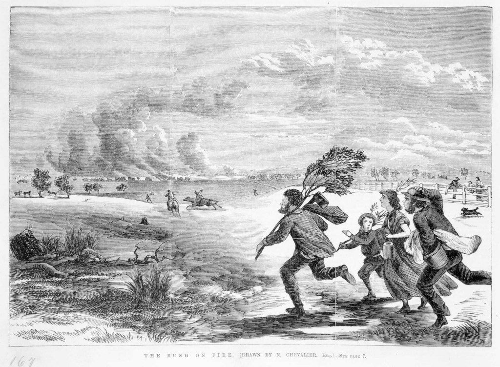
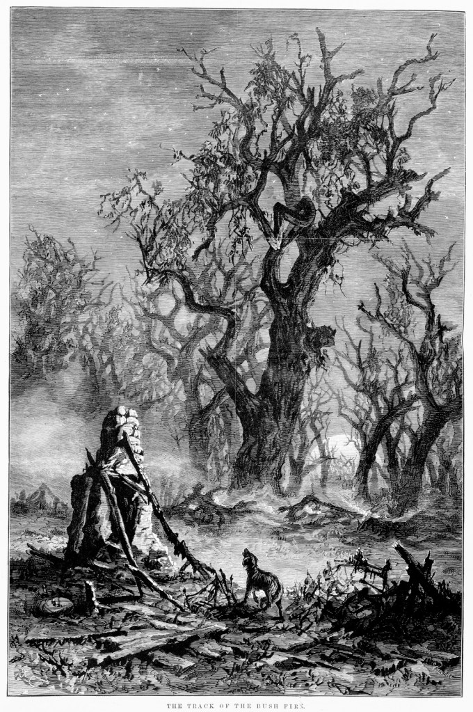
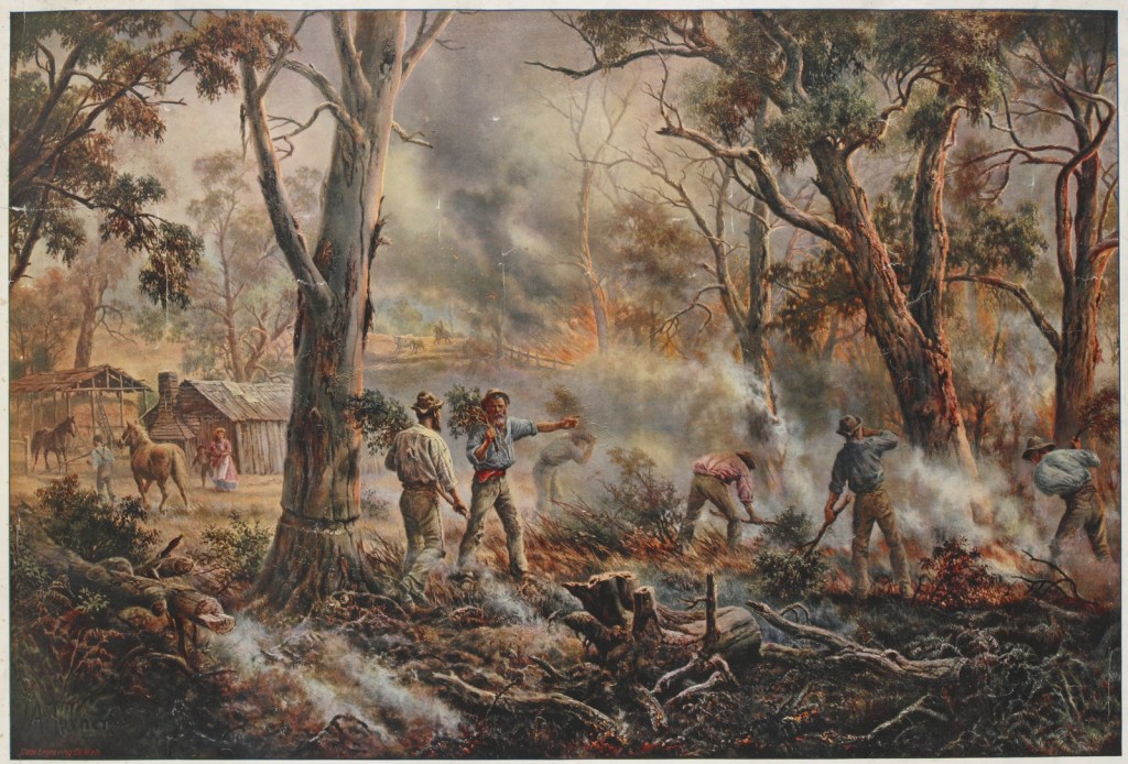
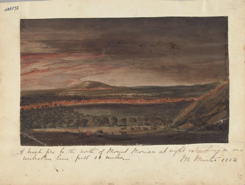
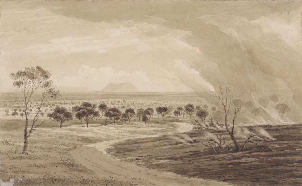


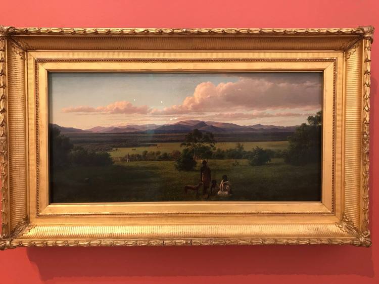

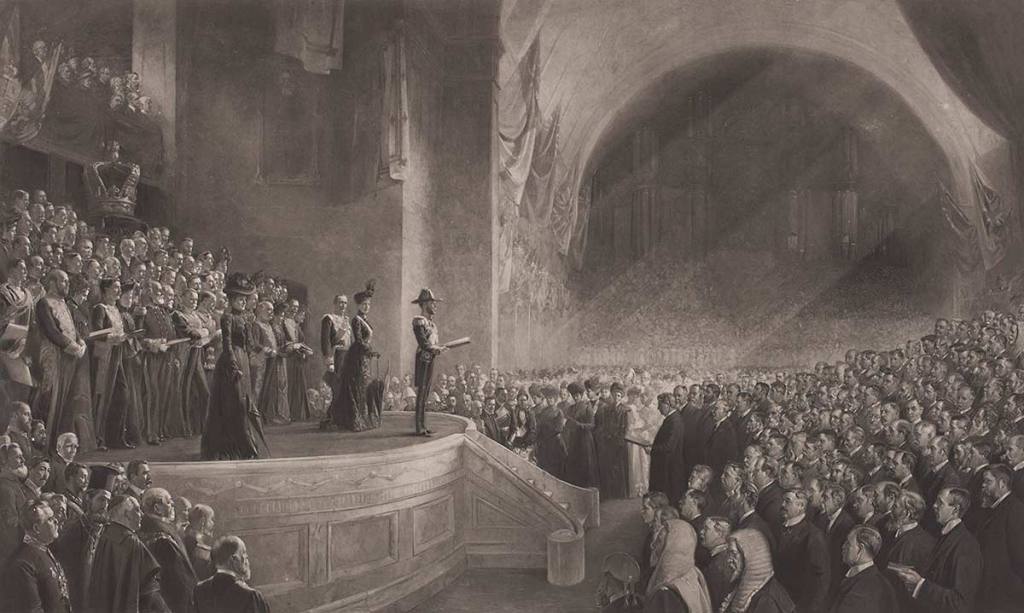


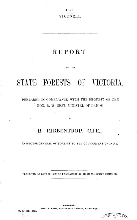


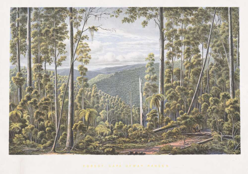

