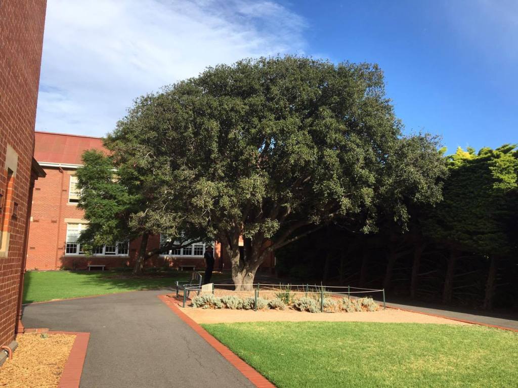
Warrnambool in southwest Victoria has a strong dairy industry that once boasted two factories making thousands of wooden butter boxes.
The first factory was opened in 1896 near the railway station by Welsh immigrant Henry McGennan.
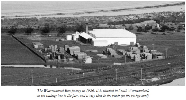
The second factory owned by the Western District Co-Operative Box Company, came a few years later in 1912, on land in South Warrnambool, fronting Pertobe Road. There had been initial negotiations for a single company, but these fell through.
The butter boxes were made with quarter inch sawn boards and timber ply and could hold one cubic foot of butter.
Every three months around 1,200 m3 of kahikatea, or white pine, (Dacrycarpus dacrydioides) was imported from New Zealand. Australian hardwoods were deemed unsuitable because their natural tannins and oils tainted the butter.
But in 1920 the imported pine was switched to cheaper mountain ash (E. regnans) from the Otways once a way was found to reduce the taint using a neutral coating.
The new process enabled butter boxes to be manufactured for one shilling and nine pence each compared to two shillings for New Zealand boxes.
To source the mountain ash timber the Co-Op purchased three abandoned agricultural blocks totalling 400 ha in the head of the Aire River about 8 kms east of Beech Forest and built a sawmill. Conditions were harsh and a good day’s output, under manager Charles Brown, was around 10 m3.
The roads were impassable in winter, so the company also built its own timber tramline through the bush for 3 kms to the Olangolah Road and then along the road for further 3 kms to make a connection with an earlier built tramway which joined onto the railhead at Beech Forest.
The remote box mill worked until 1926 when the bush was cut-out and the area abandoned.
The Warrnambool factory then turned to other suppliers of timber. This move kept the plant going for several more years until a fire in 1936 which damaged part of the works. The company then closed the factory and moved its operations to Melbourne.
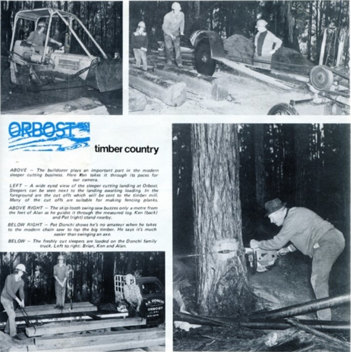
The figures for railway sleepers produced from State forests are simply astounding.
More than 26 million were cut between 1919 and 1986, primarily from the red gum forests along the Murray, the yellow stringybark forests of Mullundung near Yarram and greybox from East Gippsland.
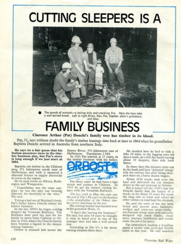
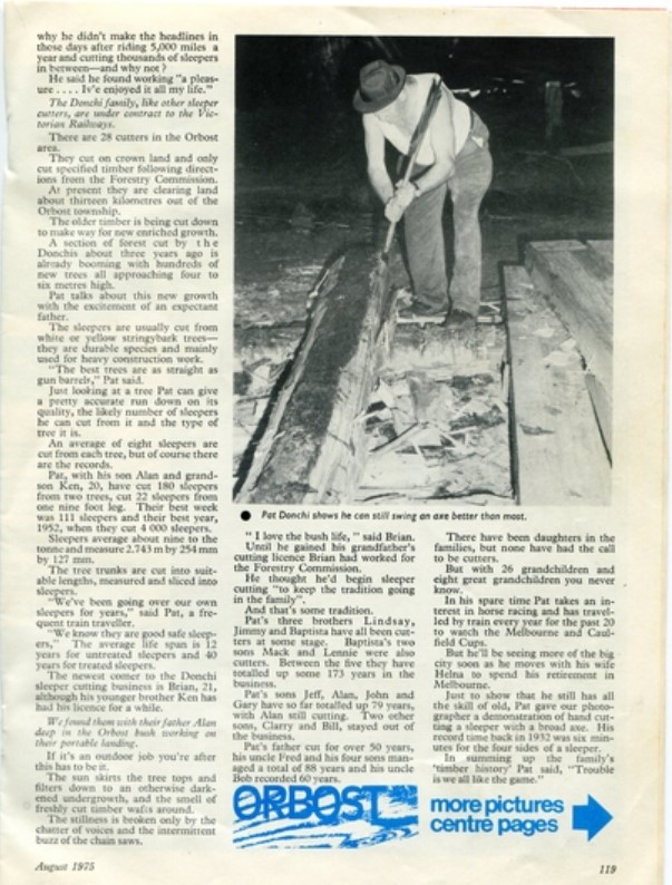
Sleeper cutting began around Orbost in the 1920s and there are records of up to 150 sleepers being cut from a single tree.
Initially cut by hand with a broad-axe and adze most sleeper cutters switched over to terrifying swing saws.
This article about the well known Donchi family from Orbost appeared in Victorian railways magazine in August 1975.
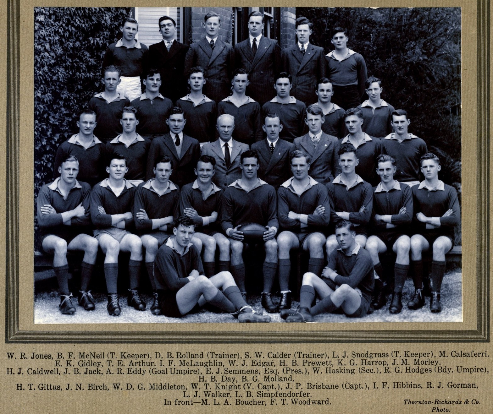
For many years, the number of students at the Victorian School of Forestry (VSF) at Creswick was too small to field its own competitive football team.
In 1942 there were only about 17 students, but in 1944 the annual intake increased, with the result that by 1946 the number in residence had more than doubled to 36.
The 1946 intake was also unique because it included four ex-servicemen that came to the school under the Commonwealth Reconstruction Training Scheme. They were also about two years older than their fellow VSF students with some experience of the “rough-n-tumble” in the outside world.
The ex-servicemen were Jeff Brisbane (RAN), Trevor Arthur (RAAF), Bill Middleton (2 AIF) and Derrick Rolland (RAAF), three of whom were very good footballers.
Early in 1946, Tom Evans, Secretary of the Clunes League football competition (and later an MLA) visited the School and suggested that it enter a team. The Principal, E J Semmens was a strong supporter.
But setting up a new football team would be expensive. Funds would be required for team guernseys (forest green being the natural colour of choice), plus footballs, bus hire for away matches, and many other overhead expenses.
The School had no sports fund, and the students received no cash allowance. Moreover, Creswick township already had a football team, so the VSF students couldn’t expect much local financial support for a rival team.
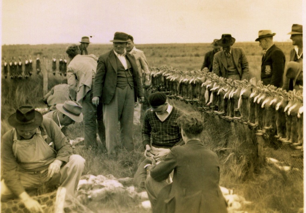
So, the students decided to fund the new team themselves and held weekend rabbit drives in the heavily infested paddocks around Newlyn. They also cut firewood in the school bush to support their fledgling club’s modest budget.
The VSF team went well and played in the 1946 grand final, only to be defeated by Smeaton.
The forestry school fielded a team for several years and many students also played successfully in other local teams. The Captain, Jeff Brisbane, had an invitation to play at a senior level with Geelong.
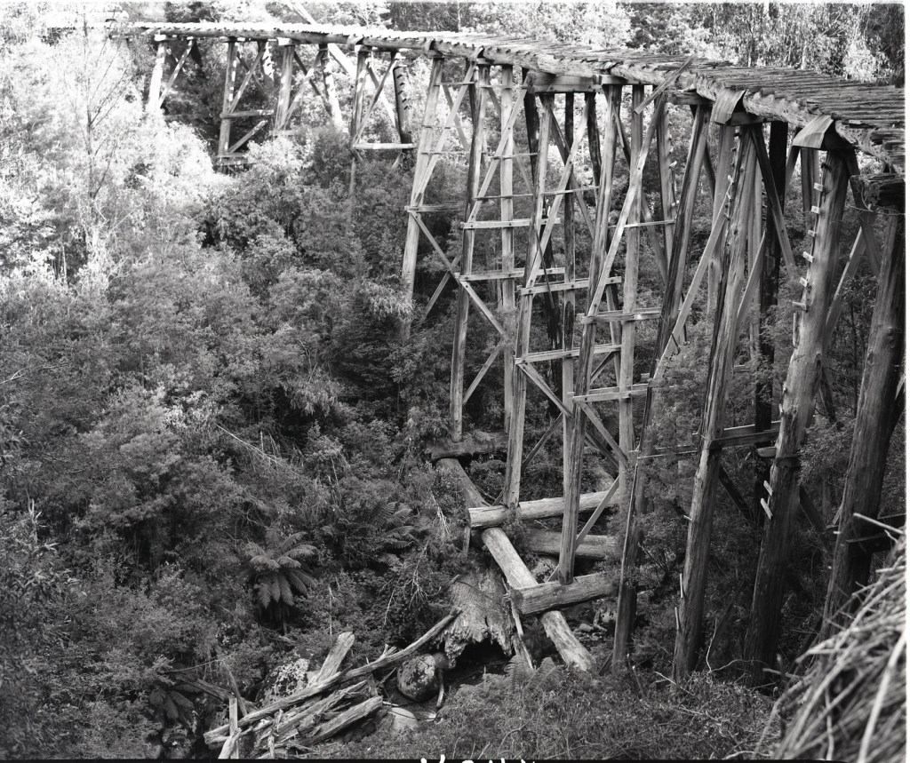
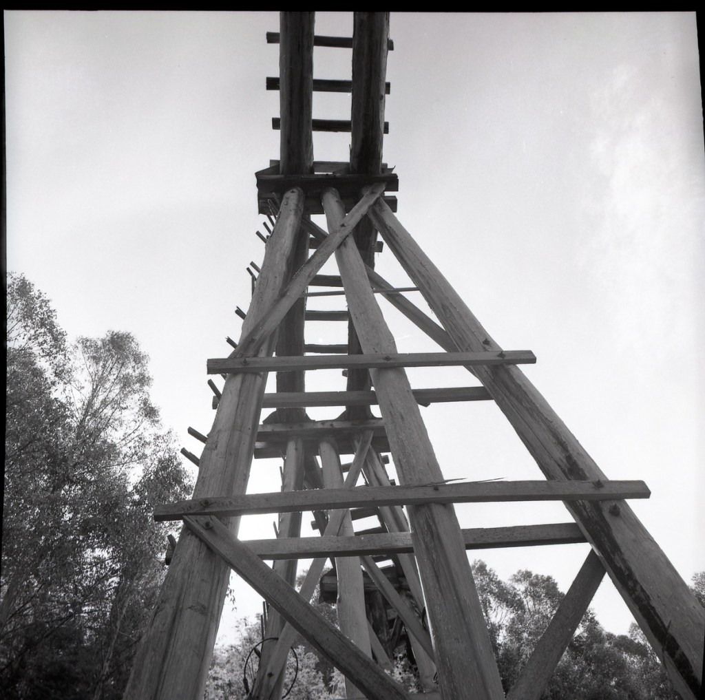
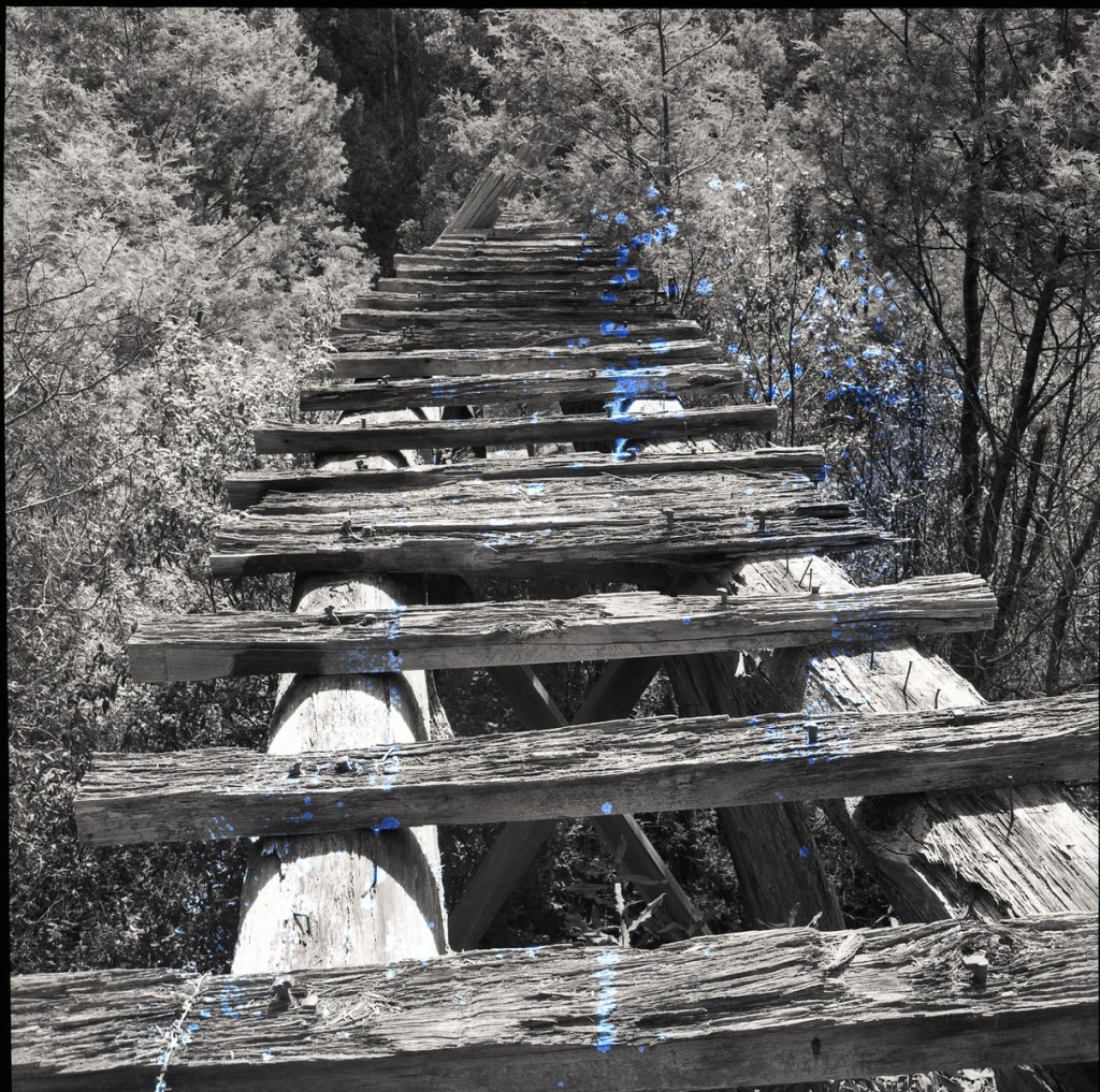
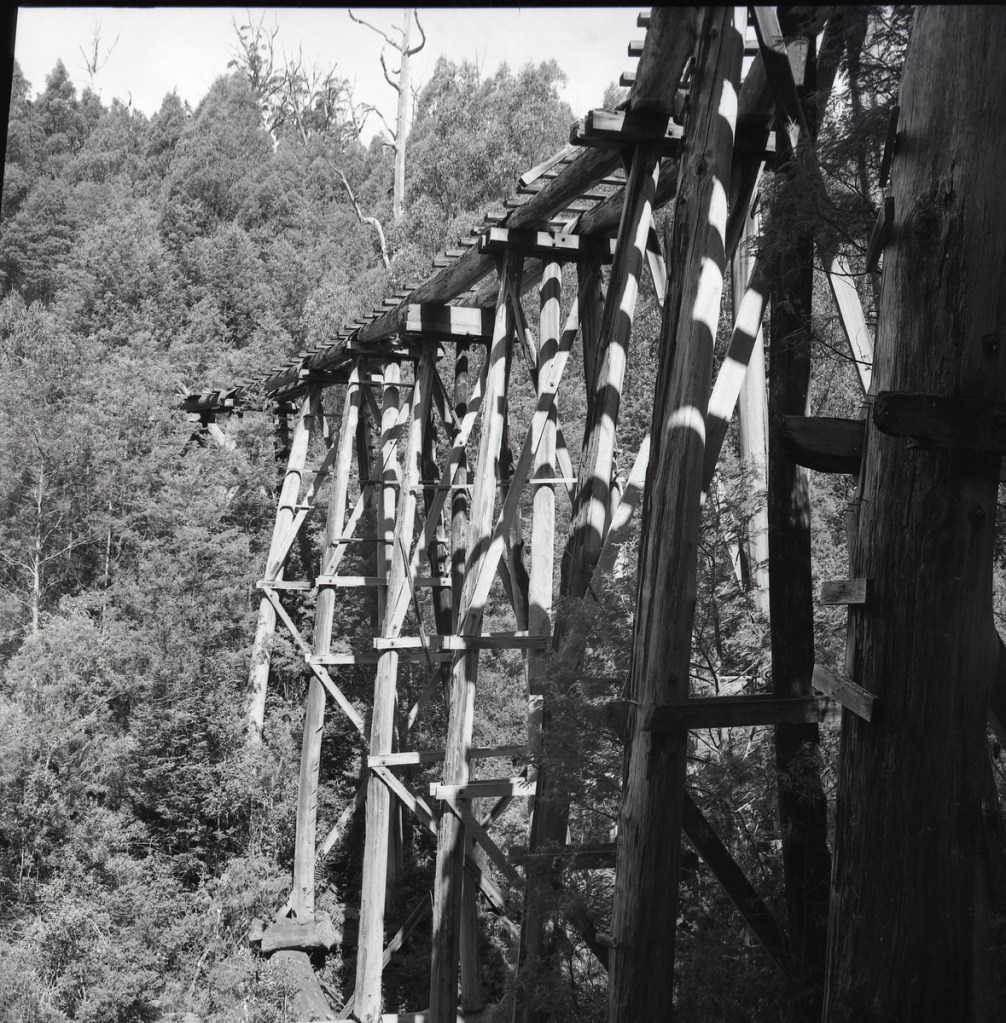
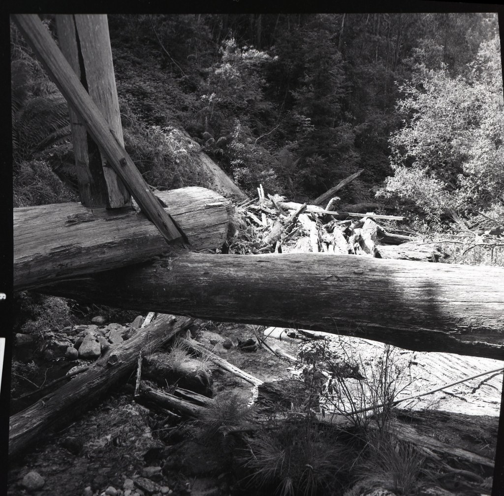
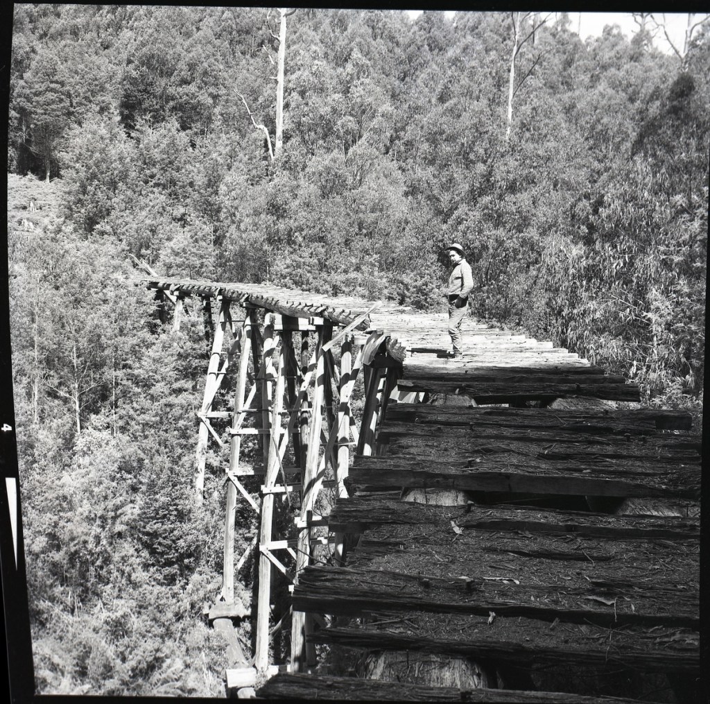
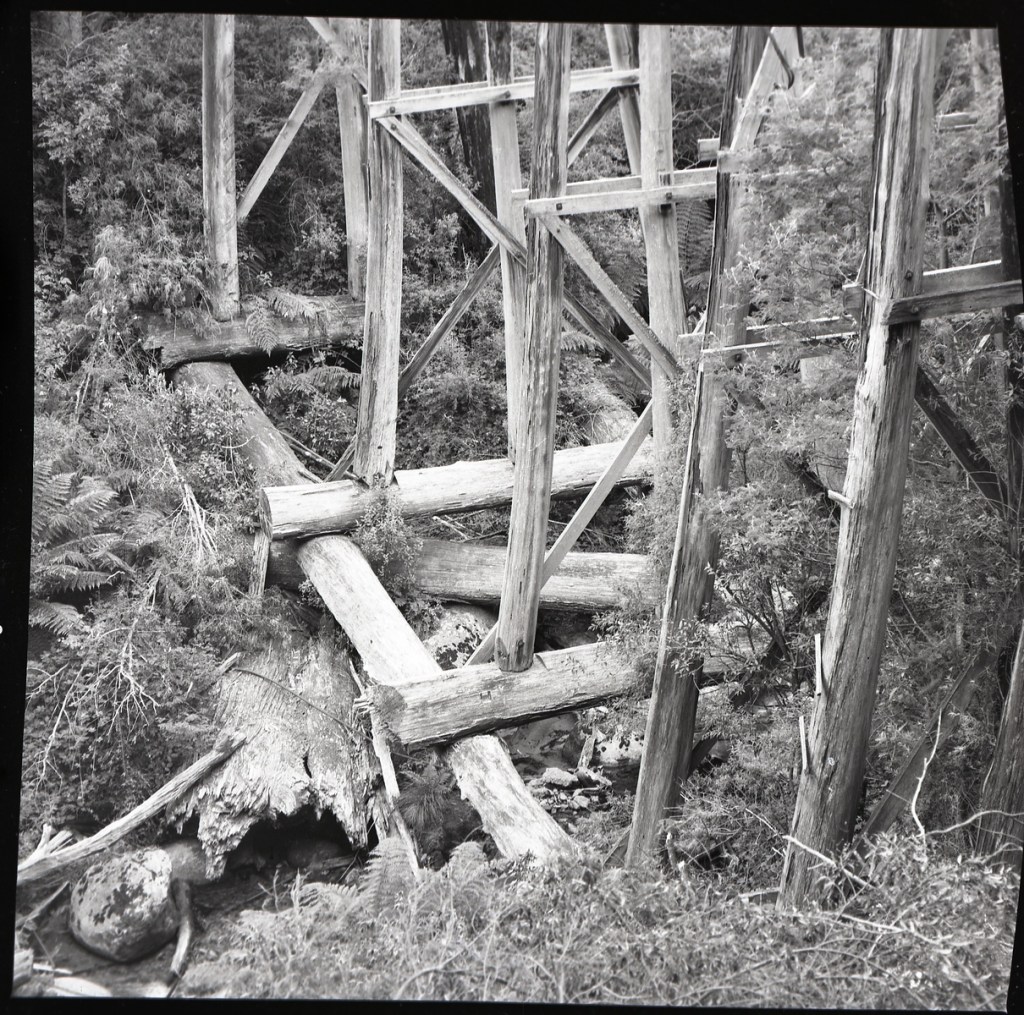
Before the fires, the well-established Ezards company already operated several sawmills and had constructed (and owned) a section of tramway in the Thomson Valley from Erica to a point just beyond the iconic South Cascade Bridge.
After the fires, the Forests Commission extended the line and operated a separate tramway further north as far as Little Boys. The Commission ran this section of line with two small diesel rail tractors.
But Ezards closed all their mills around Erica in about 1950 and then shifted operations to Swift’s Creek, north of Bairnsdale.
The Forests Commission was unable to reach an agreement with Ezards over the use of the company railway line from Erica, so the company ripped up their tracks and sold the metal rails. This effectively left the section of FCV track marooned from the South Cascades Bridge to Little Boys.
But at the time, there was a major technological shift away from steam and rails to diesel and roads, so the curved rail bridge over South Cascade Creek was abandoned.
The current Thomson Valley Road more-or-less follows the alignment and grade of the old FCV rail line as it hugs the contours of the hillside.
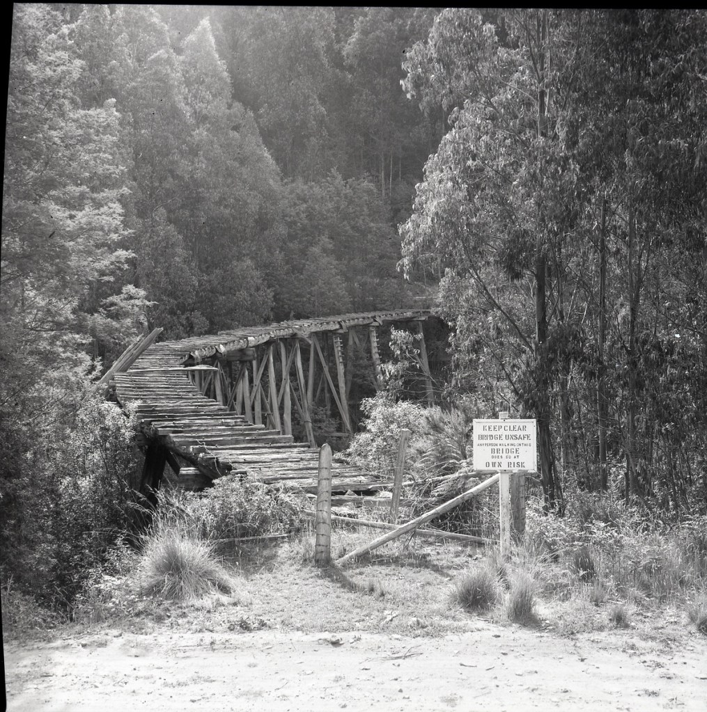
However, the South Cascade Bridge became a popular visitor spot but by the late 1960s the Commission became concerned that the slowly decaying structure was too dangerous for the public to walk over. And there was no funding to repair it.
In 1968, Max Boucher was local District Forester and Bernie Evans was the senior assistant, while Tony Manderson and Bill Clifford were also based at Erica.
Max reluctantly gave the order to demolish the South Cascade Bridge. It was done by the local FCV district staff under the direction of the Commission’s explosives expert “Blow em up” Charlie Saunders.
Bernie and Tony together with a couple off the crew scrambled down through the steep gully laying explosives at the base of the various pylons. Charlie was a large man and happily supervised most of the operation from the road.
It took a couple of goes to demolish the bridge (the structure wasn’t as fragile as everyone thought) and there were still a few metres of it left on the south side that was subsequently fenced off.
It’s often reported that the Army Reserve blew the bridge up, but this is not so, although that may have become involved in some later demolitions.
Photos: FCRPA Collection
Photograph probably taken in the mid-1940’s (Source; FCRPA) : Thomson Valley tramway, South Cascade bridge
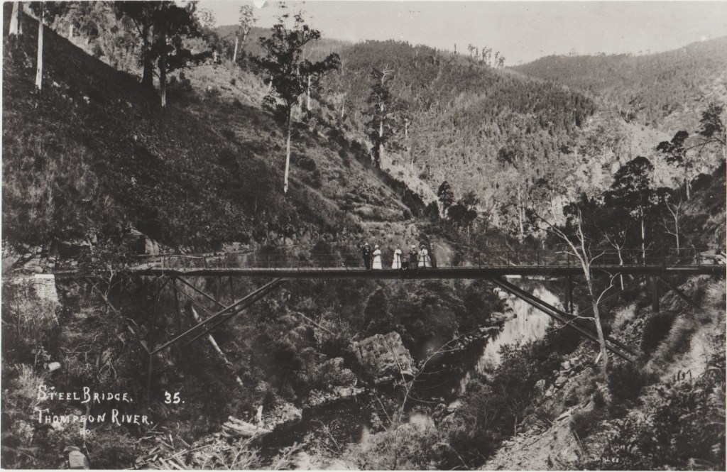
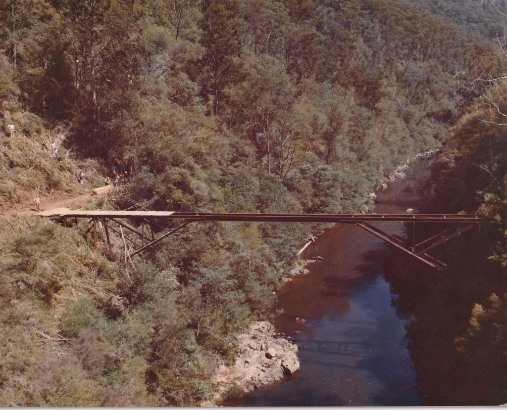
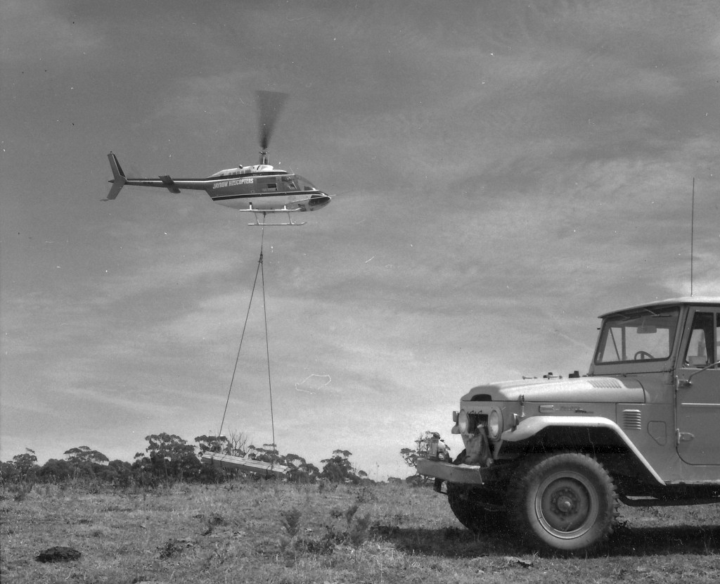
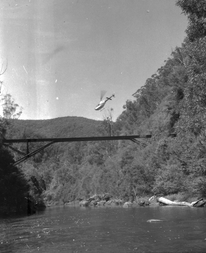
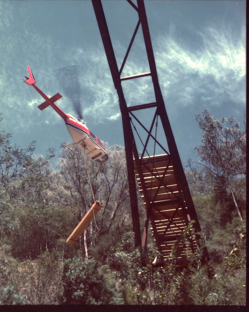
Also known as the Tramway Bridge or the Old Steel Bridge, Poverty Point Bridge was designed by Mr. Timmins, an engineer from the Victorian Railways.
The prefabricated steel components were manufactured by Dorman Long and Co and erected in 1900 by Austral Otis Co from South Melbourne.
Dorman Long and Co was a Middlesborough firm – a city on the Tees straddling the North Yorkshire – Durham border. In Australia, of course, it is best known for its role in the construction of the Sydney Harbour Bridge two to three decades later.
The Poverty Point Bridge was part of a seven-mile, horse-drawn, two-foot gauge tramway to serve the Long Tunnel gold mine in Walhalla during the town’s gold rush.
There was an extensive network of tramways in the bush which transported structural timbers and thousands of tonnes of boiler-wood for the mine’s voracious furnaces.
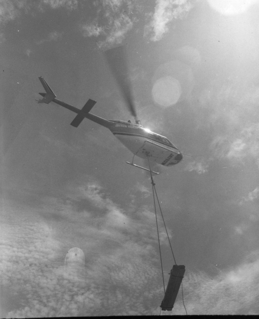
The line closed between Platina and Walhalla in 1944 and the timber deck was later destroyed by bushfire.
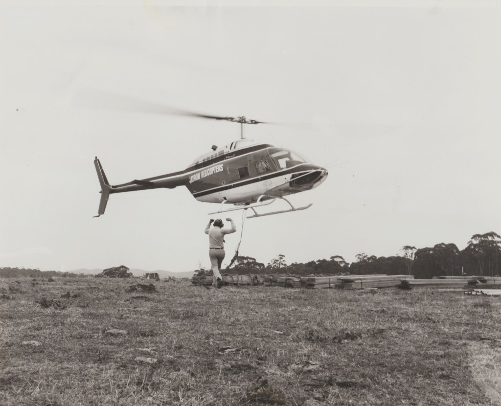
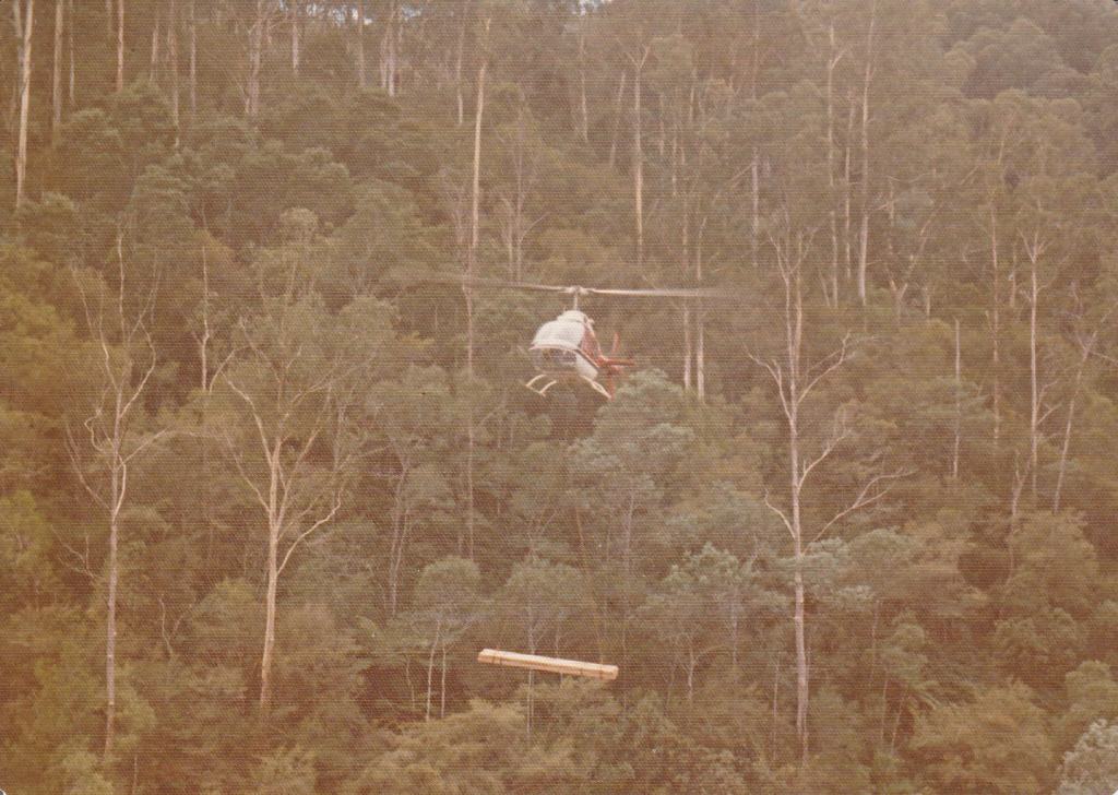
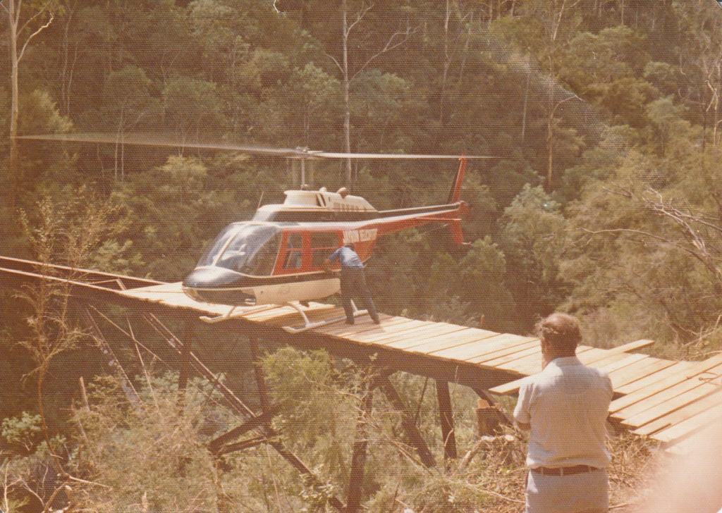
In March 1976, the bridge was redecked by the Forests Commission using a Jayrow Bell 206 Jetranger to sling-load timber to the site.
The bridge is architecturally significant and is listed as state significance on the Victorian Heritage Register.
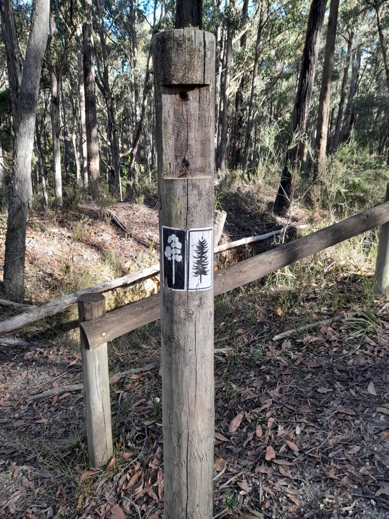
It is also part of the Alpine Walking Track but is currently closed.
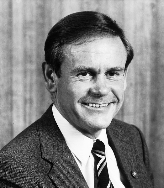
Philip Thomas Crosbie Morrison, sometimes known as PTCM, but more commonly as just plain Tom, was born in 1931 and grew up in Brighton.
It’s alleged that on New Years Eve, Tom, and his younger brother James, climbed the statue of Victoria’s infamous and colourful Premier Sir Thomas Bent, which overlooked the Nepean Highway, and placed a beer can in his outstretched palm. It’s not known if the can had been emptied of its contents or not… but one suspects so…
Tom graduated in 1951 from the Victorian School of Forestry (VSF) at Creswick. He was one of three unrelated Morrison students who attended the school around the same time including Ken (1949) and Graham (1962).
Like so many other VSF graduates before him, Tom’s career began with the Forests Commission Victoria (FCV) in Assessment Branch, and then followed a well-worn path of numerous district postings including Broadford, Powelltown (1954), Dunolly (1957), Bruthen at Mount Taylor (1959-1966), before being promoted as District Forester to Corryong (1966).
In about 1969, Tom had been offered the leadership of an Antarctic expedition, but the Commission refused to let him go on the grounds that he was needed in the organisation. Naturally he was very disappointed with the decision.
During the late 1960s, recreation and conservation on State forest was receiving greater community focus. A key moment for the Commission came in August 1970, then under the new chairmanship of Dr Frank Moulds, with the creation of the Forest Recreation Branch.
This initiative was a first for any Australian Forest Service, and its brief soon widened, and by 1971 it became the Forest Environment and Recreation (FEAR) Branch, firstly under the stewardship of Athol Hodgson and later Stuart Calder.
In January 1971, Tom was one of the founding members of the new FEAR Branch which was based at Treasury Place in Melbourne.
Tom set high standards for recreational facilities in the bush. This included working with FCV Districts to establish signboard workshops at Forrest, Stawell and Benalla, map laminating at Benalla, picnic table and information shelter production at Forrest, and picnic ground fireplace manufacture at Trentham. He also arranged production of the reflective aluminium track markers used on the Alpine Walking Track and Howqua feeder track, and other signs such as the brown and yellow ‘Native Plants and Wildlife Protected in this Forest’ metal signs.
Tom often spoke passionately of multiple-use forestry . . . Water, Wood, Wildlife and Recreation (AKA – the four Ws).
And while with FEAR Branch, Tom also advocated strongly for conservation ideals within the Commission and provided technical advice for the iconic film “The Living Forest” which was produced in 1973.
The 22-minute short film portrays, beautifully for its time, Victoria’s forests and woodlands including its flora, fauna, water and soils, recreation and tourism use, fire management and economic values, including the timber industry. The film briefly examines the Forests Commission’s “multiple use” philosophy and explored the importance of balancing the environmental and economic demands that community’s make on State forests.
Tom continued to make short films throughout his career and developed many important contacts outside the Commission, such as cameraman David Corke, and ABC natural history producer, Dione Gilmour, in the early stages of her legendary career.
With his colleague and graphic artist, Helen Dean, a new interpretations brochure was designed with the slogan “Forests are for Everyone “… a phrase that would come to underscore the ethos at the Forests Commission for many years to come.
In 1973, Tom and Helen together with Mary Crooks (who was a geography student at the time working over the uni holidays), hiked the tracks of the Grampians making notes, taking photos and suggesting illustrations for Mary’s publication – Field Guide to the Grampians Wonderland Forest Park.
Tom was also a prolific pipe smoker, just like his father, and in those days public servants could puff away at their desks oblivious to those around them gasping on the fumes. His friends recall a big glass ashtray that sat on his desk full of smelly pipe cinders.
In a pre-computer era, many of his tasks involved reading technical documents and writing memos and manuscripts in longhand for the office typist. Tom became most adept at with his legs outstretched on the visitor’s chair that everyone had at their desk in those days. Tom had a great command of the English language and asked the organisation for a new-fangled Dictaphone but was rejected because the higher-ups thought everyone might want one. Like many, Tom was known to get frustrated by small-mindedness and bureaucracy.
Tom also had a great fondness for old-style English humour such as Spike Milligan and the Goons. He had an infectious capacity to laugh spontaneously with such freedom and enthusiasm at all their silliness.
His humorous contributions to the banter around the morning tea trolley were legendary. The shenanigans extended to a mock radio program at a FEAR Branch lunch, complete with theme music and commentary.
Never very far from a small portable radio, Tom would readily tune into anything that spiked his interest or curiosity.
At the beginning of 1976, Tom took a stint at his alma mater, the Victorian School of Forestry, as lecturer for the mature aged certificate of applied science students.
Tom lacked a university degree and always felt this had been a handbrake on his career progression. So, it was while at Creswick, and after a very long gestation, that Tom was finally awarded a Diploma of Forestry (Victoria) for his thesis – “The Natural Occurrence, Distribution and Utilisation of Natural Resources in Victoria”.
A great communicator, Tom was always seeking other people’s opinions and ideas, and genuinely listening to what they had to say. He was widely respected and popular with his students but chose to return to Melbourne at the end of 1981 as an Interpretation Officer.
And just like his father, Tom kindled in anyone who spun into his ever-enthusiastic orbit, an appreciation of the bush, of its simple pleasures, and fostered great care for the outdoors.
People who knew Tom attest he was a gentle soul, a delight to work with, very humorous, very approachable, very kind, very caring, very encouraging, very compassionate and wanting to help others.
But sadly, Tom died suddenly in 1982, aged 51, of a hereditary heart condition.
Philip Crosbie Morrison
They say, “apples don’t fall far from the tree”, and there seems little doubt that Tom was strongly influenced by his father, Philip Crosbie Morrison, the legendary naturalist, educator, journalist, broadcaster and conservationist.
Crosbie Morrison, as he was widely known, broadcast on radio 3DB-3LK during the 1940s and 1950s. Thousands of Australians learned natural history during his Sunday evening radio program, “Along The Track”, which became an institution.
His broadcast opened with a burst of kookaburra laughter, then the tones of a Sherbrooke Forest lyrebird, next the introduction of ‘Mr Crosbie Morrison, Master of Science, editor of Wild Life magazine, followed by the familiar and friendly, “Good evening listeners”.
In his mellifluous voice he told his listeners how to identify the small bush creatures, such as pygmy possums and feathertail gliders that came into their suburban lounges in a load of wartime firewood.
The popularity of the man with the pipe, the moustache and the Harry Potter glasses was enormous, as was his fan mail, which sometimes contained live spiders and other bits of flora and fauna for identification.
Before the programme was five years old, a survey found that 78% of all Victorian radios on Sunday evening were tuned into Morrison. In following years, the programme was relayed throughout Australia, New Zealand and even extended to South Africa.
Prominent in many conservation organisations, Crosbie Morrison lobbied relentlessly for the protection of environmentally significant areas of Victoria such as Wilsons Promontory. He was appointed the founding director of the Victorian National Parks Authority in 1956.
Philip Crosbie Morrison died suddenly in 1958 and left a remarkable legacy.
The Australian National Botanic Gardens in Canberra dedicated the Crosbie Morrison building as its Environmental Education Centre.
Thanks to Rob Youl, Helen Dean, Kester Baines, Mike Leonard, Brian Fry, Mal McKinty and Dennis Williamson for contributing to this tribute.
Tom Crosbie Morrison at Creswick – C 1978. Source: FCRPATom Crosbie Morrison (complete with pipe) & Ray Baker at Gunbower c1974. Source: FCRPATom and James Crosbie Morrison. C 1930s. Source: State LibraryThe Morrison family in 1952. Philip Crosbie Morrison (standing), his wife Lucy with sons James (left) and Tom (right). Unknown Pooch and location. Source: VNPAPhilip Thomas (Tom) Crosbie Morrison graduated from the Victorian School of Forestry (VSF) in 1951. Source: FCRPATom and Ken Morrison at VSF in 1949. Source: FCRPAPhilip Crosbie Morrison was a legendary naturalist, educator, journalist, broadcaster and conservationist.
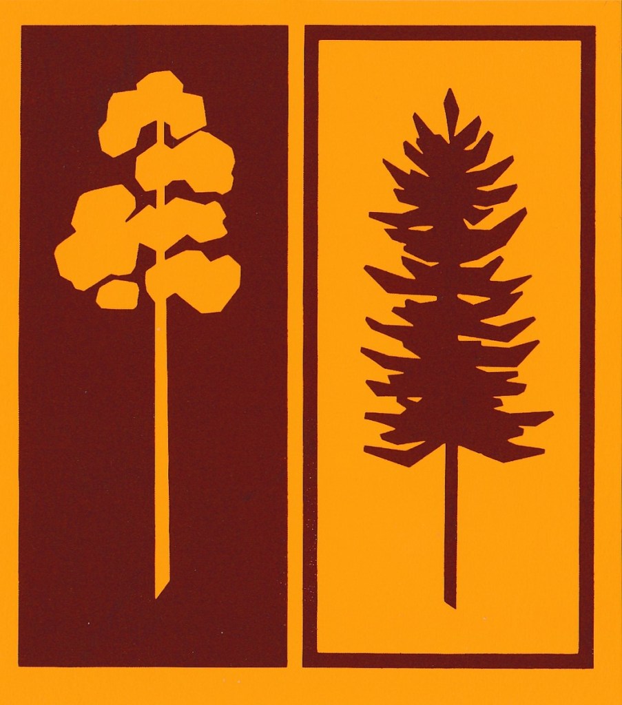
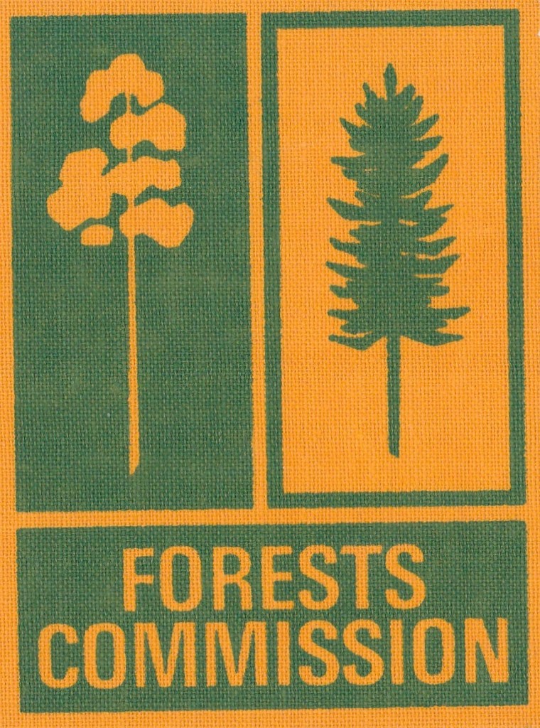
The iconic Forests Commission Victoria (FCV) “two-tree” logo was designed in the early 1960s by graphic artist, Alan Rawady.
The modern logo replaced the circular emblem with myrtle beech fronds that had been in service for many decades.
Alan had the grand title of Artist and Display Designer and was part of the three-person Publicity Branch with Alan Watts as the manager and George Self as the photographer. They were situated on the third floor of 453-455 Latrobe Street. The building is gone now.
In 1961, Morris Carver who was Assistant Secretary to the FCV at the time, commissioned Alan to “design a logo to make them gasp in wonder and amazement’. The Chairman, Alf Laurence, personally approved the final design in 1964/65.
There were three colour versions of black-white, brown-gold and greenish. They came in various sized adhesive stickers, reflective ones on a magnetic backing to attach to car doors, as well as sew-on badges. The new brand also adorned FCV stationery and offices.
The standard colours for the mission-brown logo were Pantone Matching System – BROWN-PMS 168 and GOLD-PMS 137.
The logo was to become the cornerstone of corporate graphics when the Commission created the Forest Environment and Recreation (FEAR) Branch in 1971.
The simple and bold design remained in use until the mid-1980s when it was replaced by a circular and very non-descript logo during the Conservation, Forests and Lands (CFL) era.
But staff never really warmed to the new CFL logo, which some said looked more like a “sheep’s bum”. It seemed that ex-Fisheries and Wildlife staff fondly clung to their iconic platypus badge, and ex-National Parks Rangers to their hopping kangaroo, while the “two-tree” logo was cherished by ex-FCV employees.
Alan Rawady recalls that the material used to screen print the sticker at that time was probably a Fasson or a Jacpaper product sourced from Europe. The material was (then) high quality white mylar which had an aggressive sticky back and was virtually indestructible. The screen-printing was done by Buckle Bros. in Lennox Street Richmond, and ink was nearly toxic and smelled abominable.
There are still a couple of stickers around the bush, but not many… A relic was recently discovered at Blackwood, still completely identifiable after 40 years, even if a little battle scarred.
Collectors’ items for sure…
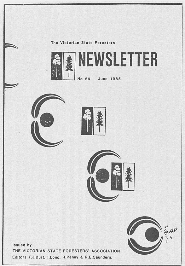
The original FCV logo had been in use for decades.he cover of the Victorian State Foresters’ Association newsletter summed up the feeling of many FCV staff. Source: FCRPA CollectionStaff never warmed the the “sheeps bum” CFL logo. Source: Rod Johns
Forty years ago today, on 4 May 1983, the Minister for Forests, Rod Mackenzie, announced in Parliament the State Government’s intention to “shake up” the forest service.
The Forests Commission Victoria (FCV), and its predecessor the State Forests Department (SFD), had been stable and relatively autonomous authorities responsible for management and protection from bushfire of Victoria’s public forests for over 75 years.
A year earlier in April 1982, John Cain had been elected Premier of Victoria and replaced Liberal leader Lindsay Thomson as the first Labor State Premier after 27 years of unbroken conservative government.
The new Cain Government had formulated a range of ideas while in opposition and was keen to get busy. The reforms were to include radical changes to the operation of the State public service including a move to greater central and budget control by adopting a departmental model rather than independent commissions. Other organisations like the MMBW and the Victorian Railways were also in their sights.
A few months after the announcement, on 1 September 1983, the Forests Commission lost its discrete identity when it was merged into the newly formed Department of Conservation, Forests and Lands (CFL) along with the Crown Lands and Survey Department, National Park Service, Soil Conservation Authority and Fisheries and Wildlife Service.
The subsequent amalgamation and restructure were a protracted and disruptive process over the next three years. Many experienced forestry and firefighting staff chose to leave, while others saw it as a career opportunity to diversify, but most just had to “suck-it-up” or end up in the redeployment pool.
There was a short period of stability, but then the tempo of change seemed to accelerate, with many more departmental restructures occurring over the subsequent four decades. I can count nine major departmental name changes including…
Department of Conservation Forests and Lands (CFL) – 1983
Department of Conservation and Environment (DCE) – 1990
Department of Conservation and Natural Resources (CNR) – 1992
Department of Natural Resources and Environment (NRE) – 1996
Department of Primary Industries (DPI) – 2002
Department of Sustainability and Environment (DSE) – 2002
Department of Environment and Primary Industries (DEPI) – 2012
Department of Environment, Land, Water and Planning (DELWP) – 2014
Department of Energy, Environment and Climate Action (DEECA) – 2023
In 1983, some 70–80% of all CFL personnel were located outside Melbourne, but over time, and with each successive budget and staff cut, the balance shifted with the number of regional offices in country Victoria radically falling from an initial eighteen down to six.
The demise of regional influence also corresponded with greater centralisation of decision making in head office combined with, what seemed, an exponential growth of media and ministerial advisors.
There were further splits and amalgamations with Agriculture and Planning, first moving in, and then moving out of the department, as well as the formation of the Victorian Plantation Corporation (VPC) in 1993, Catchment Management Authorities (CMAs) in 1994, Parks Victoria in 1996 and VicForests later in 2004.
Moreover, the department experienced no less than 7 State Premiers (both Liberal and Labor), 15 Government Ministers, 13 Director-Generals / Secretaries and 9 Chief Fire Officers, all of whom wrought their own changes which added to the organisational precariousness.
I’m not 100% certain of some of the dates, and in later years the expanding mega-department had multiple portfolios and multiple Ministers, so I may well have missed someone.
I also can’t remember exactly how many other minor internal changes and convoluted job titles have been inflicted but I seem to have accumulated a large collection of name tags and business cards.
It was sometimes very difficult to remain buoyant while getting used to yet another tongue twister acronym. Staff also became the butt of so many tiresome jokes like…
CNR = Constant Name Review,
DSE = Dept of Sparks & Embers or Dept of Scorched Earth
NRE = No Rational Explanation
And now we have the unfortunately named DEECA heads.
But for most bushies all the corporate branding was lost on them because as far as they were concerned, I still worked for “The Forestry”.
“We trained hard, but it seemed that every time we were beginning to form up into teams, we would be reorganised. I was to learn later in life that we tend to meet any new situation by reorganising; and a wonderful method it can be for creating the illusion of progress while producing confusion, inefficiency and demoralisation.” Caius Pteronius – Roman Consul, AD 66
Rod MacKenzie – Minister for the Forests Commission Victoria (FCV) from April 1982. Then first Minister for newly formed Department of Conservation, Forests and Lands (CFL) from Sept 1983 to March 1985.Evan Walker – Minister Conservation from April 1982. Then Minister for newly formed Dept of Planning and Environment.Joan Kirner – March 1985 to Oct 1988Kay Setches – Oct 1988 to April 1990Steve Crabb – April 1990 to Jan 1992Barry Pullen – Jan 1992 to Oct 1992Mark Birrell- Oct 1992 to April 1996Geoff Coleman – Oct 1992 to April 1996Maree Tehan – April 1996 to Oct 1999Sherryl Garbutt – Oct 1999 to Dec 2002Sherryl Garbutt – Oct 1999 to Dec 2002John Thwaites – Dec 2002 to July 2007Gavin Jennings – July 2007 to Dec 2010Ryan Smith – Dec 2010 to Nov 2014Jaala Pulford – Nov 2014 to 2016 ?Lisa Neville – Nov 2014 to 2016 ?Lily D’Ambrosio – 2016 to current
FCV Stucture. C 1970. Source: Dale Young.I seem to have accumulated a large collection of name tags and business cards.
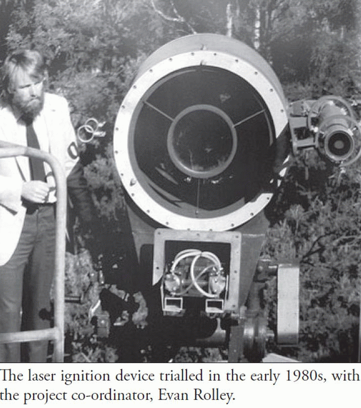
Jim Hickman, a Fire Management Officer from Tasmania, first suggested using lasers for slash burning in the late 1960s.
Inspired by US weapons research, Forestry Tasmania wanted to ignite logging slash from 4 to 5 km away. The idea was further promoted by Phil Shepherd in a series of reports in 1973.
In 1975, Phil Gourlay from Forestry Tasmania, working with Dr Mark Waterworth from the Physics Department at the University of Tasmania, began a joint research project to develop the idea. In 1977, Evan Rolley took-over from Phil as coordinator.
Experiments were conducted between 1979 and 1981, using a weapons-grade laser mounted on a Royal Australian Navy Bofors 40 mm anti-aircraft gun. It had taken two years of paperwork and intergovernmental diplomacy to get clearance from the Navy to release the weapon.
But there were several problems in getting the laser to work effectively in the bush. The mirrors were gold plated and required very skilful polishing. It also required a very stable platform and the mirrors to be precisely aligned to concentrate sufficient power at one point to ignite logging slash from a considerable distance.
The laser had varied success at igniting canvas targets at distances between 200 m and 500 m, but after further research by Nick Gellie the project was discontinued in 1983.
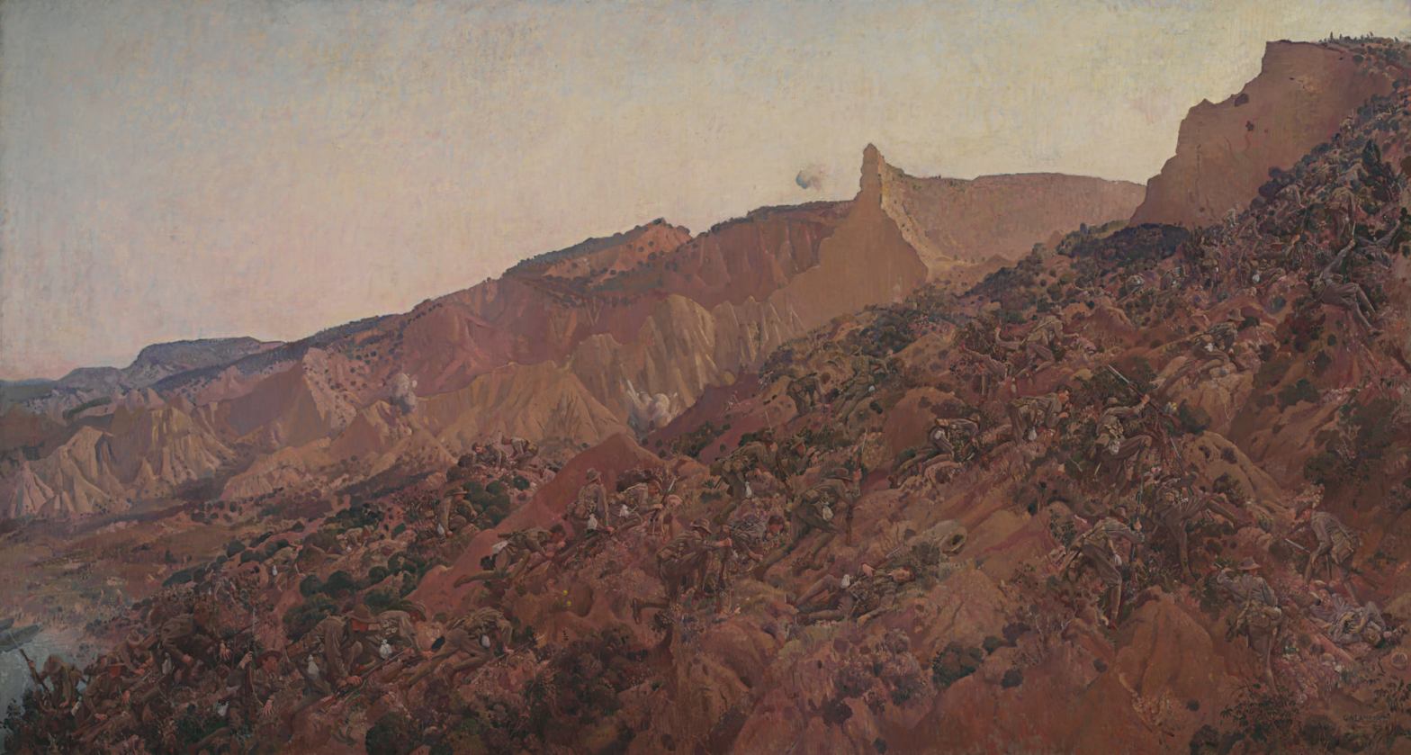
Most Australians would have heard the legendary story of the solitary Turkish Pine (Pinus brutia) that grew on the slopes of the Gallipoli Peninsula made famous as marking the site of the Battle of Lone Pine in August 1915.
But few may have heard about the Gallipoli Oak (Quercus coccifera subsp. Calliprinos) that grew along the ridges and valleys.
Also sometimes known as Palestine Oaks, these trees grow to about five metres tall, and have evergreen and prickly serrated leaves similar to a holly.
A specimen known as the Oak of Mamre, is believed to have survived for 850 years.
But when heavily grazed by goats they only grow between 1 and 3 metres and look more like a bush than a tree.
General John Monash wrote home to his wife in November 1915:
“I am sending in a separate packet, a few acorns. I have made the discovery that the prickly scrub, with which these hills are covered, and which has inflicted many an unkind scratch on hands, arms and bare knees, is really a species of holly, and bears an acorn, showing that it belongs to the Oak variety. The bush is quite ornate and grows to a height of about 5 feet, much like the ordinary holly with the red berry.”
Monash was not the only soldier to collect specimens and send them home.
Captain William Lempriere Winter-Cooke also collected acorns which were planted in 1916 by his family at their historic home, “Murndal”, near Hamilton.
Acorns were also planted at Geelong Grammar where Captain Winter-Cooke went to school, and together with the tree at Murndal, they are the only mature specimens in Australia.
While not as well known as the Lone Pine, the Gallipoli Oak is also an enduring arboreal link to Anzac cove.
This famous painting by George Lambert shows the sort of terrain on Anzac Cove where the prickly Gallipoli Oak grew. Source: NGAGallipoli Oak at Murndal. Source: Oak SocietyGallipoli Oak. Source: Oak SocietyCaptain William Lempriere Winter-Cooke. Source: National TrustMurndal. Source: State LibraryGallipoli Oak planted at the Melbourne Shrine as the AE2 Remembrance Tree. Source: The Gallipoli Oaks Project.Geelong Grammar. Source: National Trust
On ANZAC Day we gather to remember those who served our country. We may attend a dawn service, go to a march, wear some precious family medals, or lay a wreath at a cenotaph. We may even follow with a cold frothy or two and a game of two-up at our local RSL.
But across Australia there are many silent and enduring war memorials we may pass every day, often without realising their significance.
Avenues of Honour might be trees lining a road or street, along a path through a park, or a magnificent lone specimen.
During and after World War One, these arboreal tributes were particularly popular, with some 325 planted throughout Victoria alone.
The Australian Government did not repatriate bodies of soldiers after the war so a tree, close to the family home or town, became an important way of remembrance.
But as the years wore on, many Avenues of Honour aged and declined, or sometimes disappeared completely. Some lost so many trees they were no longer recognisable.
In 2000, fewer than 200 Avenues of Honour were recorded across Australia – mostly in Victoria. In 2004 a non-profit organisation, TREENET, launched a program to document, preserve, promote and even reinstate the original Avenues of Honour.
Victoria’s best-known Avenues are probably at Bacchus Marsh and Ballarat.
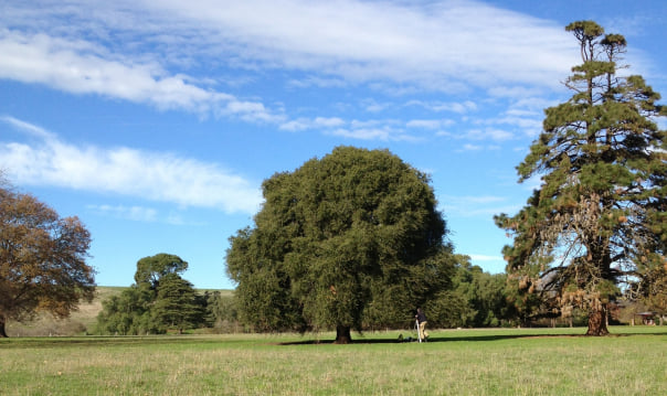
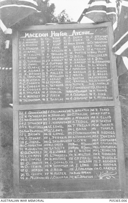
But there is another significant Avenue of Honour at Macedon with 154 Scarlet Oaks* (Quercus coccinea), plus one English Oak (Quercus robur) at the abutting ends of each row.
The trees were planted 40 feet apart over half a mile stretch of road with funds raised by the community. The Avenue was opened by the Premier of Victoria, Harry Lawson, on 10 August 1918 at a ceremony attended by some 700 people, two months before the War ended.
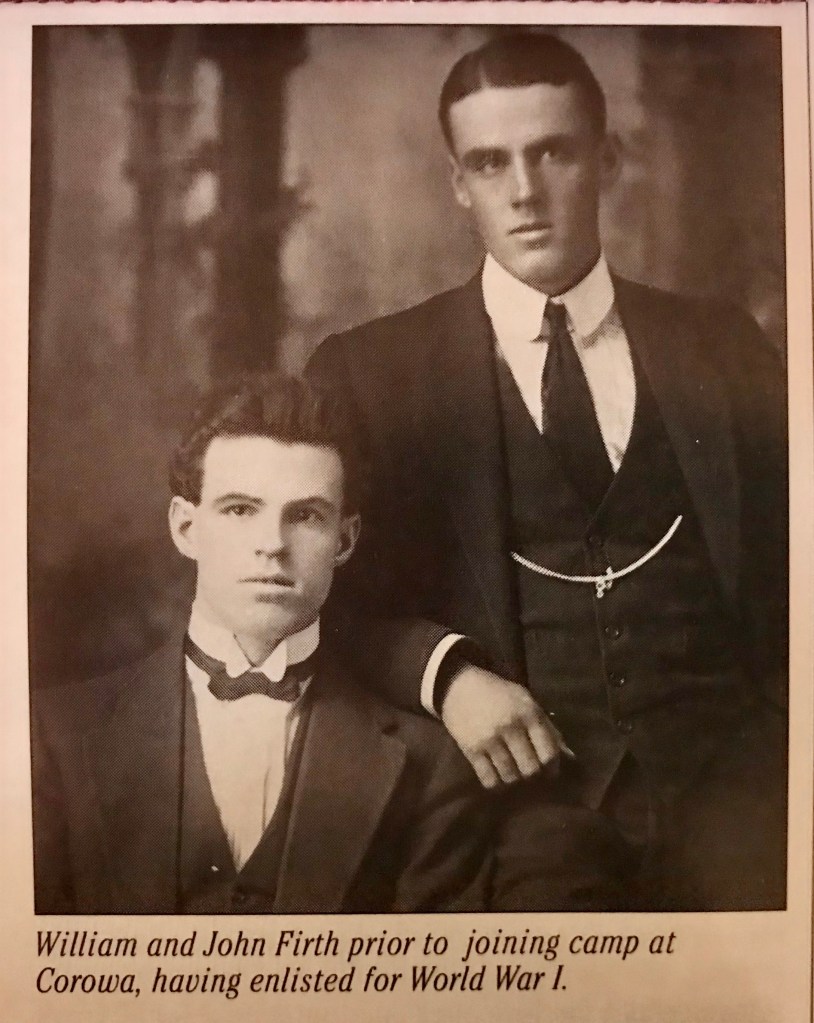
Two of the commemorative trees were planted to recognise John Firth (tree # 39) and his younger brother William Firth (tree #139), who both served in the AIF. They were the sons of Joseph Firth, the well-regarded Superintendent of the Macedon State Nursery. It is also believed that Joseph raised and supplied the trees.
The Macedon Avenue of Honour was partially damaged in the 1983 Ash Wednesday bushfire but remains magnificent in autumn. It is listed on the Victorian Heritage Register.
Joseph Firth was born in the Orkney Islands in Scotland on 12 August 1854 and emigrated to Australia in 1872 when he was just 17.
Joseph married Mary Ridden and arrived at Mount Macedon to begin a lifelong and distinguished career in horticulture, firstly as gardener at Glencairn and later at Government Cottage.
In 1885, Joseph took a position as curator at the Macedon State Nursery and, by 1891, rose to Superintendent upon the retirement of Victoria’s first “Overseer of Forests and Crown Land Bailiff”, and founder of the nursery in 1872, William Ferguson.
In addition to producing millions of trees, Joseph built the nursery into a widely acclaimed showcase for the Forests Commission Victoria (FCV) with an ornamental lake, walking paths, landscaped gardens and a large arboretum with many unique exotic trees.
Joseph’s first child, James, was later to become a trainee forester at Macedon Nursey, like many others before him, and in 1913 was appointed Officer in Charge of Briagolong District. James rose to Inspector of Forests in East Gippsland and at one time acting Commissioner in Melbourne.
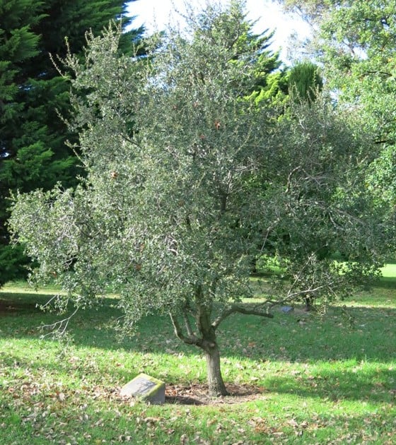
In 1890, Joseph selected 240 acres in the nearby Wombat State forest about 12 miles from Macedon and near Trentham which he intended to use for grazing. He built a house and dam and took his family there on weekends and holidays. He also planted large numbers of experimental plots of trees, including many types of oaks including the Macedon Oak, Quercus firthii, which was named after him. A eucalyptus oil still was also built. After his death the land was sold back to the government and is now known as Firth Park.
On 30 December 1921 Joseph, aged 67, fell from his horse and died soon after.
There is little doubt that Joseph Firth left a lasting legacy towards the “greening” of Victoria, at a time when the State Government was still encouraging the clearing of forest and public land for land settlement.
There was probably not a school or public garden in Victoria which did not contain trees from Macedon over which Joseph Firth had personally watched with fostering care and interest.
However, the 1983 Ash Wednesday bushfires severely impacted the State Nursery when vehicles, buildings and thousands of nursery seedlings were lost. Many of the historically significant trees in the grounds of the nursery were also killed.
The Macedon nursery was eventually rebuilt with a new office and handsome interpretive centre and opened by Joan Kirner in August 1987, but a rationalisation by the Department of Conservation, Forests and Lands (CFL) of all its nurseries in the 1990s eventually led to it being privatised and sold.
All that now appears to remain of the once magnificent State nursery established by Joseph Firth are a grove of Cork Oaks, a few remnant conifers and European trees, the overgrown lake with some old pathways, as well as a rather sad looking Italianate fountain which dates from 1895.
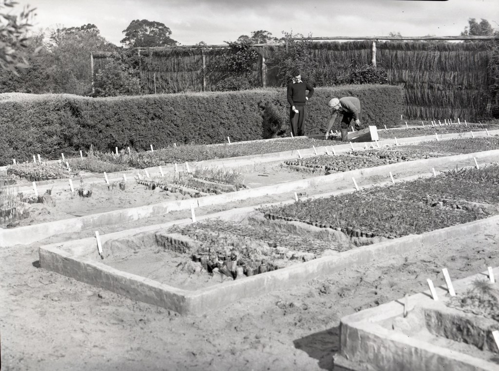
In the 1930s, the Forests Commission took a leading role in stabilising soils in the desert country of northwest Victoria ravaged by drought and excessive clearing of Mallee woodlands for farming.
Revegetation works by the Commission using Cypress Pine were carried out in the dry Hattah – Kulkyne forests in 1937-38 but it was severely hampered by large rabbit populations and the vagaries of the weather.
It wasn’t until November 1940 that an Act of Parliament created the Soil Conservation Board that eventually became the Soil Conservation Authority (SCA).
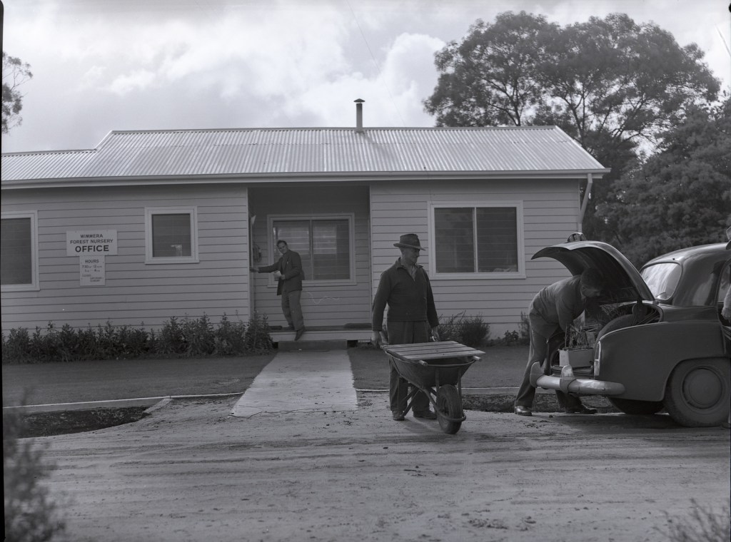
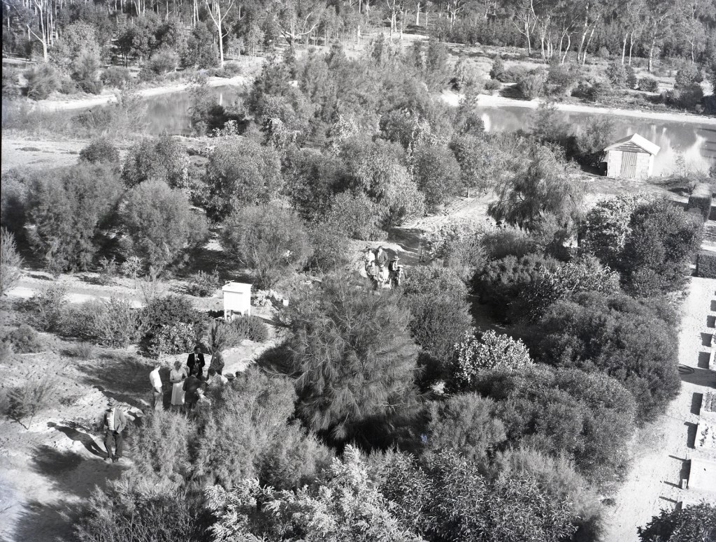
In 1946 the Commission established the Wail Nursery near Horsham with noble goals of improving forests, protecting them from bushfire and growing trees to restore farmland. The nursery focused on propagation of species suitable for the drier areas of the State.
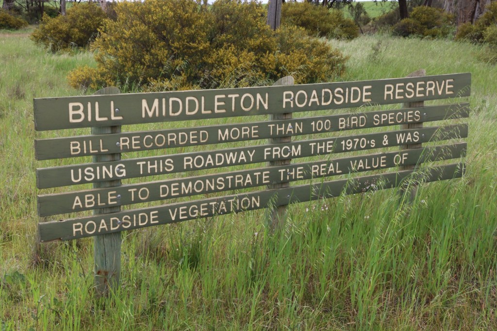
One of the many quiet achievers was Bill Middleton, the District Forester at Wail between 1959 and 1976.
Behind the scenes, Bill quietly influenced the State Government’s change of mind over its controversial proposal to clear the Little Desert for agriculture in the late 1960s.
From the mid-1970s Bill was instrumental, along with the Institute of Foresters (IFA) and the Forests Commission, in tackling rural tree decline and helped initiate the successful “trees on farms” program. This became the precursor to Landcare which was announced in 1986 by then Victorian Minister for Conservation, Joan Kirner. But that’s another story.
Bill also worked for many years, largely through the Trust for Nature and the Potter Foundation, for the preservation of native vegetation and bird habitat.
Bill broadcast regularly on ABC Wimmera Radio about gardens, birds and natural history as well as did television appearances. He was awarded an OAM in 1999 for service to conservation, the environment and land management.
A rationalisation by the Department of Conservation, Forests and Lands (CFL) of all its nurseries in the 1990s led to Wail being privatised and sold. From 2017 it has operated as the Dalki Garringa Native Nursery.
Mrs. Dunn and her son Colin cross a barren and dusty paddock in the Wimmera during the 1944 drought. Source: State Library.Revegetation works using Cypress Pine were carried out in the dry Hattah – Kulkyne forests in 1937-38 but this work was severely hampered by large rabbit populations and the vagaries of the weather.The Institute of Foresters and the Forests Commission became very concerned about rural tree decline from the mid-1970s and initiated the “trees on farms” program. This became the precursor to Landcare which was announced in 1986 by then Victorian Minister for Conservation, Joan Kirner.Five Chain Road west of the Dimboola-Rainbow Road about 8 kilometres north of Dimboola.
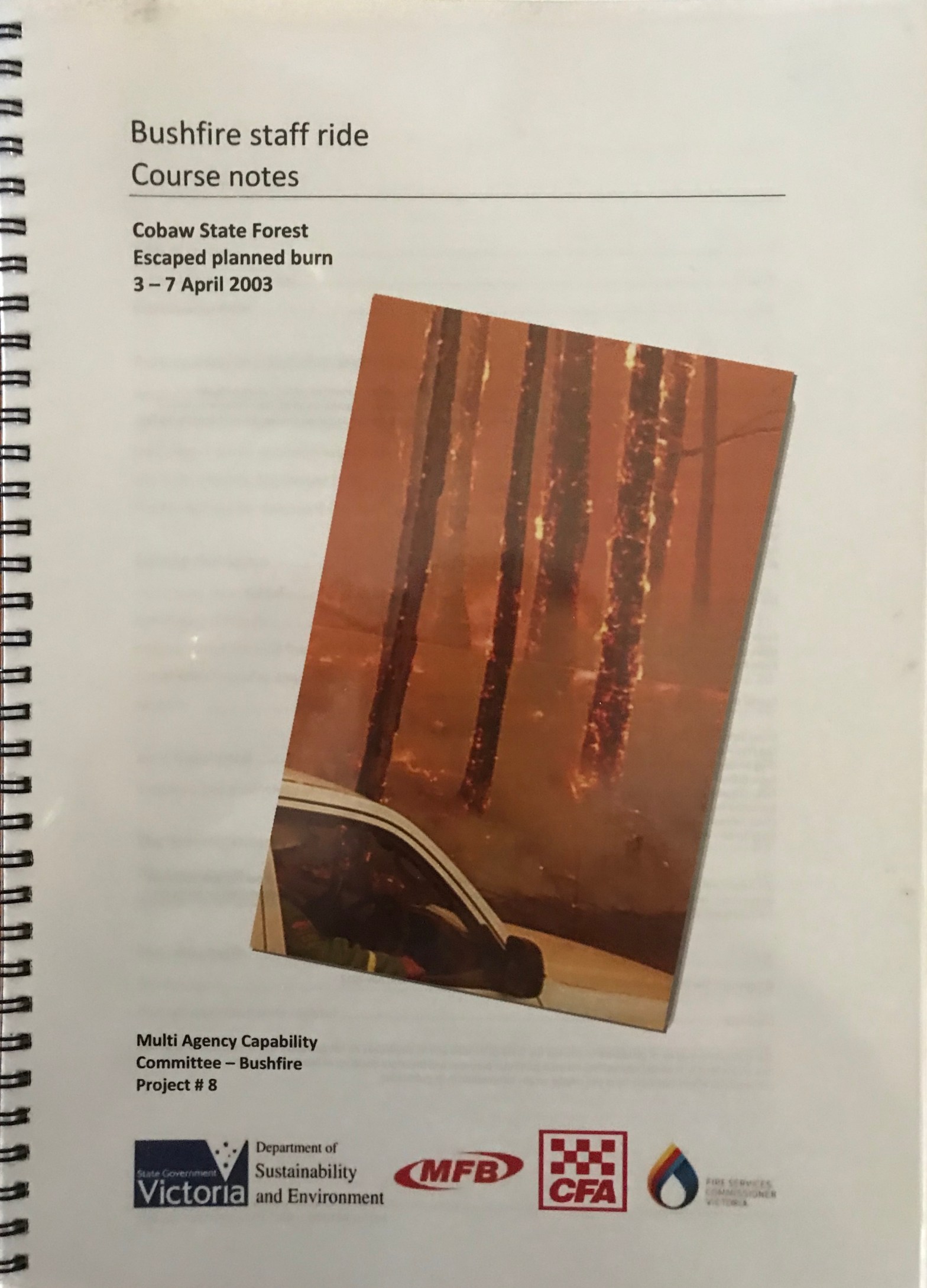
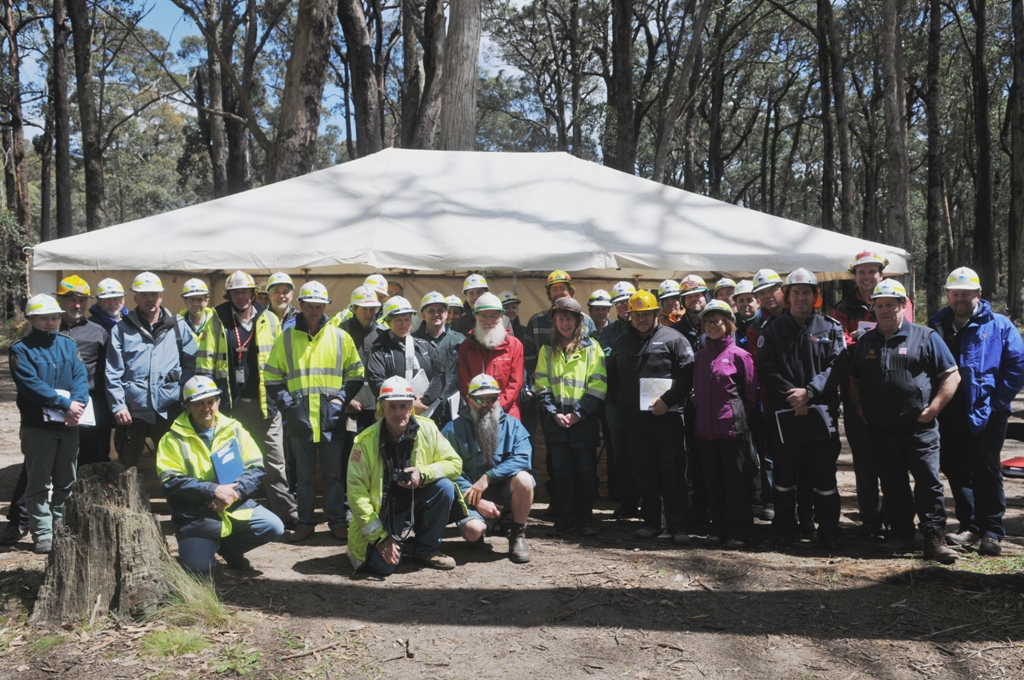
Staff Rides can trace their origins back to the Prussian Army after the Napoleonic Wars. They were adapted by the US military and then more recently by many American fire agencies. They are now considered an essential technique to develop senior leadership skills.
The Cobaw Bushfire Staff Ride in 2011 was the first attempt in Victoria. Another followed at Linton in 2014.
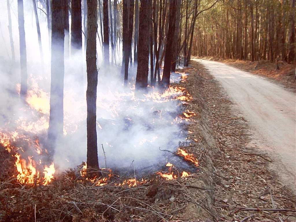
The escape of a Fuel Reduction Burn (FRB) from the Cobaw State forest 20 years ago during early April 2003 couldn’t have happened at a worse time.
The escape was against the backdrop of the huge alpine fires in Victoria and NSW together with the loss of some 500 homes and four lives in Canberra. People were angry and several state and federal government inquiries were announced.
On the face of it, the FRB at Cobaw seemed simple and routine but in fact proved very complex. There was no “right” answer, and the “truth” may never be fully known.
The Cobaw Staff Ride consisted of three distinct phases:
Preliminary Reading about the bushfire event, often weeks before the staff ride, involving forensic study of investigation reports, individual biographies, first-hand accounts, weather information, maps, photos, logs, media reports etc.
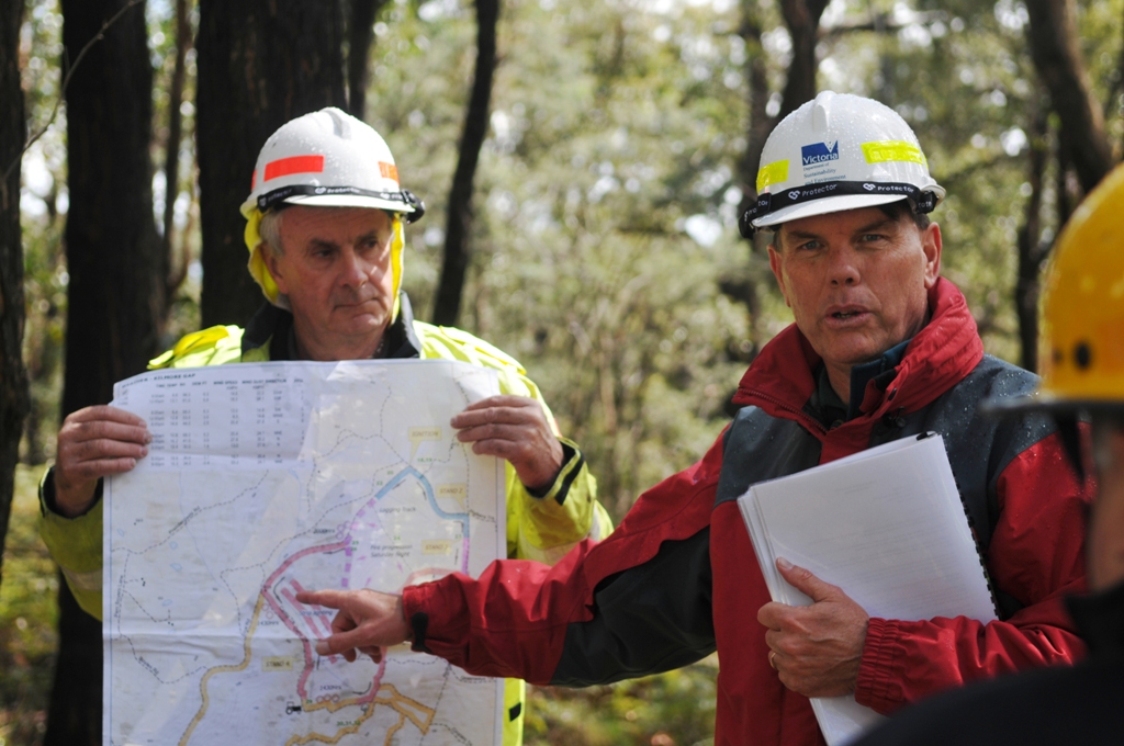
Field Study walking across the fire ground in small groups with a facilitator to understand the unfolding story from the perspective of people actually involved and discuss major assumptions, events and critical decision points.
Integration Phase to share impressions and lessons learned with other participants.
The Cobaw Bushfire staff ride presented a unique opportunity to learn from a past incident and was not about blame. The best decision maker, even taking all reasonable steps and precautions will still make misjudgements.
Every firefighter will know that bushfires are a dynamic and complex environment, and every decision made in real time is imperfect. The Staff Ride:
provided a chance to learn from low frequency but high-risk events.
gave an opportunity to analyse the key decisions and assumptions together with a study of the actual terrain and to demonstrate the effects of weather, slope, topography and fuels upon the fire.
focused on leadership, communications, decision making, biases and human factors.
encouraged discussion and debate between participants.
Bushfire staff rides are a powerful form of experiential learning because participants can see, hear and feel the environment where the decisions took place. Firefighting is often characterised by:
rapidly changing circumstances.
risky and sometimes life-threatening situations.
ambiguous instructions and objectives.
limited time for analysis, reflection and consultation.
failure to communicate clearly, or at all.
lack of adequate fire ground intelligence.
lost opportunities caused by failing to act quickly or seize the initiative.
lack of situational awareness.
over / under estimation of people’s capabilities.
“Staff Rides are told as stories and experiences”.
When constructed like stories with beginnings, middles and ends, bushfire staff-rides can be a profound method of learning.
Unlike many bushfire training exercises, (or worse still death by PowerPoint), with their often-rigid outline of facts and statistics (including the presumption that all the “facts” are known, the behaviour of the fire was inevitable, and could have been predicted), a bushfire staff ride, constructed like a story, places the same fire event using the same facts and statistics into a storyline with a strong narrative structure.
People involved with the bushfire tell, in their own voices, using their own words, the story of what happened to them.
Stories can more easily deal with ambiguity and the “fog of battle” that is so common to bushfires. Within the framework of a staff ride story, a bushfire event becomes more intricate and complex.
The outcome of bushfires or planned burns is rarely the result of a single decision made by one person. It is usually the result of many decisions made in an environment of competing demands, incomplete information, and pressures of time.
Participants were challenged to push past the basic questions of what happened. And unlike a simple historical tour they got to stand on the actual fire ground for themselves and “walk in the shoes of others”, then consider through a series of challenging tactical decision exercises what they would do in the same situation.
For many course participants it proved very uncomfortable and confronting to shift from their initial standpoint of “what the hell were they thinking”, to then realise that they probably would have done exactly the same things and made exactly the same decisions.
This shock realisation was often accompanied with a lot of “feet shuffling” and “hand wringing” and common blame shifting phrases such as … would’a… should’a… could’a…
But as I often used to say, “nobody sets out to have a bad day” and “everything seems inevitable in hindsight”.
The Cobaw Staff Ride ran successfully from 2011 for several years for many hundreds of participants but ceased after the Lancefield escaped burn under similar circumstances in October 2015. The independent review of Lancefield noted the importance of the Cobaw Staff Ride and recommended it continue.
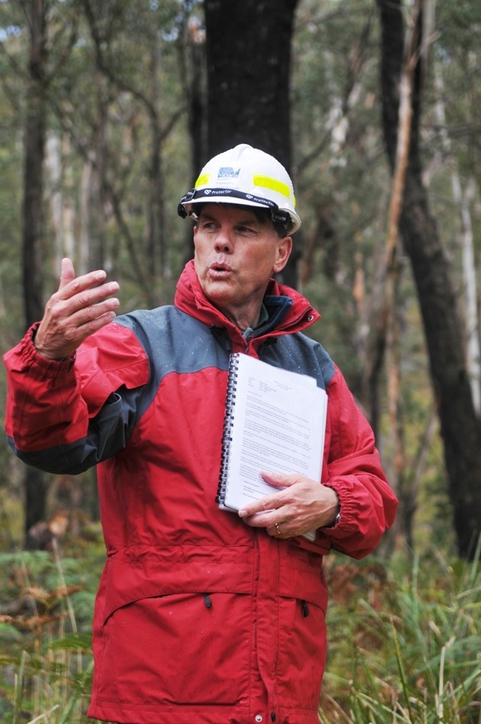
The career of Lee Gleeson, the experienced Fire Management Officer from Bacchus Marsh, was a significant casualty of the Cobaw and Lancefield burn escapes. More importantly, Lee deserves to be commended for his willingness to share his story so that others may learn.
The Cobaw Staff Ride was evaluated by the Bushfire CRC and also won the prestigious Victorian Fire Services Award in 2012.
This was followed by an invitation from the US Forest Service in 2014 to be a participant/instructor in their senior level fire leadership course, which was run by the US Marines, and which examined the lessons learned from the Battle of Gettysburg in 1863. The invitation also stretched to the South Canyon Staff Ride in Colorado where in 1994 fourteen USFS smokejumpers and hotshots died when a fire overran them.
“If you want a new idea, read an old book” – Ivan Pavlov.
The summer of 2002-03 had been one of the largest and most prolonged fire seasons for many years. Huge bushfires spread across the Victorian Alps, NSW and even into some Canberra suburbs where four people died and over 500 homes were lost.
People and communities were angry and several state and federal government inquiries were announced.
Many bushfire “experts” were running commentary in the press with renewed allegations that a lack of Fuel Reduction Burning (FRB) on public land had contributed to the extent of the summer bushfires.
In the first week of April 2003 the Department of Sustainability and Environment (DSE) had conducted 59 FRBs across the State, all without incident.
Most firefighters were becoming fatigued, and the summer crews were nearing the end of their annual employment contracts.
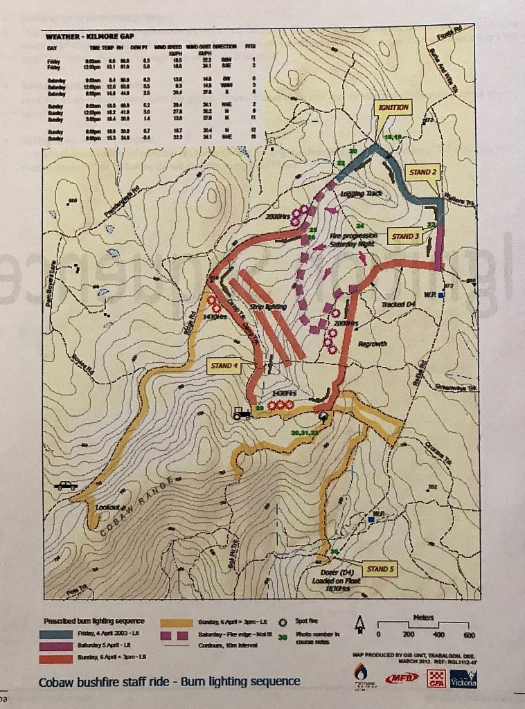
It was against this backdrop that on Friday morning, 4 April 2003, staff from DSE together with colleagues from Parks Victoria (PV), ignited an approved 650 ha Fuel Reduction Burn in the Cobaw State forest north of the Macedon Ranges.
The burn was planned and led by an experienced Fire Management Officer (FMO) from Bacchus Marsh.
The weather pattern was leading into a typical autumn drying cycle and was within prescriptions. Most of the area hadn’t been burnt since 1965 and the ground and elevated fuels were at extreme levels. The thick stringybark on the messmate trees (E. obliqua) presented a particular hazard.
The local CFA brigades were notified, but it was not customary for them to participate in routine burns on State forest.
A test burn was lit at 09.30 am and ignition was attempted throughout Friday morning but was terminated around midday because of the slow progress and damp fine fuels from a shower of rain earlier in the week. However, the underlying soil and fuel dryness was still high with a Kettch-Byram Drought Index well above 100.
The DSE and PV crews returned home in the late afternoon and patrols were arranged over the weekend with an intention of returning early on Monday morning to complete the job.
It was not uncommon to leave Fuel Reduction Burns unattended overnight, particularly if they were within containment lines and during autumn when the nights were cool and followed by a morning dew. This conserved crews for daylight work when they could be more effective.
On Saturday morning around 10.00 am an experienced Park Ranger from Macedon went on patrol as planned. Also rostered that weekend were the Fire Duty Officers at Bacchus Marsh and Ballarat that took responsibility for coordination of burns across the region.
The burn had continued to trickle slowly over Friday night but remained sluggish, so efforts were made during Saturday morning to consolidate boundaries and bring the burnt edge out to containment lines and roads.
Forest fuels have a long residual burning time and don’t extinguish quickly or easily like grass. This adds considerably to the complexity and length of the firefighting effort, particularly patrol and blackout.
The fire behaviour escalated steadily throughout Saturday afternoon with some flare ups and spotting around 6.30 pm as the fuels dried out. But as expected, the fire quietened down again later in the evening.
However, because of the fire behaviour on Saturday, additional crews and bulldozers were deployed early on Sunday 6 April to cut-off the fire boundary on Camp Track.
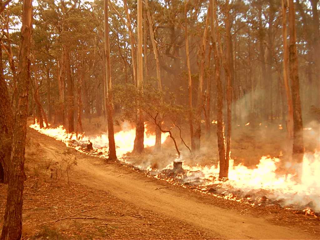
But by mid-afternoon the weather worsened, and the fire spotted over Camp Track and threatened the safety of a D4 bulldozer operator.
The fire behaviour then intensified with high rates of spread and flames climbing into the tree crowns. The smoke column, measure by the radar at Tullamarine airport, reached 4000 m.
At the same time as the spot over of Camp Track an empty parked car was discovered on Ridge Road and two hikers were believed to have made their way to an old lookout which was in the direct path of the fire. Crews were deployed to find the couple without success so backburning was commenced to stop the spread of the fire towards the lookout area.
Despite all the fire activity during the afternoon the fire was still within the original planned containment lines at 7.30 pm on Sunday evening, and fire behaviour quiet, when all crews left the bush.
The experienced Officer In Charge reasonably believed that the fire would once again die down overnight and intended to return with a full complement of vehicles and crew on Monday to complete the task.
But during the middle of the night the fire unexpectedly began to spread downhill over two kilometres under the influence of northerly winds and a dry air mass sitting at altitude above the fire.
Surprisingly, the Cobaw State forest sits up high at an elevation of 650 m, which was above the temperature inversion layer that developed on Sunday night. This meant that the bush remained dry and warm while the paddocks and nearby farms on the lower flats received fog and a light dew.
The fire was reported in private property at 05.00 hrs on Monday morning 7 April 2003 and a joint DSE/CFA incident management team was deployed to control the escape.
The 1339 ha fire burnt 360 ha of private property to the south causing slight damage, but also threatened some houses. It took months to rebuild fences and settle all compensation the claims with landholders.
There was considerable criticism of DSE by media commentators, armchair experts and the local community. Disappointingly, some other firefighters joined the noisy chorus while the smoke was still swirling and before the investigation had even begun.
Two internal reviews were conducted leading to some changes to procedures. Importantly, the Chief Fire Officer Gary Morgan, apologised to the community but remained resolute in his support for the staff and crews.
It was found that the main things that contributed to the escape were the complexities of the site and seasonal conditions, the underlying drought, the heavy fuels, particularly the messmate bark. Lighting over three days was not originally planned so crews became caught up in a rapidly drying cycle that saw the fire intensity increase more than expected. Not being able to cut the burn off at Camp Track, the two hikers and the unanticipated temperature inversion of Sunday night played a big role. Not having enough crews to leave online overnight to patrol was also a significant factor.
Fuel Reduction Burning is inherently risky and requires great skill and courage, as well as a generous dollop of good fortune, to execute successfully.
It’s one thing to be an outside observer, or even a firefighter holding a drip torch, but quite another to plan a FRB and approve “dropping the match” and then take full responsibility for its success, or failure.
The escape at Cobaw later became the subject of a senior fire leadership training program called a Staff Ride.
Top Photo: The fire escaped after it crossed Camp Track on Sunday afternoon. Photo: Lee Gleeson
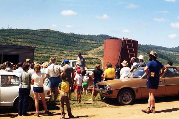
Forestours were launched by the Forests Commission Victoria (FCV) at Lakes Entrance in January 1977.
A brainwave of Bairnsdale forester David Buntine, Forestours got their inspiration from the NSW Forestry Commission on the south coast which offered free self-drive, or tag-along tours on mostly gravel roads in State forest under the guidance of local forestry staff.
The first tours began on Wednesday 12 January 1977 when 49 cars with 172 people booked into one of the four tours available on the day.
In an era before mobile phones, the internet and social media, Forestours were promoted by the local newspaper, flyers in motels, the tourist bureau and word of mouth.
Tours were held again over the next four weeks for a total of about 850 visitors.
The tours visited the nearby Colquhoun State forest and included sleeper cutting with swing saws and broad axes. They also inspected logging coupes and Jack Ramsdell’s sawmill at Nowa Nowa, as well as the nearby FCV fire tower.
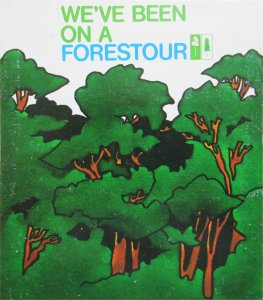
The tours concluded at the Mississippi Creek picnic ground where people often lingered and chatted with staff. The kids loved being fitted with a hard hat, and many of the adults too for that matter, while the Forest Environment and Recreation (FEAR) Branch provided special “We’ve been on a Forestour” stickers to put on the cars.
There were additional guided bushwalks with forester and naturalist Peter Fagg near Lake Tyers.
Forestours were judged a success and spread from Lakes Entrance to Marlo in January 1978, and then to other centres across the State including Toolangi, Upper Yarra, Healesville, Tallangatta, Corryong, Bright, Heywood and the Otways.
Forestours were generally offered at summer holiday locations where visitors were often looking for alternative things to do, particularly if they were free, short duration, family friendly and involved something new or interesting.
Many local FCV staff were willingly recruited as guides and found the experiences to be friendly, rewarding and worthwhile.
The FCV annual report of 1983-84 noted a total of 50 Forestours, 70 spotlight walks of the forest by night, and forest excursions for 500 schools and 100 other groups.
But sadly, Forestours fizzled out in the mid-1980s with the new Department of Conservation Forest and Lands.
Ray McCrae at the Forestour assembly point – Lakes Entrance, 1977. Photo: David BuntinePBrian Fry at the Forestour assembly point – Lakes Entrance, 1977. Photo: David BuntineForestour at Ramsdell’s Sawmill – Nowa Nowa, 1977. Photo: David Buntineorestour nature walk conducted by Peter Fagg Denis Read left of centre, 1978. Photo Peter FaggDavid Buntine with Forestour group at Shelley Firembombing Base, 1981. Photo: David BuntineFCV Annual Report 1976/77
Forest Environment and Recreation (FEAR) Branch provided car stickers. Source: FCRPA
Today is World Forestry Day (WFD) which was proclaimed by the United Nations Food and Agriculture Organisation over 50 years ago in 1971.
It was set down for 21 March each year to coincide with the vernal equinox when the sun passes over the equator giving equal lengths of day and night.
It also marks the first day of spring in the northern hemisphere and autumn down under.
For many years Forests Management staff celebrated by staging a diverse and innovative range of community events.
Sadly, the occasion has become a bit lost and forgotten in amongst a modern and cluttered calendar full of sometimes bizarre commemorative days complete with different coloured ribbons for this-n-that.
WFD was rebadged “International Day of Forests” by the UN in 2012 but still recognises the essential importance of our forests.
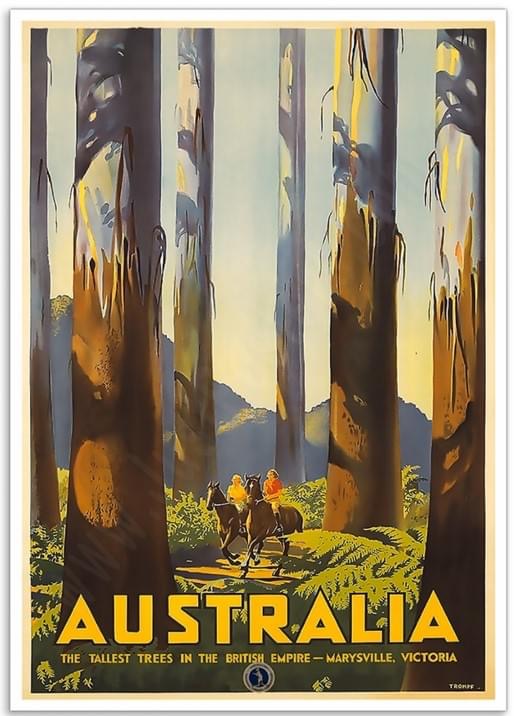
Poster: The Tallest Trees in the British Empire. Marysville, Victoria. By Percy Trompf (1936). Australian National Travel Association. National Library of Australia.