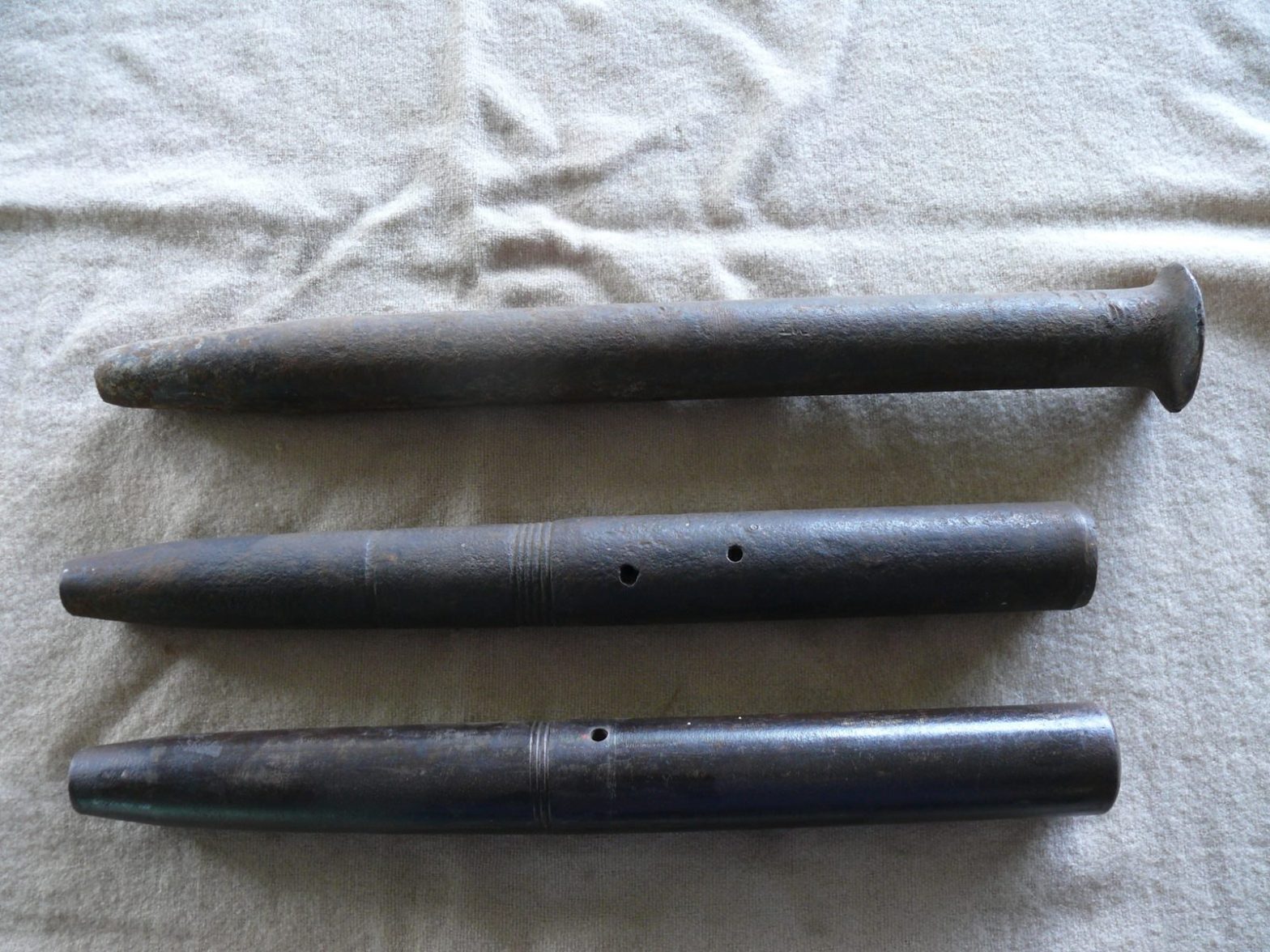
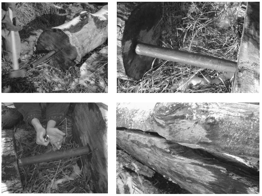
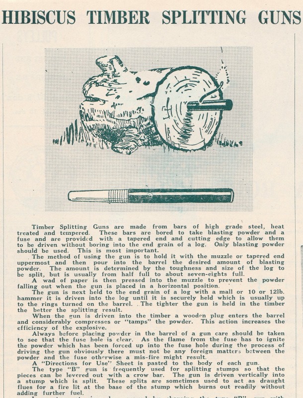
Black powder splitting guns were commonly used to split large logs into more manageable pieces before the advent of excavators and front-end loaders in bush logging operations.
A typical splitting gun used in Victorian forests was a piece of high-grade steel about 1-1/2 to 2 inches in diameter and about 16 inches long, and slightly tapered at one end.
They had a ¾ inch hole drilled about 9 inches deep into the centre of the shaft with a small pilot hole drilled from the outside to load the fuse.
The tube was carefully loaded with an amount of black gunpowder using a funnel and spoon. Experience being the guide on how much powder to use, which depended on log size, species and difficulty of splitting the wood.
The hole was stopped with a piece of wadded paper and the gun positioned at the end of a length of the log to be split.
The splitting gun was then belted into the log with a large wooden maul or even the back of an axe to a depth of about 3 to 4 inches. There were often markings as a guide. This also had the effect of tamping the black powder inside the gun.
Preferably the gun was backed up by another large log to absorb the shock and avoid it flying off in the bush somewhere. I have seen guns where a length of string and coloured flag could be attached to help find them.
A length of fuse was then inserted in the small hole and lit. Kaboom !!!!
Needless to say, the splitting gun was a dangerous implement.
Mechanical pulp splitters at a landing off the old Cowwarr Road in the Boola Boola forest in 1964. This was the first attempt at a mobile splitter to replace the black powder splitting gun. Photo: Brian Fry.
It’s often said that mountain ash, Eucalyptus regnans, is the world’s tallest flowering plant, and possibly the tallest plant of all time, although no living specimens can make that claim.
Tree height is influenced by species, genetics, age, stand density, soil type and depth, rainfall, aspect, altitude, protection from wind and snow damage, fire history and insect attack.
Tree scientists believe that trees have a theoretical maximum height of 430 feet (130 m) even though there are many historical claims of taller trees.
The main physiological factor limiting tree height is its ability to suck a continuous column of water up against the forces of gravity. The crowns of the tallest trees need to lift sap more than 10 times the surrounding atmospheric pressure by combining the complex physics of capillary action and leaf transpiration. Contrary to popular belief, tree roots do not pump water although root pressure is a factor.
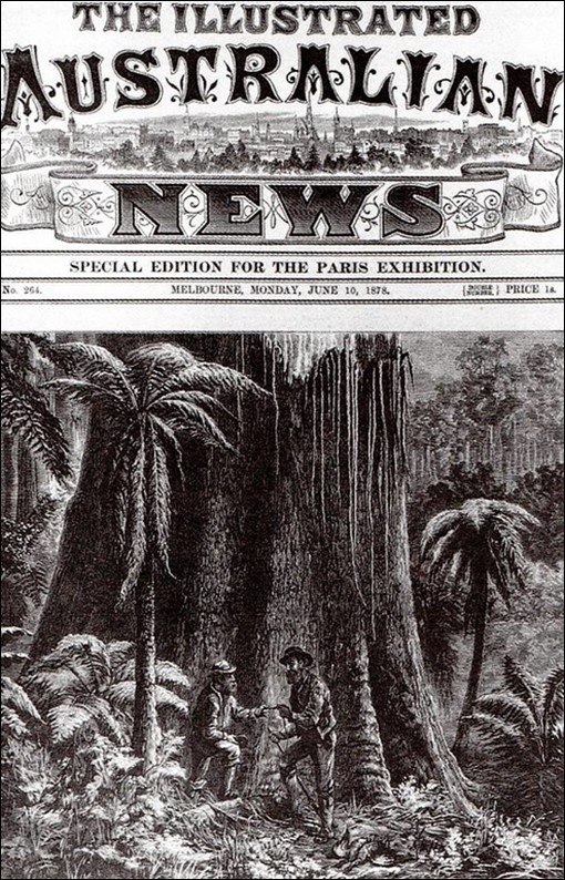
As early as 1866 Baron Ferdinand Von Mueller, the Victorian Government botanist, published some astonishing, and probably exaggerated, claims of a mountain ashon the Black Spur near Healesville being 480 feet high.
There were similar reports from nurseryman David Boyle and others of trees in the Yarra Valley, Otways and Dandenong Ranges reaching “half a thousand feet”.
Doyle was later savagely criticised by Melbourne newspapers in 1889 about a tree he had named “The Baron” in homage to his friend von Mueller.
The tree was growing at Sassafras Gully in the Dandenong Ranges and Doyle said he had initially measured it in 1879 at 522 feet tall. It was later remeasured for the Melbourne exhibition in 1888 where it had reduced in size to 466 feet. However, when properly measured by Commissioner Perrin from the Forest Department and surveyor Mr Fuller from the Water Supply Dept in 1889, it was found to be only 219 feet 9 inches – a somewhat catastrophic reduction in height to less than half of that originally claimed. Its girth had also inexplicitly shrunk from 114 feet to 48 feet. Poor measurement techniques in thick scrub probably being the most generous explanation of their dimensional discrepancies.
William Ferguson, the State Government’s first “Overseer of Forests and Crown Land Bailiff” wrote to the Assistant Commissioner of Crown Lands, Clement Hodgkinson in 1872 reporting trees in great number and exceptional size in the Watts River catchment but his account is often disputed as unreliable.
“Some places, where the trees are fewer and at a lower altitude, the timber is much larger in diameter, averaging from 6 to 10 feet and frequently trees to 15 feet in diameter are met with on alluvial flats near the river. These trees average about ten per acre: their size, sometimes, is enormous. Many of the trees that have fallen by decay and by bush fires measure 350 feet in length, with girth in proportion. In one instance I measured with the tape line one huge specimen that lay prostrate across a tributary of the Watts and found it to be 435 feet from the roots to the top of its trunk. At 5 feet from the ground, it measures 18 feet in diameter. At the extreme end where it has broken in its fall, it (the trunk) is 3 feet in diameter. This tree has been much burnt by fire, and I fully believe that before it fell it must have been more than 500 feet high. As it now lies it forms a complete bridge across a narrow ravine” …. William Ferguson, The Melbourne Age, February 1872.
The Victorian public remained fascinated by large trees and to celebrate the Melbourne Centennial Exhibition in 1888 offered a reward for the tallest tree. Parliamentarian and exhibition organiser, James Munro personally offered an additional £100 for anyone who could locate a tree taller than 400 feet. No such tree was ever found but there were issues with the time allotted for the survey.
The tallest tree reliably measured for the 1888 Exhibition was the “New Turkey Tree” near Noojee at 326 feet 1 inch.
In 1976, a monument was unveiled by the Hon Jim Balfour to the “World’s Tallest Tree” near Thorpdale which, in 1884, was measured twice by a surveyor George Cornthwaite at 375 feet, once in the upright position, and again after it had been chopped down. This account was reported in the Victorian Field Naturalist many years later in July 1918 but is often considered the most reliable record of Victoria’s tallest tree.
The Chairman of the Forests Commission, Alfred Vernon Galbraith studied mountain ash for his Diploma of Forestry and wrote in 1937 that “they can make serious claims to be the world’s highest tree”. His successor, Finton Gerraty personally measured a fallen tree near Noojee after the 1939 bushfires at 338 feet and with “its top tantalisingly broken off”.
Recent measurements between 2000 and 2002 of over 200 of Victoria’s trees found the tallest specimen of mountain ash was inside the Wallaby Creek Catchment near Kinglake being over 300 years old and 301 feet (92 m) high. The height was accurately determined using a ground-based laser rangefinder and then verified by a tree climber with a tapeline, however the tree later perished along with 15 other tall trees during the 2009 Black Saturday bushfires.
The tallest regrowth mountain ash in Victoria is currently named “Slinky Sloan in the Upper Yarra at 305 feet (93 m).
Australia’s tallest measured living specimen is named Centurion and stands at 330 feet (100.5 m) in Tasmania. However, I’m aware surveys are underway, and this may have changed.
Whether a mountain ash over 400 feet high ever existed in Victoria is now almost impossible to substantiate but the early accounts from the 1860s are still quoted in contemporary texts such as the Guinness Book of Records and Al Carder as well as being widely restated on the internet.
Currently the world’s tallest living tree is a Coast Redwood, Sequoia sempervirens, named the Hyperion, discovered in California in 2006. It is believed to be between 700 and 800 years old and was measured at 380.3 feet (116 m).
Photo: This mountain ash from Fernshaw featured on the cover of the Illustrated Australian News of June 10th, 1878. Unofficial measurements were 430 feet (131 meters) from base to crown, 380 feet (116 meters) to its first branches with a girth of 80 feet (24 meters). Source https://trove.nla.gov.au/newspaper/article/60095304
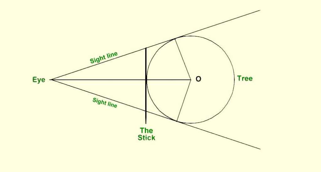
The most common way that Australian foresters measure tree diameter is to place a calibrated tape around the stem at breast height (1.3m). It’s simple, but can be slow, particularly if the scrub is thick, or if there are heaps of trees.
The Biltmore Stick was developed at the famous Biltmore forestry school in North America during the 1890s. It’s also sometimes known as a “Cruising Stick”.
The stick looks a bit like an everyday wooden yardstick with etched markings. They often include a Hypsometer scale to estimate tree height as well.
The specially marked Biltmore stick is held horizontally at arm’s length against the tree trunk at breast height. A sighting is then taken along the tangent of the stem to read the diameter directly from the scale.
By using some marvellous mathematics, and the trigonometry of ‘similar triangles”, the Biltmore measuring stick can quickly give a pretty accurate estimate of Diameter Breast Height Over Bark (DBHOB).
For some reason, the Biltmore stick is not commonly used in Australia, but some years ago I was involved in a trial to compare them to the more common diameter tape, and they were found after a bit of practice to be remarkably reliable.
Photo: Using a Biltmore Stick, Jasper County, South Carolina. August 1946: Source: Forest History Society
Some marvellous mathematics, and the trigonometry of ‘similar triangles”, the stick can give a pretty accurate estimate of diameter.
Metal branding hammers were the most common way to control the sale and movement of hardwood timber produce like logs, railway sleepers, fence posts, and poles from Victorian State forests. Royalty was also paid on this basis.
The hammer had a crown stamp on one end with a unique number in the middle which identified its owner, and a crows foot or broad arrow on the other.
The broad arrow was a symbol traditionally used in Britain and its colonies to mark government property.
Forest regulations state that an authorised officer may use the crown mark to identify produce which has been sold and may be removed from the forest, whereas the broad arrow can be used to brand and mark trees which are not to be felled, or to indicate forest produce which has been seized.
Hammers were traditionally only ever issued to forest officers and were an important, and closely guarded tool-of-trade. They were not transferred between staff and lending hammers was not permitted.
But it was an onerous task for staff to hammer and tally hundreds of logs, or thousands of fence posts each week, so in about 1990 a system was introduced whereby hammers were allocated to logging contractors to grade logs and tally them instead. But there was still spot checking by authorised officers.
A register was kept, and contractors paid a substantial deposit to make sure they didn’t lose them, but they occasionally turn up by fossickers with metal detectors.
While branding hammers are still used in some smaller locations, plastic tags and barcodes are now more common.
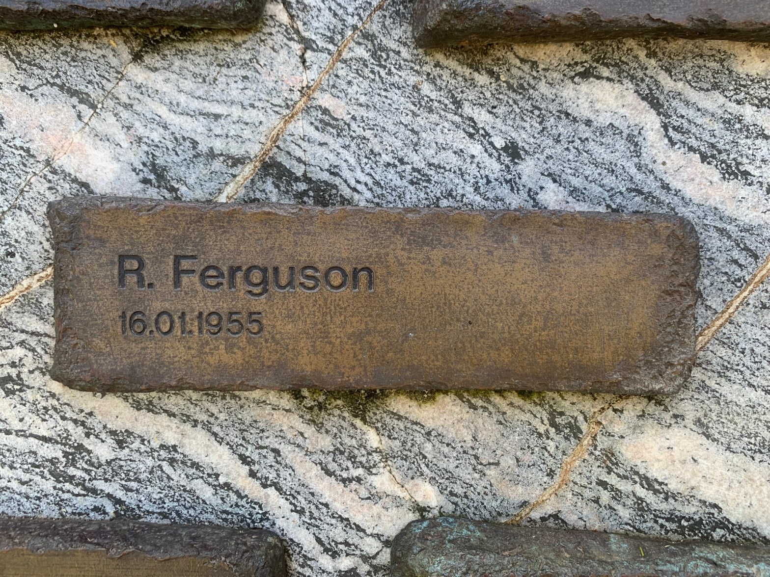
Reuben Douglas Ferguson died alone after he was crushed by a burning tree at a bushfire near Gembrook in January 1955.
Reuben was born at Greytown near Heathcote in 1897 and enlisted in 1916 with the 39th Battalion to serve in France, where he was gassed.
Reuben worked as a labourer and had been employed by the Forests Commission since March 1954. And like many others, he was stationed during the working week at the Kurth Kiln forestry camp, which is just north of Gembrook township.
Reuben and his wife, Veronica Mary, normally lived in Montague Street in South Melbourne with their children James, Elaine, Joseph, Daniel and Loretto.
On Saturday 15 January 1955 a small fire broke out in the headwaters of the Bunyip River and two gangs (i.e., crews) of about 20 men were deployed – one from Kallista and one from Gembrook which included Rueben.
The fire was only 20 acres in size, so at 11 pm the word was passed around for the men to leave the fireground and resume work at daylight on Sunday morning around 5 am.
However, the men left the line in three different vehicles, and at different times and, more importantly, there was no head count to make sure that everyone was accounted for.
To complicate matters, the men also split up, with some going to their homes in Kallista and Gembrook, while others went back to camp at Kurth Kiln. It was late and people were tired, and no one noticed that Reuben was missing at the time.
Tragically, Reuben was found dead by a search party early on Sunday morning. It’s believed he had died instantly when a large burning tree fell tree across him on Saturday evening.
He is buried at Melbourne General Cemetery.
At the inquest, the Coroner expressed concern that Reuben’s absence had not been noticed and that crews had left the line without him. The Forests Commission developed new safety procedures following the accident.
I don’t have the stats, but I bet most injuries and fatalities amongst forest fire fighters has been from falling trees.
Photo: Emergency Services Memorial – Treasury Gardens.
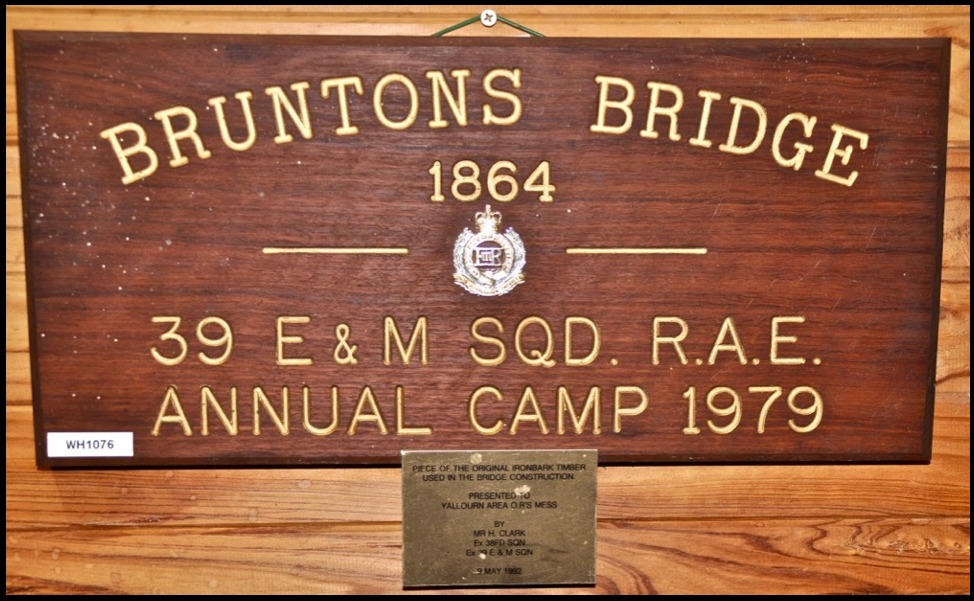
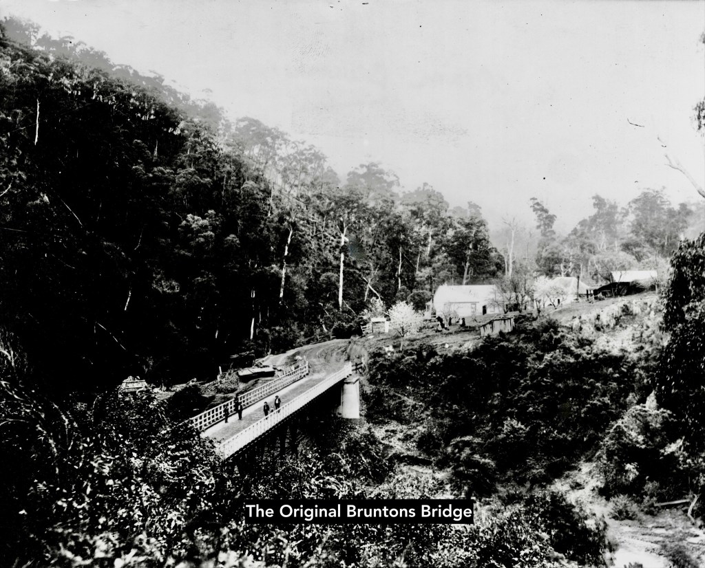
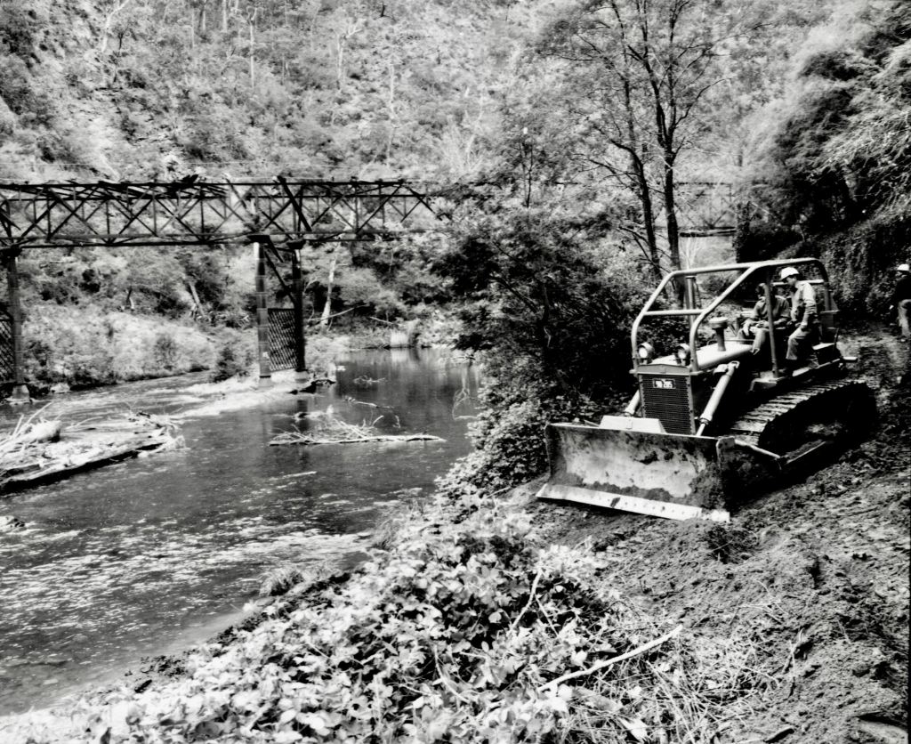
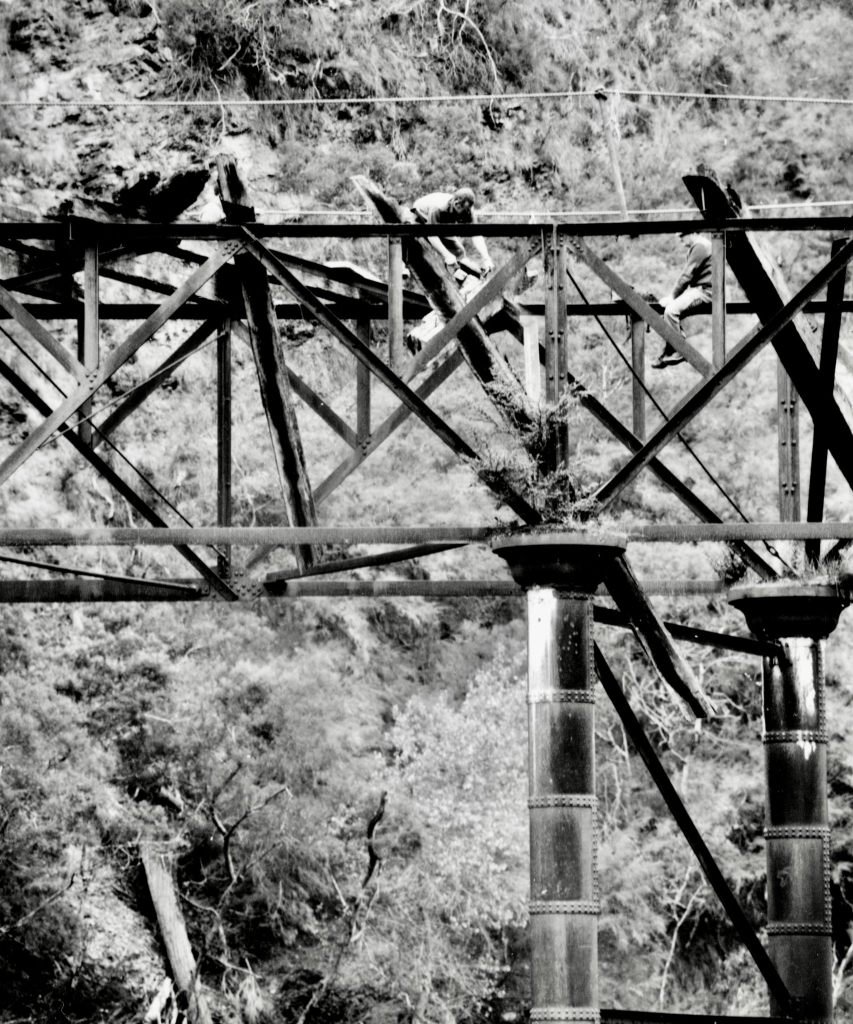
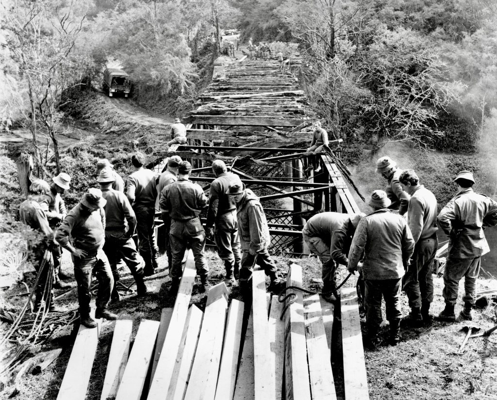
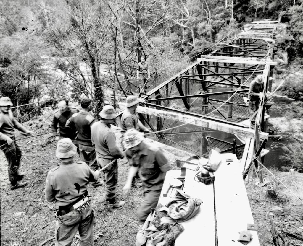
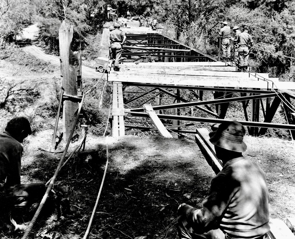
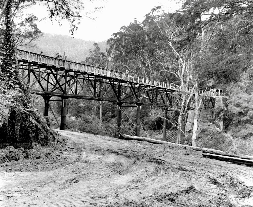
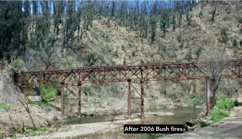
The iron framed Brunton’s Bridge is undoubtedly one of Gippsland’s engineering icons. It was opened in 1888 on the road from Toongabbie to the Walhalla goldfields.
Mr Mephan Ferguson, (Great-Grandfather of VSF forester, and later CFA Chief Fire Officer, Euan Ferguson) built the bridge under contract from the Public Works Department at a cost of £4690.
It’s said to be a replica of the Victoria Bridge over the Yarra near Melbourne and has a total deck length of 217 feet 7 ½ inches. It’s 18 feet wide and nearly 50 feet above the Thomson riverbed.
Six iron columns support the steel substructure with four steel spans which are thought to have been manufactured in England.
Red gum planks 5 inches thick were laid diagonally across red ironbark bearers on the top of the main girders which were secured by wrought iron bolts.
But the timber decking was destroyed during the 1939 bushfires and the bridge remained abandoned.
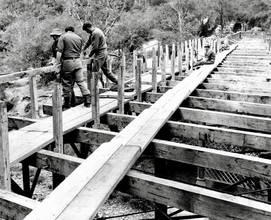
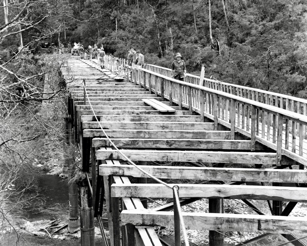
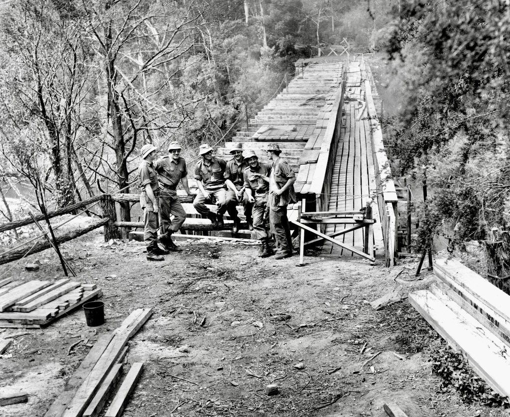
Restoration was planned after the successful re-decking of Poverty Point Bridge further up-stream by the Forests Commission, earlier in 1976
Many groups worked together on the restoration including Army Reserve’s 91 Forestry Squadron (The Woodpeckers), 39 Electrical and Mechanical Squadron based in the LaTrobe Valley, the Forests Commission at Erica, the Shire of Narracan, APM Forests, the National Trust, Latrobe Valley Historical Society, and engineering students from the Gippsland Institute of Advanced Education at Churchill, who tested the bridge structure before work began.
Between 17 October and 12 November 1979, the Woodpeckers prayed hard for good weather to cut the timber from nearby State forest for the bridge deck. Major Oliver Raymond, who normally worked as a forester for APM at Maryvale, led the project. Construction work at the bridge site was done by 39 E&M Squadron.
Later in 1982, the bridge was listed in the Victorian Heritage Register (VHR H1450).
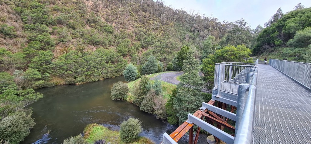
The timber parts of the bridge, including beams, decking and handrails, were once again destroyed by bushfires in 2006 and have been replaced with steel decking and handrails.
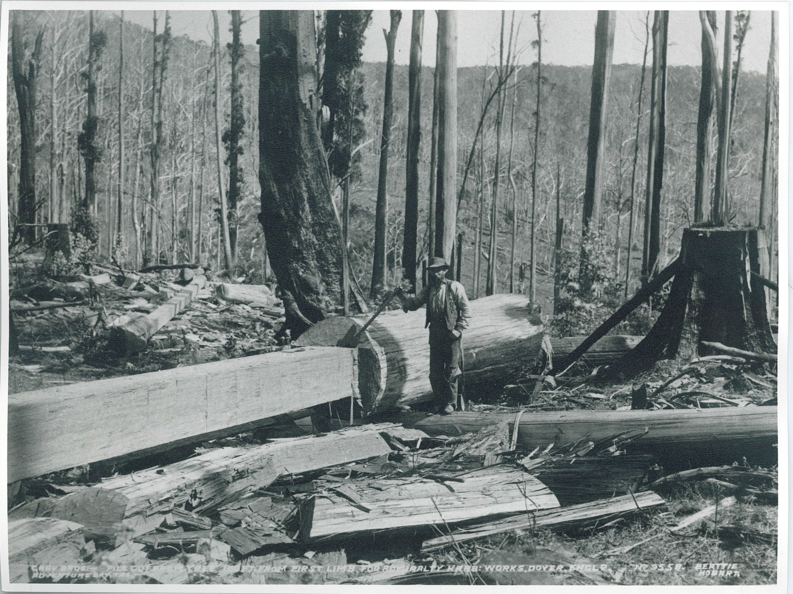
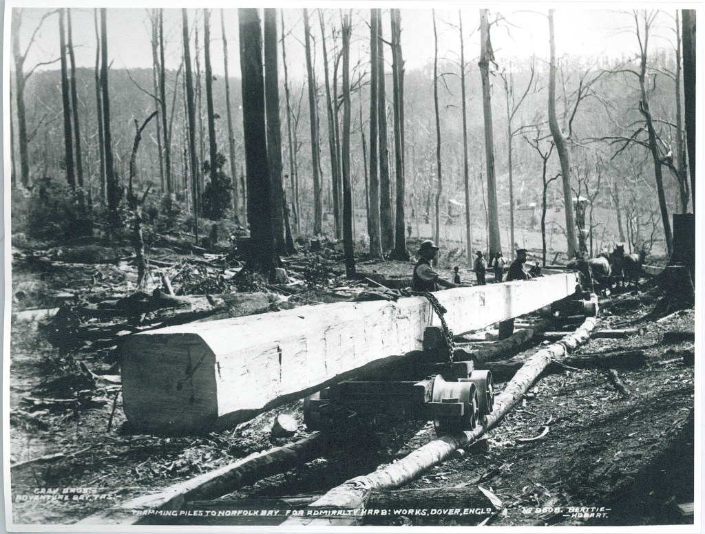
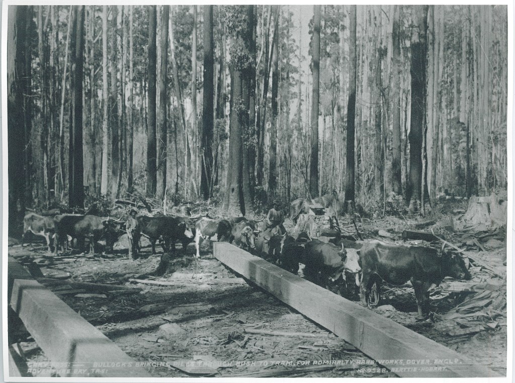
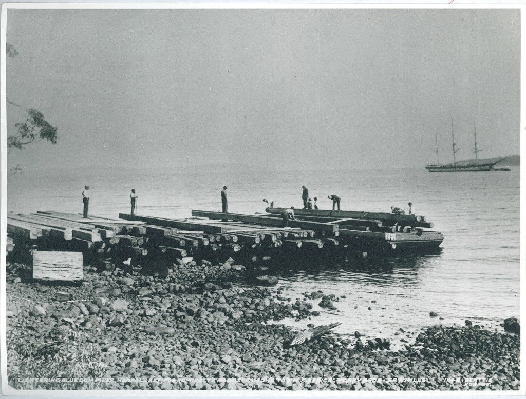
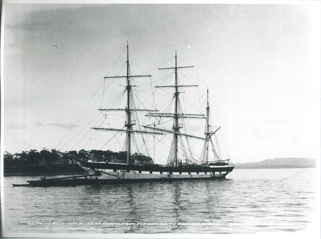
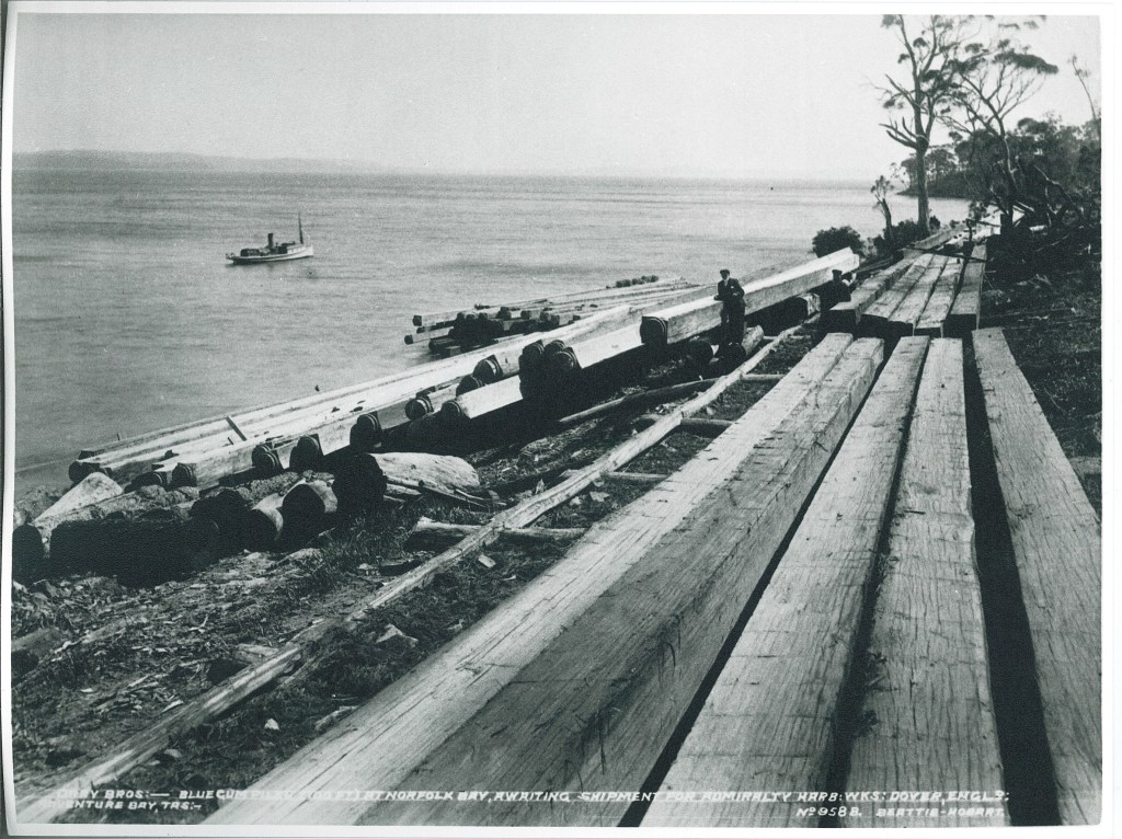
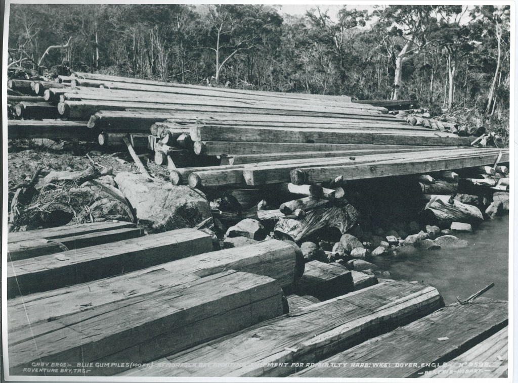
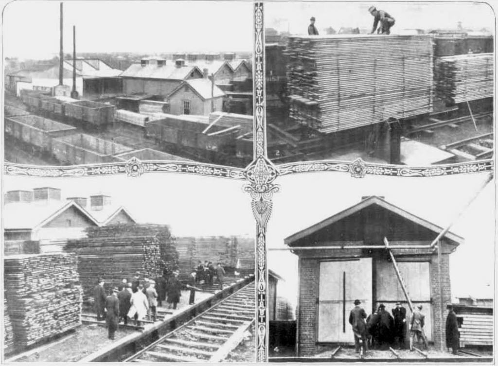
These photographs, taken in the early 1900s, are of 100 foot long Blue Gum (Eucalyptus globulus) piles produced by the Gray Brothers mills on Bruny Island in southern Tasmania.
The timber was destined as hewn piles for Admiralty Harbour Works at Dover in England and for similar works at Simon’s Town in South Africa.
The piles were floated out on barges and loaded lengthwise through a special port hole in the bow of the ship.
The company also operated a steam powered sawmill on the island which was fed by a network of timber tramlines.
Kevin Tolhurst graduated from the Victorian School of Forestry in 1976 and forged a stella career in fire research.
Sadly, Tolly died suddenly on 5 October 2023 at Mallacoota after a community bushfire meeting.
In the early 1980s Kevin led the ground breaking Fire Effects Study Area (FESA) project in the Wombat State Forest. The trial which ran for nearly 30 years was subdivided into five treatments with – a control, short-rotation spring, short rotation autumn, long-rotation spring, long-rotation autumn burning. The aim of the study was to determine the impacts of repeated low-intensity prescribed fire on fauna, flora, soils, fuels, tree growth and defect development in foothill forests. It remains one of the few long-term studies of its kind.
Kevin completed a Doctor of Philosophy in 1996 and during his career authored more than 200 scientific papers. He held the title of Associate Professor in Fire Ecology and Management in the Department of Forest and Ecosystem Science at the University of Melbourne.
His research led to the development of the PHOENIX RapidFire bushfire spread model, the Wiltronics fuel moisture meter and the Overall Fuel Hazard Assessment tool.
Each fire season, Kevin made himself available at Incident Management Teams, and State Co-ordination Centres during fire emergencies, including Black Saturday in 2009.
Chief Fire Officers from FFMVic and the CFA routinely sought Kevin’s advice and he undoubtedly had a major influence on Victoria’s fire management policies.
He was often called as an expert witness and spent hundreds of hours appearing at court cases and inquests including the Linton Coronial Inquiry (1998), Canberra Coronial Inquiry (2003), the House of Representatives Inquiry (2003), the Parliamentary Inquiry into the 2007 fires in Victoria and the 2009 Victorian Bushfires Royal Commission.
Kevin was made a Member of the Order of Australia in 2015. And in 2016, was honoured with the International Association of Wildland Fire’s ‘Ember Award’ for excellence in wildland fire science.
Tolly sadly died only a few weeks before receiving the N. W. Jolly Medal, which is Forestry Australia’s highest and most prestigious honour.
In his retirement Kevin and his wife Rosemary travelled Australia in their campervan and remained active in their local Creswick community and church.
But Kevin was an unusual academic. Not only a practical forester and brilliant bushfire scientist, Tolly also had a gentle and uncommon knack of communicating complex concepts in ways people could easily understand.
Equally at home in a lecture room or in the bush, Kevin is seen here in his element, wearing his green overalls and generously sharing his deep knowledge at a planned burning “masterclass” in the Albert Street bush near Creswick in November 2014.
Forests, fuel, weather, topography, heat, dust, dirt and smoke… all in real-time… aided by a box of matches…. together with his insightful commentary give just a glimpse of Kev’s unique gift.
There is an ancient proverb often attributed to Confucius.
I hear and I forget… I see and I remember… I do and I understand…
Kevin dispensing knowledge and wisdom at Planned Burn Task Force burn # 47 Willaura 15 Feb 2023. Photo: Christopher Simmins
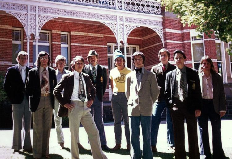
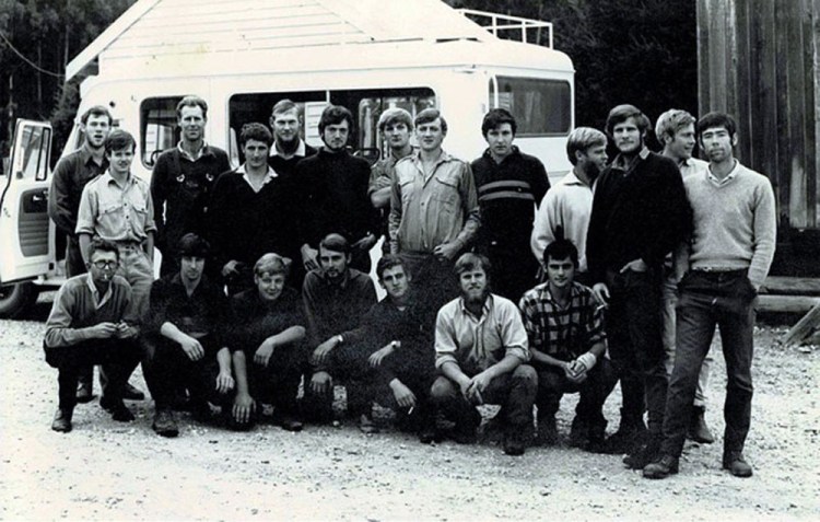
Graduating Class taken at the VSF in December 1976: L to R – Kevin Tolhurst, Andrew Buckley, Ron Harper, Brian Walsh, Gary Wood, Peter Novotny, Greg Esnouf, Mike Niven, Karl Rumba, Rob Willersdorf. FCRPA Collection.
Early foresters, as well as some sawmillers and timber merchants, recognised the unique qualities of Victorian hardwood timbers and the Government was keen to promote them to the world market.
But by far, the greatest proportion of dressed timber for internal work, joinery and furniture was expensive imports from North America and Scandinavia. There was also a strong reluctance from most builders, architects and cabinet makers to use local timber.
Native eucalypts had a reputation and being difficult to dry successfully, although there had been some initial success by Robert Affleck Robertson at the Wandong Seasoning Works between 1890 and 1903.
The prized native timber of the day was messmate (E. obliqua) and, generally speaking, mountain ash (E. regnans) was much despised by sawmillers. Many said the timber was unstable and too soft while others said it tended to rot. Few had good words to say of the timber that was often simply split into palings for the fences of Melbourne’s burgeoning suburbs.
Mountain ash was also very prone to excessive shrinkage and collapse of its fibres during the seasoning process. The traditional European method of kiln drying caused boards to severely deform and the corrugations could only be corrected by planing which was expensive and wasteful.
However, major research into native timbers began sometime after Federation in 1901 and progressed with the publication in 1919 of Richard Thomas Bakers seminal work “Hardwoods of Australia and their Economics”.
The Chairman of the State Forest Department, Hugh Robert Mackay, was determined to see the commercial application of Victoria’s vast mountain ash resource and in 1910 persuaded the State Government to establish an experimental seasoning plant on some disused railway land at Newport.
The revolutionary seasoning method was perfected by Mr Harry D Tiemann, a kiln drying expert from America, that Hugh Mackay invited over in September 1921.
Progress was frustratingly slow, but the breakthrough came with the simple discovery that steam reconditioning immediately after kiln drying expanded the timber back into a stable shape and the irregularities on the surface largely disappeared.
This simple technique resulted in mountain ash becoming the “Cinderella Timber” as sawmilling and seasoning plants in the forests east of Melbourne boomed.
The State Seasoning Works at Newport demonstrated the potential uses of Victorian hardwoods and this pioneering work done in partnership with the CSIR bore fruit. By 1931 it was estimated that 80% of flooring laid down in Melbourne was kiln-dried mountain ash milled from the State’s forests.
Some of the finished timber from Newport was even shipped to London to feature as flooring in Australia’s High Commission building.
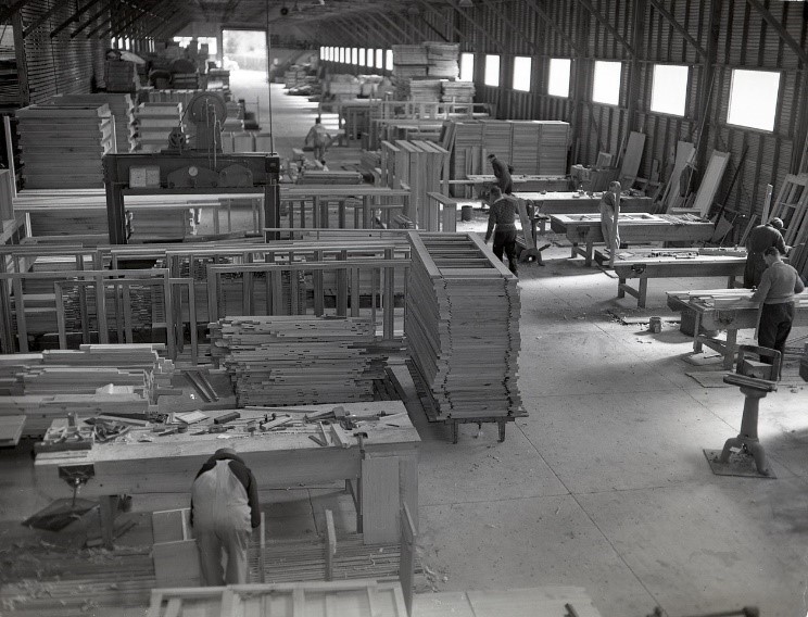
Most of the seasoned timber produced at Newport was used by government agencies such as the Public Works Department, technical schools and so on.
Also, the ubiquitous Stanley Huts were prefabricated in huge numbers at Newport. The huts came as “flat-packs” and could be easily transported, assembled and disassembled with very few tools.
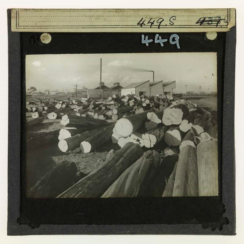
Most of the timber for Newport was supplied by the State sawmills, first near Nayook and later at Erica.
Newport closed under a controversial financial cloud in 1956. A situation made worse because the works had barely ever been profitable. Newspapers accused the Forests Commission of “juggling the books” to turn a loss into a profit. The Chairman of the Forests Commission, Finton George Gerraty died suddenly in June 1956, right in the middle of the crisis. The State Government was furious about the whole financial fiasco and there was talk of an independent inquiry and appointing an outsider to run the Forests Commission. It took more than six months for the dust to settle and for Alf Lawrence to be appointed as Chairman. He stayed until 1969.
Besides, after 46 years of innovative research and development, Newport had probably served its purpose. The Forests Commission had only ever sought to improve the position of native hardwoods in the market and put the Victorian timber industry on a sound footing.
But, with a few notable exceptions, most of the Victorian sawmilling industry was slow to adopt the expensive kiln drying process, preferring instead to sell green OB timber (Off the Bench) straight into Melbourne’s booming housing market.
Things shifted in 1986 when a long-standing principle of the Forests Commission was formalised in the Timber Industry Strategy (TIS). The better grades and species of sawlogs were then allocated under 15-year license agreements to those sawmills which could cut “value added” products like kiln-dried flooring and panelling.
Australian Sustainable Hardwoods (ASH) at Heyfield grew to become Australia’s largest hardwood sawmiller, kiln drier and quality timber manufacturer, but its future is under a cloud after recent State Government announcements about the cessation of hardwood native timber harvesting from 1 January 2024.
Ministerial visit to the timber-seasoning works at Newport, Wednesday, August 23, 1916. The green timber is stacked on trucks above a bed of charcoal in the drying kilns. Steam is then introduced, the temperature graduated, and in 16 days the boards are thoroughly seasoned. https://trove.nla.gov.au/newspaper/article/140697668
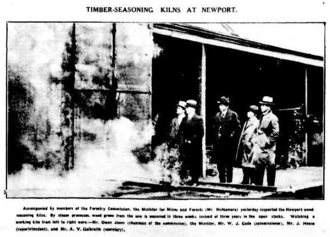
Accompanied by members of the Forestry Commission, the Minister for Mines and Forests (Mr. McNamara) yesterday Inspected the Newport wood-seasoning kilns. By steam processes, wood green from the saw is seasoned in three weeks, Instead of three years in the open stacks. Watching a working kiln from left to right were:-Mr. Owen Jones (chairman of the commission), the Minister, Mr. W. J. Code (commissioner), Mr. J. Hausa (superintendent), and Mr. A.V. Galbraith (secretary). Argus, 7 August 1924. https://trove.nla.gov.au/newspaper/article/4202468
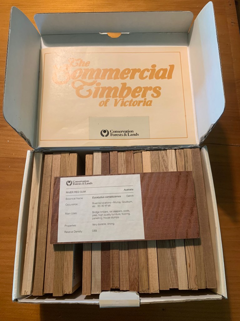
Samples produced by the department to promote Victorian hardwood timbers. Source: Simon Murphy.
The beautiful curves of wooden boats have surfaces which come together at odd angles and often use special timber shapes called “boat knees” to join them together and add strength.
Most woodworkers know that timber is strongest along the grain but will split when force is applied across the grain.
Timber can be bent, joined or laminated but boat knees from the natural crooks or bends in trees are highly prized by shipwrights. Tree roots are a common source of 90-degree bends.
In 1943-44 the Forests Commission supplied some 722 boat knees from State forest…
If an organisation is fortunate, it can claim a few colourful characters amongst its ranks. And over its long and proud history, the Forests Commission Victoria (FCV) had its fair share.
Alexander (Lex) Wade was one such character who grew up in the Dandenong Ranges east of Melbourne, and despite his many wanderings always seemed to gravitate back to his beloved hills.
Voluntarily departing Upwey High School in Year 9, Lex took a short-lived apprenticeship with the railways and a few farm labouring jobs.
In 1966 he was recruited onto the Forests Commission works crew at Kallista after a short chat with the well-regarded District Forester, Jim Westcott. Lex had found his “happy place”.
Lex started at the bottom of the pile with a hand slasher cutting fire breaks and as “billy boy” in Sherbrooke Forest. Around the same time, he joined the Kallista & The Patch CFA Brigade, in what became a lifetime affiliation.
Protection from bushfire of the communities and forests of the Dandenong Ranges became an overriding theme for Lex throughout his entire career.
The idea of Mobile Support Crews (MSC) had their origins after the Forests Commission’s Chief Fire Officer, Ted Gill, returned from a study trip to America in the mid-1960s.
Like their American counterparts, better known as Hotshots, Mobile Support Crews were based on the temporary employment of fit young people as mobile, highly trained, well equipped and well-led firefighters to give additional surge capacity when needed.
MSCs were based at Benalla, Bruthen, Broadford, Heyfield (Connors Plain and later Surveyors Creek) as well as Stawell over summer.
The size of each MSC ranged between fifteen to eighteen people and was self-contained with vehicles, radios, camping and firefighting equipment, including chainsaws, rakehoes and axes. Depending on where it was based the MSC may have included a camp cook.
In 1968, Lex left Kallista District to join the Heyfield MSC based at Connors Plain, northwest of Licola. The crew was supervised by John Wilson, the engineer in charge of local road construction works.
The end of the fire season in 1969 saw Lex head off to Benalla to plant pines over winter in the chilly Strathbogie Ranges. He applied for but missed out on the sought-after FCV foreman’s school, so took some other work such as driving trucks for the next few years.
15 October 1980 remains an important date for Lex because it was when he secured a permanent role back with the Forests Commission at the Sky-High restaurant near Mount Dandenong.
In 1982, Reub Watson retired from Gembrook and Lex happily moved onto the works crew. His mentors Bob Ferres, Bill Rankin and Butch Reid all helping to cement his practical down-to-earth outlook and hone his many bush skills.
The 1982-83 bushfire season is best remembered for those on Ash Wednesday on 16 February 1983, where 47 people died In Victoria and a further 28 in South Australia. But other significant bushfires occurred right across Victoria from August 1982 until April 1983, and it proved a long and hectic fire season for all Forests Commission staff.
Lex drove the Gembrook Bedford M Series tanker (MZF 347), first to South Belgrave then to Upper Beaconsfield and later to Cockatoo on the fateful and manic Ash Wednesday.
While generally considered “bulletproof” the petrol fuel lines on the Bedford were very prone to vaporise in the heat causing the motor to stall, often at the most dangerous moment… in this case frightening the crap out of its driver.
Some jokingly said this design quirk was an inbuilt safety feature to stop crews getting too close to the fire in the first place.
The old Bedford warhorse was subsequently rescued from the scrapheap after its retirement by Lex and fire equipment wizard Rocky Marsden. After a lick of fresh paint and most of its battle scars “buffed out”, this time-honoured veteran now takes pride of place at the Department’s Altona North workshop.
In 1984, Lex moved to Benalla to lead the local Mobile Support Crew, before returning a year later in 1985, like a moth-to-a-flame, to the familiarity of the Dandenong Ranges.
His move back home was around the time of the major restructure and the formation of the Department of Conservation, Forests and Lands (CFL).
Following the Ash Wednesday fires and the formation of CFL there were some significant changes to fire training including a new fireline supervisors’ course in 1985, where Lex took an active role in shaping and delivering the innovative program together with John Nankervis.
Lex made a move from Gembrook to Ferntree Gully in about 1989 and took a role as a Ranger in the newly created Dandenong Ranges National Park.
On the 14 January 1985 there were 111 lightning strikes in 24 hours across Victoria’s alpine region that caused widespread fires, with the largest at Mt Buffalo. Aircraft from the Army, Navy and AirForce were once again deployed, plus a major fleet from the National Safety Council of Australia (NSCA). It proved the largest operation of firefighting aircraft in Australia up to that point.
These fires not only tested both the new Department and the AIIMS system but highlighted some serious shortcomings in aviation management. As a result, Richard Alder, Bryan Rees and others quickly established new aviation roles, training and accreditation to control aircraft at bushfires.
Lex underwent air observer training in 1998, which was followed a year later gaining accreditation as an Air Attack Supervisors (AAS). Lex proved a natural in the air and took many senior leadership roles in bushfire aviation over the subsequent decades.
While not universally welcomed or adopted by other fire agencies, the common structure and language of AIIMS enabled firefighters to be deployed overseas to America and Canada in what has now become a routine exchange.
Lex and his inseparable friend Ion Worrell (Wol) were like peas in a pod… if you found one… the other wasn’t far away. Unsurprisingly, Lex and Wol were both amongst the first contingent of firefighters to leave Australia in 2000, serving in Idaho and Montana.
In the off season, Lex retained his “day job” at Olinda focusing on fire training, dangerous tree assessment as well as liaison with other emergency services. There probably isn’t a Policeman or CFA Captain in the Dandenongs that hasn’t enjoyed a cup of tea and a bit of banter with Lex as he nurtured these important relationships.
Lex was very deservedly awarded the prestigious Australian Fire Service Medal (AFSM) in 2002. This honour was in addition to his National Medal (1993) and National Emergency Medal (2013) for the bushfires on Black Saturday.
The CFA also recognised Lex with long service medals and life membership.
Widely known across the Dandenong Ranges, and even far beyond, Lex retired from Parks Victoria in 2020 after a lifetime of service.
However, retirement gave Lex more time for his second love of motor sport. As a one-eyed “Holden Man” Lex volunteered with gusto as a rescue firefighter at many premier race events including 25 of Melbourne’s Formula One Grands Prix.
Lex has confronted a couple of major health scares recently including spending nearly three months in Box Hill and Monash Hospitals. He remains astonished and humbled by the depth of support he received from a wide network of generous friends.
As well as being an affable knockabout bloke and firefighting legend, Lex was sometimes likened to a jovial and lovable garden gnome. But everyone who met or worked with Lex has their own engaging anecdote to tell.
It’s simply not possible to sum-up Lex in a mere sentence or two. There are so many worthy qualities including a life committed to protecting forests and communities from bushfire, a dedication to safety, a selfless focus on others, a forthright willingness to speak plainly, lasting friendships, and fierce loyalty. All this topped with a generous layer of infectious humour and effervescent larrikinism.
Lex Wade remains truly one of a kind…
Mobile Support Crew at Connors Plains – 1968/69. Standing (L to R) – Dave Buckle, Kester Baines, John Wilson, Alan Falkingham, Dick Noble, Peter Fitzpatrick, Euan ‘Wanga’ Thompson, Tim Clark, Kevin ‘Wings’ Holland, Brendan Lay, Dave Hannah, Tim Hannah, Ian Walkley. Squatting (L to R) – Peter Thomas (Cook), Ray Trenfield, Lex Wade, Craig Irvin, Neville Horan, Ross Foster, Robin Young. Source: FCRPA CollectionLex at Altona. October 2023.Like peas in a pod. Wol and Lex.At Olinda base.At Sandown Racecourse
Australian Fire Service Medal (AFSM), National Emergency Medal for Black Saturday in 2009 and the National Medal (with clasp)
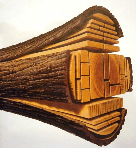
The losses from converting round logs onto square sawn timber depends on the species of tree, the diameter and length of the log, straightness and the overall taper of the log, internal defects and waste.
Sawn timber recovery can vary from 40 to 50% of the gross volume (cubic metres) for a large mountain ash sawlog. Smaller or defective logs have much lower recovery.
The recovery rate was one of the main factors used to determine log royalty (price) and was sometimes hotly contested by sawmillers.
Waste includes the outer round edges, docking of internal defects like knots and rot as well as sawdust.
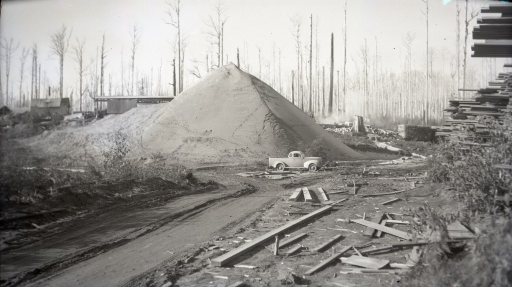
Sawdust can account for 15-20% of the overall log volume loss.
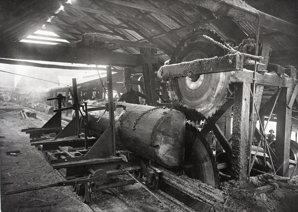
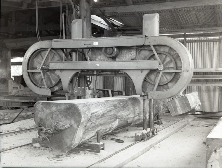
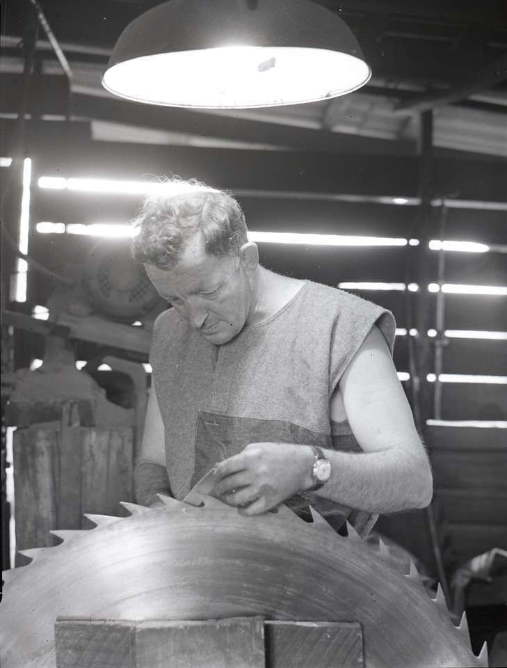
The type of saw is also important. Older circular saws were much thicker than modern band saws. This width is known as the “kerf” and typically was as much as 3/8 inch (9.5 mm) for a large breaking down saw and 1/8 inch (3.2 mm) on resaw benches.
The kerf depends on the thickness of the steel blade and the “set”, or offset of the teeth, the amount of wobble in the blade during cutting, and the amount of material pulled out of the sides of the cut. Keeping saws sharp and in shape required the skills of a saw doctor.
Modern bandsaws have thinner blades and narrower kerf teeth which operate under high tension. They produce more accurate cutting with less sawdust loss.
The quantity of sawdust produced depends not only on the kerf of the blade, but also sawing pattern and the number of cuts. Smaller dimension timber like garden stakes or fence palings need many more cuts than large structural beams or floorboards.
There may be further shrinkage losses as the sawn timber dries and needs to be dressed and planed into shape.
Older sawmills literally produced mountains of sawdust waste if there wasn’t a teepee burner or firepit nearby. In a few cases sawdust was recovered and used to make bricks.
Sawdust can also be made into wood flour and used for soil additives, filters, extenders for glues, fillers in wood composites as well as absorbents for explosives.
But sawdust has high levels of tannin and, in the absence of bushfires, can take decades to break down. There are still plenty of old heaps dotted around the bush.
Twin circular breaking down saws had a wide kerf and were prone to wobble which generated more sawdust.
Bandsaws have thinner blades which operate under tension. They produce more accurate cutting with less sawdust loss.
Written by his family and contributed by his son Tony Edgar.
William James Edgar was born in Yenda in the NSW Riverina on 11/11/1927. At the time of his death, he was a father of seven, a grandfather of 22 and a great grandfather of 22.
He has always been known as Bill. His parents were Keith and Magdalen Edgar. His mother was known as Queenie. He had an older sister, Irene. Keith was a returned serviceman and had taken up a soldier settlement block at Yenda growing grapes. When phylloxera hit the Yenda District in the late 1920’s, like many others, they left their block and moved to Sydney. Bill has very little memory of their time in Sydney. They shortly afterwards moved to May Grove in South Yarra to live with Queenie’s family. After a short time they moved to 9 Arthur Avenue, Brighton where Bill lived until he left home at 16.
When Bill was about three or four, he and his mate Jack decided to go down to Hampton St to visit the cannon. They made it to the cannon and climbed on it but couldn’t find their way home. Someone took them home and Queenie was very upset. She took Bill to the local school and asked if they could look after him. Bill said that the school agreed and a really lovely nun looked after him and he loved it. Bill talked about all of the local kids playing out front in the street. One of these kids got polio and couldn’t play anymore.
Bill attended the local catholic school. He had an active sporting life and particularly enjoyed swimming. Summers involved spending a lot of time at the Brighton Baths. Bill had an aim to ride from his home to the baths on his pushbike without touching the handlebars. As this involved crossing a couple of busy roads he rarely achieved this.
In his teens he swam in competitions and at one stage held an under age Victorian breaststroke record. He was also a very good diver and gymnast. Bill was involved in scouting and became a King Scout. The mayor of Brighton who lived in their street told him that he was the only King Scout in Brighton.
Keith, his father, obtained work as a proof reader for The Age newspaper. This was primarily to proof read the advertisements which were in the paper. Initially he would line up outside The Age offices in the evening and hope that he would be selected to work that night. If work was not available he would catch the train home. If he obtained work he would get home as Bill and Irene were heading off to school for the day. After a while Keith got a permanent position, so his children saw little of him as their sleep cycles were so different.
Bill’s mother Queenie was an excellent seamstress and the main breadwinner in the family. Bill talked of hearing her sewing late into the night every night. She had a lady who came in on Saturdays to help with housework. She did work on commission for a couple of shops in Melbourne. Bill recalled taking finished articles to the local train station where they would go by rail to the shops in Central Melbourne. She made coats for General Douglas MacArthur’s children during World War 2.
Bill as a young lad got a Saturday morning job at a local shop to do deliveries. He rode his pushbike and had to be able to give change. Bill was proud of his work and the trust placed in him to handle the money.
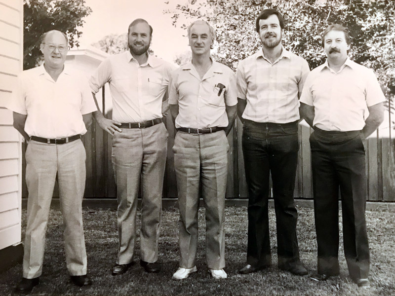
Bill applied to enter the Victorian School of Forestry (VSF) for the 1943 year. He was unsuccessful and went to school for one more year. He spent this year at St Kevins after having spent his previous years at Christian Brothers College. He had obtained his leaving certificate from the University of Melbourne by passing English, Mathematics III and Physics in December 1942 and French and Chemistry in February 1943.
At the end of 1943 he passed his Matriculation and again applied to VSF and was accepted for the 1944 intake. This was a three year Diploma Course resulting in the awarding of a Diploma of Forestry (Creswick). There were only 24 students when he started, with twelve in his year.
This number increased with twelve new students in 1945 and thirteen in 1946. By 1946 some of the students were returned servicemen who would have been older than the third year students.
Bill enjoyed his time at Creswick. It was a fairly regimented system, not unlike a boarding school. Students were expected to study at night. Accommodation and meals were provided. Students were required to attend church on Sundays. Most students, including Bill were bonded to the Forests Commission at the completion of their course. Saturday mornings were devoted to field work where students were tasked to various jobs in the Creswick Demonstration Forest.
During his time at VSF, the School entered a football team in the local Clunes League. They had a number of fairly handy footballers, including Jeff Brisbane who had played for Geelong in the VFL. Bill was also among their better players. Years later when Jeff Brisbane umpired a VSF match he told Tony that Bill was a very good footballer.
Bill graduated in 1946 and was posted to Assessment Branch. One of his first assessments was at Connors Plains north of Licola in central Gippsland. Bill tells the story of this assignment in an interview he did which can be found at………
His next postings were to Forest Protection, Delatite, Scarsdale and then Corryong. While at Delatite Bill played in a band as a drummer. It appears that his main task was to supply the whisky. He also played football for Mansfield.
At Corryong Bill was the Assistant District Forester. He continued his football career. One night after being at the pub, Bill was driving home four abreast in a Land Rover. While going around a corner, the driver’s door flung open and Bill, who was driving, fell out. He broke his pelvis and was taken to the Corryong Hospital where Sheila Drill was a nurse.
Bill decided she was a bit of “all right” and began courting her. Sheila had taken a job at Corryong and had intended to then move to Sydney. Bill proposed a number of times before Sheila said yes to him. They were married at St Ignatius in Richmond on May 23, 1953. Bill’s father in law Leo was not too sure of the relationship as he thought all public servants were lazy buggers.
In November 1953, Bill was promoted to District Forester at Beechworth. As Bill and Sheila did not have a car, Dick Caddell, an overseer from Beechworth drove to Corryong and picked them and their possessions up in the forestry truck.
In Beechworth, both Bill and Sheila became heavily involved with the local football club where Bill was one of the star players. The local doctor was the club President and when Michael was born in 1954 did not tell Bill until after Bill had finished training. Tony and Kevin were born in 1955 and 1956. While at Beechworth, Bill commenced a thesis to obtain a Diploma of Forestry(Victoria). Without either a Bachelor Degree or this Diploma the Forests Commission would not promote anyone past the level of District Forester.
In September 1958 Bill was transferred to the Erica Forest District. At that time this was one of the biggest and most complex Districts in the state. As well as running the District, Bill was in charge of the State Sawmill located in Erica. This mill took a lot of time as it had never generated a profit. Bill had also not yet completed his thesis. He had done the field work but needed to submit it and have it assessed. The thesis was “A Working Plan for the Chiltern Forest”. Bill and Sheila bought their first car at about this time. They welcomed Mary and Brendan into the family in 1959 and 1960. Bill’s football career ended as Erica did not have a team and it would have been too difficult to play with any nearby town.
Bill found the work at Erica quite stressful. He came down with rheumatic fever and was hospitalized for a short time. As a consequence he was transferred to the Nyah District in 1962. The Nyah District extended along the Murray River from Hattah National Park to Swan Hill. Andy joined the family not long afterwards. In Bill’s words, he said he thought that he had died and gone to heaven when he arrived at Nyah, and then they sent me Webby. Webby is Brian Webb and Brian and his wife June moved to Nyah shortly after the Edgars. Bill and Brian were like peas in a pod, as they both enjoyed fishing, hunting and being outdoors. They had drum nets in the Murray River and both families had lots of feeds of fish and Murray Crays. There was also an abundance of fresh fruit and vegetables to be had. Bill played golf at the Nyah golf club and lots of summer weekends were spent at Picks Point swimming hole on the Murray. It was while at Nyah that the FJ Holden was moved on and Bill and Sheila bought a Ford Customline.
Holidays were taken during school holidays and were spent at Trentham with Bill’s parents or Hawthorn with Sheila’s. At Trentham, Bill and the family would cut a year’s supply of firewood for the Lux stove in the kitchen. Bill could cut wood quickly enough to keep all of the older children busy stacking.
Hawthorn trips often involved a walk to watch Hawthorn training. Bill switched his football allegiance from Richmond to Hawthorn. It was a terrific decision as Hawthorn have been the most successful club of the last 50 years by a considerable margin.
The next move was to Neerim South in 1965. This was another very busy District which included the Baw Baw Ski Resort which was run by the Forests Commission. While the main office was at Neerim South, the main depot was at Noojee. Bill and Sheila spent a fair bit of time making sure that the local pool was usable. The pool filled from the local creek and had to have the slime removed each year before filling. The water was not treated, so it had to be emptied and refilled.
By now the older children were involved in organised sport. A fair bit of time was needed to cart them around to their various events or to organise a lift for them. Bill was also very supportive of the children joining cubs and later scouts, and he often helped when he could. Bill had a brief, not very successful, cricket career while at Neerim South. Rob became the latest member of the family when he was the last child born in the old Neerim South Hospital. Bill was rung from the hospital to say he “had another little woodchopper”.
In 1968, Bill was promoted to Assistant Divisional Forester for the Western Division based in Horsham. For the first time since having children the family lived in a house without a wood stove in the kitchen. The house was on the outskirts of Horsham and unsurprisingly, life was fairly hectic. The children now ranged from being in Form 3 down to Rob who was still some way off starting school. Luckily, the older children were able to get themselves to many of their activities. Bill and Sheila also did a lot of running around to various events, as they encouraged all of their children to participate in sports.
The ADF role involved quite a bit of travel as the Division extended from the coast up to Mildura. It also included the Grampians which at that stage was being managed by the FCV. There were lots of family trips to the Grampians for picnics and to look at various sights. Favourite outings were the walk through Wonderland to the nerve test and swimming in the hot pools at Zumsteins. Bill also took up lawn bowls in Horsham and won a few trophies.
Bill and the family liked to frequent Op Shops when holidaying in Melbourne. Bill found a very expensive Rolleiflex Camera on one of these visits and became quite a good photographer.
Bill had a large vegetable garden at Horsham that extended into the neighbours yard. Vegetable gardens were a constant at most places he and Sheila lived. Bill was always on the lookout for free food. All of the family were involved in collecting foods such as tabbies, blackberries, apricots, walnuts, almonds, asparagus, mushrooms, plums, figs, mulberries and apples. Bill and Sheila made blackberry jam, tomato sauce and tomato chutney most years and shared them with their family.
Bill was an excellent shot and often took the whole family rabbit shooting at dusk. He would shoot rabbits from the car window after they stood when captured by the headlights. At times he would try to get two rabbits with one shot. Rabbit casserole was often on the menu, particularly at Neerim South.
Bill was promoted to Divisional Forester for Southern Division in 1972. This involved packing the family up and moving to Traralgon. By this stage Michael had left home to attend Monash Uni and Tony was about to do the same. Up until this stage in their marriage Bill and Sheila had always lived in houses provided by the FCV. As a Divisional Forester, Bill would not get a house so they had to buy one. In their usual methodical manner, Bill and Sheila listed what they wanted in a house and Bill travelled to Traralgon and in a few days bought a house which best met their needs. This was quite a challenge for them as it meant going into debt. They borrowed some money off Sheila’s dad, Leo, so that they could buy the house at 4 Charles St.
Southern Division included the Neerim, Erica, Heyfield, Maffra and Yarram Districts. This was one of the busier Divisions. The APM paper mill was in the Latrobe Valley and many of the Districts had active plantation extension programs. The Yarram District included the Strzeleckis where the FCV were buying farms to plant pines or eucalypt plantations.
Fires were also fairly constant with multiple lightning strike fires being a common occurrence. Bill had a radio installed at 4 Charles St so that he could listen in to the chatter from the fire towers during summer.
As a Divisional Forester, Bill was part of the FCV Central Council which met in Melbourne regularly. This was an event which he did not enjoy and for which he was always well prepared. Bill often enjoyed travelling to some of his old haunts to see how things had changed. Over his career and into retirement seeing the reforestation and silvicultural treatment of the Strzelecki Ranges and other areas such as Boola Boola State Forest gave Bill enormous satisfaction. He got quite a kick out of seeing areas which had been treated silviculturally thriving.
Bill and Sheila had always had a very strong involvement in the Catholic Church. All of the family attended Mass on Sundays from when they were babies. In Traralgon this involvement became stronger. After retirement Bill and Sheila usually attended mass daily. They also involved themselves in many church committees and projects.
While Bill has since lived in Sale for a short while, the majority of his and Sheila’s life continued to be lived at 4 Charles St until not long before Sheila’s death.
Bill had a significant health scare in 1980. He had a heart attack which culminated in a triple bypass at the Alfred Hospital. This operation was quite risky at the time, with the chances of success being put at about 50%. The operation was successful and about three months later, Bill was back at work. Bill liked an occasional menthol cigarette, a beer in the evening and he loved a bit of Devon Ham, none of which are great for your heart. He improved his diet and started to exercise more. If he strayed with his diet, Sheila would make sure he got back on track.
Bill remained as Divisional Forester until the creation of the Department of Conservation, Forests and Lands in 1982. The new Department had 18 Regions and Bill applied to be the Regional Manager for the Traralgon Region. For the first time in his career he had to be interviewed for a job. He took a lot of time putting his application together and was quite nervous about the interview. He was offered the role as Regional Manager at Yarram, which was at a higher level than the Traralgon role. The Yarram Region included the Wilson’s Promontory National Park and also had an active plantation extension program on farmland which the Department purchased. Bill remained in this position until his retirement. Bill enjoyed running the Region but struggled a bit with some of the politics which were inevitable at this senior level.
During this time, Mary and Paul were building a rock house at Seaton. This was going slowly, so Bill took three months long service leave and he and Sheila drove out to Seaton each day and laid rocks. Bill has often said that he got a great deal of pleasure from doing this. The work he and Sheila did made a huge difference to the time it took to finish the house.
Bill remained Regional Manager until retirement at age 57. He took most of his superannuation as a pension, but also took a lump sum payout. From the lump sum he purchased Rocky and a boat. Rocky was a yellow Daihatsu four wheel drive and it gave him the freedom to take day trips through the bush or go fishing. Bill took great pride in being self sufficient financially in retirement. He had a small share portfolio and closely followed his investments. He kept meticulous financial records recorded in an exercise book and did all of his own tax returns.
Retirement gave Bill and Sheila the opportunity to travel. For several years they took trips around Australia. Bill never had any strong interest in overseas travel. They did travel to New Zealand and enjoyed this trip. They also particularly enjoyed traveling to northern Australia. One trip was to the Northern Territory and on returning Bill said that he was less than impressed with Kakadu and dubbed it Kaka don’t. Bill and Sheila also visited Andy and Monica in Singapore when they lived there. Bill was very taken with the wet markets.
Bill and Sheila were also happy to help their children. They would travel and stay with the children and loved the interactions with their grandchildren. These trips were to a fair few different towns as their children shifted around. This was also a good opportunity to have a look at cities such as Canberra and Singapore. Bill would always visit his sister, Irene, when in Canberra.
Bill and Sheila also looked after grandkids when Michael and Tony lived in Traralgon. They often did school and kinder pick ups and established really close relationships with the children. Everyone was treated equally by Bill and Sheila and they could always be relied on for help when needed, or they would provide support unannounced.
A constant through Bill and Sheila’s marriage were trips to Cowes. Sheila’s father Leo owned a house at 11 Walpole St Cowes and many holidays were taken there. The house needed a lot of looking after, but this just gave more opportunity to spend time there. While the children were younger, there were often gatherings of the Edgar’s and their cousins the Hampshire’s. When Leo died in 1987 he left the house jointly to Sheila and her sister Kath. Bill and Sheila usually spent at least a month a year at Cowes after retirement and encouraged their children and grandchildren to also spend time there. Card games were played with no prisoners taken, and if the game was 500, Bill’s team nearly always won.
Bill discovered how to collect abalone and found some reliable spots. It became a bit of a ritual to look for low tides and calm weather and take as many people as possible to collect the bag limit of ten per person.
Fishing was a passion of Bill’s. His ex colleagues often mentioned Bill giving them a big wave and a smile as he headed off fishing while they were working. Rocky with the boat on the back was a familiar sight in Gippsland. For a number of years he and Norm Cox and sometimes others would head to Tamboon Inlet for a few days fishing. Bill would save his favourite whisky for this week away and looked forward to it enormously.
For many years, Bill and Sheila volunteered at Vinnies in Traralgon. They were in charge of toys. Their house in Traralgon often had the carport full of toys which they brought home to clean, fix and price. They were both very proud of the amount of funding that their work brought in.
Bill and Sheila enjoyed doing cryptic crosswords. There were always a pile of crosswords waiting to be completed sitting on the table at Charles St. It might take days to complete some of the more difficult crosswords but Bill would persevere until they were finished.
Bill had a number of health concerns over the years. He had a chronically bad back which would occasionally “go” on him. Later in life he showed Rob the spot on a bridge on the Murray River near Corryong where he first injured his back as a young man, apparently diving into the River to impress Sheila. On one occasion Michael and Tony got a panicked call from Sheila to come and move Bill. He was standing in a doorway and was unable to move. He needed to be carried to bed. One way he dealt with this was by walking. He would walk a number of kilometers a day. He liked being outside and the walking helped his back.
Bill had a second triple bypass when he was 80 with the same surgeon who had performed the previous operation. The chances of survival had markedly improved despite his advancing years. The surgeon was very surprised to see that the first treatment had worked for so long.
A few years ago, Bill had bowel surgery. He was in intensive care for quite a while and had a long recovery. Bill realised that he and Sheila could no longer continue to live at 4 Charles St and put the house on the market. They decided on an agent and their price and were really happy when the house sold almost immediately. When he was released from hospital, Bill and Sheila lived with Michael and Cheryl in Morwell for six months until they found a small unit in Sale that really suited them.
Bill recorded a couple of short videos in 2021 where he expressed how grateful he was for the work that Mary and Michael did looking after him and the meals that Andy would drop off, Chicken Cacciatore being a particular favourite.
Sheila passed away in early 2020. Bill continued to live on his own at the unit with Mary making sure that he had everything he needed. Bill missed Sheila enormously. One way he dealt with this was by walking, which helped his back and general health. Bill was still driving until about a year before his death and most days would drive to Lake Gutheridge and walk around the lake.
More recently Bill moved to Margery Cole Aged Care in Traralgon. His health deteriorated and he passed away peacefully on the 25 September, 2023.
Image: Yarram CFL Regional Management Team (RMT). (L to R) Robert (Bob) Niggl – Operations, Ian Leversha – Resource Conservation, William (Bill) Edgar – Regional Manager, Ken King – Public Land Management, Ralph Hubbert – Services. Source: Bill Edgar c 1985
Photograph taken in 1978 – Reunion of Erica District Foresters : l to r – John Youl (1928-1934), Charles Elsey (1936-1942), Arch Shillinglaw (1934-1936), William (Bill) Edgar (1958-1962), Hugh Brown (1969-1971), Max Boucher (1966-1969), Ray Baker (1975-1983), Brian Williams (1958), Noel Birch (1971-1975), Alan Threader (1953-1958), Stan Duncan (1962-1966), Jim McKinty (1949-1951) – Not Present: Leslie Strahan (1924-1928), Henry Irvine (1942-1949), Jack Gillespie (1951-1953). Note : Don Thomson was DFO from 1983-1985
Australian foresters are lucky to no longer endure some of the older “head scratching” imperial measurements.
Hoppus Log Volume (HLV) was used around the British Empire and is still used in some countries.
Introduced in 1736 by English surveyor Edward Hoppus, it estimated the volume of a round log that would produce usable or merchantable timber after processing. This was in effect, attempting to “square” a “round” log.
Round logs were measured at the midpoint for circumference (or girth) in inches and length in feet.
Hoppus Log Volume, in cubic feet, was calculated using one quarter of the girth, which was then squared and multiplied by the length of the log, with the total then divided by 144. This method slightly underestimated the volume of the log but did away with the using the pesky π.
The combined result of “squaring” a round log, as well as allowing for the quarter girth technique, meant that Hoppus Log Volume was 27.3% less than the “true”, or round, log volume. This was intended to allow for sawn waste.
One cubic foot hoppus is a lump of wood 1 foot wide by 1 foot long and 1 foot thick.
The Forests Commission traditionally measured and reported the production of sawn timber in super feet – which was short for superficial feet. Sometimes also known as a board foot it represented a piece of sawn timber 1 foot wide by 1 foot long and 1 inch thick. There are 12 inches in a foot, so one cubic foot equalled 12 super feet.
Round logs were measured and reported by the Forests Commission in Super Feet Hoppus Log Volume.
Confused… so were most people… but from 1 July 1974 all logs and sawn produce were thankfully measured in cubic metres (true volume).
However, in the United States and Canada, buying and selling logs as well as standing trees is still based on board feet.
There are also over 95 log scaling rules bearing about 185 names. However, only three, Doyle’s, Scribner, and International, are widely recognised and in current use, but they can vary across the country.
Fred Neumann measuring logs on Connors Plain north of Licola. Photo: Gregor Wallace – 1959.
Decimal currency was spectacularly introduced in an overnight overthrow on 14 February 1966, but it took another 8 years before metrication finally arrived in the forest and timber industry.
Eventually, the measurement of logs and sawn timber changed from imperial, and excruciating, measures such as super feet of sawn timber, billets and cunits (100 cubic feet) of stacked pulpwood and hoppus log volumes to simpler cubic metres.
Measuring firewood was a particular nightmare. For example, there were standard chords, stove cords, kitchen cords, running cords, face cords, thrown chords, fencing cords, country cords, long cords, raummeter or steres (1m x 1m x 1m).
A standard cord of firewood had a volume of 128 cubic feet, measured as a pile 8 feet long, 4 feet high and 4 feet wide (3.624 m3).
And how about this for confusing…. in Victoria, an imperial or long ton (by measure) of green firewood was a stack 5 feet long billets (2 axelengths at 2′ 6″ each), one axelength high (2′ 6″) and two axelengths long (5 feet) equalling 62.5 cubic feet.
For added befuddlement, there were three different sorts of tons: Imperial tons or long tons, American short tons and metric tonnes (spelled with two n’s). Not forgetting that a cubic imperial ton of firewood (40 cubic feet) which equalled 1.133 cubic metre.
But wait for it… a few redundant and old imperial measures still existed like a “faggot” for a bundle of firewood sticks 3 feet in length and 2 feet in circumference but not surprisingly the term wasn’t in common usage.
The metrication process began in 1974 and was completed by 1976 but the transition was not without its challenges along the supply chain for foresters, overseers, logging contractors, sawmillers, hardware stores and builders alike.
Timber lengths changed from feet to metres but were still sold in multiples of one foot or 0.3 m (1.8, 2.1, 2.4, 2.7 etc) whereas a menacing lump of 4-Bee-2 transformed into a rather less colourful 100mm by 50mm.
Measurement and calculations of area also became so much easier in hectares rather than complicated acres, roods and perches.
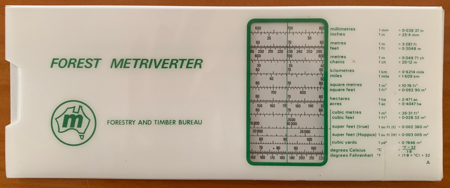
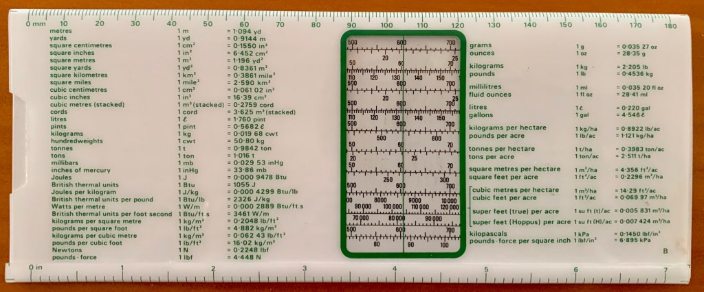
The Forest Metriverter slide-rule was issued by the Forestry and Timber Bureau to make metric conversions easier.
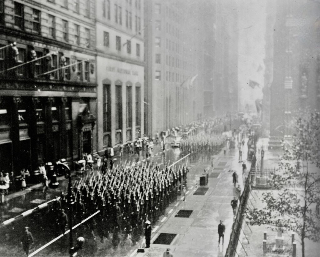
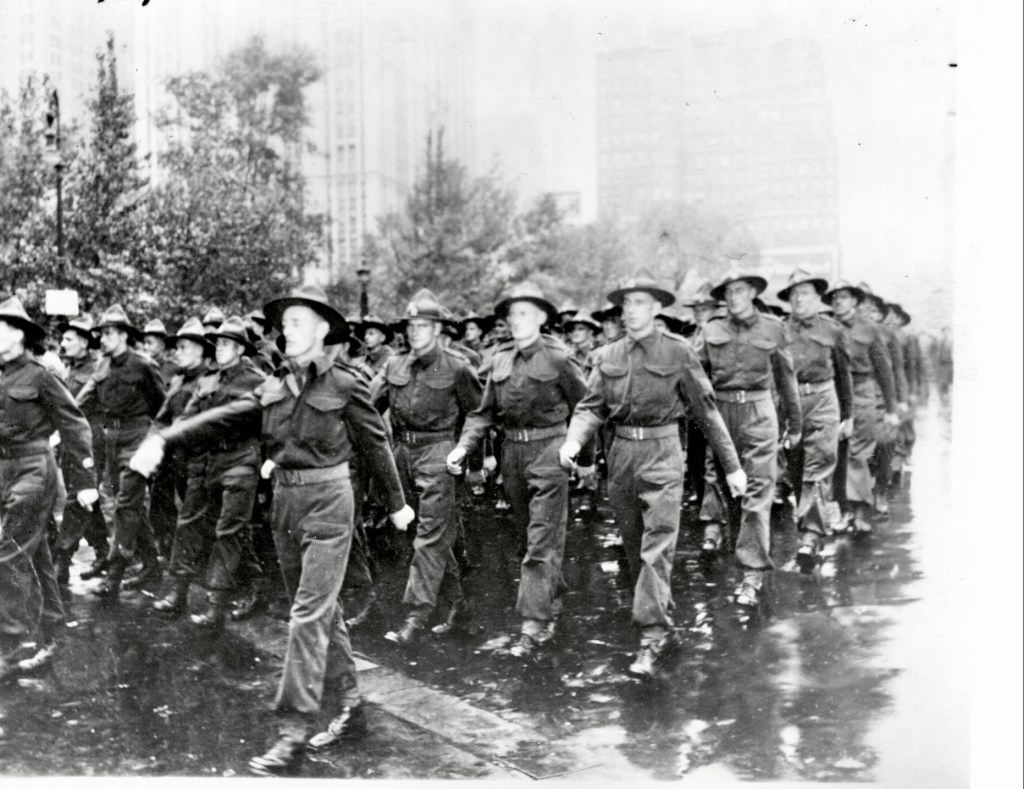
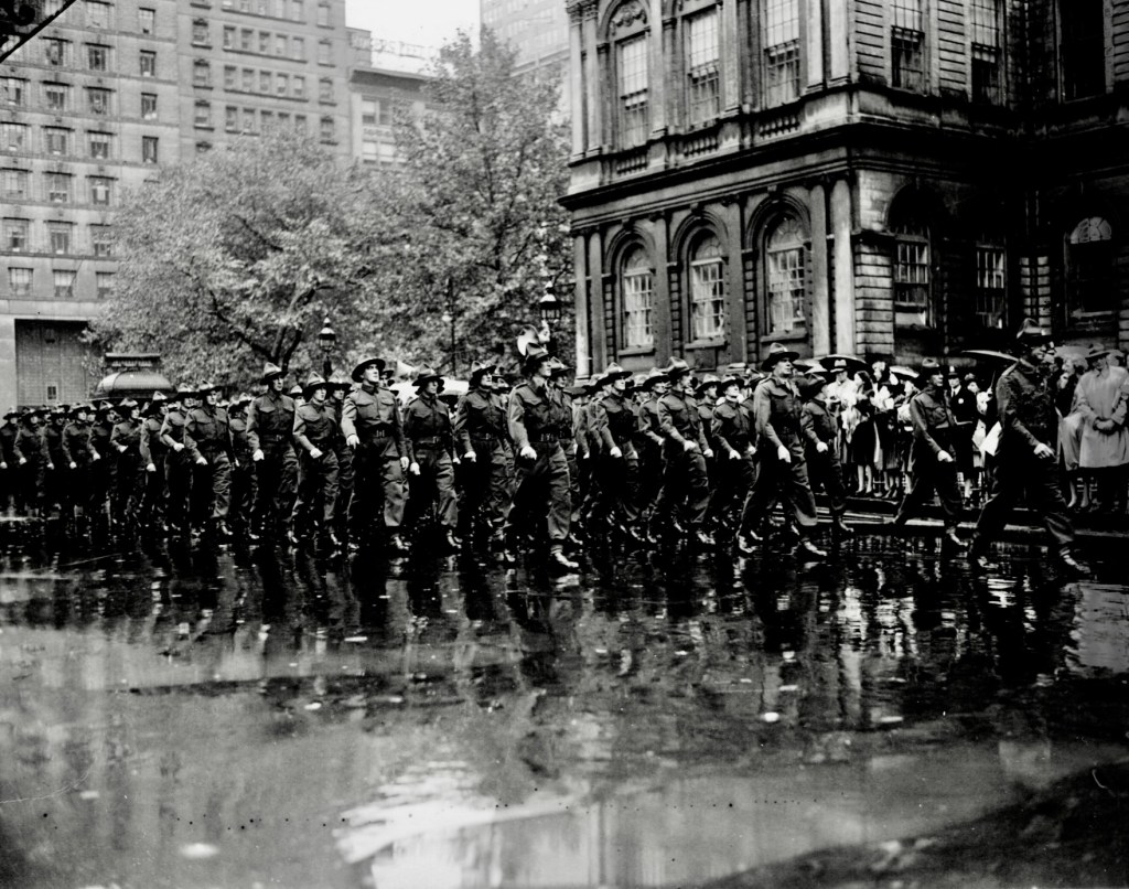
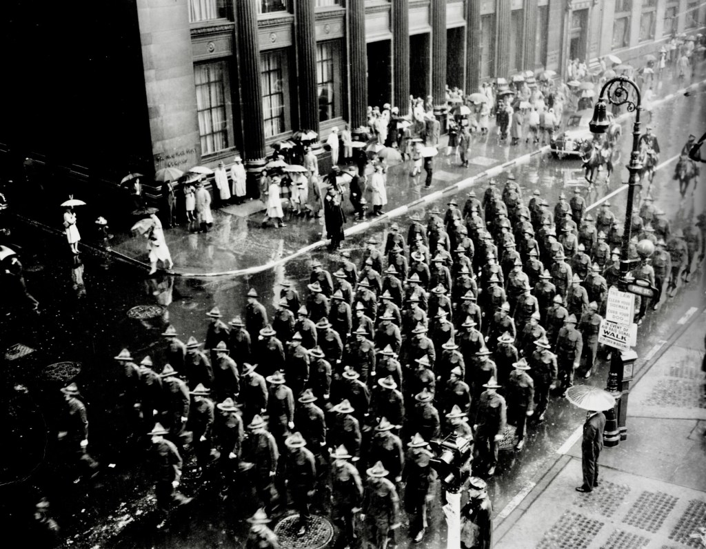
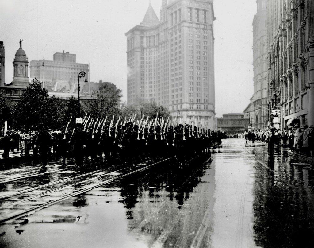
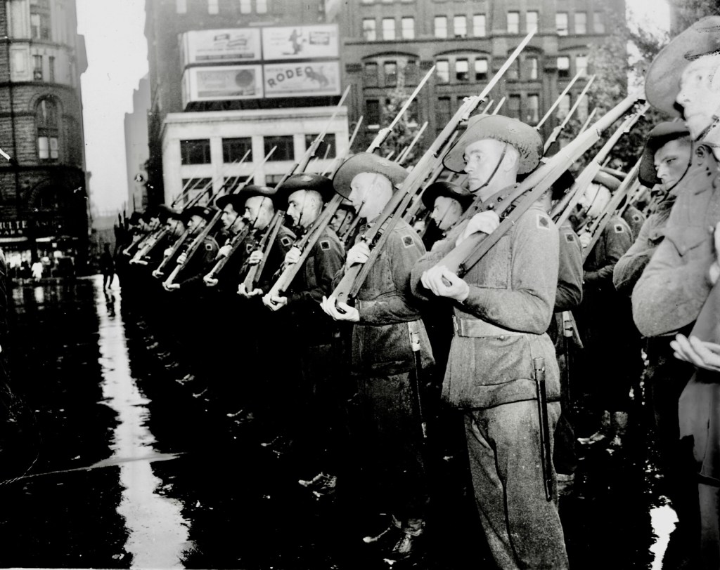
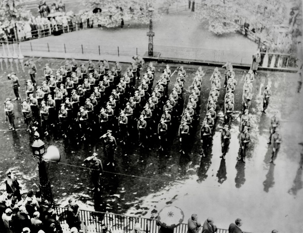
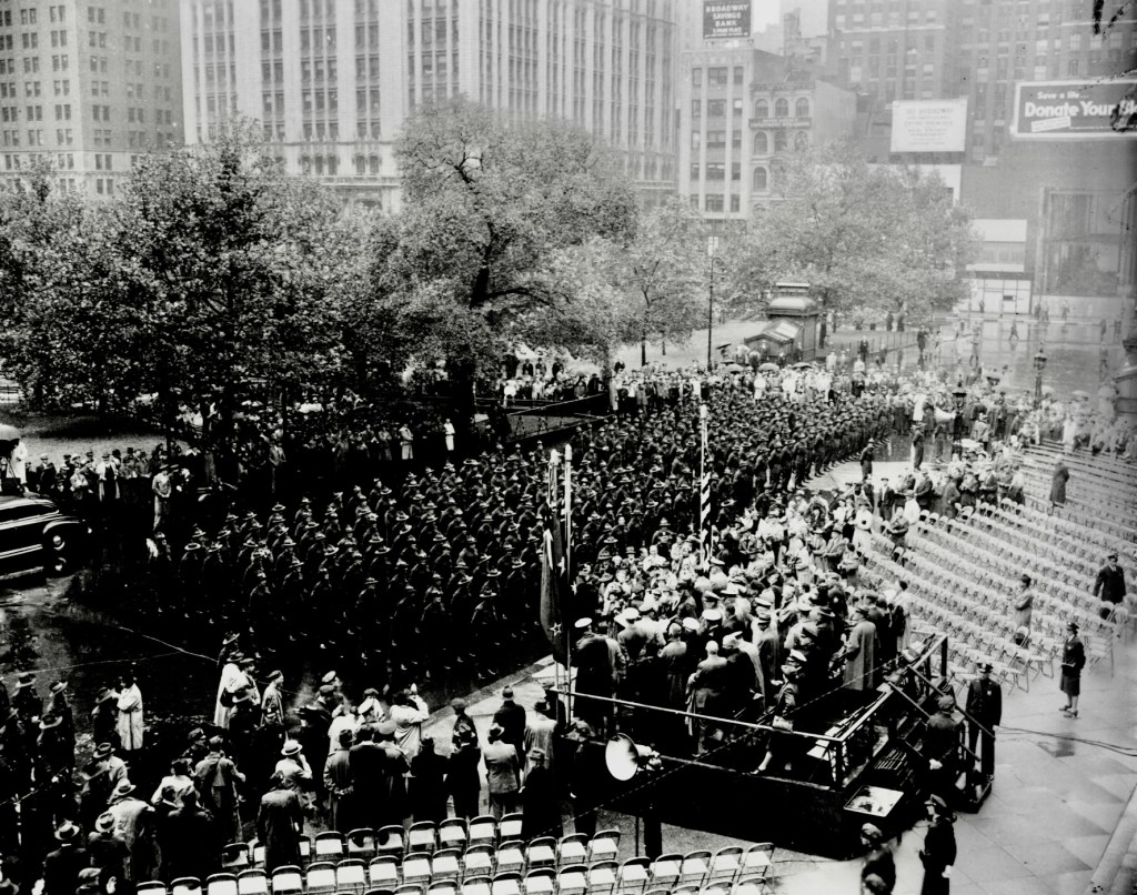
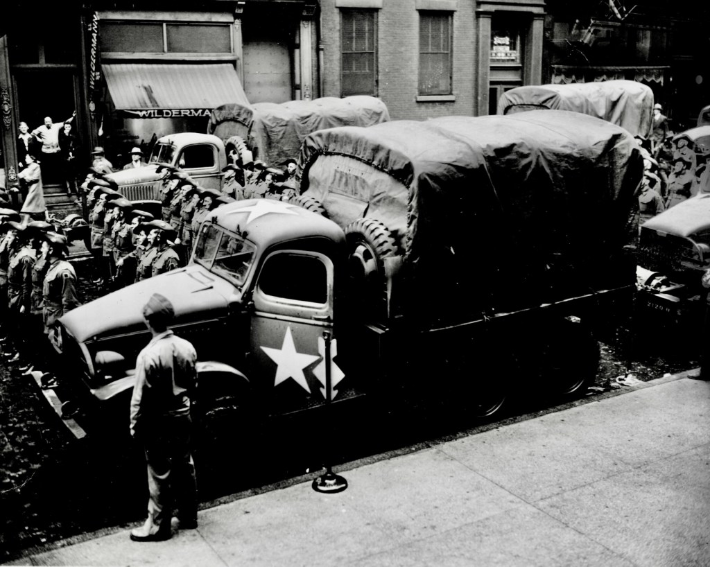
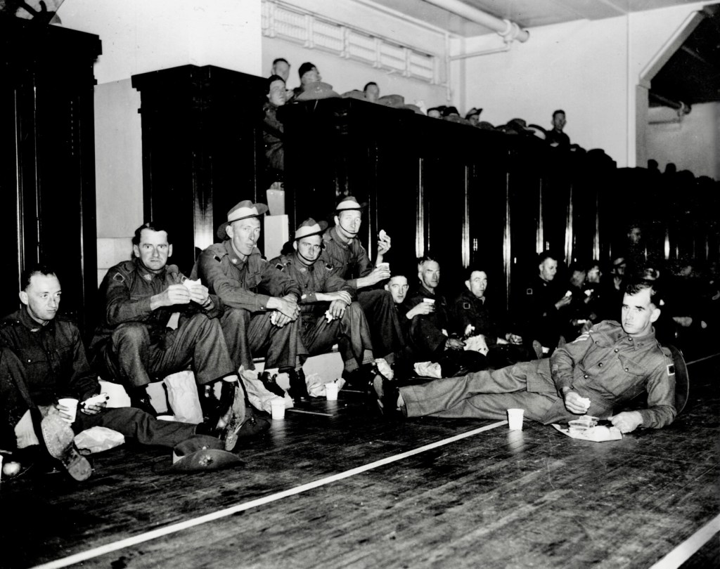
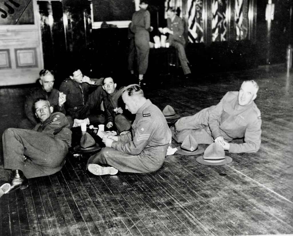
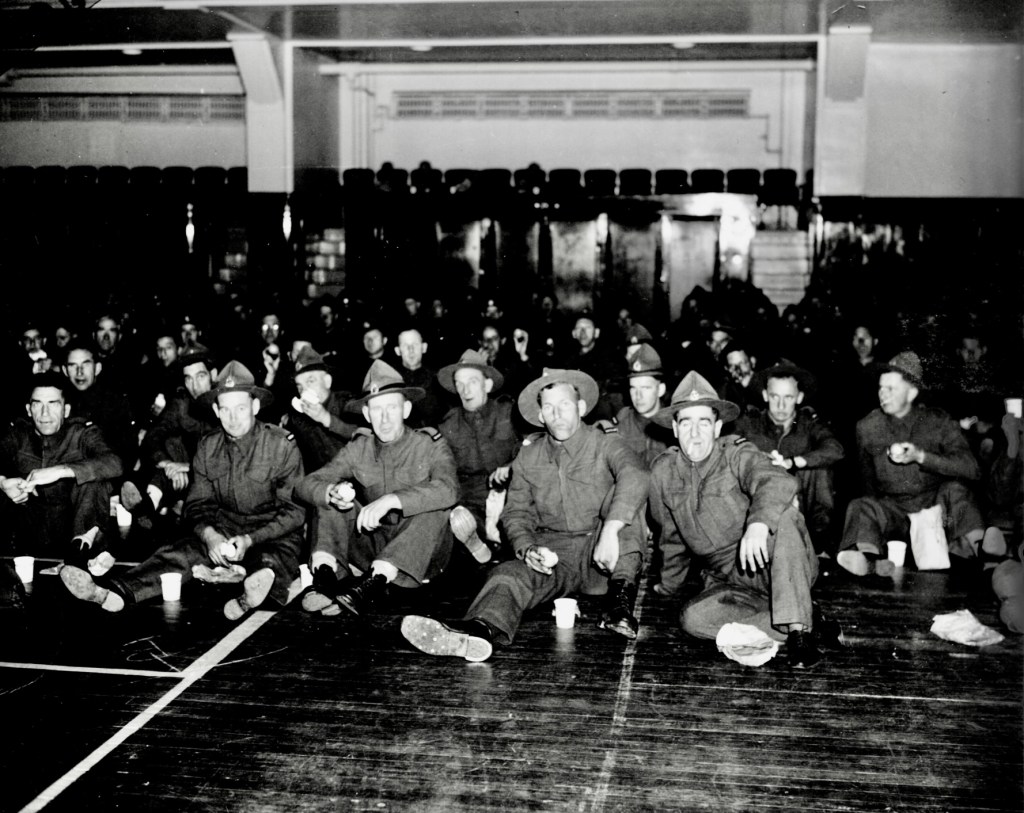
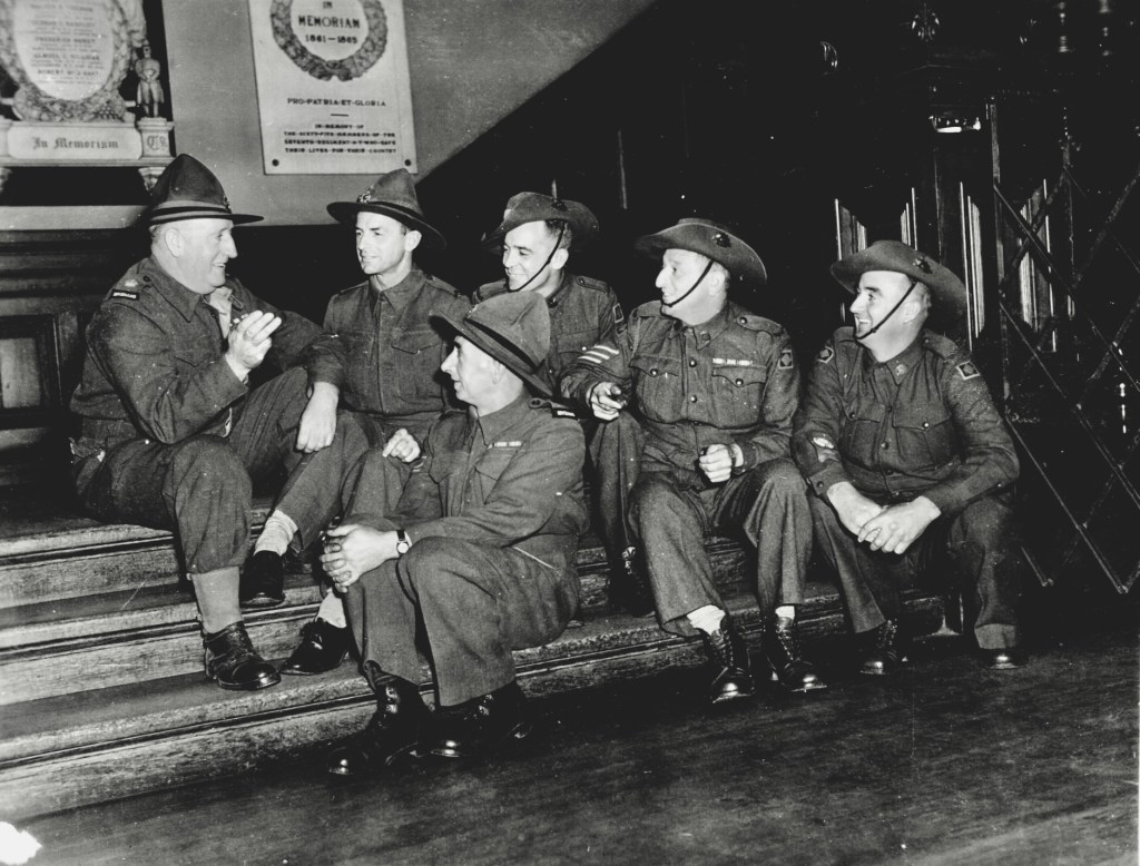
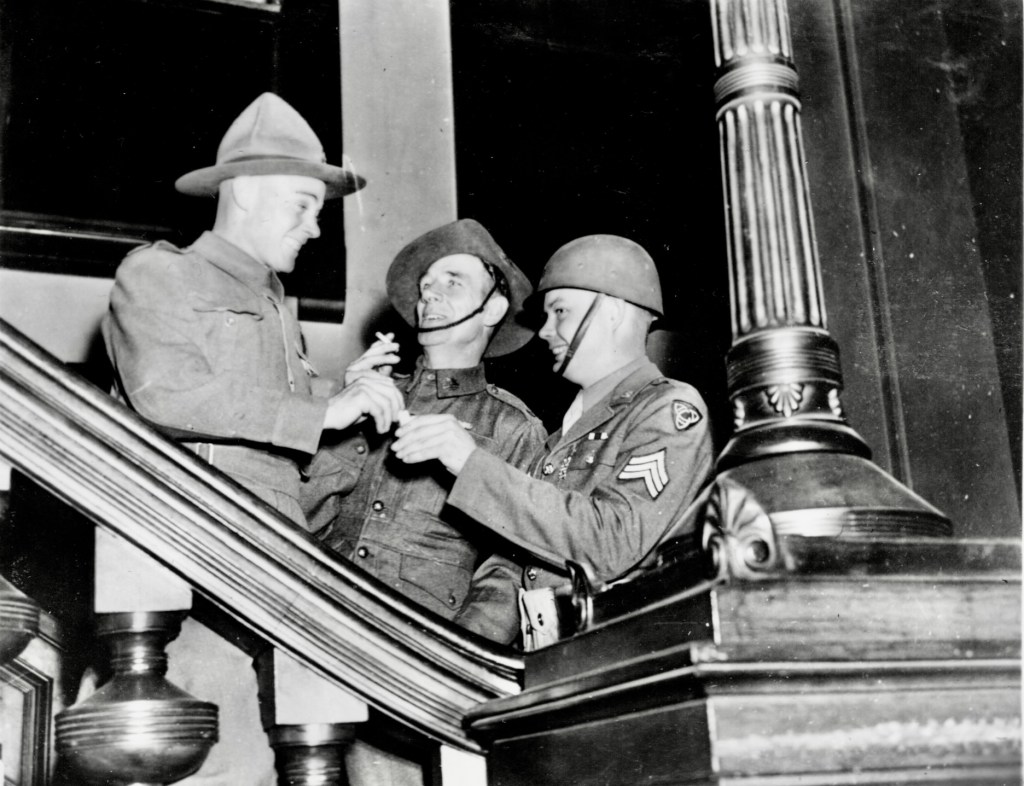
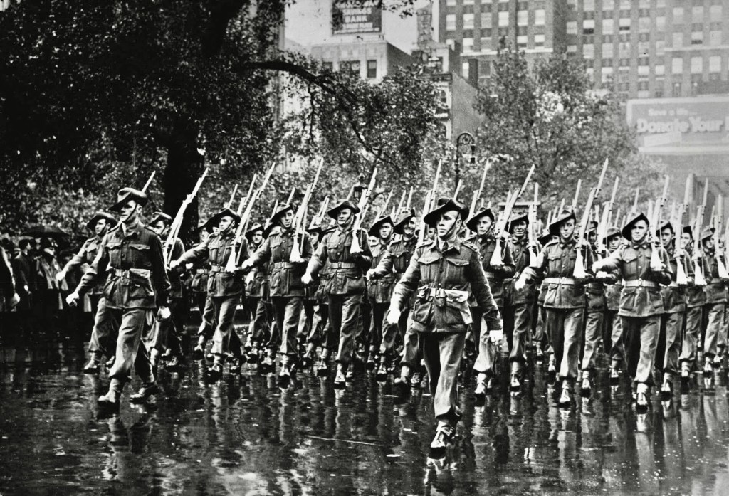
On Friday 1 October 1943, in the pouring rain, six hundred Australian and New Zealand forestry troops, en-route from England to their home countries, were given the unique honour of marching in a ticker-tape parade, with fixed bayonets down Broadway in New York.
It’s said to be the only occasion that armed foreign troops had marched through an American city since Independence.
They were officially welcomed by Mayor Fiorello H. La Guardia at City Hall, New York City. Speaking to the many female onlookers, La Guardia pronounced them “as manly a group as he’d ever seen”.
Mayor La Guardia asked the men to convey to the people of Australia and New Zealand the city’s assurance of cooperation in the war effort.
After the reception, the soldiers were taken on a shopping and sightseeing trip that took in the Yankee Stadium in New York City where they saw a NY Yankees Versus Chicago White Sox baseball game. Then a reception held at the historic 7th Regiment Armory, also in New York City.
The Australian contingent was the “Australian Forestry Group” an element of the Second Australian Imperial Force raised for forestry duties. Its constituent units were established in 1940 and 1941 in response to a request from the British Government for foresters to work in France. After the fall of France, the three Australian forestry companies were sent to the United Kingdom. The group headquarters was raised in July 1941. The foresters worked in northern England and Scotland and had a secondary military role.
The Australian Forestry Group returned to Australia via the United States in 1943, and its three companies later served in the Northern Territory and New Guinea.
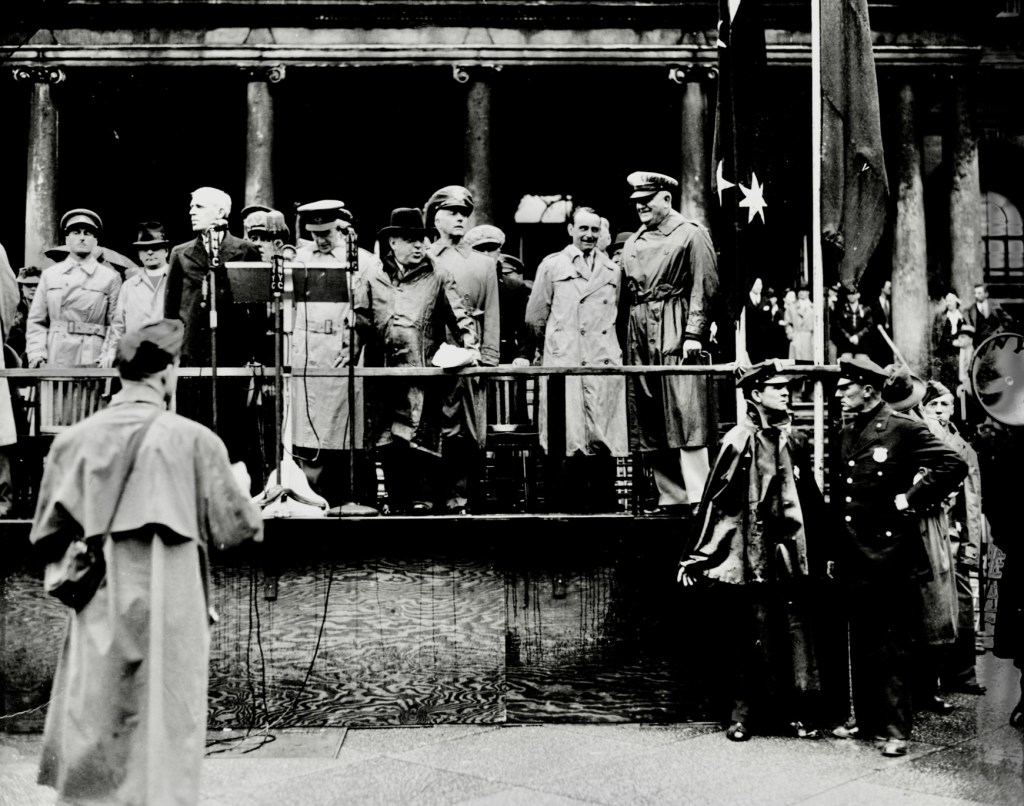
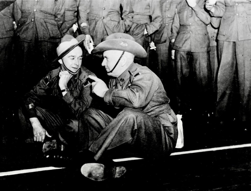
LTCOL Cyril Richard Cole was the Commander of the ANZAC’s, others on the reviewing stand are; BRIG GEN Troup Miller the US Army, Inspector General of the Eastern Defence Command – Sir Godfrey Haggard, British Consul – GEN Sir Owen Dickson Australian Minister to the US – GEN V.A. Sturdee, Chief of the Australian Military Mission at Washington the US Capital – Mayor Fiorello H. La Guardia of New York City and BRIG GEN Ralph K. Robertson of the US Army.Marching in the front row is Lt John (Jack) Godfrey Saxton from an innovative Victorian sawmilling family, who had survived the 1939 bushfires by sheltering in a dugout at Tanjil Bren. Source: AWM
Prior to the formation of the Alpine Resorts Commission (ARC) in 1983, Victoria’s snowfields were managed by a conglomerate of competing government agencies including the Victorian Railways, National Parks Service, Lands Department, State Electricity Commission and the Forests Commission Victoria.
The Forests Commission first developed a substantial interest in the development of Mt Buller as a major ski field from the early 1940s. The challenge of establishing roads, communications, water and sewerage, accommodation and other services in a remote location was well suited to its experience and skills. The road to the Mt Stirling ski fields was built by the FCV in the 1940s.
Downhill skiing at Mt Baw Baw and snow play as well as cross country skiing at Mt Donna Buang, Mt Erica, Mt Stirling, Mt Wills and Lake Mountain near Marysville were also administered directly by the Commission, or through their Committees of Management.
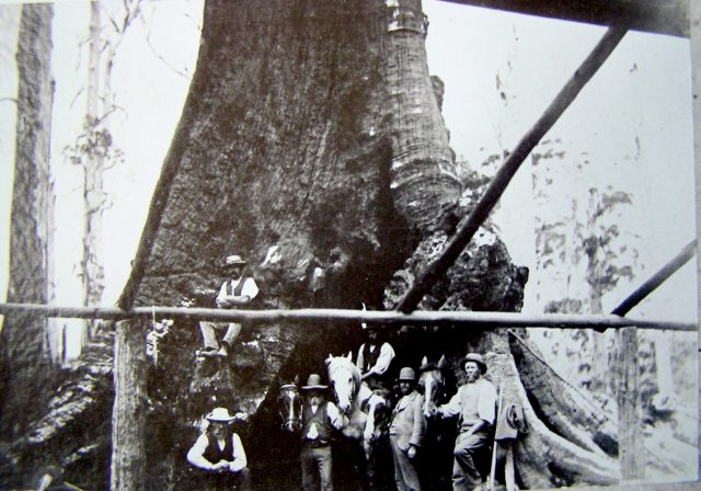
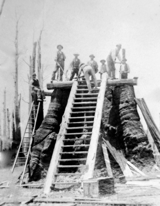
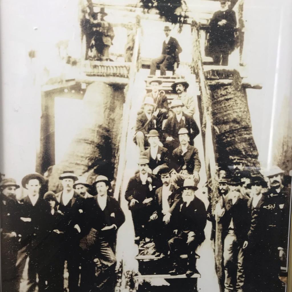
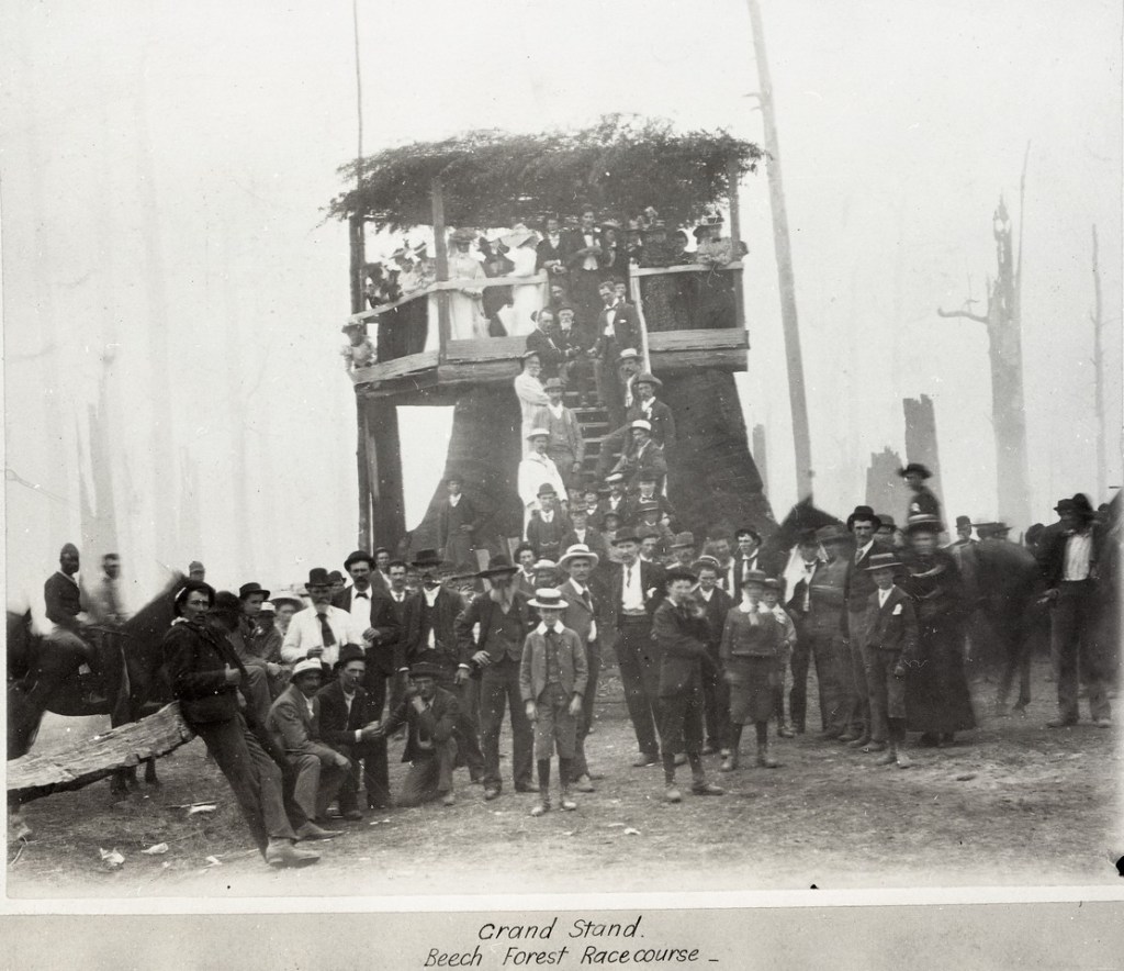
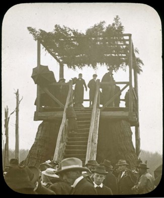
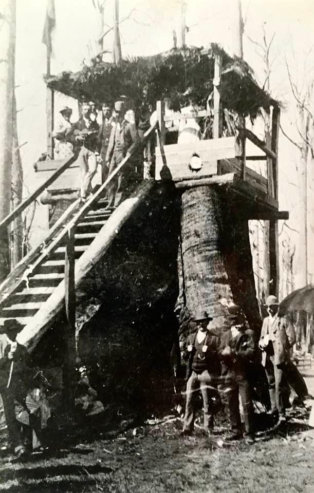
Most of the large and significant trees in Victoria were found in the mountain ash forests of the Otways, Strzelecki Ranges and the Central Highlands.
This enormous tree stump was converted into a Grandstand at the Beech Forest turf club in the Otways for their first race meeting in Easter 1893.
The Melbourne Cup had been introduced earlier in 1861 by the Victorian Turf Club.
The racecourse was set out on fairly flat land at Ditchley Park (not far from the existing football oval). There was a railway siding for spectators to alight from Colac and the steam train also pulled carriages for visiting racehorses.
Legend has it that bushfires regularly destroyed the steps, railings and roof of the stand so they were repeatedly renewed.
The Grandstand under construction. Source: SLVThe Grandstand under construction. Source: SLVStump at Beech Forest 1893 which doubled as a grandstand. Photo: SLVAnnual Beech Forest race meeting 1904, Photo: Victorian School of Forestry, Creswick Campus Historical Collection https://omeka.cloud.unimelb.edu.au/cchc/items/show/5146Flynn, John. (1912). People gathered on and around a platform built over a large tree stump. Link to other photos of the same stump. https://nla.gov.au/nla.obj-142375657/viewThe Colac Herald, 31 January 1893. https://trove.nla.gov.au/newspaper/article/87655162