Many seasoned firefighters advocate for a return to the methods used in the 1960s and ‘70s when the Forests Commission lit small spot fires on main ridges in the back country during autumn and let them trickle down the slope and go out overnight, or in a day or two.
These small, widely spaced spot fires were lit late in the day when the temperature and wind was dropping and the RH was rising, so they would burn slowly outwards in circles and either join-up or fizzle-out late in the evening. Flame heights were deliberately kept low, which resulted in minimal tree crown scorch. The burns were patchy (~70 – 80% coverage) so the fuel was reduced but not eliminated.
Fuel reduction burns in late autumn and early winter, on the top one third of the north facing ridges, is easier to achieve and very effective at breaking up the broader forest landscape into manageable blocks.
Importantly, these burns would often extinguish themselves up against natural boundaries like rocks or creeks, boundaries like roads and tracks, or shady areas on southerly aspects.
They were planned to adjoin areas that had been fuel reduced a few years earlier to create an interlocking mosaic. A bit was burnt each year, so they became multi-aged and often left unbounded (not requiring a hard-edge burn perimeter).
Ridgetops are generally where lightning strikes during summer (See: Gippsland Zig-Zag). Reducing this fuel can keep fires small and close to the point of ignition which gives a better chance at early suppression.
If first attack fails, often the only safe strategy is to build major fallback lines in combination with backburning and patrol that can take weeks or months. This also brings additional costs of control and rehabilitation.
Ridgetop burning helps keep the fires contained in the bush rather than letting them come out of the forest into the cleared farmland.
The objectives of landscape burning are different from asset protection works which are generally closer to towns and settlements. In conjunction with slashing and mulching, the frequency and intensity of asset protection works are more significant.
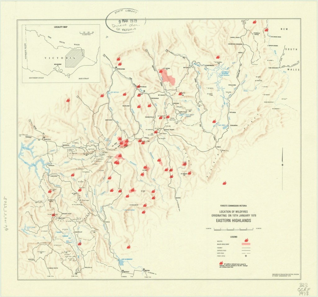
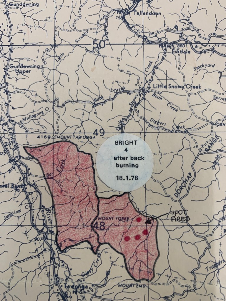
Alpine fires of January 1978.
Rainfall in northeast Victoria in the six months prior to the summer of 1977-78 was only 298 mm, which was the lowest since 1938 when 254 mm fell. West Gippsland had 361 mm compared to 261 in 1938.
Unsurprisingly, the summer was characterised by a build-up of extreme fire danger with 606 outbreaks within the Fire Protected Area (FPA)
Sunday the 15 January 1978 was a day of Total Fire Ban with hot northwest winds from the early morning. Temperatures reached into the high thirties and low forties. All Forests Commission Districts had been put on high alert with crews on standby.
A typical strong southwest change crossed the State late in the afternoon with intense thunderstorms and lightning, but little rain.
Before the cool change arrived, the Commission was involved in nine other fires and was supporting the CFA at a grassfire near Paynesville where two CFA volunteers were killed.
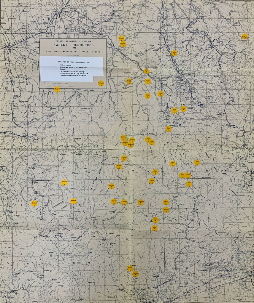
Reports slightly differ, but the lightning caused a spate of at least 88 fires in the mountains, with most being reported on Sunday evening and throughout Monday from FCV towers and reconnaissance flights.
Most of the major fires were in the remote mountains of the Bright, Myrtleford, Heyfield and Maffra Forest Districts. The more accessible fires were quickly brought under control.
The Forests Commission was severely stretched, and Stage 2 of the State Disaster Plan (DISPLAN) was implemented, enabling the Army and Air Force to be called to assist the 850 Commission employees and contract timber industry workers. The Country Fire Authority, State Emergency Service, State Electricity Commission, Transport Regulation Board, Lands Department and the Police, also contributed significantly.
Eleven different FCV control centres were established (this was an era before AIIMS). The Army assisted with five mobile cooking teams at base camps. A total of 25 bulldozers were deployed including logging contractors.
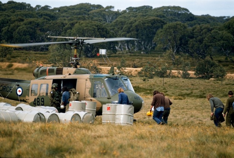
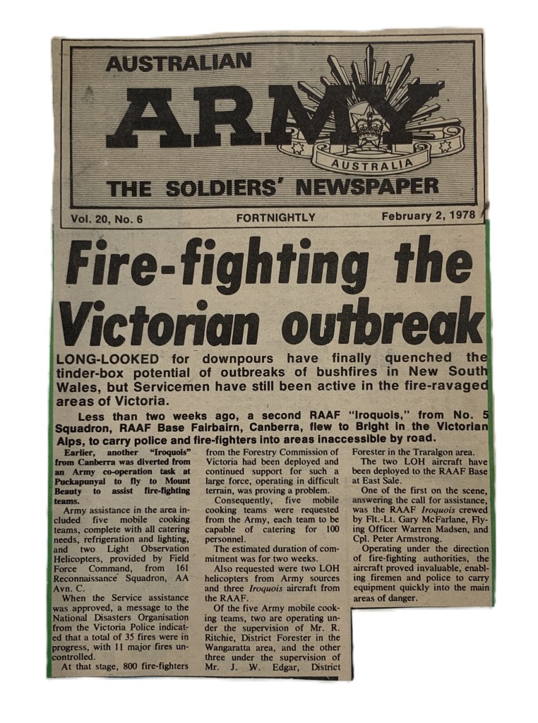
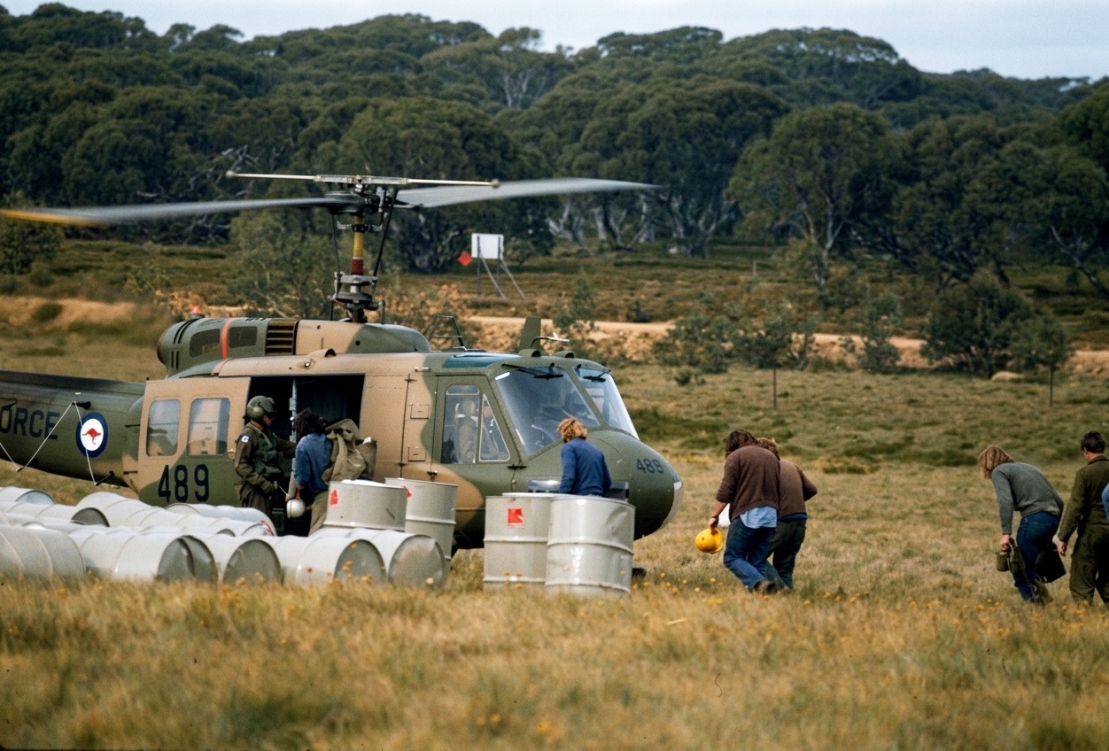
A notable feature of these fires was the very important role played by large military helicopters in moving men and supplies to combat multiple fires in rugged terrain.
This was probably the first time that large military helicopters had been used to support Australian firefighters on such a scale. It proved a “game-changer”
The Departmental Hughes 500 helicopter, which had been working at Toolangi, was immediately redeployed to Mt Beauty. Two other small helicopters were contracted by Monday evening. On Tuesday, the SEC had obtained access to an RAAF Iroquois which was then made available to the FCV under the State Disaster Plan arrangements. A further two heavy lift RAAF Iroquois, plus two lighter Army Kiowas arrived on Wednesday.
New helipads were cut, but crews were still walking up to four hours to get to some of the remote and inaccessible fires.
The RAAF Iroquois proved ideal for crew transport and could take up to 7 passengers and airlifted over 100 people over the course of the fires. They could also winch equipment and fuel drums. In one example at Mt Feathertop, the deployment times were reduced from a 6-hour drive, plus an arduous walk, to a short 15-minute flight back to the camp at Mt Beauty. This not only increased the amount of useful on-ground work, but reduced fatigue on crews and damage to vehicles.
But managing, refuelling and dispatching multiple crews and equipment to 12 different bushfires using the 8 helicopters proved a major logistical challenge for the Commission. But a lot was learnt for the future.
Five small agricultural aircraft were also used for firebombing. Four were based at Snowy Range and one at Mt Beauty, and together they dropped a total of 201 loads to support on ground crews using hand tools in the rough and steep terrain. While several fixed wing aircraft were also used for reconnaissance and transport.
Helicopters were not used for firebombing in 1978 but were available five years later in November 1982 at Seaton when the NSCA at West Sale fitted a large Bambi bucket to one of its medium helicopters. Belly Tanks weren’t introduced until about 1984-85.
A lot of valuable equipment was lost during these fires and chainsaws were sometimes left in the bottom of gullies and never recovered.
Most fires were extinguished or controlled by the following Sunday when some light rain fell (< 5mm) across the fire ground making 4WD tracks slippery. However, the underlying drought index remained high.
Rain later in March 1978 eased the fire situation and the season came to an end with general rain during April.
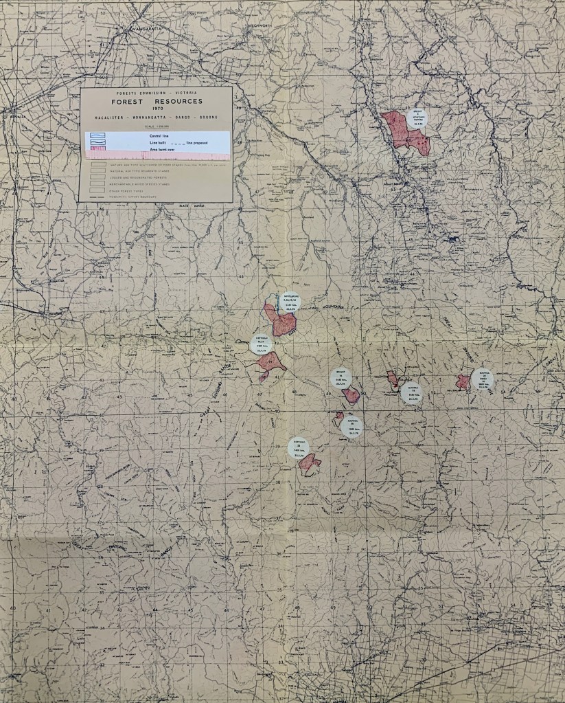
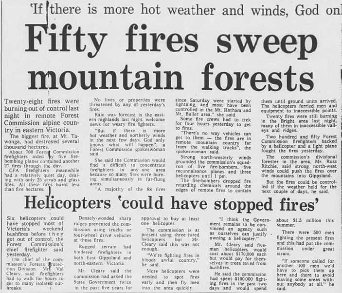
Unlike more recent alpine mega-fires, the total area burnt was only 23,000 ha, with 20,850 ha in 8 major blazes, and the largest at Mt Tawonga covering only 8,200 ha.
The Forests Commission’s Chief of the Forest Protection Branch, Val Cleary, made another public plea to the State Government for a more permanent fleet of bushfire helicopters. An internal review followed but with no direct change other than the existing single light helicopter on contract.
In the review of the fires, the FCV Chief Fire Officer, Barry Johnston, noted on 6 February 1978 –
Despite the amount of equipment employed, a large percentage of the perimeter of many fires had to be controlled by the use of hand tools. One particularly difficult fire on Mt Feathertop was entirely controlled by hand trails.
This work was facilitated by the number, training, willingness, youth and fitness of the additional men engaged earlier as additional manpower for firefighting.
Landscape Burning.
Importantly, in the decades prior to the summer of 1978 the Forests Commission had achieved a progressive increase in the area of Fuel Reduction Burning (FRB). While the annual figures varied according to the seasons, the rolling average had increased over the previous five years from about 150,000 ha to 200,000 ha per year.
This meant that nearly one million ha of forests had been treated by burning, leaving fuels at reduced levels and generally less than five years old. Most of this burning was low intensity in autumn along ridgetops in the eastern ranges.
There are some critics of FRB that claim that remote back country burning is ineffective and irrelevant. But in my experience, this prior landscape burning undoubtedly played a major part in the rapid success of the 1978 fire suppression effort.
Reducing fuel can also be very effective at giving safer access to crews, or as “anchor points” to tie in fallback lines and large-scale backburning when indirect attack is needed.
Importantly, most of the lightning strikes in January 1978 occurred on remote ridgetops in the lighter, sparser and recently burnt fuels.
The lower fuel levels not only reduced fire intensity, flame heights and rates of spread, but the more open forest allowed hand crews to gain access to the seat of the fires and then cut fire trails with hand tools or with small first attack dozers (FADs). This quick action combined with aggressive first attack kept most of the fires small and contained on State forests. No lives or private property were lost.
For all sorts of reasons, the area of landscape burning steadily declined from the mid-1980s. There was also a shift from prevention to response with a greater reliance on firebombing aircraft and indirect attack.
It therefore seems reasonable to conclude that the relatively small area burnt in January 1978 was due to the amount of landscape and ridgetop burning done in the previous five years.
Compare the 1978 outcome to the later megafires at Caledonia in 1998, the repeating alpine bushfires of 2002-03, 2005-06, 2006-07, Black Saturday in 2009, Aberfeldy/Seaton in 2013, the Snowy River Complex in 2014 and then Black Summer 2019-20, where preventative landscape burning had significantly declined.
And finally, there were so many bushfires that summer that the Forests Commission didn’t have enough money to pay all the overtime owed to staff. We had to wait until 1 July and the new financial year but then got whacked by the taxation department.
I know, because I was there…
Corryong – 1978.