History has shown that after each major bushfire, particularly if there has been a significant loss of life and property, there are vocal calls from affected communities and media commentators for State and Local Governments to stop further land subdivision, to apply restrictive building standards and buyback high-risk homes on the forest fringe.
The Black Saturday Royal Commission in 2009 was no exception and controversially recommended “retreat and resettlement” as a strategy to move people away from the urban/forest interface.
But the most notable and sustained buyback scheme commenced in the Dandenong Ranges after the 1962 bushfires which killed 33 people and destroyed more than 450 homes.
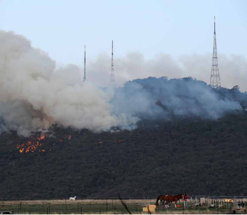
Areas of high fire risk such as the steep and exposed western face of the Dandenongs, just below the prominent TV towers, were identified. Conservation value was also an important criteria for purchase.
But the decision came with considerable heartache…
The buyback proved divisive with a mixture of voluntary and targeted acquisition which did not please everyone.
It was also complex and emotionally fraught with local District Foresters Jim Westcott, and later Frank May, often on the receiving end of residents anger and frustration over their broken dreams and fears of diminished property values.
Jim Westcott was later awarded an MBE in recognition of his service to conservation, fire protection and community affairs while in the Forests Commission.
While some left willingly, some residents simply refused to budge, but more deadly bushfires in 1968 strengthened the Government’s resolve.
Behind the scenes, Bill Borthwick who was the influential and well-respected local Member of State Parliament between 1960 and 1982, lobbied effectively to sustain momentum, focus and funding throughout his tenure.
The buyback program ended in about 1984, coinciding with a change of government, by which time it had quietly and patiently purchased thousands of vacant allotments and hundreds of family homes that were demolished, and the land reforested.
The only evidence today being the occasional broken brick or rogue garden plant.
The purchased land and its fire protection liability returned to public ownership, but the fragmentation of the private land interface adjoining State forest reduced as allotments were progressively consolidated. The Dandenong Ranges National Park was proclaimed in 1987.
Some significant and historic properties were procured including the magnificent Doongalla Estate at the foot of the Dandenongs earlier in 1950. The original mansion consisted of 32 rooms and was built in 1892 but was destroyed by a bushfire in 1932. The stables, servants quarters, gardens and about 300ha of forest are all that remained.
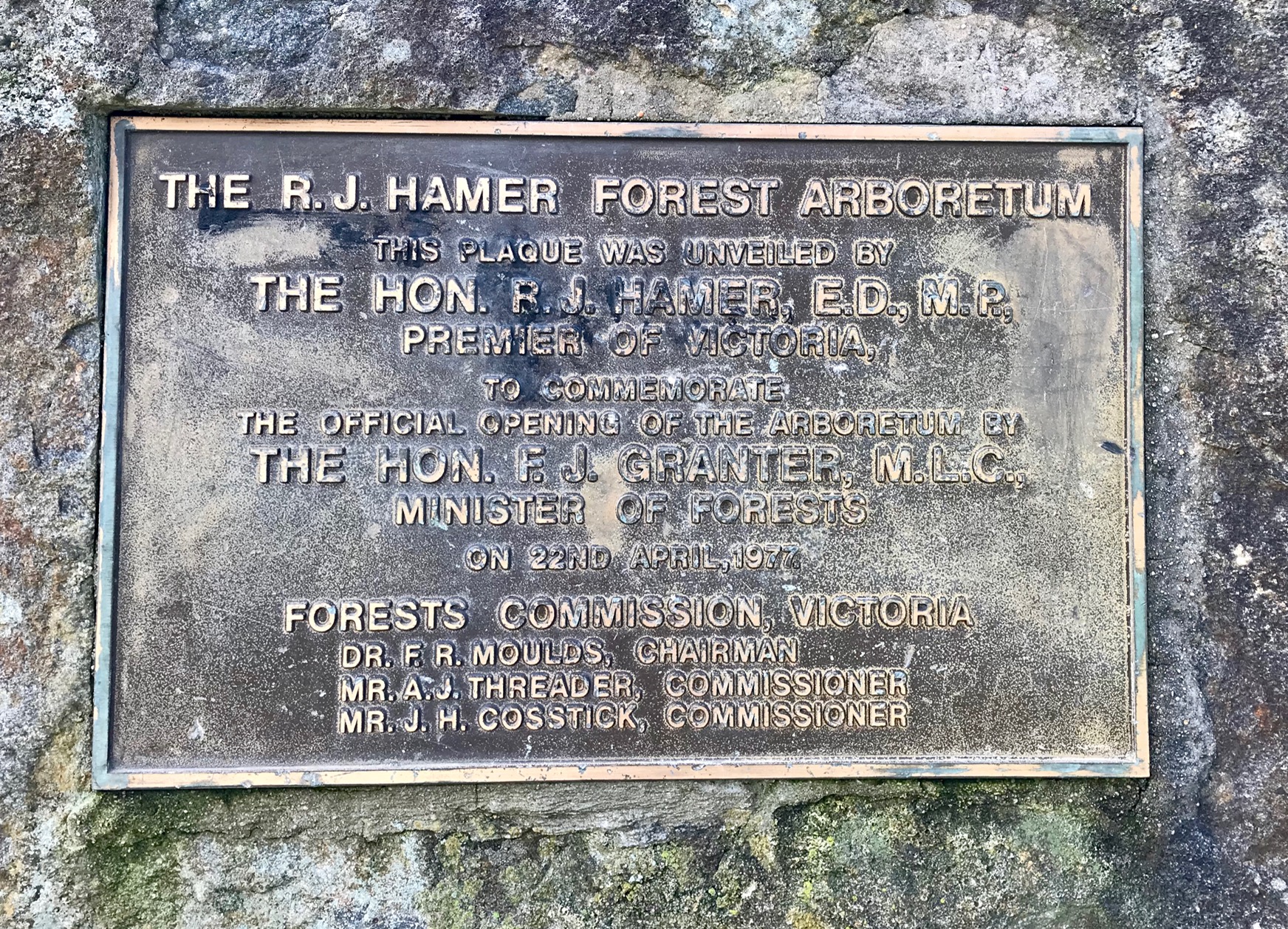
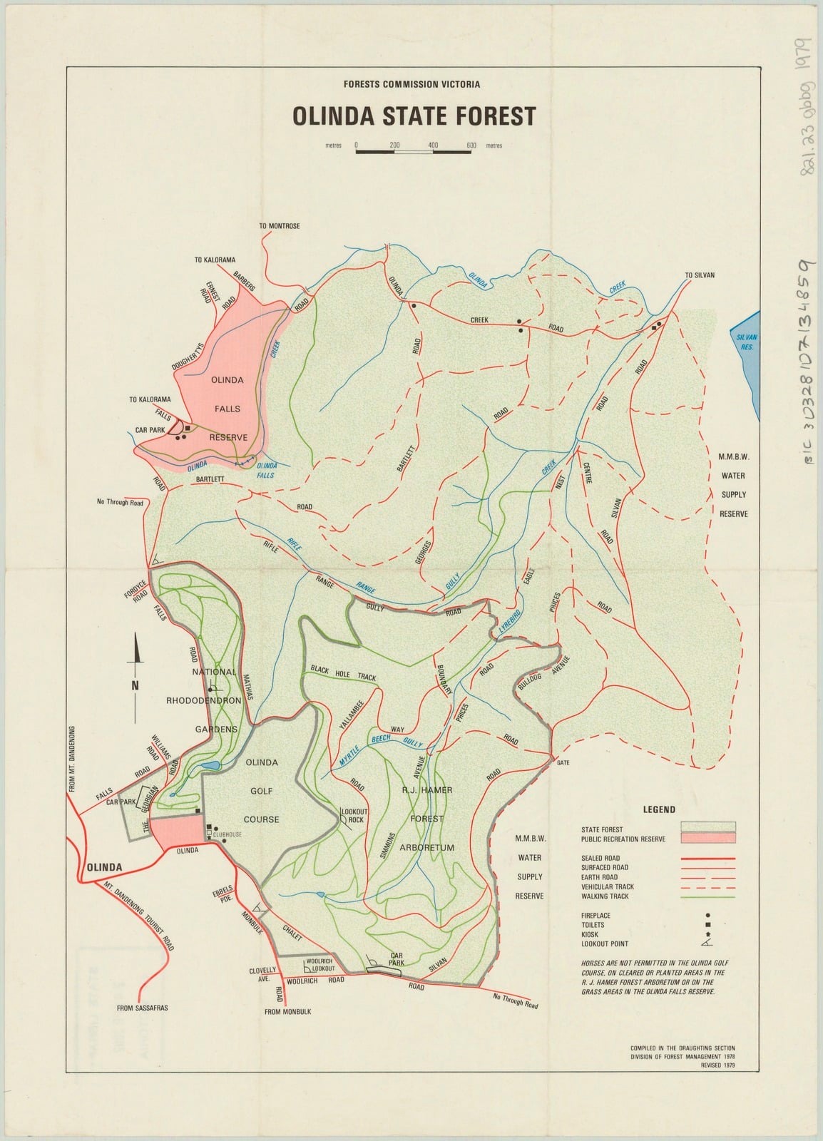
A large Forests Commission pine plantation at Olinda was also burnt in 1962, and after a lengthy period of procrastination, local FCV crews began replanting the 192 hectares in the mid-1970s with exotic and less-flammable species such as oaks and elms.
The resultant R. J. Hamer Forest Arboretum was opened on 22 April 1977 in honour of the State Premier who had supported its development and who was the patron of the “Victoria – The Garden State” campaign.
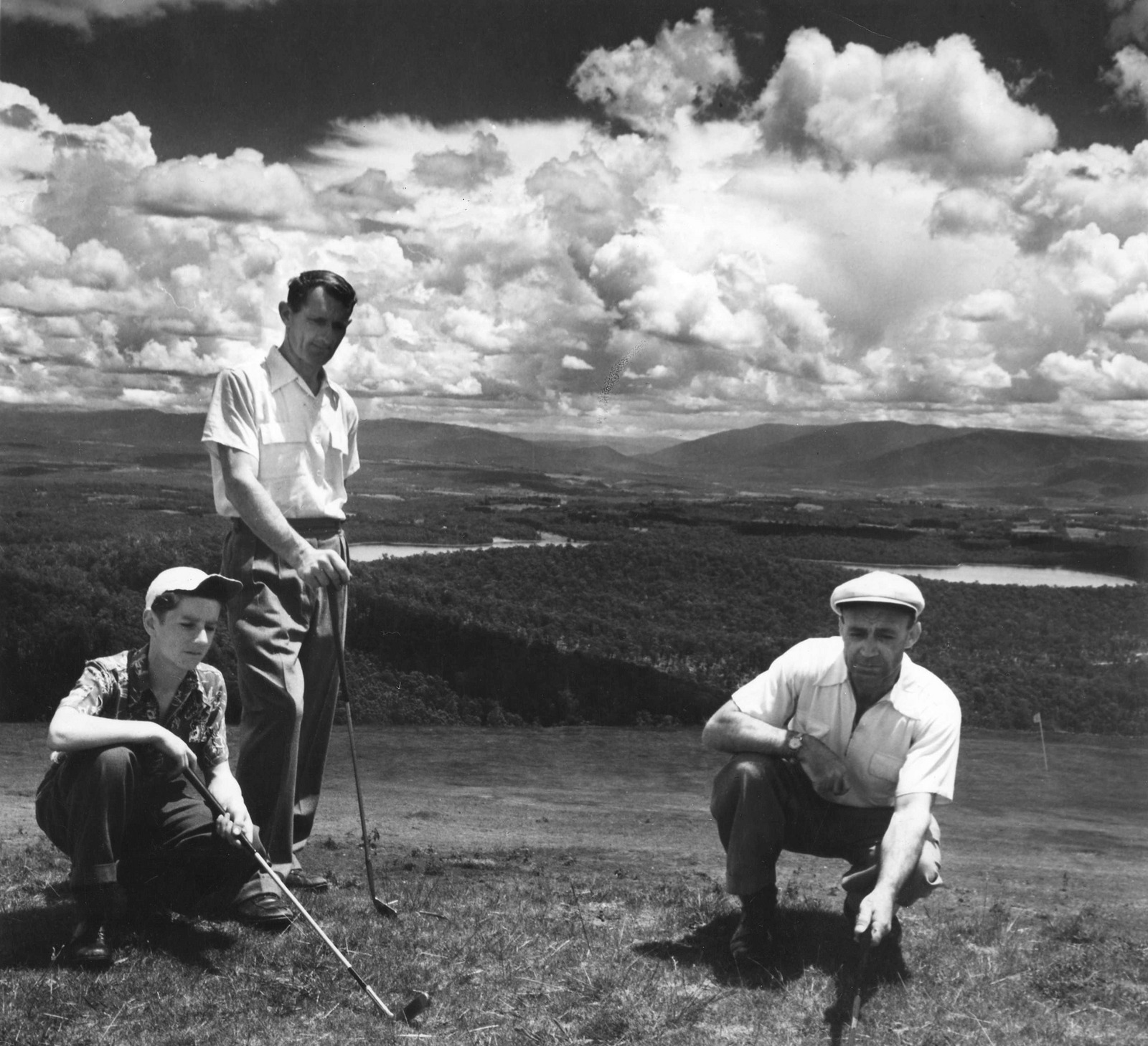
The Arboretum adjoined the 34-hectare Olinda Golf Course, Olinda Recreation Reserve and the National Rhododendron Gardens, which collectively acted as a unique strategic firebreak.
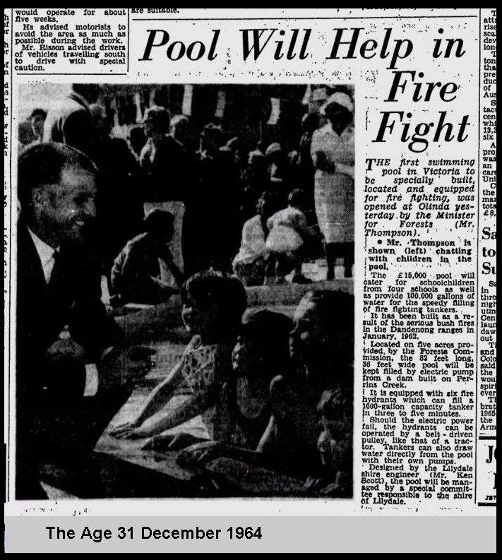
The Olinda Swimming Pool was also built after the 1962 bushfires as an emergency fire dam.
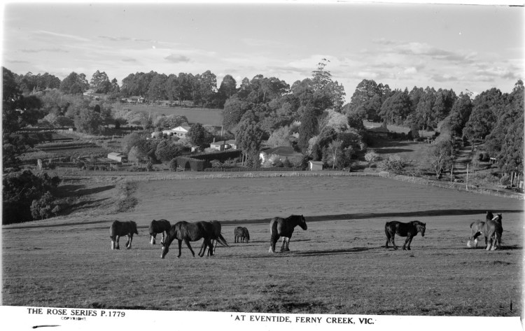
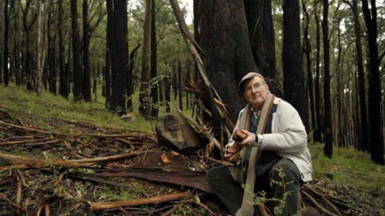
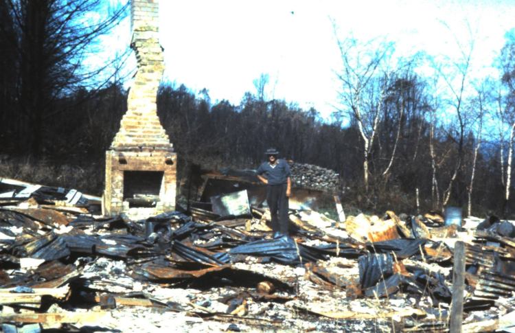
The Holly Hill Estate at Ferny Creek is just one of many typical early subdivisions in the Dandenong Ranges. The auction in 1918 was targeted at families wanting to escape the city and many settled to the area. The buyback of 20 allotments totalling about 30 acres on the steeper western side of Clarke Road began in 1962 and ended in about 1984. The remaining 56 blocks to the eastern side of Clarke road are flatter and less fire-prone so the houses were not targeted for acquisition. The cleared Nicholas Horse Paddock in the southern corner was purchased in 1976. Map: State Library. http://handle.slv.vic.gov.au/10381/169557On the western side of Clarke Road at Ferny Creek the land is steep and a greater fire hazard, so it was targeted for purchase. The houses were demolished, and the block reforested. Sweet Road disappeared altogether. The large 40-acre Nicholas Horse Paddock was purchased in 1976 and remains grazed as a strategic firebreak. The buyback program ran until about 1984 and the land is now incorporated into the Dandenong Ranges National Park. Source: DELWP MapShareView looking east towards the junction of Clarke Road and the Mt Dandenong Tourist Road from the Nicholas Horse Paddock. This 40-acre block was purchased in 1976 and is deliberately kept grazed as a strategic firebreak. Circa 1940s. Source: State Library of Victoria. http://handle.slv.vic.gov.au/10381/63782Peter Button sits sadly with some fragments of his first home in Ferny Creek which was acquired by the Forests Commission in the late-1960s. The land buyback scheme was an easy thing for politicians, local councils, bureaucrats and the media to say but it profoundly affected people and their families. The land that Peter once owned is now part of the Dandenong Ranges National Park. Source: Darren Grey, The Age – August 2010.The local Forests Commission foreman, Charlie Chamberlain, lost his Departmental house in Chalet Road at Olinda in 1962 as the bushfires roared up from the FCV pine plantation below. Photo of Charlie standing in the rubble courtesy of his son, Peter Chamberlain.The present R J Hamer Forest Arboretum at Olinda, which had been an FCV pine plantation prior to the 1962 fires, was opened by the State Premier in 1977. Source: FCV Annual Report.The R J Hamer Forest Arboretum plaque. Photo: Peter McHugh – 2019.
The National Rhododendron Gardens at Olinda was established on 100 acres of State forest with the assistance of the Premier Sir Henry Bolte and Commission in 1960. The site was adjacent to the Olinda Golf course and the R J Hamer Arboretum which together formed an important strategic firebreak. Source: FCV Annual Report.
The RJ Hamer Arboretum adjoined the 34-hectare Olinda Golf Course, Olinda Recreation Reserve and the National Rhododendron Gardens, which collectively acted as a unique strategic firebreak. The Olinda Swimming Pool was also built after the 1962 bushfires as an emergency fire dam. Source: DELWP MapShareForests Commission Olinda State forest acted as a strategic firebreak which ran east-west across the main ridge above Silvan reservoir. c 1979. http://handle.slv.vic.gov.au/10381/139815
One of the quirkier land parcels in the buyback program was the site of the Fox’s Point Scenic Railway which ran up the north face of the Dandenong Ranges near Kalorama. The now long forgotten railway was built by Mr. Neil Foxcroft in about 1953 to carry building materials up to his house and was later converted into a tourist attraction which ran until 1961. Passengers travelled 200 feet along the tracks lifting them 110 feet to a kiosk and Fox’s Point Lookout, a steep slope of about 30 degrees. The tourist railway and Mr. Foxcroft’s home were all lost in the 1962 bushfires and the tracks dismantled in 1965. The land was purchased by the Forests Commission in 1974 after major landslips blocked the main road in 1972. Photo: Museum Victoria – circa 1955. https://victoriancollections.net.au/items/5600e69c400d0c1c70acd64c
“Invermay”, The Basin, Dandenong Ranges, circa 1890. Invermay was built in 1892 by Sir Matthew Davies in The Basin, part of the Dandenongs, using some of the first machine-made bricks in the colony and split timber walls transported to the building site on a purpose-built railway. Miss Helen Simpson bought the property about the turn of the century when she renamed it “Doongall”a, added stables and established a fine garden. T.M. Burke was the last owner when the house burnt down in 1930. Photo by Archibald James Campbell, part of the Museums Victoria Collection. https://collections.museumsvictoria.com.au/items/794793
Olinda Golf Course was on State forest. The softwood plantation is visible in the background near Silvan Reservoir. Photo: 1952. Source: State Library http://handle.slv.vic.gov.au/10381/337083From Lost Dandenong’s FB page
From Lost Dandenong’s FB page
The buyback program wasn’t universally popular amongst Dandenong Ranges residents, particularly as time passed, but more deadly bushfires in 1968 strengthened the Government’s resolve to persist. Photo: Museum Victoria. https://collections.museumsvictoria.com.au/items/801905A quick fill… topping up a knapsack on the Mount Dandenong Road during the 1962 bushfires.
The steep western face of the Dandenong Ranges below the TV towers was an obvious priority for the buyback program after both the 1962 and 1968 bushfires. Photo of a recent planned burn. Source: DELWP.A deliberately lit bushfire in January 1997 which killed 3 people and destroyed 42 homes came perilously close to the old Holly Hill Estate in Ferny Creek that had been bought back. (see smoke rising up gullies on the western face of the Dandenong Ranges on the left side of this aerial photo.A significant consequence of the success of the buyback scheme was the progressive increase in the length of firebreaks on State forest that needed to be slashed each year. The Dandenong Ranges National Park was proclaimed in 1987. Photo: Yarra Ranges Contracting.
Top Image: Their faces say it all…. with flames roaring down on them, two young women frantically loaded their father’s truck with bedding from their house in Butler’s Road in Lower Ferntree Gully on January 16, 1962. Source: The Age.
Are you based around here in the Dandenong Ranges?
I am from UK and came to stay with my family before Covid – ended up staying with my family in Sassafras, renting a place in The Crescent. My daughter then bought a small old wooden property in Mason Grove next to Rostrevor in Sassafras. Then in June 2021 a gum tree came down off the Council land and destroyed the house and their cars. We ended up renting again – this time in Ferny Creek in Wondoora Avenue. I took on the role of Secretary for the Hills Creative Alliance – a group that came together after the storm and we ended up doing community activities and now run a community magazine – Hills Community Focus.
I always felt unsafe here but not sure what I can do but be informed, and reading the blog that Robert Onfray had written just seemed to be real and straight. Not hidden behind a gung ho attitude of ‘well if it happens it happens’.
Currently I am trying to support the set up of a Township group for this end of the Tourist Road – Robert said you are busy to engage – so presumably you do live around here.
YRC are doing a range of things to prepare for the next disaster but difficult to get my head around how things happen. I have reached out to the CFA here in Sassafras – Ferny Creek and trying to bring together stories of the June 2021 storm into a book.
Anyway I am just replying.
Has the Mount Dandenong Historical Society got a copy of your research ? – I joined recently
Hi there.
I had an email from Robert this morning and I’m aware of your group.
I lived at Sassafras in Clarkmont Road next to the Kennon Church and worked in the Dandenongs as a forester for many years. I was involved in both fire protection and the buy back scheme
I moved away about 30 years ago and now I’m retired. I spend part of my time writing forest history like Robert
Im not sure if the historical society has a copy or not of my work but I reckon they would know about it. Im happy to share it
Cheers


Hi Peter
Are you based around here in the Dandenong Ranges?
I am from UK and came to stay with my family before Covid – ended up staying with my family in Sassafras, renting a place in The Crescent. My daughter then bought a small old wooden property in Mason Grove next to Rostrevor in Sassafras. Then in June 2021 a gum tree came down off the Council land and destroyed the house and their cars. We ended up renting again – this time in Ferny Creek in Wondoora Avenue. I took on the role of Secretary for the Hills Creative Alliance – a group that came together after the storm and we ended up doing community activities and now run a community magazine – Hills Community Focus.
I always felt unsafe here but not sure what I can do but be informed, and reading the blog that Robert Onfray had written just seemed to be real and straight. Not hidden behind a gung ho attitude of ‘well if it happens it happens’.
Currently I am trying to support the set up of a Township group for this end of the Tourist Road – Robert said you are busy to engage – so presumably you do live around here.
YRC are doing a range of things to prepare for the next disaster but difficult to get my head around how things happen. I have reached out to the CFA here in Sassafras – Ferny Creek and trying to bring together stories of the June 2021 storm into a book.
Anyway I am just replying.
Has the Mount Dandenong Historical Society got a copy of your research ? – I joined recently
All good wishes
Liz
LikeLike
Hi there.
I had an email from Robert this morning and I’m aware of your group.
I lived at Sassafras in Clarkmont Road next to the Kennon Church and worked in the Dandenongs as a forester for many years. I was involved in both fire protection and the buy back scheme
I moved away about 30 years ago and now I’m retired. I spend part of my time writing forest history like Robert
Im not sure if the historical society has a copy or not of my work but I reckon they would know about it. Im happy to share it
Cheers
LikeLike