The 12 February 1977 was described as “Black Saturday” as 69 fires broke out across Victoria. Five people were killed and 17 injured as 100 kilometre-an-hour winds drove fires statewide.
Most of the fires appeared to have occurred by power line failures caused by the very strong winds.
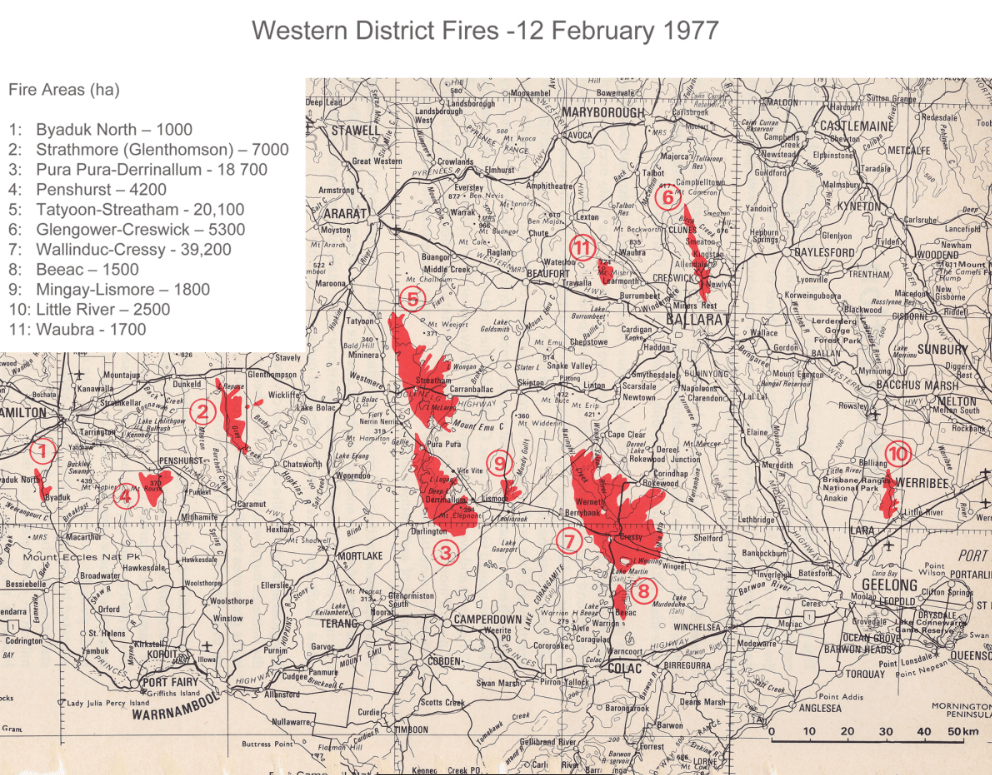
Eleven of the major blazes were in the Western District. The historic townships of Cressy and Streatham, west of Ballarat, were destroyed.
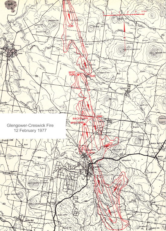
The Creswick fire originated at 1320 on farmland near the intersection of Weatherson’s Road and the Campbelltown – Clunes road, just south-west of Glengower.
A person later admitted to police that he carelessly dropped a cigarette into the long grass by the roadside and the fire spread rapidly. He was charged with offences relating to ignition of the fire on a day of Total Fire Ban.
The hot north winds sent the fire in a southerly direction.
CFA units included 49 tankers, while the FCV committed 130 men, 11 tankers, 4 bulldozers, a helicopter and a fixed wing aircraft, plus service staff and equipment.
Importantly, there were two long-distance spotfires which leapfrogged across the parched landscape. The first was near Wheelers Bridge at 1535, then another 10 minutes later at 1545, just north of Creswick near Wrigley’s Road
The map indicates a courageous attempt was made to put in a backburn on West Berry road near Allandale, but the fire slipped around the unburnt edge at 1600.
It was the second spotfire near Wheelers Bridge that raced about 2km in 30 minutes under the influence of the 60 km/hr northerly winds to reach the outskirts of Creswick North near the cemetery at 1610.
The fire swept near the Forestry School and Nursery and threatened the buildings. There were no students in the campus at the time.
The fire travelled a further 10 kilometres south through the bush until 1855, when the wind changed to the south-west.
The fire shape was long and narrow and travelled a total of 30 km. It was generally less than 3 km wide. Unlike many other fires on the day, it did not significantly break out on its eastern flank with the wind change.
Fourteen houses were destroyed, 6 of them unoccupied, together with 33 sheds and outbuildings. Although there was no loss of life or serious injury, there were several remarkable escapes.
The overall area was 5,300 ha with about 270 ha of pine plantations and 1,272 ha of eucalypt forest damaged, and many old and significant trees were lost.
Alan McArthur from the CSIRO later investigated the fires to understand their behaviour and the rates of spread, as well as the effectiveness of the suppression tactics.
Report of the Board of Inquiry into the occurrence of bush and grass fires in Victoria. https://exposed.net.au/barber.pdf