A simple working plan for the Grampians State Forest had been produced in 1939, but a new blueprint was prepared by Commission in 1974 which reaffirmed its core principles of balance and multiple use.
The document was an innovative attempt at the time to set out a vision for the 210,000 ha Grampians State forests
The plan follows a now very familiar format.
Firstly, the Grampians Forest Management Plan described in varying detail, the European and indigenous history, vegetation, climate, landforms, geology, forest types and land tenure.
It also described some of the uses of the forests such as recreation, bushwalking, camping, timber production and the need for fire protection works such as roads, lookouts and fuel reduction burning.
The plan set some noble goals including:
- Protection of forests and their associated vegetation and fauna from damage by wildfire and from injury by biological agencies.
- Protection of water catchments.
- Provision of a continuing supply of hardwood sawlogs and other products at a level which is consistent with the growth of the forests. (AKA sustainable yield).
- Provision of opportunities and facilities for public recreation and education. (It was estimated in 1974 that there were some 200,000 visitors to the Grampians each year).
- Conservation of landscape values, wildlife habitat, flora, historical and environmental values.
- Maintenance of the present area of softwood plantations to augment wood supplies from the hardwood forests to support local forest products industries.
- Provision of opportunities for apiculture, forest grazing and defence training where appropriate
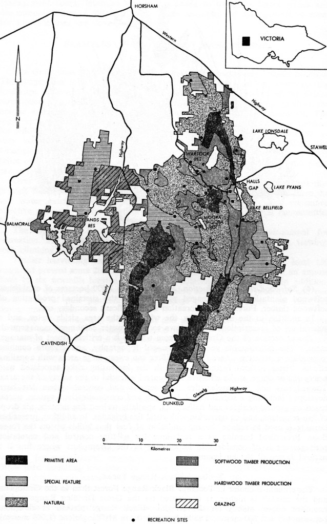
While the plan doesn’t identify, discuss, nor highlight conflicting objectives or uses, it sets out some management zones.
- Primitive Zone. Provision of opportunities for recreational experience in a natural environment without developed public access, and preservation of natural habitats where ecological processes can occur without interference. Existing vehicular tracks were closed to public access, with no utilisation of forest produce, on six separate locations covering 31 000 ha.
- Special Feature Zone. The primary objective was conservation of outstanding natural and historical features for recreation, aesthetic educational and natural history purposes. The natural flora and fauna were conserved. Forest produce was not to be utilised. It included the Wonderland Scenic Reserve which had been set aside under Section 50 of the Forests Act in the late 1950s. Developed access for protection and management purposes was in in 9 locations covering 32,700 ha.
- Recreation Sites Zone. Provided for 52 picnic or camping areas. Most of these were already in existence.
- Natural Zone. The primary objective was to conserve natural features, maintain the characteristic Grampians forest environment over a wide area of the mountains. Low intensity timber procurement and (for instance) gravel removal was permitted where it could be shown to be consistent with the primary objective. Apiculture remained permitted, along with dispersed camping in 81,900 ha throughout the ranges.
- Hardwood Timber Production Zone. The primary objective was sustained production of native timber in accordance with prescriptions governing harvesting, regeneration of the forest and protection of soil and water catchments and other values. Stringybark and associated species 34,600 ha, durable species 34,300 ha giving 69,900 ha in total.
- Softwood Timber Production Zone. Sustained production of softwood timber from two existing plantations covering 660 ha
The FCV’s plan was presented at a forum on 27 September 1975 at the Burnley Horticultural College which was chaired by Professor John Turner from the University of Melbourne. This was followed by a public meeting at Stawell with a field trip to the Grampians on the following weekend.
The proceedings were jointly hosted by the Forests Commission and the Natural Resources and Conservation League (NRCL).
The Chairman, Dr Frank Moulds, gave the keynote address and the State Premier, Rupert Hamer, also attended. Other agencies presented but It’s hard to know what other public consultation, if any, occurred during the management plans’ development, and to what to degree there was consensus about the objectives or mixed balance of uses.
The Plan was probably prepared to inform, and possibly forestall, the Land Conservation Council (LCC) studies of the southwest area and potential changes in land tenure.
The LCC investigations began in February 1976, and the descriptive report was published on 9 May 1979. The proposed recommendations were published in September 1981 and reflected the FCV multiple use submission outlined in 1974.
However, the final LCC recommendations in May 1982, only weeks after the State election, proposed a large National Park for the Grampians with only a small area as State forest to be managed under a multiple use policy.
In November 1984, soon after the election of the new Cain Labor Government, and the formation of CFL, the current Grampians National Park was declared.
The Grampians was the first of many decisions, including the Alpine National Park in 1989 which is Victoria’s biggest, that represented a seismic political shift in land use decision making and priorities.