1788 to 1851 – reshaping of the forests…
The present-day State of Victoria had a hesitant start.
George Bass sailed from Sydney in 1797 in an open whaleboat with a crew of six on an epic and perilous journey to explore the southern coast. He travelled around the southern tip of Wilsons Promontory to land at the entrance to Western Port Bay near present-day Flinders.
Shortly after in February 1802, Lieutenant John Murray, aboard the Lady Nelson, entered Port Phillip Bay and formally took possession for Britain. Captain Matthew Flinders arrived 10 weeks later and climbed two major peaks at Arthurs Seat and the You Yangs. Their combined reports to Governor King influenced the decision to establish Victoria’s first official settlement in the following year.
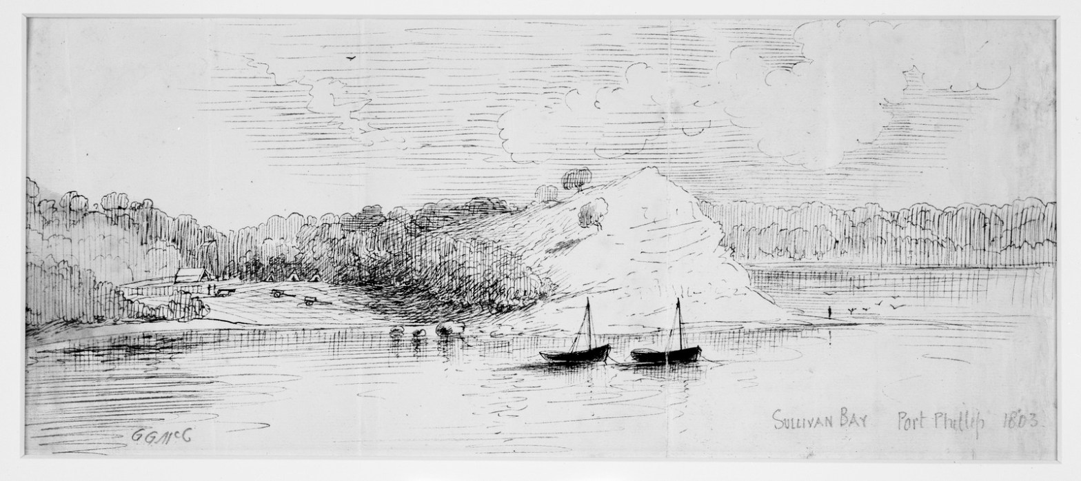
Lieutenant-Colonel David Collins first settled at Sullivan Bay near present-day Sorrento with a group of British convicts in October 1803. However, a lack of fresh water, poor sandy soil and shortages of timber suitable for building, together with violent clashes with the local Aboriginals, led to Collins to recommend a move to the Derwent River in Van Diemen’s Land, and upon receiving permission, he left in two ships on 30 January and 20 May 1804 to establish Hobart.
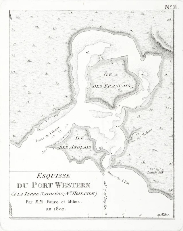
Between 1801-04 the voyage of the French explorer Nicolas Baudin charted much of the southern coastline including Western Port Bay and French Island. He included the description of “La Terre Napoleon”, covering much of what is now Victoria and South Australia. Onboard was artist Charles Alexandre Lesueur who drew exquisite sketches of the east coast of Tasmania in 1802 which show many small plumes of smoke from Aboriginal fires.
Starting from NSW in October 1824, Hamilton Hume and William Hovell began an expedition southward to find new grazing land. They spent three days attempting to cross the Great Dividing Range at Mt Disappointment but were thwarted by the thick mountain forests. They eventually reached Corio Bay on 16 December, but because of navigational errors and omissions they mistakenly concluded that they had reached Western Port. However, their enthusiastic reports led NSW Governor Sir Ralph Darling to establish another short-lived convict settlement at Corinella at Western Port in November 1826, in part to protect the approaches from French explorers.
Between 1829 and 1830, Charles Napier Sturt led an expedition along the Murray River, sparking interest in the vast red gum forests and potential for settlement of land to the south.
Meanwhile, the Henty brothers established a permanent settlement near Portland in 1834. They had been disappointed with the Swan River in Western Australia and were unable to secure a land grant in Tasmania, so they squatted illegally with their flocks of sheep.
Major Thomas Mitchell’s famous overland expedition arrived at Portland in August 1836, and he was surprised to find the small but prosperous community living off the fertile farmland. He termed the region “Australia Felix” which is Latin for “Fortunate Australia”.
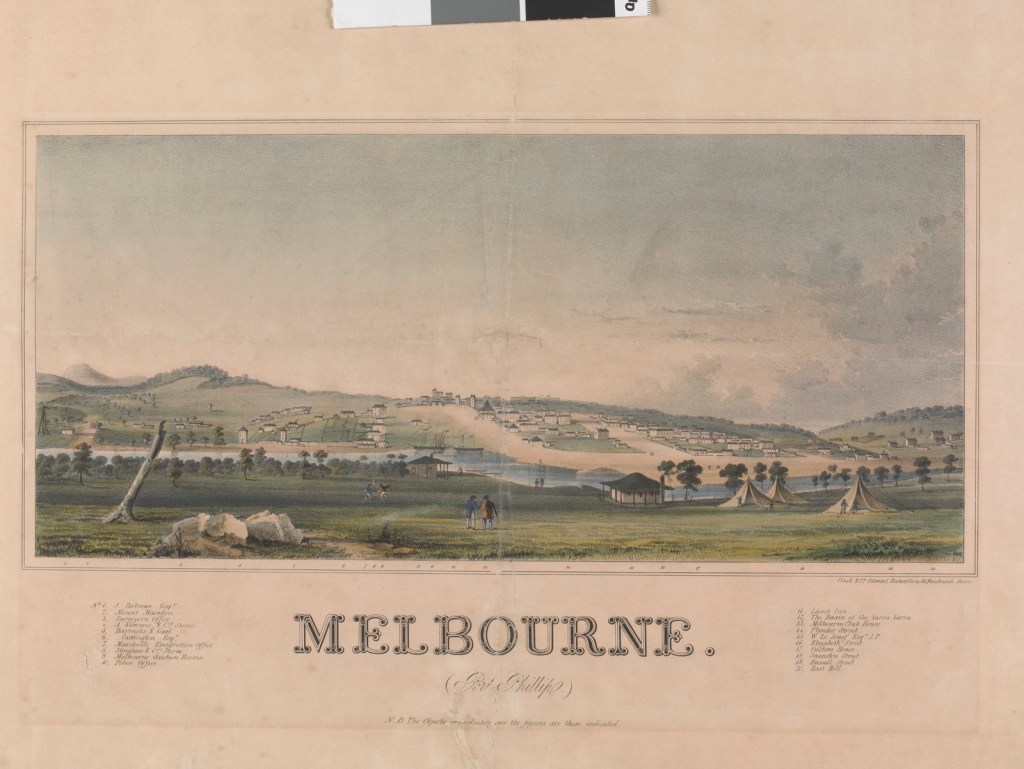
A year later in 1835, Australian grazier, entrepreneur and explorer, John Batman, led an expedition from Tasmania and claimed to have negotiated the purchase of over 600,000 acres of land between Port Phillip and Corio Bays from eight Wurundjeri elders in exchange for tools, blankets and food. He also famously identified a spot on the Yarra River which was to become the City of Melbourne and noted in his diary of 8 June 1835, “this will be the place for a village”. But Batman’s treaty was deemed illegal and subsequently rejected by Sydney-based Governor Sir Richard Bourke because Batman had no authority over Crown Land.
Crown Land was the principal asset of the British colonial government and its major source of power and revenue. To discourage similar illicit ventures in land dealing, the Sydney Government made Port Phillip a formal administrative division of New South Wales in September 1836 and established a magistrate’s office at Melbourne to administer new land regulations.
Pastoral runs spread over the following two years as far as Winchelsea, Inverleigh and Bacchus Marsh in the west, and Woodend and Kilmore in the north.
Timber licence regulations were also established under the Land Act which proved largely ineffective.
The timber industry was one of the first to establish in Melbourne to provide the raw materials for construction of buildings, wharves and fences. However, the pioneers of Port Phillip were largely from Tasmania, and they preferred to ship timber from sawmills and forests around Launceston and Hobart.
Melbourne’s first steam-powered sawmill was established by Alison and Knight in 1841 on the south-east corner of Collins and King Streets. And the first timber tramway in Victoria was built on the Portland jetty in 1846 to move loads between ships and the shore.
The main early explorers who ventured into the deep forests and mountains peaks of Gippsland included Angus McMillan in 1839 and Count Paul Strzelecki in 1840.
Prior to European discovery and settlement, Victoria was the home to many indigenous nations who had occupied the land for thousands of years and, over that time, had accumulated a deep knowledge and wisdom of the natural rhythms of the bush and fire.
The pre-colonial Aboriginal population of Victoria was estimated to be about 70,000, but European diseases such as smallpox decimated communities and reduced this number to less than 15,000.
Major impacts on native forests also occurred with the dispossession of Aboriginal people from their traditional lands between 1836 and 1842 associated with the establishment of extensive sheep runs. By 1845, fewer than 240 wealthy squatters held all the pastoral licences and became a powerful political and economic force in Victoria. There was often conflict between the new settlers and aboriginal communities over land and resources.
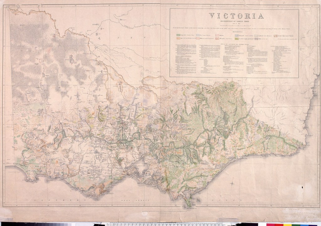
A map produced by the Mines Department in 1869 indicates that prior to European settlement, nearly 88% of Victoria had been forested, with the remaining 12% made up of open grasslands, coastal and alpine heathlands, lakes and mallee deserts. Alienation and sale of Crown Land with associated clearing of native forests for mining, roads, railways, pastures, agriculture, cities, towns and settlements over the subsequent century reduced this figure to about 36% by 2013.
The first European seafarers, explorers, surveyors and settlers witnessed and commented on aboriginal groups frequently lighting small and low intensity fires to burn the scrub. They also noted the open grassy forests and woodlands which they encountered.
Disruptions to the complex patchwork associated with traditional indigenous burning patterns undoubtedly led to profound changes to the state of Victoria’s native forests, particularly of the structure of the understory.
There is also strong evidence from pollen and charcoal particles found in lake sediments to suggest that major bushfires were more intense and more frequent following the arrival of Europeans.
By the late 1840s only about 75,000 Europeans occupied Victoria with Melbourne, Williamstown, Geelong and Portland as the dominant settlements. But the gold rush beginning in 1851 created a flood of miners and new settlers looking for land which led to major and lasting impacts on Victoria’s forests.


https://www.geelonggallery.org.au/collection/explore-the-collection/eugene-von-gu-rard-1804.

https://collections.sea.museum/collections
https://libraries.tas.gov.au/Digital/9905e829-187a-41ae-82f5-5db4944deeec
https://digitised-collections.unimelb.edu.au/handle/11343/23731


